Boase Wood

Wood, Forest in Fife

Scotland

Boase Wood

A918 St Andrews
A918 St Andrews Credit: thejackrustles

Boase Wood is a picturesque forest located in Fife, Scotland. Spanning an area of approximately 100 acres, this woodland is known for its natural beauty and rich biodiversity. The forest is situated near the village of Boase, making it easily accessible for visitors.

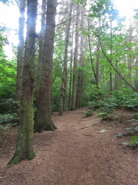
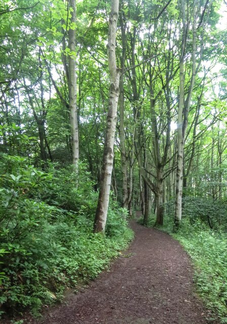
With its diverse range of tree species, Boase Wood offers a stunning display of vibrant colors throughout the year. It is home to a variety of native trees, including oak, birch, beech, and Scots pine. These towering trees create a dense canopy, providing shade and shelter for the many animals and birds that inhabit the area.

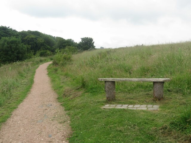
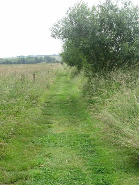
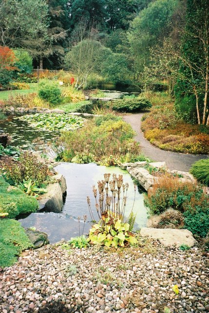
The forest floor is covered in a lush carpet of ferns, moss, and wildflowers, offering a tranquil and peaceful setting for nature lovers. Visitors can explore the winding trails that meander through the woods, taking in the sights and sounds of this enchanting environment.

Boase Wood is also home to a number of wildlife species. Red squirrels can be spotted darting among the branches, while deer can be seen grazing in the clearings. The birdlife is equally impressive, with species such as woodpeckers, owls, and various songbirds making their homes in the forest.

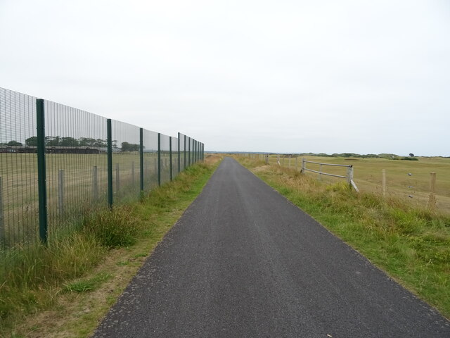
The forest is a popular destination for outdoor enthusiasts, offering opportunities for walking, hiking, and wildlife observation. It also provides a valuable space for environmental education and research, with its unique ecosystem and diverse flora and fauna.

Overall, Boase Wood is a captivating natural treasure in Fife, offering visitors a chance to immerse themselves in the beauty of Scotland's woodlands and connect with nature.

If you have any feedback on the listing, please let us know in the comments section below.

Boase Wood Images

Images are sourced within 2km of 56.33235/-2.8227643 or Grid Reference NO4915. Thanks to Geograph Open Source API. All images are credited.

A918 St Andrews
A918 St Andrews
St Andrews University grounds
Bus stop and shelter on the A91, St Andrews
Green on Old Course, St Andrews
Service road, St Andrews Golf Course
Driving range, St Andrews Golf Course
The Jigger Inn, St Andrews Golf Course
Sign for the Jigger Inn, St Andrews Golf Course
National Cycle Route 1 Heading west towards Guardbridge.
National Cycle Route 1
Heading west towards Guardbridge.
A917 towards Guardbridge
National Cycle Route 1 Beside the A91 - towards Guardbridge.
National Cycle Route 1
Beside the A91 - towards Guardbridge.
Balgove Larder farm shop and steak barn
Path through Cairns Den, near St Andrews
Bench in Lumbo Den, Fife Pilgrim Way
Fife Pilgrim Way through Lumbo Den
Path at Cairnsmill Reservoir
Benchmark on wall, Aikman Place, St Andrews Ordnance Survey benchmark, described on database at <span class="nowrap"><a title="https://www.bench-marks.org.uk/bm138903" rel="nofollow ugc noopener" href="https://www.bench-marks.org.uk/bm138903">Link</a><img style="margin-left:2px;" alt="External link" title="External link - shift click to open in new window" src="https://s1.geograph.org.uk/img/external.png" width="10" height="10"/></span>. See also <a href="https://www.geograph.org.uk/photo/7007158">NO4915 : Wall at Aikman Place, St Andrews</a>.
Benchmark on wall, Aikman Place, St Andrews
Ordnance Survey benchmark, described on database at LinkExternal link. See also NO4915 : Wall at Aikman Place, St Andrews.
Wall at Aikman Place, St Andrews There is an Ordnance Survey benchmark on this wall. See <a href="https://www.geograph.org.uk/photo/7006851">NO4915 : Benchmark on wall, Aikman Place, St Andrews</a>.
Wall at Aikman Place, St Andrews
There is an Ordnance Survey benchmark on this wall. See NO4915 : Benchmark on wall, Aikman Place, St Andrews.
Show me another place!

Boase Wood is located at Grid Ref: NO4915 (Lat: 56.33235, Lng: -2.8227643)

Unitary Authority: Fife

Police Authority: Fife

What 3 Words

///different.directly.slimmer. Near St Andrews, Fife

Related Wikis

Nearby Amenities

Located within 500m of 56.33235,-2.8227643
Mini Roundabout
Direction: clockwise
Lat/Long: 56.3294448/-2.8169646
Post Box
Collection Times: Mo-Fr 09:00; Sa 07:00
Operator: Royal Mail
Post Box Type: pillar
Ref: KY16 86D
Royal Cypher: scottish_crown
Lat/Long: 56.3352993/-2.8221379
Post Box
Postal Code: KY16
Ref: KY16 378
Lat/Long: 56.3343099/-2.8293247
Post Box
Collection Times: Mo-Fr 17:00; Sa 11:30
Operator: Royal Mail
Post Box Type: pillar
Ref: KY16 144
Royal Cypher: scottish_crown
Lat/Long: 56.3306187/-2.8288038
Bus Stop
Windsor Gardens
Bus: yes
Public Transport: platform
Shelter: yes
Lat/Long: 56.3288681/-2.8240034
Bus Stop
Bus: yes
Naptan AtcoCode: 6500N9955
Naptan NaptanCode: 34343473
Public Transport: platform
Lat/Long: 56.3358133/-2.8217068
Bus Stop
David Russell Apts
Naptan AtcoCode: 6500N0473
Naptan NaptanCode: 34343467
Lat/Long: 56.3353736/-2.8218984
Bus Stop
Bus: yes
Public Transport: platform
Shelter: yes
Lat/Long: 56.3353152/-2.8220208
Entrance: yes
Lat/Long: 56.333965/-2.8262438
Post Box
Collection Times: Mo-Fr 09:00; Sa 07:00
Operator: Royal Mail
Post Box Type: wall
Ref: KY16 363D
Royal Cypher: scottish_crown
Lat/Long: 56.3336536/-2.8172621
Bus Stop
Leonard Gardens
Bus: yes
Public Transport: platform
Shelter: yes
Lat/Long: 56.3284321/-2.8228027
Bus Stop
Moir Crescent
Bus: yes
Naptan AtcoCode: 6500N0505
Naptan Bearing: SW
Naptan CommonName: Moir Crescent
Naptan Indicator: opp
Naptan NaptanCode: 34343243
Naptan Street: Canongate
Naptan Verified: no
Public Transport: platform
Lat/Long: 56.3287362/-2.8188013
Bus Stop
Radernie Place
Naptan AtcoCode: 6500N0238
Naptan NaptanCode: 34343258
Lat/Long: 56.3299305/-2.8268995
Hallow Hill
Board Type: history
Information: board
Tourism: information
Lat/Long: 56.330809/-2.8207741
Bicycle Parking
Bicycle Parking: stands
Capacity: 8
Covered: no
Lat/Long: 56.3362305/-2.8259362
Bicycle Parking
Bicycle Parking: stands
Capacity: 14
Covered: no
Operator: David Russell Apartments
Source: Survey, Bing Maps
Lat/Long: 56.3357872/-2.8221619
Bicycle Parking
Bicycle Parking: stands
Capacity: 6
Covered: no
Operator: David Russell Apartments
Source: Survey, Bing Imagery
Lat/Long: 56.3363983/-2.8219634
Bicycle Parking
Bicycle Parking: stands
Capacity: 16
Covered: yes
Lat/Long: 56.3364559/-2.8258879
Bicycle Parking
Bicycle Parking: shed
Capacity: 20
Covered: yes
Operator: David Russell Apartments
Source: Survey, Bing Maps
Lat/Long: 56.3362436/-2.8217381
Bicycle Parking
Bicycle Parking: shed
Capacity: 20
Covered: yes
Lat/Long: 56.3365207/-2.8253477
Bicycle Parking
Bicycle Parking: stands
Capacity: 8
Covered: no
Operator: David Russell Apartments
Source: Survey, Bing Maps
Lat/Long: 56.3363135/-2.8212151
Bicycle Parking
Bicycle Parking: stands
Capacity: 16
Covered: yes
Lat/Long: 56.3367657/-2.8242196
Bicycle Parking
Bicycle Parking: stands
Capacity: 8
Covered: no
Lat/Long: 56.3365329/-2.8251703
Bicycle Parking
Bicycle Parking: wall_hoops
Capacity: 6
Covered: yes
Operator: David Russell Apartments
Source: Survey, Bing Maps
Lat/Long: 56.335805/-2.8207215
Bicycle Parking
Bicycle Parking: stands
Capacity: 8
Covered: no
Operator: David Russell Apartments
Source: Survey, Bing Maps
Lat/Long: 56.3359716/-2.8211427
Bicycle Parking
Bicycle Parking: stands
Capacity: 8
Covered: no
Operator: Fife Park
Source: survey
Lat/Long: 56.3359474/-2.824482
Bicycle Parking
Bicycle Parking: stands
Capacity: 2
Covered: no
Operator: David Russell Apartments
Source: survey
Lat/Long: 56.336067/-2.8248871
Bicycle Parking
Bicycle Parking: stands
Capacity: 8
Covered: no
Operator: David Russell Apartments
Source: survey
Lat/Long: 56.3359804/-2.8250171
Bicycle Parking
Bicycle Parking: stands
Capacity: 8
Covered: yes
Operator: David Russell Apartments
Source: survey
Lat/Long: 56.3360696/-2.8250681
Bicycle Parking
Bicycle Parking: stands
Capacity: 8
Covered: no
Operator: David Russell Apartments
Source: survey
Lat/Long: 56.3362005/-2.8249072
Bicycle Parking
Bicycle Parking: stands
Capacity: 8
Covered: no
Operator: David Russell Apartments
Source: Survey, Bing Maps
Lat/Long: 56.3367506/-2.821545
Bicycle Parking
Bicycle Parking: stands
Capacity: 8
Covered: no
Operator: David Russell Apartments
Source: Survey, Bing Maps
Lat/Long: 56.3367328/-2.821899
Bicycle Parking
Bicycle Parking: stands
Capacity: 8
Covered: no
Operator: David Russell Apartments
Source: survey and Bing
Lat/Long: 56.3359644/-2.8239148
Bicycle Parking
Bicycle Parking: stands
Capacity: 8
Covered: no
Operator: David Russell Apartments
Source: survey and Bing
Lat/Long: 56.3359719/-2.8234883
Bicycle Parking
Bicycle Parking: stands
Capacity: 8
Covered: no
Operator: David Russell Apartments
Source: survey and Bing
Lat/Long: 56.3359942/-2.8225589
Bicycle Parking
Bicycle Parking: stands
Capacity: 8
Covered: no
Operator: David Russell Apartments
Source: Survey, Bing Maps
Lat/Long: 56.3367135/-2.823047
Bicycle Parking
Bicycle Parking: stands
Capacity: 8
Covered: no
Operator: David Russell Apartments
Source: Survey, Bing Maps
Lat/Long: 56.3367179/-2.8226769
Bicycle Parking
Bicycle Parking: stands
Capacity: 8
Covered: no
Operator: David Russell Apartments
Source: survey and Bing
Lat/Long: 56.3365363/-2.8243027
Bicycle Parking
Bicycle Parking: stands
Capacity: 8
Covered: no
Operator: David Russell Apartments
Source: survey and Bing
Lat/Long: 56.3366033/-2.823954
Crossing
Crossing: traffic_signals
Crossing Ref: pelican
Kerb: lowered
Tactile Paving: yes
Lat/Long: 56.332702/-2.8244565
Leisure: garden
Lat/Long: 56.3361923/-2.8269132
Warning
Board Type: notice
Information: board
Tourism: information
Lat/Long: 56.3315541/-2.8198285
Warning
Board Type: notice
Information: board
Tourism: information
Lat/Long: 56.3318307/-2.8221365
Bus Stop
Bus: yes
Naptan AtcoCode: 6500N0483
Naptan NaptanCode: 34343462
Public Transport: platform
Lat/Long: 56.335138/-2.8267539
Bus Stop
John Knox Road
Bus: yes
Naptan AtcoCode: 6500N0231
Naptan NaptanCode: 34343252
Public Transport: platform
Lat/Long: 56.3297098/-2.8162417
Generator Method: photovoltaic
Generator Output Electricity: yes
Generator Source: solar
Generator Type: solar_photovoltaic_panel
Power: generator
Lat/Long: 56.328492/-2.8238216
Charging Station
Lat/Long: 56.3355376/-2.8209577
Cafe
Lat/Long: 56.336254/-2.8220992
Bar
Lat/Long: 56.336147/-2.8220082
Self Service: yes
Shop: laundry
Lat/Long: 56.3360797/-2.8247196
Crossing
Crossing: traffic_signals
Crossing Island: no
Tactile Paving: yes
Lat/Long: 56.3353706/-2.8201992
Traffic Calming: cushion
Lat/Long: 56.3353543/-2.8206753
Traffic Calming: cushion
Lat/Long: 56.3352509/-2.8240533
Crossing
Crossing: traffic_signals
Crossing Island: no
Tactile Paving: yes
Lat/Long: 56.3339781/-2.8163957
Traffic Calming: cushion
Lat/Long: 56.3341352/-2.8159398
Traffic Calming: cushion
Lat/Long: 56.3354797/-2.8170165
Traffic Calming: cushion
Lat/Long: 56.3332306/-2.8192253
Traffic Calming: cushion
Lat/Long: 56.3328919/-2.8211735
Traffic Calming: cushion
Lat/Long: 56.3328412/-2.8223001
Generator Method: photovoltaic
Generator Output Electricity: yes
Generator Source: solar
Generator Type: solar_photovoltaic_panel
Power: generator
Lat/Long: 56.3312294/-2.8242609
Generator Method: photovoltaic
Generator Output Electricity: yes
Generator Source: solar
Generator Type: solar_photovoltaic_panel
Power: generator
Lat/Long: 56.3330545/-2.8225575
Generator Method: photovoltaic
Generator Output Electricity: yes
Generator Source: solar
Generator Type: solar_photovoltaic_panel
Power: generator
Lat/Long: 56.333017/-2.8224832
Bus Stop
John Knox Road
Bus: yes
Naptan AtcoCode: 6500N0232
Naptan Bearing: NE
Naptan CommonName: John Knox Road
Naptan Indicator: opp
Naptan NaptanCode: 34343247
Naptan Street: Canongate
Naptan Verified: no
Public Transport: platform
Source: naptan;bing;naptan_compare_tool
Lat/Long: 56.3292808/-2.8175854
The data included in this document is from www.openstreetmap.org. The data is made available under ODbL.

Have you been to Boase Wood?

Leave your review of Boase Wood below (or comments, questions and feedback).