Calver Sough

Settlement in Derbyshire Derbyshire Dales

England

Calver Sough

Rainbow over Froggatt
Rainbow over Froggatt Credit: Colin Park

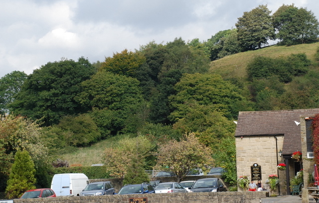
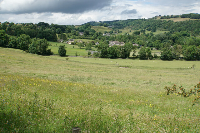
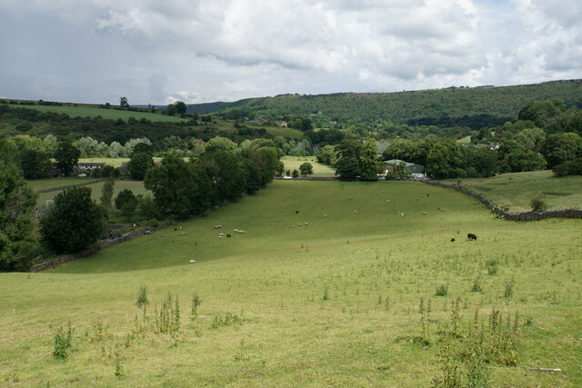
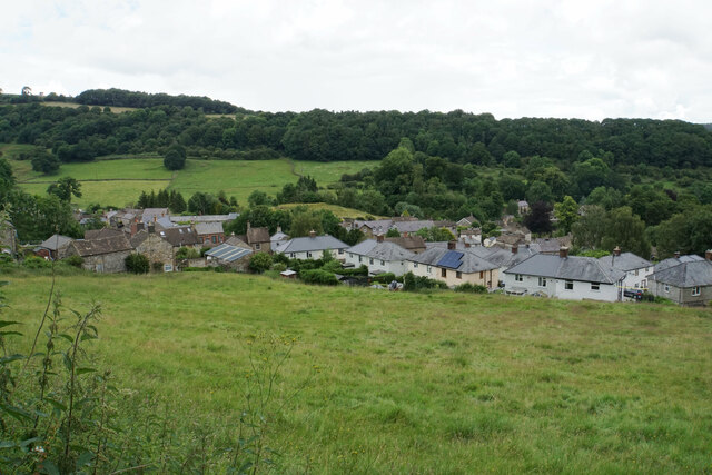
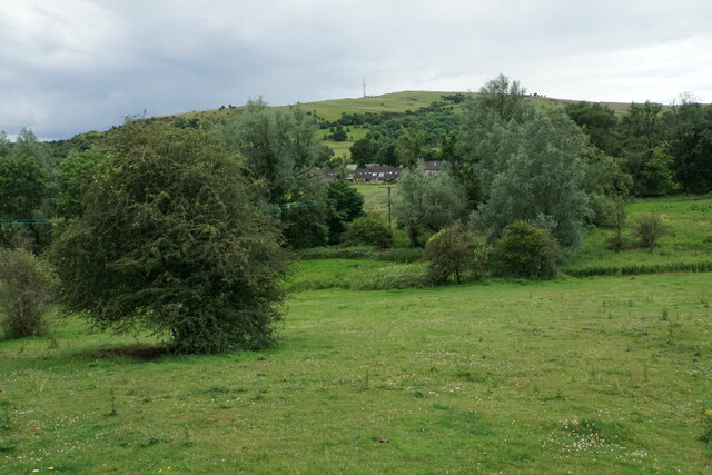
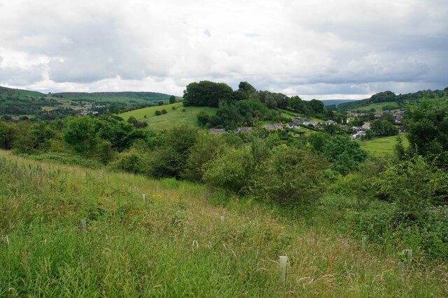
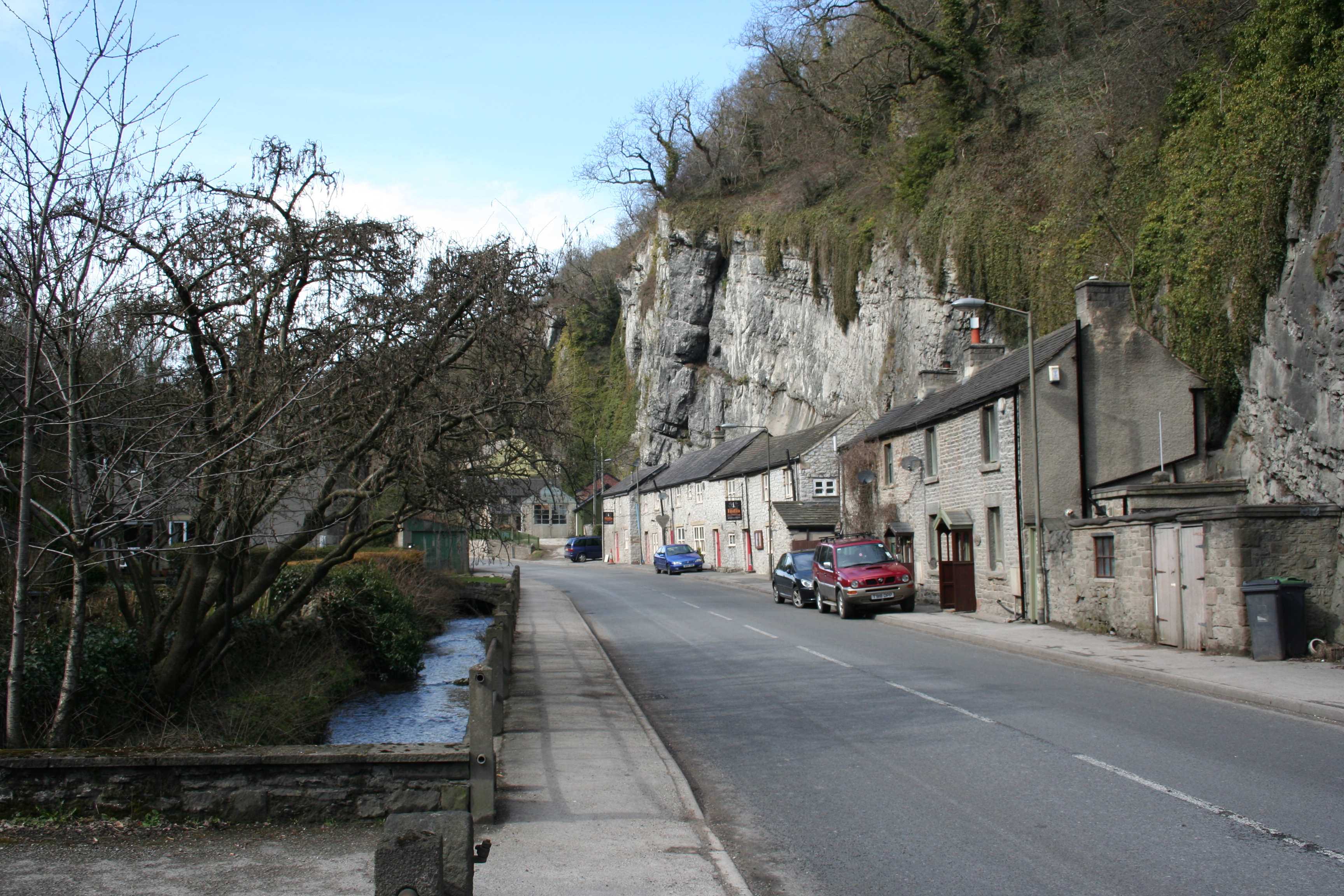
Calver Sough is a small village located in the Derbyshire Dales district of Derbyshire, England. Situated in the picturesque Peak District National Park, it lies on the banks of the River Derwent and is surrounded by stunning natural beauty.

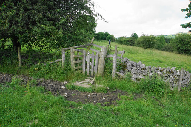
Historically, Calver Sough was a significant lead mining area during the 18th and 19th centuries, with numerous mines and smelting works operating in the vicinity. The name "sough" refers to the underground drainage channels used in the mining industry to remove water from the mineshaft. These channels can still be seen today, serving as a reminder of the village's industrial past.

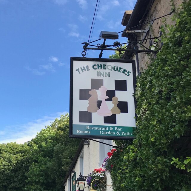
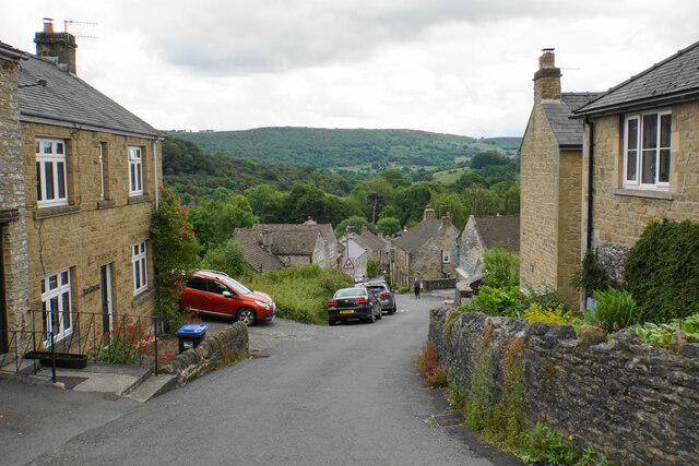
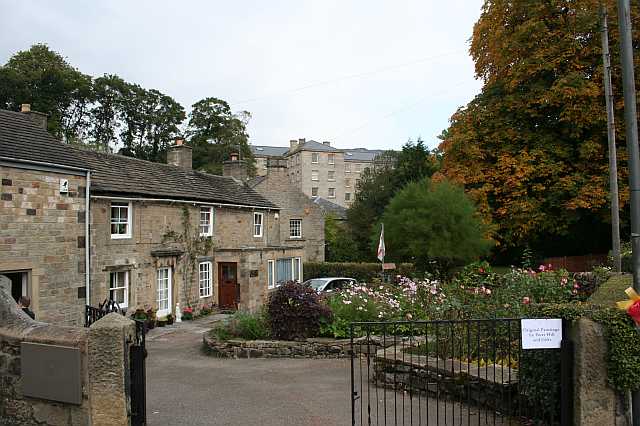
Today, Calver Sough is a charming and peaceful village, known for its idyllic countryside and quaint stone cottages. It offers a range of amenities for residents and visitors alike, including a village shop, a pub, and a primary school. The village is also home to several small businesses, including craft shops and a garden center.

Outdoor enthusiasts are drawn to Calver Sough due to its proximity to the Peak District's vast network of walking trails, cycling routes, and climbing spots. The nearby Chatsworth House, one of Britain's most renowned stately homes, is a popular attraction for tourists.

Overall, Calver Sough is a delightful village that seamlessly blends its rich industrial heritage with its natural beauty, making it an appealing destination for both history buffs and nature lovers.

If you have any feedback on the listing, please let us know in the comments section below.

Calver Sough Images

Images are sourced within 2km of 53.269638/-1.641603 or Grid Reference SK2474. Thanks to Geograph Open Source API. All images are credited.

Rainbow over Froggatt
Riley Graves enclosure near Eyam in Derbyshire The image has been scanned from an Agfa CT200 transparency.
Riley Graves enclosure near Eyam in Derbyshire
The image has been scanned from an Agfa CT200 transparency.
Alice Hancock's gravestone near Eyam, Derbyshire The image has been scanned from an Agfa CT200 transparency.
Alice Hancock's gravestone near Eyam, Derbyshire
The image has been scanned from an Agfa CT200 transparency.
Woodland behind the Eyre Arms This woodland on this hill behind the Eyre Arms is just to the south-west of the centre of SK27.
Woodland behind the Eyre Arms
This woodland on this hill behind the Eyre Arms is just to the south-west of the centre of SK27.
The Chequers Inn Former Wards brewery pub beside the A625 in Froggatt
The Chequers Inn
Former Wards brewery pub beside the A625 in Froggatt
The sign of The Chequers Inn See <a href="https://www.geograph.org.uk/photo/6922975">SK2476 : The Chequers Inn</a>.
The sign of The Chequers Inn
Chequers Inn wall plaque Dating back to the halcyon days of the Wards brewery in Sheffield.  Oh to be able to drink a pint of that excellent brew again!
Chequers Inn wall plaque
Dating back to the halcyon days of the Wards brewery in Sheffield. Oh to be able to drink a pint of that excellent brew again!
Crossroads in Calver A lot of people will only know Calver from these crossroads, as the A623 passes through, and the A625 turns off. There is a village green here, with more on the opposite side, but the village has quieter and more attractive bits.
Crossroads in Calver
A lot of people will only know Calver from these crossroads, as the A623 passes through, and the A625 turns off. There is a village green here, with more on the opposite side, but the village has quieter and more attractive bits.
Hillside below Calver Low Looking down towards Stoney Middleton. Eyam is just visible further up the far hill.
Hillside below Calver Low
Looking down towards Stoney Middleton. Eyam is just visible further up the far hill.
Field at the bottom of Coombs Dale The A623 runs at the other end of the field. The Derwent valley is in the background with Froggatt Edge on the far side.
Field at the bottom of Coombs Dale
The A623 runs at the other end of the field. The Derwent valley is in the background with Froggatt Edge on the far side.
Footpath and gate above Stoney Middleton The wooden structures around the gate show some evolutionary randomness.
Footpath and gate above Stoney Middleton
The wooden structures around the gate show some evolutionary randomness.
Hillside below Eaton Fold A chance to look down on the rooftops of Stoney Middleton.
Hillside below Eaton Fold
A chance to look down on the rooftops of Stoney Middleton.
Middleton Lane A steeply descending road through Stoney Middleton. The Derwent valley is in the distance.
Middleton Lane
A steeply descending road through Stoney Middleton. The Derwent valley is in the distance.
Green fields at the bottom of Middleton Dale Calver Peak is opposite.
Green fields at the bottom of Middleton Dale
Calver Peak is opposite.
Hillside above Stoke Brook The course of Stoke Brook below is obscured by shrubbery. Opposite is Hare Knoll and Calver.
Hillside above Stoke Brook
The course of Stoke Brook below is obscured by shrubbery. Opposite is Hare Knoll and Calver.
Fields by Knouchley Farm Looking down the Derwent Valley, with Curbar and Baslow Edges up on the left.
Fields by Knouchley Farm
Looking down the Derwent Valley, with Curbar and Baslow Edges up on the left.
Hilly farmland near Knouchley Farm Part of the western side of the Derwent valley opposite Froggatt.
Hilly farmland near Knouchley Farm
Part of the western side of the Derwent valley opposite Froggatt.
Path down to the Derwent Froggatt Edge is at the top of the other side.
Path down to the Derwent
Froggatt Edge is at the top of the other side.
Show me another place!

Calver Sough is located at Grid Ref: SK2474 (Lat: 53.269638, Lng: -1.641603)

Administrative County: Derbyshire

District: Derbyshire Dales

Police Authority: Derbyshire

What 3 Words

///listen.firmly.clenching. Near Baslow, Derbyshire

Related Wikis

Calver

Calver (Old English Calf Slope) is a village and civil parish in Derbyshire, England. The population of the civil parish at the 2011 census was 710....

Upper Derwent Valley

The Upper Derwent Valley is an area of the Peak District National Park in England. It largely lies in Derbyshire, but its north eastern area lies in Sheffield...

All Saints' Church, Curbar

All Saints’ Church, Curbar is a Church of England parish church in Curbar, Derbyshire. == History == Until the church was built, the nearest parish church...

Middleton Hall, Stoney Middleton

Middleton Hall is a restored 17th-century country house at Stoney Middleton, Derbyshire. It is a Grade II listed building.The house was built in the mid...

St Martin's Church, Stoney Middleton

St Martin's Church is a Grade II* listed parish church in the Church of England in Stoney Middleton, Derbyshire. == History == The church dates from the...

Curbar

Curbar is a village and civil parish in the Derbyshire Dales district of Derbyshire, England. The population based on the 2011 Census was 417. Curbar is...

Stoney Middleton

Stoney Middleton is a village and civil parish in the Derbyshire Dales district of Derbyshire, England. It is in the White Peak area of the Peak District...

Cliff College

Cliff College is a Christian theological college in Calver, Derbyshire, that teaches Biblical Theology at the undergraduate level and a number of mission...

Nearby Amenities

Located within 500m of 53.269638,-1.641603
Traffic Signals
Calver Crossroads
Junction: yes
Source: survey
Lat/Long: 53.2699173/-1.6429255
Calver
Is In: Derbyshire, England, UK
Place: village
Wikidata: Q2073921
Wikipedia: en:Calver
Lat/Long: 53.2684861/-1.6414898
Pub
The Derwentwater Arms
Lat/Long: 53.268364/-1.6411023
Hare Knoll
Natural: peak
Lat/Long: 53.2708583/-1.6384489
Calver Sough
Place: village
Lat/Long: 53.2700502/-1.6427789
Cafe
Cafe 19 at Whites
Addr City: Hope Valley
Addr Postcode: S32 3XH
Addr Street: Kingsgate
Addr Suburb: Calver
Contact Facebook: https://www.facebook.com/Cafe19atwhites/
Lat/Long: 53.2697342/-1.6424821
Barrier: stile
Source: survey;gps
Stile: squeezer
Lat/Long: 53.2688615/-1.6437036
Barrier: stile
Material: wood
Source: survey;gps
Stile: stepover
Lat/Long: 53.2691563/-1.645171
Barrier: stile
Material: stone
Source: survey;gps
Stile: stepover
Lat/Long: 53.2715617/-1.6358302
Barrier: stile
Material: stone
Source: survey;gps
Step Count: 2
Stile: stepover
Lat/Long: 53.2665639/-1.6446355
Cycleway: asl
Source: bing
Lat/Long: 53.2697268/-1.6428617
Cycleway: asl
Direction: forward
Source: bing
Lat/Long: 53.2701396/-1.6430987
Cycleway: asl
Source: bing
Lat/Long: 53.2698864/-1.6425365
Cycleway: asl
Source: bing
Lat/Long: 53.2699729/-1.6433938
Give Way
Direction: forward
Lat/Long: 53.2727962/-1.6433165
Calver (Shaldon)
Bus: yes
Public Transport: stop_position
Lat/Long: 53.2723774/-1.6434072
Barrier: stile
Material: stone
Source: survey;gps
Stile: squeezer
Lat/Long: 53.2665489/-1.6400864
Barrier: stile
Material: stone
Source: survey;gps
Stile: squeezer
Lat/Long: 53.266555/-1.640925
Barrier: stile
Material: stone
Source: survey;gps
Stile: squeezer
Lat/Long: 53.2665875/-1.641057
Barrier: entrance
Source: survey;gps
Lat/Long: 53.2672288/-1.6411239
Natural: stone
Lat/Long: 53.2685491/-1.6460589
Post Office
Calver Post Office
Addr City: Hope Valley
Addr Postcode: S32 3XH
Addr Street: Kingsgate
Addr Suburb: Calver
Opening Hours: Mo-Su 07:00-22:00
Ref Pol Id: 126118
Lat/Long: 53.2696492/-1.6421731
Historic: memorial
Lat/Long: 53.2678153/-1.6408699
Post Box
Collection Times: Mo-Fr 16:30; Sa 11:00
Note: Re-located from old Post Office, Main Street in 2015
Post Box Type: wall
Ref: S32 200
Royal Cypher: VR
Lat/Long: 53.2697002/-1.642078
Defibrillator
Access: yes
Check Date: 2023-03-09
Defibrillator Location: On outside wall. Available 24/7.
Emergency: defibrillator
Indoor: no
Opening Hours: 24/7
Ref GB The Circuit: 9DD63F59-C1CA-4D2F-92A3-3592785CEBCA
Lat/Long: 53.2697853/-1.6422877
Calver (Shaldon)
Bus: yes
Public Transport: stop_position
Lat/Long: 53.2720283/-1.6435391
Bus Stop
Calver Hassop Road
Bus: yes
Public Transport: platform
Lat/Long: 53.2683744/-1.6435052
Calver Hassop Road
Bus: yes
Public Transport: stop_position
Lat/Long: 53.2683754/-1.6435641
Bus Stop
Calver Hassop Road
Bus: yes
Naptan AtcoCode: 1000DCHR3746
Naptan NaptanCode: dbsdpgaj
Public Transport: platform
Lat/Long: 53.2672011/-1.6443549
Calver Hassop Road
Bus: yes
Public Transport: stop_position
Lat/Long: 53.267187/-1.6442698
Bus Stop
Calver (Shaldon)
Bus: yes
Public Transport: platform
Lat/Long: 53.2723671/-1.6433448
Bus Stop
Calver (Shaldon)
Bus: yes
Public Transport: platform
Lat/Long: 53.2720274/-1.6436139
Bus Stop
Calver Sough
Bus: yes
Naptan AtcoCode: 1000DCSG3244
Naptan NaptanCode: dbsajtpj
Public Transport: platform
Lat/Long: 53.2706103/-1.6435716
Bus Stop
Calver Sough
Bus: yes
Naptan AtcoCode: 1000DCSG3312
Naptan NaptanCode: dbsajtpm
Public Transport: platform
Lat/Long: 53.2706299/-1.6433255
Calver Sough
Bus: yes
Public Transport: stop_position
Lat/Long: 53.2706388/-1.643469
Calver Sough
Bus: yes
Public Transport: stop_position
Lat/Long: 53.2706116/-1.64345
Bus Stop
Calver Crossroads
Bus: yes
Public Transport: platform
Lat/Long: 53.2700525/-1.6437771
Calver Crossroads
Bus: yes
Public Transport: stop_position
Lat/Long: 53.2700936/-1.6437577
Bus Stop
Calver Crossroads
Bus: yes
Naptan AtcoCode: 1000DCSG3080
Naptan NaptanCode: dbsajtpd
Public Transport: platform
Lat/Long: 53.2703202/-1.6441289
Calver Crossroads
Bus: yes
Public Transport: stop_position
Lat/Long: 53.2702865/-1.6441747
Defibrillator
Access: yes
Check Date: 2023-03-09
Defibrillator Location: On outside wall. Available 24/7.
Emergency: defibrillator
Indoor: no
Lat/Long: 53.2664105/-1.6374398
Generator Method: photovoltaic
Generator Output Electricity: yes
Generator Source: solar
Generator Type: solar_photovoltaic_panel
Location: roof
Power: generator
Lat/Long: 53.2682158/-1.6426185
Generator Method: photovoltaic
Generator Output Electricity: yes
Generator Source: solar
Generator Type: solar_photovoltaic_panel
Location: roof
Power: generator
Lat/Long: 53.2680875/-1.64242
Generator Method: photovoltaic
Generator Output Electricity: yes
Generator Source: solar
Generator Type: solar_photovoltaic_panel
Location: roof
Power: generator
Lat/Long: 53.2682736/-1.642015
Generator Method: photovoltaic
Generator Output Electricity: yes
Generator Source: solar
Generator Type: solar_photovoltaic_panel
Location: roof
Power: generator
Lat/Long: 53.2690644/-1.6395929
Generator Method: photovoltaic
Generator Output Electricity: yes
Generator Source: solar
Generator Type: solar_photovoltaic_panel
Location: roof
Power: generator
Lat/Long: 53.266584/-1.6370815
Generator Method: photovoltaic
Generator Output Electricity: yes
Generator Source: solar
Generator Type: solar_photovoltaic_panel
Location: roof
Power: generator
Lat/Long: 53.2666112/-1.6369983
Generator Method: photovoltaic
Generator Output Electricity: yes
Generator Source: solar
Generator Type: solar_photovoltaic_panel
Location: roof
Power: generator
Lat/Long: 53.2666209/-1.6368133
Generator Method: photovoltaic
Generator Output Electricity: yes
Generator Source: solar
Generator Type: solar_photovoltaic_panel
Location: roof
Power: generator
Lat/Long: 53.2663466/-1.6368723
Generator Method: photovoltaic
Generator Output Electricity: yes
Generator Source: solar
Generator Type: solar_photovoltaic_panel
Location: roof
Power: generator
Lat/Long: 53.2663305/-1.636934
Generator Method: photovoltaic
Generator Output Electricity: yes
Generator Source: solar
Generator Type: solar_photovoltaic_panel
Location: roof
Power: generator
Lat/Long: 53.2663161/-1.6369635
Location Transition: yes
Operator: National Grid Electricity Distribution
Power: pole
Lat/Long: 53.2661827/-1.6389075
Location Transition: yes
Material: wood
Operator: National Grid Electricity Distribution
Power: pole
Lat/Long: 53.2729472/-1.6450645
Direction: 38
Tourism: viewpoint
Lat/Long: 53.2684854/-1.6459943
Noexit: yes
Lat/Long: 53.2683795/-1.6450408
Access: private
Barrier: stile
Lat/Long: 53.2684006/-1.6450611
Bench
Backrest: yes
Lat/Long: 53.268996/-1.6414086
Bench
Backrest: yes
Lat/Long: 53.26887/-1.6407735
Bench
Backrest: no
Lat/Long: 53.2678159/-1.6408482
The data included in this document is from www.openstreetmap.org. The data is made available under ODbL.

Have you been to Calver Sough?

Leave your review of Calver Sough below (or comments, questions and feedback).