Carew Cross

Heritage Site in Pembrokeshire

Wales

Carew Cross

Carew Tidal Mill Following a fire in 1955 which destroyed a similar building in Pembroke, this tidal mill remains the only one of its kind in Wales.

A mill of some kind has existed here since as early as 1542 but the present building dates from the early 19th century. One of the two mill wheels carries the date 1801. The term “French Mill”, often used about Carew, may be a reference to the use of French burr stones. It is hoped that the south wheel will at least be able to turn some of the auxiliary machinery on a regular basis in the future.

Thanks to another contributor for some of the additional historic information.
Carew Tidal Mill Credit: Garth Newton

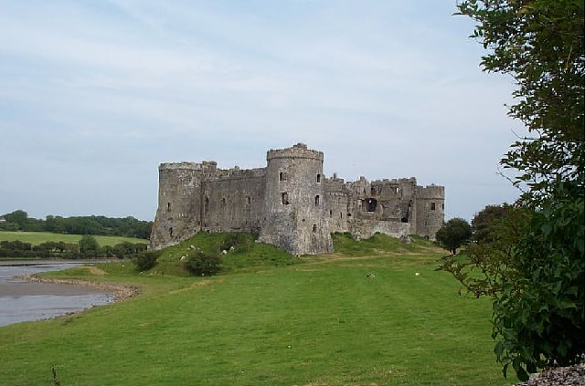
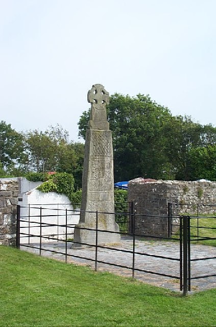
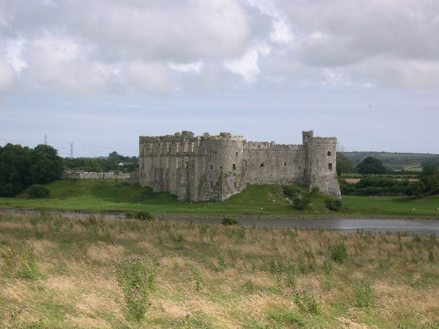
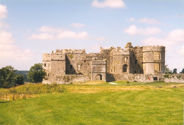
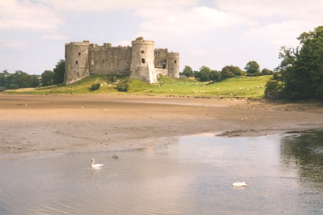
Carew Cross is a historical monument located in the village of Carew in Pembrokeshire, Wales. It is a significant heritage site that holds great cultural and historical importance. The cross is situated in the grounds of Carew Castle, a medieval fortress that dates back to the 12th century.

The Carew Cross is believed to have been erected in the 11th century and stands at an impressive height of 4.5 meters. It is a Celtic-style cross made from local limestone and features intricate carvings that depict various Christian scenes such as the crucifixion of Jesus Christ and biblical figures like Adam and Eve.

The cross is adorned with beautiful decorative patterns, including interlacing motifs and knotwork, which are typical of the Celtic art style. It is considered to be one of the finest examples of early medieval stone carving in Wales.

Over the years, the Carew Cross has suffered damage and decay due to weathering and vandalism. However, it has undergone several restoration projects to preserve its historical significance. Today, it is protected as a Scheduled Ancient Monument and is a popular attraction for visitors interested in Welsh history and culture.

Carew Cross serves as a testament to the rich heritage of Pembrokeshire and offers a glimpse into the region's early Christian period. Its location within the picturesque grounds of Carew Castle further enhances its appeal, providing visitors with an immersive historical experience.

If you have any feedback on the listing, please let us know in the comments section below.

Carew Cross Images

Images are sourced within 2km of 51.698/-4.8278 or Grid Reference SN0403. Thanks to Geograph Open Source API. All images are credited.

Carew Tidal Mill Following a fire in 1955 which destroyed a similar building in Pembroke, this tidal mill remains the only one of its kind in Wales.

A mill of some kind has existed here since as early as 1542 but the present building dates from the early 19th century. One of the two mill wheels carries the date 1801. The term “French Mill”, often used about Carew, may be a reference to the use of French burr stones. It is hoped that the south wheel will at least be able to turn some of the auxiliary machinery on a regular basis in the future.

Thanks to another contributor for some of the additional historic information.
Carew Tidal Mill
Following a fire in 1955 which destroyed a similar building in Pembroke, this tidal mill remains the only one of its kind in Wales. A mill of some kind has existed here since as early as 1542 but the present building dates from the early 19th century. One of the two mill wheels carries the date 1801. The term “French Mill”, often used about Carew, may be a reference to the use of French burr stones. It is hoped that the south wheel will at least be able to turn some of the auxiliary machinery on a regular basis in the future. Thanks to another contributor for some of the additional historic information.
Carew Castle Carew Castle hosted the Great Tournament, following Sir Rhys ap Thomas' appointment by Henry VII to the status of Knight of the Garter for his assistance in defeating Richard III at Bosworth Field.

Recent archaeology has discovered evidence that a Celtic fort, possibly as early as the 8th century BC, existed many centuries before the castle was built.

Gerald de Windsor, sheriff of Pembroke Castle, gained the land at Carew as part of the dowry on his marriage to Helen Nest, the daughter of the late Welsh king, Rhys ap Tewdwr. All that remains from the castle he built, in about 1100, is a wall from a tower, now part of the East Range.

In the late 13th century Sir Nicholas Carew completely rebuilt the castle including the West Range with a new Great Hall flanked by two massive drum towers.

Thanks to another contributor for some of the additional historic information.
Carew Castle
Carew Castle hosted the Great Tournament, following Sir Rhys ap Thomas' appointment by Henry VII to the status of Knight of the Garter for his assistance in defeating Richard III at Bosworth Field. Recent archaeology has discovered evidence that a Celtic fort, possibly as early as the 8th century BC, existed many centuries before the castle was built. Gerald de Windsor, sheriff of Pembroke Castle, gained the land at Carew as part of the dowry on his marriage to Helen Nest, the daughter of the late Welsh king, Rhys ap Tewdwr. All that remains from the castle he built, in about 1100, is a wall from a tower, now part of the East Range. In the late 13th century Sir Nicholas Carew completely rebuilt the castle including the West Range with a new Great Hall flanked by two massive drum towers. Thanks to another contributor for some of the additional historic information.
Carew Cross An 11th century Celtic cross, one of the finest free-standing ancient stone crosses in the UK, erected to the memory of the last King of Dyfed (Maredydd ap Edwin, d.1035), although it may have been originally used to commemorate the gift of this land by Maredydd to The Church. An agreed translation for the abbreviated Latin inscription was reached only in the 1940s.
(Additional historic information provided by Martin Evans - thanks. GN)
Carew Cross
An 11th century Celtic cross, one of the finest free-standing ancient stone crosses in the UK, erected to the memory of the last King of Dyfed (Maredydd ap Edwin, d.1035), although it may have been originally used to commemorate the gift of this land by Maredydd to The Church. An agreed translation for the abbreviated Latin inscription was reached only in the 1940s. (Additional historic information provided by Martin Evans - thanks. GN)
View of Carew Castle
Ford at Carew Cheriton A 'water lane' or linear ford running west from the church.
Ford at Carew Cheriton
A 'water lane' or linear ford running west from the church.
Ford in use, Carew Cheriton Another view of the 'water lane' when in use by a farm vehicle.  Fortunately there is a dry footpath at the side. The submerged part of the lane has alter been closed to traffic, see <span class="nowrap"><a title="http://www.wetroads.co.uk/pembrokeshire.htm" rel="nofollow ugc noopener" href="http://www.wetroads.co.uk/pembrokeshire.htm">Link</a><img style="margin-left:2px;" alt="External link" title="External link - shift click to open in new window" src="https://s1.geograph.org.uk/img/external.png" width="10" height="10"/></span> .
Ford in use, Carew Cheriton
Another view of the 'water lane' when in use by a farm vehicle. Fortunately there is a dry footpath at the side. The submerged part of the lane has alter been closed to traffic, see LinkExternal link .
Charnel House, Carew Cheriton This is in the churchyard.  It was built in the 14C for the deposit of exhumed bones, with a chapel on the upper floor.  It was converted to a school in the 17C.
Charnel House, Carew Cheriton
This is in the churchyard. It was built in the 14C for the deposit of exhumed bones, with a chapel on the upper floor. It was converted to a school in the 17C.
Carew Castle from the east This view shows the Middle Gatehouse, built c.1500, and on the right the curved end of the Elizabethan North Range.
Carew Castle from the east
This view shows the Middle Gatehouse, built c.1500, and on the right the curved end of the Elizabethan North Range.
Carew Castle from the west The castle was built on a hill. overlooking the estuary of the Carew River.  The two massive corner towers were built in the early 14C, and were later adapted to form part of the Elizabethan mansion.
Carew Castle from the west
The castle was built on a hill. overlooking the estuary of the Carew River. The two massive corner towers were built in the early 14C, and were later adapted to form part of the Elizabethan mansion.
Saltmarsh at Tything Barn Whole area, as far as the trees in the distance, is covered at high tide
Saltmarsh at Tything Barn
Whole area, as far as the trees in the distance, is covered at high tide
Carew The entrance to Carew karting circuit from Sageston roundabout.
Carew
The entrance to Carew karting circuit from Sageston roundabout.
Crossroads on B4318 Looking from the truncated remains of the lane leading to the disused Pincheston Quarry. The lane opposite becomes Coal Lane.
Crossroads on B4318
Looking from the truncated remains of the lane leading to the disused Pincheston Quarry. The lane opposite becomes Coal Lane.
Tunnel for pedestrians under recently diverted A77(T) From the edge of the site of the former Pincheston Quarry. Disused (and derelict) limekiln behind.
Tunnel for pedestrians under recently diverted A77(T)
From the edge of the site of the former Pincheston Quarry. Disused (and derelict) limekiln behind.
Zoar Congregational Chapel, Carew Newton Now a private dwelling but retains plaque on the wall to the right stating its origins.
Zoar Congregational Chapel, Carew Newton
Now a private dwelling but retains plaque on the wall to the right stating its origins.
Carew River Near high tide. At low tide there is only a stream visible.
Carew River
Near high tide. At low tide there is only a stream visible.
Footpath South from Rosemary Lane The taller (browning) vegetation running across (behind the top bar of the gate) marks the position of a (now dry) stream.
Footpath South from Rosemary Lane
The taller (browning) vegetation running across (behind the top bar of the gate) marks the position of a (now dry) stream.
Telephone box near minor crossroads
Lane through Cresselly Big Wood
Show me another place!

Carew Cross is located at Grid Ref: SN0403 (Lat: 51.698, Lng: -4.8278)

Unitary Authority: Pembrokeshire

Police Authority: Dyfed Powys

What 3 Words

///sapping.speedily.clever. Near Jeffreyston, Pembrokeshire

Related Wikis

Carew Cross

Carew Cross (Welsh: Croes Caeriw) is an 11th-century Grade I listed monument in the village of Carew, Pembrokeshire, Wales. == Description == The cross...

Carew, Pembrokeshire

Carew (Welsh: Caeriw) is a village, parish and community on an inlet of Milford Haven in the former Hundred of Narberth, Pembrokeshire, West Wales, 4 miles...

Carew Castle

Carew Castle (Welsh: Castell Caeriw) is a castle in the civil parish of Carew in Pembrokeshire, Wales. The Carew family take their name from this site...
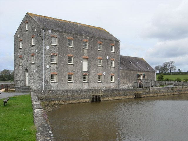
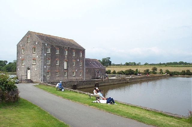
Carew Tidal Mill

Carew Tidal Mill (Welsh: Melin Caeriw), also called the French Mill, is a corn mill in Pembrokeshire, Wales, powered by tidal water. It was built around...

Nearby Amenities

Located within 500m of 51.698,-4.8278
Carew
Name Cy: Caeriw
Name En: Carew
Place: village
Wikidata: Q3397670
Lat/Long: 51.69831/-4.8278557
Carew Cross
Historic: wayside_cross
Tourism: attraction
Wikidata: Q17742272
Wikipedia: en:Carew Cross
Lat/Long: 51.6980317/-4.8278103
Pub
Carew Inn
Wikidata: Q29485287
Lat/Long: 51.6981102/-4.8274941
Bench
Lat/Long: 51.7002193/-4.8324757
Bench
Lat/Long: 51.7000898/-4.8332383
Bench
Lat/Long: 51.7002312/-4.8321615
Bench
Lat/Long: 51.7002041/-4.8323189
Give Way
Direction: forward
Lat/Long: 51.698225/-4.827629
Give Way
Direction: backward
Lat/Long: 51.6994941/-4.8262786
Give Way
Direction: backward
Lat/Long: 51.6976057/-4.8278115
Barrier: stile
Material: stone
Stile: stepover
Lat/Long: 51.7014692/-4.8296505
Flamish Chimney
Historic: ruins
Lat/Long: 51.6979596/-4.8256971
Bench
Backrest: yes
Lat/Long: 51.7001032/-4.8330867
Bench
Backrest: yes
Lat/Long: 51.7000093/-4.8299045
Bench: yes
Leisure: picnic_table
Lit: no
Material: wood
Lat/Long: 51.7002101/-4.8295043
Direction: 105
Generator Method: photovoltaic
Generator Output Electricity: yes
Generator Solar Modules: 8
Generator Source: solar
Generator Type: solar_photovoltaic_panel
Location: roof
Power: generator
Lat/Long: 51.6967659/-4.8244411
Telephone
Booth: K6
Covered: booth
Listed Status: Grade II
Operator: BT
Phone: +44 1646 651223
Lat/Long: 51.698127/-4.8265243
Post Box
Post Box Type: lamp
Royal Cypher: EIIR
Royal Cypher Wikidata: Q33102113
Lat/Long: 51.6981312/-4.8265519
Waste Basket
Lat/Long: 51.6981201/-4.826467
The data included in this document is from www.openstreetmap.org. The data is made available under ODbL.

Have you been to Carew Cross?

Leave your review of Carew Cross below (or comments, questions and feedback).