Bromley Hall

Settlement in Staffordshire Stafford

England

Bromley Hall

Free Gospel Chapel The Chapel, built in 1874 according to the stone above the door, appears to be under development for residential use.
Free Gospel Chapel Credit: Peter Fleming

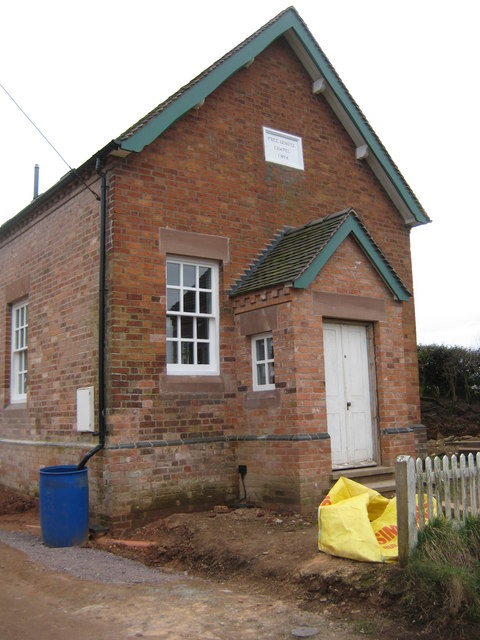
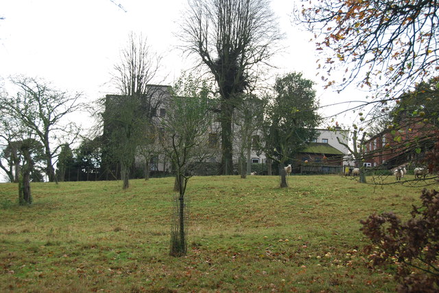
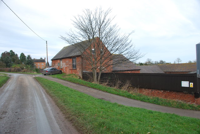
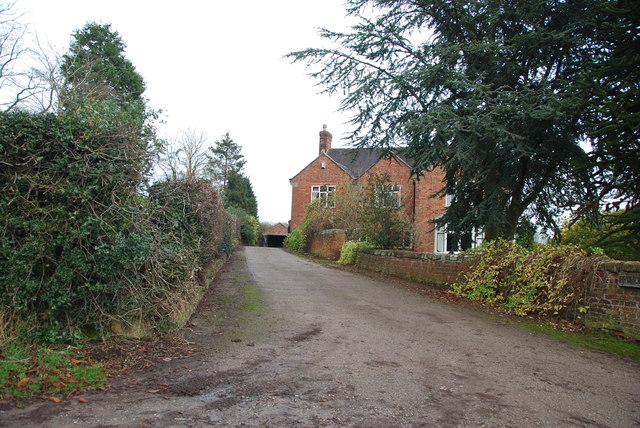
Bromley Hall is a historic building located in Staffordshire, England. Situated near the village of Abbots Bromley, the hall is a Grade II listed mansion that dates back to the 18th century. It is known for its impressive architectural design and picturesque surroundings.

The hall was originally built in the Georgian style and has since undergone various renovations and additions. It features a symmetrical façade with large sash windows, decorative cornices, and a prominent central entrance. The interior of the hall boasts spacious rooms with high ceilings, intricate plasterwork, and elegant period features.

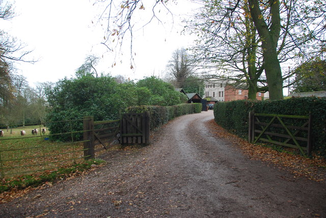
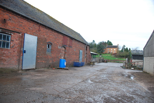
Surrounded by beautiful landscaped gardens and parkland, Bromley Hall offers breathtaking views of the Staffordshire countryside. The property includes extensive grounds that feature mature trees, rolling lawns, and a serene lake. These natural elements contribute to the hall's overall charm and tranquility.

Over the years, Bromley Hall has served different purposes and has been home to various notable families. Today, the hall is privately owned and has been converted into luxury apartments. The restoration work has preserved its historical character while incorporating modern amenities, making it an attractive residential option for those seeking a unique and prestigious living space.

With its rich history, stunning architecture, and idyllic setting, Bromley Hall stands as a significant landmark in Staffordshire, offering a glimpse into the area's past while providing a comfortable and luxurious living environment.

If you have any feedback on the listing, please let us know in the comments section below.

Bromley Hall Images

Images are sourced within 2km of 52.90294/-2.3433882 or Grid Reference SJ7734. Thanks to Geograph Open Source API. All images are credited.

Free Gospel Chapel The Chapel, built in 1874 according to the stone above the door, appears to be under development for residential use.
Free Gospel Chapel
The Chapel, built in 1874 according to the stone above the door, appears to be under development for residential use.
Stile and footpath to Chatcull
Entrance to Charnes Old Hall farm
Road through Charnes estate This road with its metal fences and avenue of trees, gives the impression that there is large estate nearby.   see link  <span class="nowrap"><a title="http://www.britishlistedbuildings.co.uk/en-272232-charnes-hall-eccleshall" rel="nofollow ugc noopener" href="http://www.britishlistedbuildings.co.uk/en-272232-charnes-hall-eccleshall">Link</a><img style="margin-left:2px;" alt="External link" title="External link - shift click to open in new window" src="https://s1.geograph.org.uk/img/external.png" width="10" height="10"/></span>
Road through Charnes estate
This road with its metal fences and avenue of trees, gives the impression that there is large estate nearby. see link LinkExternal link
Charnes Hall, Eccleshall It is a pity that this old hall is partly covered by trees.  see link  <span class="nowrap"><a title="http://www.britishlistedbuildings.co.uk/en-272232-charnes-hall-eccleshall" rel="nofollow ugc noopener" href="http://www.britishlistedbuildings.co.uk/en-272232-charnes-hall-eccleshall">Link</a><img style="margin-left:2px;" alt="External link" title="External link - shift click to open in new window" src="https://s1.geograph.org.uk/img/external.png" width="10" height="10"/></span>
Charnes Hall, Eccleshall
It is a pity that this old hall is partly covered by trees. see link LinkExternal link
The driveway to Charnes Hall
Looking back to a road junction near the Ashley Road Plantation
Narrow roadway leading to Bromley Mill Farm
Roadway past Bromley Mill Farm I can't find any information about this mill, and mill pool, which is out of sight on the left of picture.
Roadway past Bromley Mill Farm
I can't find any information about this mill, and mill pool, which is out of sight on the left of picture.
Entrance drive to Bromley Mill Farm House
The yard at Bromley Mill Farm Bromley Mill farmhouse can be seen beyond the yard, it is in square SJ7835.
The yard at Bromley Mill Farm
Bromley Mill farmhouse can be seen beyond the yard, it is in square SJ7835.
Longfield Cottage at Wetwood This is a charming cottage in the hamlet of Wetwood, the date on the front is 1921.
Longfield Cottage at Wetwood
This is a charming cottage in the hamlet of Wetwood, the date on the front is 1921.
Wetwood Manor, Wetwood
Looking towards Fairoak The drive on the left leads up to a property named The Mount.
Looking towards Fairoak
The drive on the left leads up to a property named The Mount.
Well Cottage, Fairoak The coach going by Well Cottage, gives some idea how of narrow the lanes are around here.
Well Cottage, Fairoak
The coach going by Well Cottage, gives some idea how of narrow the lanes are around here.
Rookery Cottages near Wetwood This row of cottages are very eyecatching as you drive by. The chimneys are worth looking at, there has been a lot of pride taken when building them.
Rookery Cottages near Wetwood
This row of cottages are very eyecatching as you drive by. The chimneys are worth looking at, there has been a lot of pride taken when building them.
Junction on Eccleshall Road, Wetwood
Garden at the entrance to Broughton Hall This is also the home for the Caudwell lyme disease charity. <span class="nowrap"><a title="https://caudwelllyme.com/" rel="nofollow ugc noopener" href="https://caudwelllyme.com/">Link</a><img style="margin-left:2px;" alt="External link" title="External link - shift click to open in new window" src="https://s1.geograph.org.uk/img/external.png" width="10" height="10"/></span>
Garden at the entrance to Broughton Hall
This is also the home for the Caudwell lyme disease charity. LinkExternal link
Show me another place!

Bromley Hall is located at Grid Ref: SJ7734 (Lat: 52.90294, Lng: -2.3433882)

Administrative County: Staffordshire

District: Stafford

Police Authority: Staffordshire

What 3 Words

///keep.walled.finishers. Near Standon, Staffordshire

Related Wikis

Ashley, Staffordshire

Ashley is a village and former civil parish, now in the parish of Loggerheads, in the Newcastle-under-Lyme district, in the county of Staffordshire, England...

Armsdale

Armsdale is a village in Staffordshire, England. Population details for the 2011 census can be found under Eccleshall.

Croxton, Staffordshire

Croxton is a village on the B5026 between Eccleshall and Loggerheads. Population details for the 2011 census can be found under Eccleshall. It is notable...

Loggerheads, Staffordshire

Loggerheads is a village and civil parish in north-west Staffordshire, England, on the A53 between Market Drayton and Newcastle-under-Lyme. == Name... ==

Outlands, Staffordshire

Outlands is a hamlet in the English county of Staffordshire. It lies 1 km eas of Bishop's Offley. == External links == Map sources for Outlands, Staffordshire

Bowers, Staffordshire

Bowers is a village in Staffordshire, England. For population details as taken in the 2011 census see Standon.

Jackson's Coppice and Marsh

Jackson's Coppice and Marsh is a nature reserve of the Staffordshire Wildlife Trust. It is along the River Sow, near the village of Bishop's Offley and...

Standon, Staffordshire

Standon is a village and civil parish in the Stafford district, in the county of Staffordshire, England. Standon has a church called Church of All Saints...

Nearby Amenities

Located within 500m of 52.90294,-2.3433882
Bus Stop
Broughton Hall
Naptan AtcoCode: 3800C701300
Naptan Bearing: SE
Naptan CommonName: Broughton Hall
Naptan Indicator: Adj
Naptan Landmark: Broughton Hall
Naptan Street: Eccleshall Rd
Naptan Verified: no
Source: naptan_import
Lat/Long: 52.9013704/-2.3501767
Barrier: stile
Lat/Long: 52.9002796/-2.3484679
Barrier: stile
Lat/Long: 52.8987924/-2.3443898
Broughton
Place: hamlet
Lat/Long: 52.9011487/-2.3475763
The data included in this document is from www.openstreetmap.org. The data is made available under ODbL.

Have you been to Bromley Hall?

Leave your review of Bromley Hall below (or comments, questions and feedback).