Cuddesdon and Denton

Civil Parish in Oxfordshire South Oxfordshire

England

Cuddesdon and Denton

Farmland, Great Milton A crop of beans with a building on the Wheatley campus of Oxford Brookes University seen in the background.
Farmland, Great Milton Credit: Andrew Smith

Cuddesdon and Denton is a civil parish located in the county of Oxfordshire, England. It is situated approximately 5 miles east of the city of Oxford. The parish is made up of two villages, Cuddesdon and Denton, both of which have their own unique characteristics.

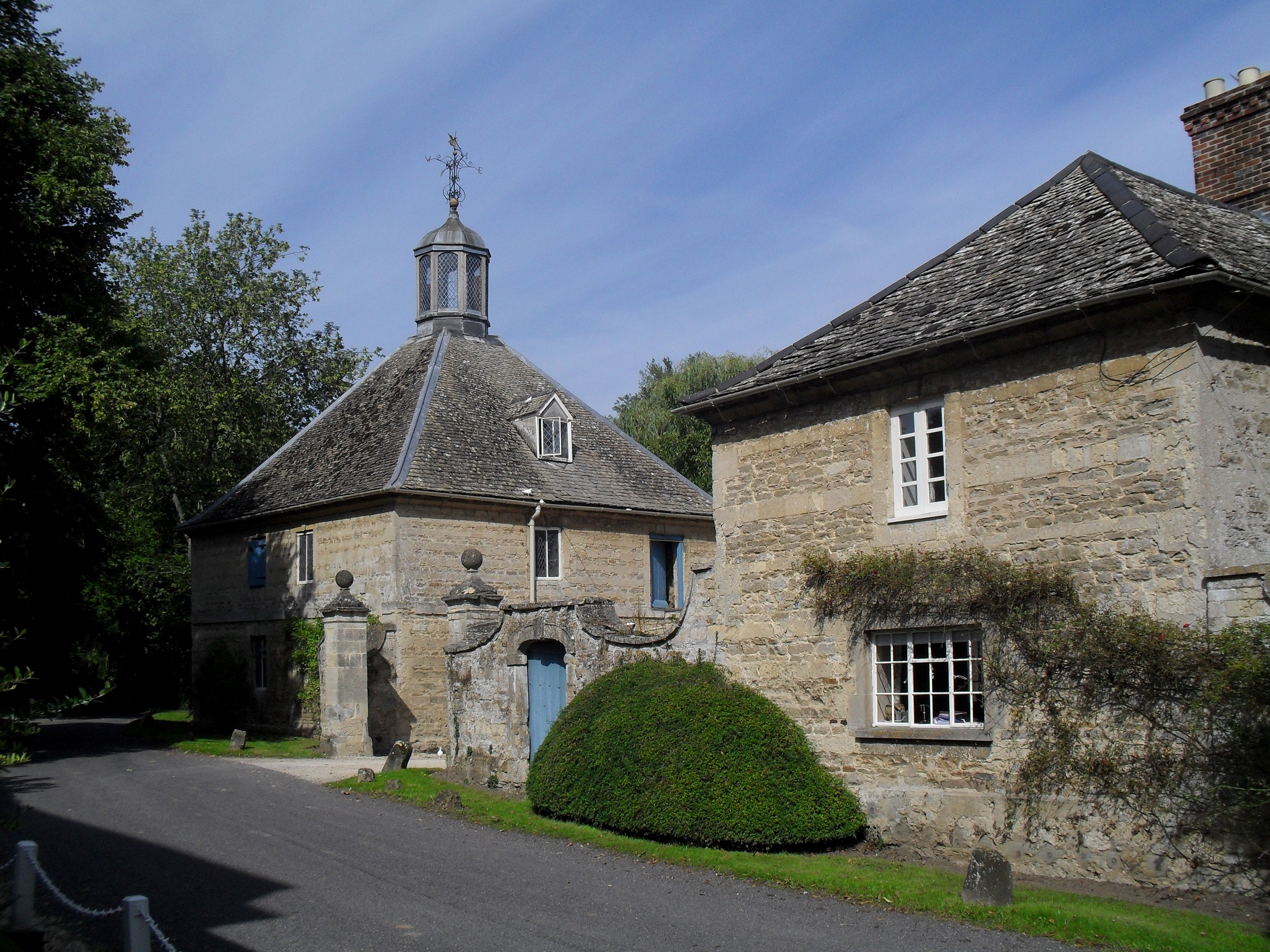
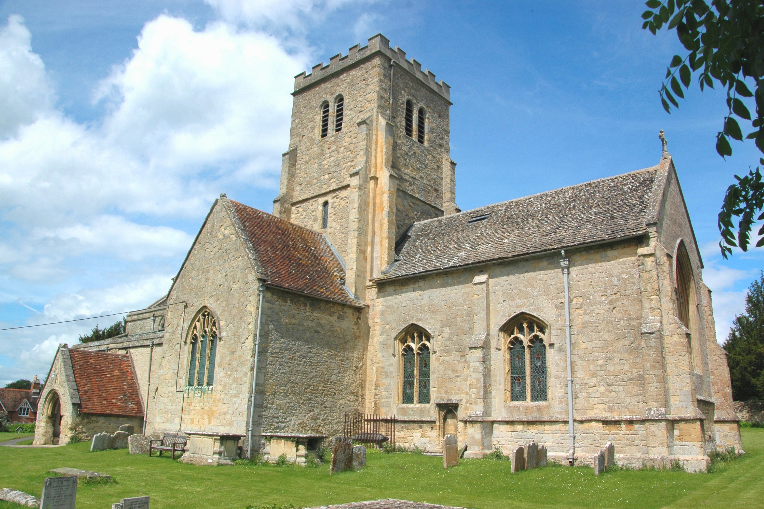
Cuddesdon is a picturesque village with a rich history dating back to the medieval period. It is well-known for being the location of the theological college, Ripon College Cuddesdon, which was founded in 1853 and is affiliated with the University of Oxford. The college's impressive buildings, including the chapel and the principal's lodge, add to the charm of the village. Cuddesdon also has a village church, St. Mary's Church, which is a Grade I listed building and features beautiful stained glass windows.

Denton, on the other hand, is a smaller village with a more rural feel. It is surrounded by rolling countryside and offers stunning views of the Chiltern Hills. The village is known for its charming thatched cottages and traditional English country gardens. Denton also has a village pub, The Mole Inn, which is popular among locals and visitors alike.

Both villages in Cuddesdon and Denton benefit from their close proximity to Oxford, making them attractive places to live for those who work in the city but prefer a quieter, more rural lifestyle. The parish offers a range of amenities, including local shops, schools, and community centers, making it a vibrant and welcoming community.

If you have any feedback on the listing, please let us know in the comments section below.

Cuddesdon and Denton Images

Images are sourced within 2km of 51.718239/-1.133996 or Grid Reference SP5902. Thanks to Geograph Open Source API. All images are credited.

Farmland, Great Milton A crop of beans with a building on the Wheatley campus of Oxford Brookes University seen in the background.
Farmland, Great Milton
A crop of beans with a building on the Wheatley campus of Oxford Brookes University seen in the background.
Pasture, Great Milton A footpath crosses damp grassland beside the River Thame with arable land rising beyond.
Pasture, Great Milton
A footpath crosses damp grassland beside the River Thame with arable land rising beyond.
Farmland, Cuddesdon A footpath descending through wheat to the east of the village.  The mast at Stokenchurch can be seen in the background atop the Chilterns.
Farmland, Cuddesdon
A footpath descending through wheat to the east of the village. The mast at Stokenchurch can be seen in the background atop the Chilterns.
Farmland, Cuddesdon A crop of barley to the south of the village is close to coming into flower.
Farmland, Cuddesdon
A crop of barley to the south of the village is close to coming into flower.
Farmland, Little Milton Broadwater Planting and fields of wheat on ground rising to the east of the River Thame.
Farmland, Little Milton
Broadwater Planting and fields of wheat on ground rising to the east of the River Thame.
River Thame from Cuddesdon Mill Bridge
Farmland, Little Milton A crop of wheat to the south of The Jenet.
Farmland, Little Milton
A crop of wheat to the south of The Jenet.
Farmland, Little Milton Fields of wheat to the south and west of Broadwater Planting.
Farmland, Little Milton
Fields of wheat to the south and west of Broadwater Planting.
Looking North
Looking North
Cuddesdon Mill
Cuddesdon Mill
All Saints Church, Cuddesdon
Entering Cuddesdon village Lane from Cuddesdon Mill up into Cuddesdon village
Entering Cuddesdon village
Lane from Cuddesdon Mill up into Cuddesdon village
Cuddesdon Lane View from the lane connecting Cuddesdon village with Cuddesdon Mill (centre right)
Views Farm on the Horizon.
Cuddesdon Lane
View from the lane connecting Cuddesdon village with Cuddesdon Mill (centre right) Views Farm on the Horizon.
Old bridge across Thame near Chippinghurst Manor
Old Bridge across River Thame looking towards Chippinghurst Manor
Cuddesdon Church
Cuddesdon Church
Hedge near Windmill Hill Fields and hedge West off the road to Little Milton near Windmill Hill
Hedge near Windmill Hill
Fields and hedge West off the road to Little Milton near Windmill Hill
The farm lane down to Warren Barn The farm lane down to Warren Barn near Windmill Hill
The farm lane down to Warren Barn
The farm lane down to Warren Barn near Windmill Hill
Show me another place!

Cuddesdon and Denton is located at Grid Ref: SP5902 (Lat: 51.718239, Lng: -1.133996)

Administrative County: Oxfordshire

District: South Oxfordshire

Police Authority: Thames Valley

What 3 Words

///adopters.meanwhile.twice. Near Garsington, Oxfordshire

Related Wikis

Denton, Oxfordshire

Denton is a hamlet and former civil parish, now in the parish of Cuddesdon and Denton, in the South Oxfordshire district, in Oxfordshire, England. Denton...

Cuddesdon

Cuddesdon is a mainly rural village and former civil parish, now in the parish of Cuddesdon and Denton, in the South Oxfordshire district, in the county...

Cuddesdon and Denton

Cuddesdon and Denton is a civil parish in the county of Oxfordshire, England. Forming part of South Oxfordshire district its main settlements are Cuddesdon...

Bishop Edward King Chapel

Bishop Edward King Chapel is the chapel of Ripon College Cuddesdon, a Church of England theological college near Oxford, and of the Sisters of the Communities...

Cuddesdon Palace

Cuddesdon Palace was the episcopal palace for the Bishop of Oxford, located near the village of Cuddesdon, Oxfordshire, England. == History == Cuddesdon...

Waterstock House Training Centre

Waterstock House Training Centre (WHTC) is situated in the village of Waterstock in Oxfordshire, England. It is a well used venue for local and national...

Oxford Centre for Ecclesiology and Practical Theology

The Oxford Centre for Ecclesiology and Practical Theology (OxCEPT) is a research centre based at Ripon College Cuddesdon. == Overview == OxCEPT was founded...

Ripon College Cuddesdon

Ripon College Cuddesdon is a Church of England theological college in Cuddesdon, a village 5.5 miles (8.9 km) outside Oxford, England. The College trains...

Nearby Amenities

Located within 500m of 51.718239,-1.133996
Pub
Bat and Ball
Accommodation: yes
Food: yes
Source: photograph
Lat/Long: 51.7219619/-1.1346098
Denton
Place: hamlet
Wikidata: Q5259584
Wikipedia: en:Denton, Oxfordshire
Lat/Long: 51.7184785/-1.1394001
Post Box
Ref: OX44 101
Source: photograph
Lat/Long: 51.7182251/-1.1394605
Note: sign marking boundary of place
Source: photograph;gps_survey
Lat/Long: 51.7207683/-1.1358003
Post Box
Brand: Royal Mail
Brand Wikidata: Q638098
Collection Times: Mo-Fr 16:30; Sa 09:30
Mapillary: 770611217178398
Operator: Royal Mail
Operator Wikidata: Q638098
Post Box Mounting: pier
Post Box Type: lamp
Ref: OX44 235
Source: photograph
Survey Date: 2020-10-25
Lat/Long: 51.7215973/-1.1357329
Phone: +44 1865 874386
Removed Amenity: telephone
Source: photograph
Lat/Long: 51.7219625/-1.1351541
Barrier: stile
Lat/Long: 51.7182627/-1.1405855
Bench
Created By: Potlatch 0.10f
Lat/Long: 51.7184435/-1.1399331
Barrier: stile
Lat/Long: 51.7174491/-1.139298
Barrier: stile
Lat/Long: 51.7181191/-1.1332813
Barrier: stile
Lat/Long: 51.7193794/-1.1270757
Barrier: stile
Ele: 64.774048
Lat/Long: 51.7175129/-1.1394267
Bus Stop
High Street
Bus: yes
Naptan AtcoCode: 340001975GRN
Naptan Bearing: SW
Naptan CommonName: High Street
Naptan Indicator: The Green Corner
Naptan Landmark: The Green
Naptan NaptanCode: oxfgjtdt
Naptan Street: High Street
Public Transport: platform
Route Ref: 103;104
Source: naptan_import;survey
Lat/Long: 51.722562/-1.1335636
Bus Stop
Cuddeston Green
Bus: yes
Naptan AtcoCode: 340001975VHL
Naptan Bearing: NE
Naptan CommonName: High Street
Naptan Indicator: Opp Village Hall
Naptan Landmark: The Green
Naptan NaptanCode: oxfawtdg
Naptan Street: High Street
Public Transport: platform
Route Ref: 103;104
Source: naptan_import
Lat/Long: 51.7219314/-1.1352477
Castle Farm
Naptan AtcoCode: 340001976OUT
Naptan Bearing: SW
Naptan BusStopType: CUS
Naptan CommonName: Castle Farm
Naptan Indicator: Outside
Naptan Landmark: Castle Farmhouse
Naptan NaptanCode: oxfawtda
Naptan Notes: Case Only
Naptan Street: Denton Hill
Naptan Verified: no
Source: naptan_import
Lat/Long: 51.7182316/-1.1393049
Bus Stop
Castle Farm
Bus: yes
Naptan AtcoCode: 340001976VIL
Naptan Bearing: NE
Naptan CommonName: Castle Farm
Naptan Indicator: Opposite
Naptan Landmark: Castle Farmhouse
Naptan NaptanCode: oxfgjtgw
Naptan Notes: Case Only
Naptan Street: Denton Hill
Public Transport: platform
Route Ref: 104
Source: naptan_import;survey
Lat/Long: 51.7183962/-1.139252
Barrier: stile
Lat/Long: 51.7208378/-1.136307
Barrier: stile
Lat/Long: 51.7203377/-1.1385654
Leisure: playground
Lat/Long: 51.7215299/-1.1354644
The data included in this document is from www.openstreetmap.org. The data is made available under ODbL.

Have you been to Cuddesdon and Denton?

Leave your review of Cuddesdon and Denton below (or comments, questions and feedback).