Baslow and Bubnell

Civil Parish in Derbyshire Derbyshire Dales

England

Baslow and Bubnell

Parallel roads near Robin Hood The A619 is just over the hedge to the right, as both roads climb up the valley of Heathy Lea Brook.
Parallel roads near Robin Hood Credit: Bill Boaden

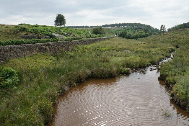
Baslow and Bubnell is a civil parish located in the county of Derbyshire in England. Situated in the Peak District National Park, it covers an area of approximately 14 square kilometers and is home to a population of around 1,500 people.

The parish is made up of two main villages, Baslow and Bubnell, which are located on the River Derwent. Baslow, the larger of the two, is a picturesque village known for its stunning natural surroundings and charming stone-built houses. It is a popular tourist destination, attracting visitors with its historic buildings, quaint shops, and traditional pubs. The village is also famous for its proximity to Chatsworth House, one of England's most magnificent stately homes.

Bubnell, a smaller village, is located just south of Baslow and is known for its tranquil and rural setting. It offers a peaceful retreat for residents and visitors alike, with its beautiful countryside and scenic views.

The parish is well-connected, with good transport links to nearby towns and cities, including Sheffield and Chesterfield. It also benefits from a range of amenities, including schools, shops, and healthcare facilities, making it an attractive place to live.

Baslow and Bubnell are surrounded by stunning natural landscapes, including the rugged moorlands, rolling hills, and wooded valleys of the Peak District National Park. This makes it an ideal location for outdoor activities such as hiking, cycling, and horse riding.

Overall, Baslow and Bubnell, Derbyshire, offer a delightful blend of natural beauty, historic charm, and modern convenience, making it a sought-after place to live and visit in the heart of the Peak District.

If you have any feedback on the listing, please let us know in the comments section below.

Baslow and Bubnell Images

Images are sourced within 2km of 53.249544/-1.606236 or Grid Reference SK2672. Thanks to Geograph Open Source API. All images are credited.

Parallel roads near Robin Hood The A619 is just over the hedge to the right, as both roads climb up the valley of Heathy Lea Brook.
Parallel roads near Robin Hood
The A619 is just over the hedge to the right, as both roads climb up the valley of Heathy Lea Brook.
Path below Birchen Edge The edge is up to the right, but this path does not make any attempt to get to the top.
Path below Birchen Edge
The edge is up to the right, but this path does not make any attempt to get to the top.
Rough farmland above Robin Hood Farm The land under Birchen Edge can only be used for grazing. The valley continues down towards Baslow.
Rough farmland above Robin Hood Farm
The land under Birchen Edge can only be used for grazing. The valley continues down towards Baslow.
Path below Birchen Edge There is quite a lot of foliage restricting views.
Path below Birchen Edge
There is quite a lot of foliage restricting views.
Farmland below Birchen Edge Moorside Farm is mostly hidden behind a wall.
Farmland below Birchen Edge
Moorside Farm is mostly hidden behind a wall.
Birchen Edge Seen from a path which runs below the edge.
Birchen Edge
Seen from a path which runs below the edge.
Boulder below Birchen Edge An erratic a short distance from the rocks of Birchen Edge.
Boulder below Birchen Edge
An erratic a short distance from the rocks of Birchen Edge.
Trig point on Birchen Edge There are views from the edge to Froggatt Edge and White Edge.
Trig point on Birchen Edge
There are views from the edge to Froggatt Edge and White Edge.
Birchen Edge Near the northern end of Birchen Edge.
Birchen Edge
Near the northern end of Birchen Edge.
Moorland above Birchen Edge A large plateau at around 300 metres above sea level.
Moorland above Birchen Edge
A large plateau at around 300 metres above sea level.
Path off Birchen Edge The northern end where the edge fades away. The A621 can be seen ahead climbing onto Ramsley Moor.
Path off Birchen Edge
The northern end where the edge fades away. The A621 can be seen ahead climbing onto Ramsley Moor.
Path up to Birchen Edge The edge is off to the right and the path approaches it from the northern end. The going on this path was fine in summer, but I would not fancy it in winter when I imagine it would be extremely soggy.
Path up to Birchen Edge
The edge is off to the right and the path approaches it from the northern end. The going on this path was fine in summer, but I would not fancy it in winter when I imagine it would be extremely soggy.
Path down to Clodhall Lane The path descends from Birchen Edge on ground that has the potential to be very soggy. The valley of Bar Brook is ahead.
Path down to Clodhall Lane
The path descends from Birchen Edge on ground that has the potential to be very soggy. The valley of Bar Brook is ahead.
Bar Brook Looking downstream from Clodhall Lane. The A621 is above the retaining wall. Gardom's Edge develops in the background.
Bar Brook
Looking downstream from Clodhall Lane. The A621 is above the retaining wall. Gardom's Edge develops in the background.
Clodhall Lane A long straight moorland road, here descending to the valley of Bar Brook and a junction with the A621.
Clodhall Lane
A long straight moorland road, here descending to the valley of Bar Brook and a junction with the A621.
Long wall above Blackstone Edge The wall lines a long distance of the track. On the other side, there are fields maintained by Gorse Bank Farm as a conservation area.
Long wall above Blackstone Edge
The wall lines a long distance of the track. On the other side, there are fields maintained by Gorse Bank Farm as a conservation area.
Cattle above Blackstone Edge The dip just beyond the cattle is the valley of Bar Brook. Birchen Edge is in the background.
Cattle above Blackstone Edge
The dip just beyond the cattle is the valley of Bar Brook. Birchen Edge is in the background.
Barley field on Eaglestone Flat Part of an area of farmland above Baslow Edge.
Barley field on Eaglestone Flat
Part of an area of farmland above Baslow Edge.
Show me another place!

Baslow and Bubnell is located at Grid Ref: SK2672 (Lat: 53.249544, Lng: -1.606236)

Administrative County: Derbyshire

District: Derbyshire Dales

Police Authority: Derbyshire

What 3 Words

///anthems.outbursts.gifts. Near Baslow, Derbyshire

Related Wikis

Gardom's Edge

Gardom's Edge is a rocky outcrop near Baslow in Derbyshire, England. The shelf between Gardom's Edge and Birchen Edge is now moorland used for grazing...

Baslow

Baslow is a village in Derbyshire, England, in the Peak District, situated between Sheffield and Bakewell, just over 1 mile (1.6 km) north of Chatsworth...

St Anne's Church, Baslow

St. Anne’s Church, Baslow, is a Grade II* listed parish church in Baslow, England. == History == The church dates from the thirteenth century. It was subject...

Baslow Hall

Baslow Hall is a Grade II listed building in Baslow, Derbyshire. == History == Baslow Hall, just off Calver Road, was built in 1907 to the designs of the...
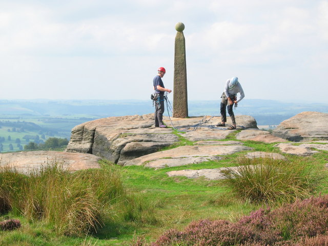
Birchen Edge

Birchen Edge is a gritstone rock face in the Peak District, England, popular with walkers and novice climbers as most of the climbing routes are in the...

Cliff College

Cliff College is a Christian theological college in Calver, Derbyshire, that teaches Biblical Theology at the undergraduate level and a number of mission...

Curbar

Curbar is a village and civil parish in the Derbyshire Dales district of Derbyshire, England. The population based on the 2011 Census was 417. Curbar is...
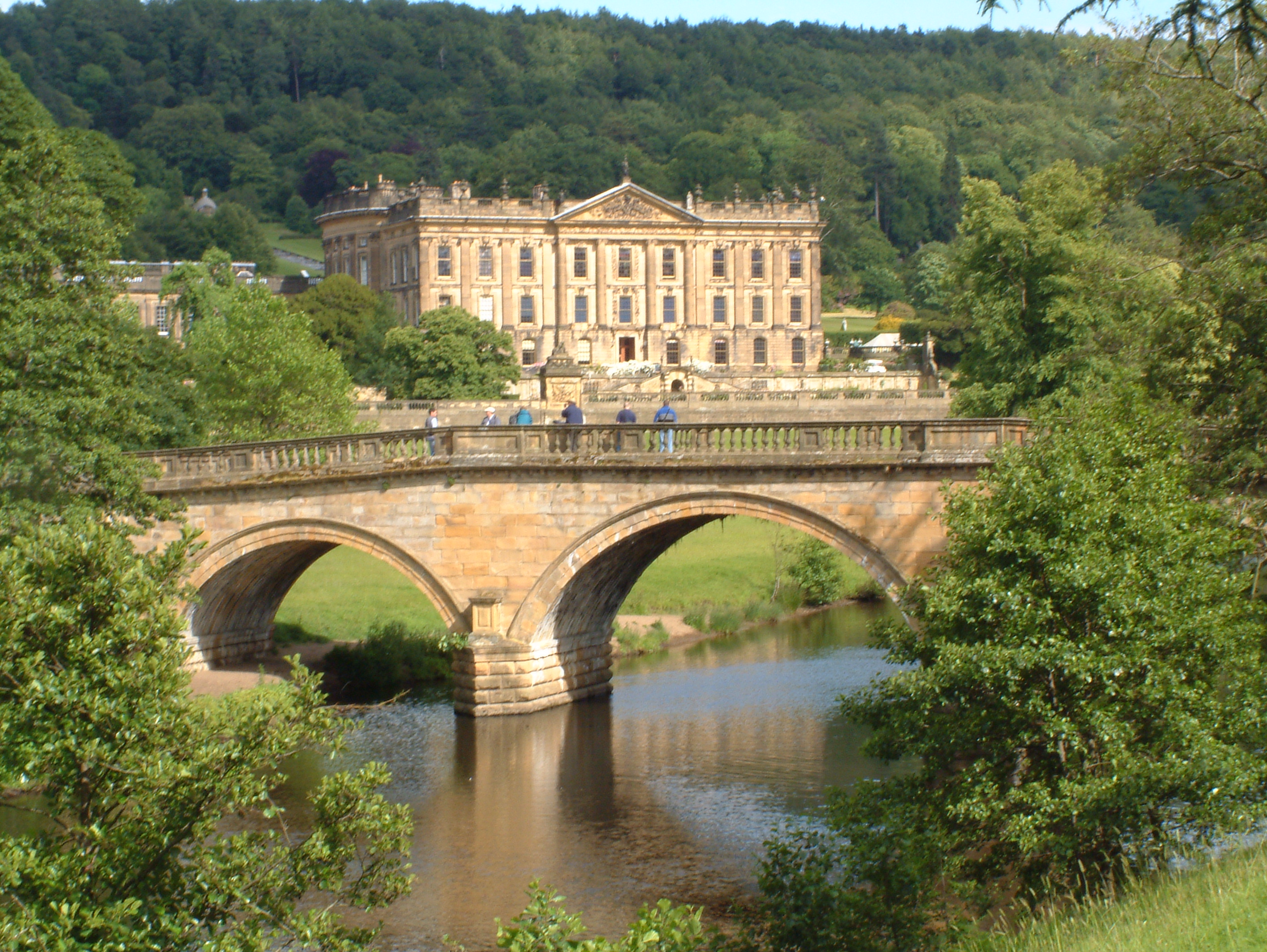
Chatsworth House

Chatsworth House is a stately home in the Derbyshire Dales, 4 miles (6.4 km) north-east of Bakewell and 9 miles (14 km) west of Chesterfield, England....

Nearby Amenities

Located within 500m of 53.249544,-1.606236
Barrier: stile
Material: wood
Source: survey;gps
Stile: stepover
Lat/Long: 53.2494584/-1.6089565
Barrier: stile
Material: stone
Source: survey;gps
Stile: stepover
Lat/Long: 53.2473001/-1.6050902
Barrier: stile
Material: stone
Source: survey;gps
Stile: stepover
Lat/Long: 53.2484115/-1.607405
Bus Stop
Baslow (Golden Gates)
Bus: yes
Naptan AtcoCode: 100000021969
Naptan NaptanCode: dbsgpdap
Public Transport: platform
Lat/Long: 53.2471727/-1.6097981
Baslow (Golden Gates)
Bus: yes
Public Transport: stop_position
Lat/Long: 53.2472154/-1.6098404
Bus Stop
Baslow (Golden Gates)
Bus: yes
Naptan AtcoCode: 100000021964
Naptan NaptanCode: dbsgpdaj
Public Transport: platform
Lat/Long: 53.2472658/-1.6097968
Baslow (Golden Gates)
Bus: yes
Public Transport: stop_position
Lat/Long: 53.2472417/-1.6097701
Historic Operator: Derwent Valley Water Board
Operator: Severnt Trent Water
Pipeline: valve
Lat/Long: 53.251177/-1.6121845
Historic Operator: Derwent Valley Water Board
Operator: Severnt Trent Water
Pipeline: valve
Lat/Long: 53.2511896/-1.6121582
Historic Operator: Derwent Valley Water Board
Operator: Severn Trent Water
Pipeline: valve
Lat/Long: 53.2457022/-1.6085119
Historic Operator: Derwent Valley Water Board
Operator: Severn Trent Water
Pipeline: valve
Lat/Long: 53.2457074/-1.6085613
The data included in this document is from www.openstreetmap.org. The data is made available under ODbL.

Have you been to Baslow and Bubnell?

Leave your review of Baslow and Bubnell below (or comments, questions and feedback).