Bassenthwaite

Civil Parish in Cumberland Allerdale

England

Bassenthwaite

Gates near Peter House Farm The public bridleway from Skiddaw House to Bassenthwaite and the low level alternative route of The Cumbria Way cross the road here (next photograph <a href="https://www.geograph.org.uk/photo/7112133">NY2432 : Gate and Stile near Peter House Farm</a>).
Gates near Peter House Farm Credit: Adrian Taylor

Bassenthwaite is a civil parish located in the county of Cumberland, in the northwest region of England. Situated in the picturesque Lake District National Park, it covers an area of approximately 22 square kilometers and is bordered by the towns of Keswick to the south and Cockermouth to the north.

The parish is named after Bassenthwaite Lake, which is the only body of water in the Lake District that is officially called a lake. It is a popular tourist destination, attracting visitors from around the world who come to admire its stunning natural beauty and enjoy a variety of outdoor activities such as boating, fishing, and walking.

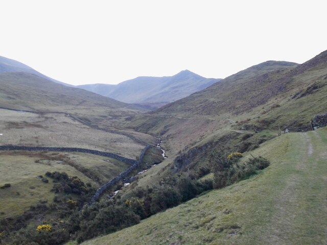
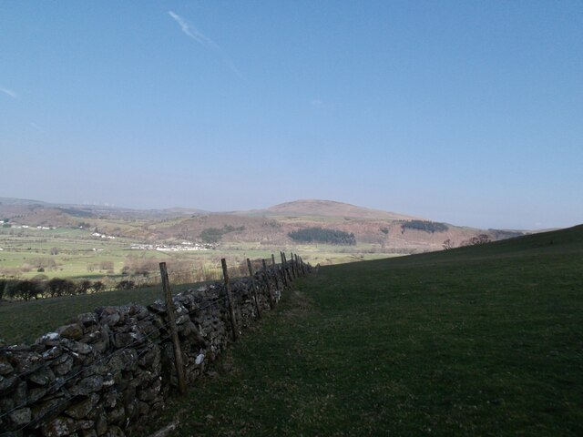
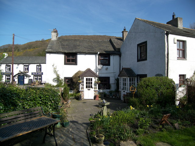
The area is characterized by its rolling hills, lush green valleys, and picturesque villages. It is home to a small population, with the main village being Bassenthwaite, which is located on the eastern shores of the lake. The village features a charming church, a few traditional cottages, and a handful of amenities including a pub and a tearoom.

Bassenthwaite is also known for its rich wildlife, with the lake and surrounding woodlands providing a habitat for a variety of bird species, including ospreys, which nest in the area during the summer months. The nearby Dodd Wood is a popular spot for birdwatching and offers stunning views of the surrounding countryside.

Overall, Bassenthwaite is a tranquil and idyllic part of the Lake District, offering visitors a chance to experience the beauty of nature in a peaceful and unspoiled setting.

If you have any feedback on the listing, please let us know in the comments section below.

Bassenthwaite Images

Images are sourced within 2km of 54.668854/-3.186941 or Grid Reference NY2331. Thanks to Geograph Open Source API. All images are credited.

Gates near Peter House Farm The public bridleway from Skiddaw House to Bassenthwaite and the low level alternative route of The Cumbria Way cross the road here (next photograph <a href="https://www.geograph.org.uk/photo/7112133">NY2432 : Gate and Stile near Peter House Farm</a>).
Gates near Peter House Farm
The public bridleway from Skiddaw House to Bassenthwaite and the low level alternative route of The Cumbria Way cross the road here (next photograph NY2432 : Gate and Stile near Peter House Farm).
The Cumbria Way near Peter House Farm The Cumbria Way low level alternative route from Skiddaw House to Caldbeck follows the Dash Farm access road on the approach to Peter House Farm.  The access road is the also the public bridleway from Skiddaw House to Bassenthwaite and the only vehicular access to Skiddaw House Youth Hostel (next photograph <a href="https://www.geograph.org.uk/photo/7097243">NY2432 : Gates near Peter House Farm</a>).
The Cumbria Way near Peter House Farm
The Cumbria Way low level alternative route from Skiddaw House to Caldbeck follows the Dash Farm access road on the approach to Peter House Farm. The access road is the also the public bridleway from Skiddaw House to Bassenthwaite and the only vehicular access to Skiddaw House Youth Hostel (next photograph NY2432 : Gates near Peter House Farm).
Farm access road near Springsyke The road is a public bridleway and the route of The Cumbria Way low level alternative route from Skiddaw House to Caldbeck (next photograph <a href="https://www.geograph.org.uk/photo/7097246">NY2432 : The Cumbria Way near Peter House Farm</a>).
Farm access road near Springsyke
The road is a public bridleway and the route of The Cumbria Way low level alternative route from Skiddaw House to Caldbeck (next photograph NY2432 : The Cumbria Way near Peter House Farm).
Farm access road near Springsyke The road provides access to Dash Farm and Skiddaw House.  It is the low level alternative route of The Cumbria Way between Skiddaw House and Caldbeck (next photograph <a href="https://www.geograph.org.uk/photo/7097251">NY2532 : Farm access road near Springsyke</a>).
The fell in the background is Binsey; the northernmost of the Wainwrights (photograph <a href="https://www.geograph.org.uk/photo/7582811">NY2233 : Binsey</a>).
Farm access road near Springsyke
The road provides access to Dash Farm and Skiddaw House. It is the low level alternative route of The Cumbria Way between Skiddaw House and Caldbeck (next photograph NY2532 : Farm access road near Springsyke). The fell in the background is Binsey; the northernmost of the Wainwrights (photograph NY2233 : Binsey).
Gate near Springsyke The gated access road is the route of The Cumbria Way low level alternative route from Skiddaw House to Caldbeck (next photograph <a href="https://www.geograph.org.uk/photo/7097255">NY2532 : Farm access road near Springsyke</a>).
Gate near Springsyke
The gated access road is the route of The Cumbria Way low level alternative route from Skiddaw House to Caldbeck (next photograph NY2532 : Farm access road near Springsyke).
Bridleway near Peter House Farm This track is the public bridleway from Peter House Farm to Bassenthwaite and also the low level alternative route of The Cumbria Way from Skiddaw House to Nether Row near Caldbeck (next photograph <a href="https://www.geograph.org.uk/photo/7139220">NY2432 : The Cumbria Way near Peter House Farm</a>).
The rushes indicate that this part of the field is inclined to be boggy.
Bridleway near Peter House Farm
This track is the public bridleway from Peter House Farm to Bassenthwaite and also the low level alternative route of The Cumbria Way from Skiddaw House to Nether Row near Caldbeck (next photograph NY2432 : The Cumbria Way near Peter House Farm). The rushes indicate that this part of the field is inclined to be boggy.
Pasture near Peter House Farm This pasture field is crossed by the public bridleway from Peter House Farm to Bassenthwaite, which is also the low level alternative route of The Cumbria Way.
Northbound walkers on The Cumbria Way will pick up a track between the rushes in the background on the approach to a gate, hidden behind the trees (next photograph <a href="https://www.geograph.org.uk/photo/7112115">NY2432 : Bridleway near Peter House Farm</a>).
Pasture near Peter House Farm
This pasture field is crossed by the public bridleway from Peter House Farm to Bassenthwaite, which is also the low level alternative route of The Cumbria Way. Northbound walkers on The Cumbria Way will pick up a track between the rushes in the background on the approach to a gate, hidden behind the trees (next photograph NY2432 : Bridleway near Peter House Farm).
The Cumbria Way near Peter House Farm This field is crossed by the public bridleway from Peter House Farm to Bassenthwaite, which is also the low level alternative route of The Cumbria Way.
The obvious track is a farm track; the bridleway is not visible on the ground and northbound walkers on The Cumbria Way should cross the field in the direction of the right hand end of the clump of trees (next photograph <a href="https://www.geograph.org.uk/photo/7362844">NY2432 : Field near Peter House Farm</a>).
The Cumbria Way near Peter House Farm
This field is crossed by the public bridleway from Peter House Farm to Bassenthwaite, which is also the low level alternative route of The Cumbria Way. The obvious track is a farm track; the bridleway is not visible on the ground and northbound walkers on The Cumbria Way should cross the field in the direction of the right hand end of the clump of trees (next photograph NY2432 : Field near Peter House Farm).
Gate and Stile near Peter House Farm The stile, almost hidden by the grass and nettles at the end of the hedge, is the alternative route of The Cumbria Way from Skiddaw house to Nether Row near Caldbeck.  Beyond the stile the route follows a public bridleway across the field (next photograph <a href="https://www.geograph.org.uk/photo/7112131">NY2432 : The Cumbria Way near Peter House Farm</a>).
Gate and Stile near Peter House Farm
The stile, almost hidden by the grass and nettles at the end of the hedge, is the alternative route of The Cumbria Way from Skiddaw house to Nether Row near Caldbeck. Beyond the stile the route follows a public bridleway across the field (next photograph NY2432 : The Cumbria Way near Peter House Farm).
Peter House Farm
Peter House Farm
Southerndale
Southerndale
Wall in the shadow of the hills looking north
Grazing on Barkbeth Hill
Bridleway near Peter House Farm The public bridleway from Melbecks to Halls Beck and Whitefield Wood runs beside a shelter belt of trees.  It is the low level alternative route of The Cumbria Way from Skiddaw House to Nether Row near Caldbeck (next photograph <a href="https://www.geograph.org.uk/photo/7140438">NY2432 : Field Gate on The Cumbria Way</a>).
Bridleway near Peter House Farm
The public bridleway from Melbecks to Halls Beck and Whitefield Wood runs beside a shelter belt of trees. It is the low level alternative route of The Cumbria Way from Skiddaw House to Nether Row near Caldbeck (next photograph NY2432 : Field Gate on The Cumbria Way).
Bridleways near Peter House Farm Two public bridleways cross here.  Straight ahead the bridleway from Keswick via Skiddaw House and Peter House Farm continues to Bassenthwaite village.  Crossing it is the bridleway from Melbecks to Halls Beck and Whitefield Wood.
Northbound walkers following The Cumbria Way turn right here (next photograph <a href="https://www.geograph.org.uk/photo/7133329">NY2432 : Bridleway near Peter House Farm</a>).
Bridleways near Peter House Farm
Two public bridleways cross here. Straight ahead the bridleway from Keswick via Skiddaw House and Peter House Farm continues to Bassenthwaite village. Crossing it is the bridleway from Melbecks to Halls Beck and Whitefield Wood. Northbound walkers following The Cumbria Way turn right here (next photograph NY2432 : Bridleway near Peter House Farm).
Bridleway gate near Peter House Farm The gate is on the public bridleway from Peter House Farm to Bassenthwaite; it is the low level alternative route of The Cumbria Way long distance path (next photograph <a href="https://www.geograph.org.uk/photo/7139201">NY2432 : Bridleways near Peter House Farm</a>).
Bridleway gate near Peter House Farm
The gate is on the public bridleway from Peter House Farm to Bassenthwaite; it is the low level alternative route of The Cumbria Way long distance path (next photograph NY2432 : Bridleways near Peter House Farm).
The Cumbria Way near Peter House Farm The Cumbria Way low level alternative route from Skiddaw House to Nether Row near Caldbeck follows a public bridleway through farm land near Peter House Farm (next photograph <a href="https://www.geograph.org.uk/photo/7139209">NY2432 : Bridleway gate near Peter House Farm</a>).
The Cumbria Way near Peter House Farm
The Cumbria Way low level alternative route from Skiddaw House to Nether Row near Caldbeck follows a public bridleway through farm land near Peter House Farm (next photograph NY2432 : Bridleway gate near Peter House Farm).
Field Gate on The Cumbria Way This field gate near High Close is on the low level alternative route of The Cumbria Way between Skiddaw House and Caldbeck (next photograph <a href="https://www.geograph.org.uk/photo/7140428">NY2432 : Gate on The Cumbria Way, High Close</a>).
Field Gate on The Cumbria Way
This field gate near High Close is on the low level alternative route of The Cumbria Way between Skiddaw House and Caldbeck (next photograph NY2432 : Gate on The Cumbria Way, High Close).
Show me another place!

Bassenthwaite is located at Grid Ref: NY2331 (Lat: 54.668854, Lng: -3.186941)

Administrative County: Cumbria

District: Allerdale

Police Authority: Cumbria

What 3 Words

///plugs.shared.summaries. Near Keswick, Cumbria

Related Wikis

Chapel, Cumbria

Chapel is a hamlet in the English county of Cumbria. Chapel is located on the A591 road between Bassenthwaite and Bassenthwaite Lake. The Cumbria Way crosses...

St Bega's Way

St Bega's Way is a 36-mile (58 km) walk through rural West Cumbria and the north west corner of the English Lake District. It is usually completed as a...

Bassenthwaite

Bassenthwaite is a village and civil parish to the west of Bassenthwaite Lake in Cumbria, historically part of Cumberland, within the Lake District National...

Bassenfell Manor

Bassenfell Manor is a manor house in Bassenthwaite, Cumbria, overlooking Bassenthwaite Lake in England's Lake District. It is used as a Christian residential...

Ullock Pike

Ullock Pike is a fell situated in northern part of the English Lake District. It is located seven kilometres north west of Keswick and achieves a height...

Mirehouse

Mirehouse is a 17th-century house to the north of Keswick in Cumbria, at the foot of Dodd, near Bassenthwaite Lake and St Bega's Church, on the A591 road...

Bassenthwaite Lake

Bassenthwaite Lake is a body of water in the Lake District in North West England, near the town of Keswick. It has an area of 5.3 km2 (2.0 sq mi), making...

Dash Valley

The Dash Valley is a small valley in the English Lake District. It has only one dwelling, Dash Farm, the fields of which spread right across the valley...

Nearby Amenities

Located within 500m of 54.668854,-3.186941
Post Box
Brand: Royal Mail
Brand Wikidata: Q638098
Mapillary: 227078453499826
Operator: Royal Mail
Operator Wikidata: Q638098
Post Box Mounting: pier
Post Box Type: lamp
Ref: CA12 203
Royal Cypher: EIIR
Royal Cypher Wikidata: Q33102113
Survey Date: 2023-05-23
Lat/Long: 54.665154/-3.1880564
Bus Stop
High Side (S bound)
Bench: no
Bus: yes
Covered: no
Local Ref: AT
Naptan AtcoCode: 090002050611
Naptan Bearing: S
Naptan CommonName: High Side (S bound)
Naptan Indicator: at
Naptan Landmark: Junction to Orthwaite
Naptan NaptanCode: cumdmwaw
Naptan Street: A591
Naptan Verified: yes
Public Transport: platform
Shelter: no
Source: naptan_import
Lat/Long: 54.6650005/-3.1879574
High Side Farm (N bound)
Naptan AtcoCode: 090002053444
Naptan Bearing: N
Naptan BusStopType: CUS
Naptan CommonName: High Side Farm (N bound)
Naptan Indicator: n/bound
Naptan Landmark: At junction to Orthwaite
Naptan NaptanCode: cumdmwdw
Naptan Street: A591
Naptan Verified: yes
Source: naptan_import
Lat/Long: 54.6650066/-3.1882522
Barrier: stile
Lat/Long: 54.6724637/-3.1837091
Highside Farm B&B
Addr Postcode: CA12 4QG
Internet Access: yes
Internet Access Fee: no
Phone: +44 1768 776952
Tourism: guest_house
Website: https://highside.co.uk/
Lat/Long: 54.6647866/-3.1877713
Barrier: stile
Lat/Long: 54.6700695/-3.1799088
Power: pole
Lat/Long: 54.6706519/-3.1841957
Power: pole
Lat/Long: 54.6697495/-3.183507
Power: pole
Lat/Long: 54.6688315/-3.1846866
Power: pole
Lat/Long: 54.6679977/-3.1857322
Power: pole
Lat/Long: 54.6671753/-3.1866917
Power: pole
Lat/Long: 54.6666474/-3.186898
Power: pole
Lat/Long: 54.6656361/-3.1868404
Power: pole
Lat/Long: 54.6647918/-3.1870738
Power: pole
Lat/Long: 54.6700019/-3.193188
Power: pole
Lat/Long: 54.6700433/-3.1941106
The data included in this document is from www.openstreetmap.org. The data is made available under ODbL.

Have you been to Bassenthwaite?

Leave your review of Bassenthwaite below (or comments, questions and feedback).