All Cannings
Civil Parish in Wiltshire
England
All Cannings

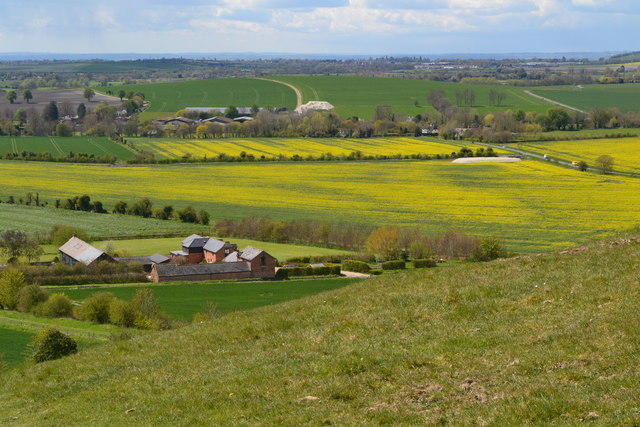
All Cannings is a civil parish located in Wiltshire, England. Situated in the Vale of Pewsey, it lies approximately 10 miles east of the historic town of Devizes. The village of All Cannings is the primary settlement within the parish, and it is surrounded by picturesque countryside.
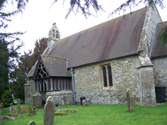
The village itself is characterized by its charming thatched cottages and traditional English countryside atmosphere. It has a close-knit community and a population of around 800 residents. The heart of the village is the All Saints Church, a beautiful medieval structure dating back to the 12th century. The church is known for its stunning stained glass windows and impressive architecture.
All Cannings benefits from a range of amenities, including a primary school, a village hall, and a post office. The village also has a pub, The Kings Arms, which serves as a popular gathering spot for locals and visitors alike.
The surrounding area offers plenty of opportunities for outdoor activities, with numerous footpaths and bridleways that allow residents to explore the stunning Wiltshire countryside. The Kennet and Avon Canal, which runs close to the village, is also a popular spot for walks and boating.
Overall, All Cannings is a picturesque and peaceful village that provides a charming rural lifestyle for its residents. Its rich history and beautiful surroundings make it an attractive destination for those seeking a quintessential English countryside experience.
If you have any feedback on the listing, please let us know in the comments section below.
All Cannings Images
Images are sourced within 2km of 51.357266/-1.901922 or Grid Reference SU0662. Thanks to Geograph Open Source API. All images are credited.
![A walk from Allington to the Wansdyke and back [1] The bridleway approaches the Kennet and Avon Canal.
The walk leaves Allington and goes south to run along the towpath of the Kennet and Avon Canal before turning north to cross the minor road at Cannings Cross. Ascending steeply, the path leads to the causewayed enclosure and hillfort of Rybury atop Clifford’s Hill. After a short descent, there is a long climb up Tan Hill to the Wansdyke. A short way along the dyke, the return journey starts, a long descent down a well surfaced track, a public bridleway, to Allington. Just over 4½ miles.](https://s1.geograph.org.uk/geophotos/07/36/37/7363773_f6531b1e.jpg)
![A walk from Allington to the Wansdyke and back [2] This swing bridge carries the bridleway over the Kennet and Avon Canal.
The walk leaves Allington and goes south to run along the towpath of the Kennet and Avon Canal before turning north to cross the minor road at Cannings Cross. Ascending steeply, the path leads to the causewayed enclosure and hillfort of Rybury atop Clifford’s Hill. After a short descent, there is a long climb up Tan Hill to the Wansdyke. A short way along the dyke, the return journey starts, a long descent down a well surfaced track, a public bridleway, to Allington. Just over 4½ miles.](https://s2.geograph.org.uk/geophotos/07/36/37/7363774_594bbe42.jpg)
![A walk from Allington to the Wansdyke and back [3] Boats along the Kennet and Avon Canal. Seen from the towpath.
The walk leaves Allington and goes south to run along the towpath of the Kennet and Avon Canal before turning north to cross the minor road at Cannings Cross. Ascending steeply, the path leads to the causewayed enclosure and hillfort of Rybury atop Clifford’s Hill. After a short descent, there is a long climb up Tan Hill to the Wansdyke. A short way along the dyke, the return journey starts, a long descent down a well surfaced track, a public bridleway, to Allington. Just over 4½ miles.](https://s3.geograph.org.uk/geophotos/07/36/37/7363775_6e5245be.jpg)
![A walk from Allington to the Wansdyke and back [4] 'Lest we forget' on a boat on the Kennet and Avon Canal.
The walk leaves Allington and goes south to run along the towpath of the Kennet and Avon Canal before turning north to cross the minor road at Cannings Cross. Ascending steeply, the path leads to the causewayed enclosure and hillfort of Rybury atop Clifford’s Hill. After a short descent, there is a long climb up Tan Hill to the Wansdyke. A short way along the dyke, the return journey starts, a long descent down a well surfaced track, a public bridleway, to Allington. Just over 4½ miles.](https://s2.geograph.org.uk/geophotos/07/36/37/7363778_0b0f2cf7.jpg)
![A walk from Allington to the Wansdyke and back [5] Perfectly reflected in the canal is Woodway Bridge. This accommodation bridge was built circa 1807 of brick with an oval arch. There is another image of the bridge at <a href="https://www.geograph.org.uk/photo/7363787">SU0762 : A walk from Allington to the Wansdyke and back [6]</a> Listed, grade II, with details at: <span class="nowrap"><a title="https://historicengland.org.uk/listing/the-list/list-entry/1033771" rel="nofollow ugc noopener" href="https://historicengland.org.uk/listing/the-list/list-entry/1033771">Link</a><img style="margin-left:2px;" alt="External link" title="External link - shift click to open in new window" src="https://s1.geograph.org.uk/img/external.png" width="10" height="10"/></span>
The walk leaves Allington and goes south to run along the towpath of the Kennet and Avon Canal before turning north to cross the minor road at Cannings Cross. Ascending steeply, the path leads to the causewayed enclosure and hillfort of Rybury atop Clifford’s Hill. After a short descent, there is a long climb up Tan Hill to the Wansdyke. A short way along the dyke, the return journey starts, a long descent down a well surfaced track, a public bridleway, to Allington. Just over 4½ miles.](https://s3.geograph.org.uk/geophotos/07/36/37/7363783_0583b20f.jpg)
![A walk from Allington to the Wansdyke and back [6] Woodway Bridge is an accommodation bridge built circa 1807 of brick with an oval arch. There is another image of the bridge at <a href="https://www.geograph.org.uk/photo/7363783">SU0762 : A walk from Allington to the Wansdyke and back [5]</a> Listed, grade II, with details at: <span class="nowrap"><a title="https://historicengland.org.uk/listing/the-list/list-entry/1033771" rel="nofollow ugc noopener" href="https://historicengland.org.uk/listing/the-list/list-entry/1033771">Link</a><img style="margin-left:2px;" alt="External link" title="External link - shift click to open in new window" src="https://s1.geograph.org.uk/img/external.png" width="10" height="10"/></span>
The walk leaves Allington and goes south to run along the towpath of the Kennet and Avon Canal before turning north to cross the minor road at Cannings Cross. Ascending steeply, the path leads to the causewayed enclosure and hillfort of Rybury atop Clifford’s Hill. After a short descent, there is a long climb up Tan Hill to the Wansdyke. A short way along the dyke, the return journey starts, a long descent down a well surfaced track, a public bridleway, to Allington. Just over 4½ miles.](https://s3.geograph.org.uk/geophotos/07/36/37/7363787_8bb1f32e.jpg)
![A walk from Allington to the Wansdyke and back [7] The long, straight path runs across the field towards Cannings Cross.
The walk leaves Allington and goes south to run along the towpath of the Kennet and Avon Canal before turning north to cross the minor road at Cannings Cross. Ascending steeply, the path leads to the causewayed enclosure and hillfort of Rybury atop Clifford’s Hill. After a short descent, there is a long climb up Tan Hill to the Wansdyke. A short way along the dyke, the return journey starts, a long descent down a well surfaced track, a public bridleway, to Allington. Just over 4½ miles.](https://s2.geograph.org.uk/geophotos/07/36/37/7363794_8d41863c.jpg)
![A walk from Allington to the Wansdyke and back [8] The long, straight path runs across the field towards Cannings Cross.
The walk leaves Allington and goes south to run along the towpath of the Kennet and Avon Canal before turning north to cross the minor road at Cannings Cross. Ascending steeply, the path leads to the causewayed enclosure and hillfort of Rybury atop Clifford’s Hill. After a short descent, there is a long climb up Tan Hill to the Wansdyke. A short way along the dyke, the return journey starts, a long descent down a well surfaced track, a public bridleway, to Allington. Just over 4½ miles.](https://s0.geograph.org.uk/geophotos/07/36/37/7363796_b1196d10.jpg)
![A walk from Allington to the Wansdyke and back [9] The path continues as a track at Cannings Cross.
The walk leaves Allington and goes south to run along the towpath of the Kennet and Avon Canal before turning north to cross the minor road at Cannings Cross. Ascending steeply, the path leads to the causewayed enclosure and hillfort of Rybury atop Clifford’s Hill. After a short descent, there is a long climb up Tan Hill to the Wansdyke. A short way along the dyke, the return journey starts, a long descent down a well surfaced track, a public bridleway, to Allington. Just over 4½ miles.](https://s0.geograph.org.uk/geophotos/07/36/38/7363800_53cd558d.jpg)
![A walk from Allington to the Wansdyke and back [10] Cottages and garages at Cannings Cross.
The walk leaves Allington and goes south to run along the towpath of the Kennet and Avon Canal before turning north to cross the minor road at Cannings Cross. Ascending steeply, the path leads to the causewayed enclosure and hillfort of Rybury atop Clifford’s Hill. After a short descent, there is a long climb up Tan Hill to the Wansdyke. A short way along the dyke, the return journey starts, a long descent down a well surfaced track, a public bridleway, to Allington. Just over 4½ miles.](https://s3.geograph.org.uk/geophotos/07/36/45/7364547_03e15912.jpg)
![A walk from Allington to the Wansdyke and back [11] After crossing the minor road at Cannings Cross, the route, now a bridleway, heads towards Clifford&#039;s Hill.
The walk leaves Allington and goes south to run along the towpath of the Kennet and Avon Canal before turning north to cross the minor road at Cannings Cross. Ascending steeply, the path leads to the causewayed enclosure and hillfort of Rybury atop Clifford’s Hill. After a short descent, there is a long climb up Tan Hill to the Wansdyke. A short way along the dyke, the return journey starts, a long descent down a well surfaced track, a public bridleway, to Allington. Just over 4½ miles.](https://s0.geograph.org.uk/geophotos/07/36/45/7364548_83059f84.jpg)
![A walk from Allington to the Wansdyke and back [12] The footpath branches off the bridleway and starts a steep ascent past the water trough and the covered reservoir.
The walk leaves Allington and goes south to run along the towpath of the Kennet and Avon Canal before turning north to cross the minor road at Cannings Cross. Ascending steeply, the path leads to the causewayed enclosure and hillfort of Rybury atop Clifford’s Hill. After a short descent, there is a long climb up Tan Hill to the Wansdyke. A short way along the dyke, the return journey starts, a long descent down a well surfaced track, a public bridleway, to Allington. Just over 4½ miles.](https://s1.geograph.org.uk/geophotos/07/36/45/7364549_e5555da9.jpg)
![A walk from Allington to the Wansdyke and back [13] Looking back down the path, past the covered reservoir to the water trough. The buildings of Cannings Cross and the Vale of Pewsey are beyond.
The walk leaves Allington and goes south to run along the towpath of the Kennet and Avon Canal before turning north to cross the minor road at Cannings Cross. Ascending steeply, the path leads to the causewayed enclosure and hillfort of Rybury atop Clifford’s Hill. After a short descent, there is a long climb up Tan Hill to the Wansdyke. A short way along the dyke, the return journey starts, a long descent down a well surfaced track, a public bridleway, to Allington. Just over 4½ miles.](https://s2.geograph.org.uk/geophotos/07/36/45/7364550_1c08bad5.jpg)
![A walk from Allington to the Wansdyke and back [14] The path follows the fence line.
The walk leaves Allington and goes south to run along the towpath of the Kennet and Avon Canal before turning north to cross the minor road at Cannings Cross. Ascending steeply, the path leads to the causewayed enclosure and hillfort of Rybury atop Clifford’s Hill. After a short descent, there is a long climb up Tan Hill to the Wansdyke. A short way along the dyke, the return journey starts, a long descent down a well surfaced track, a public bridleway, to Allington. Just over 4½ miles.](https://s3.geograph.org.uk/geophotos/07/36/45/7364551_9ce1bbdc.jpg)
![A walk from Allington to the Wansdyke and back [15] The line of the Right of Way is to the right but the path heads left.
The walk leaves Allington and goes south to run along the towpath of the Kennet and Avon Canal before turning north to cross the minor road at Cannings Cross. Ascending steeply, the path leads to the causewayed enclosure and hillfort of Rybury atop Clifford’s Hill. After a short descent, there is a long climb up Tan Hill to the Wansdyke. A short way along the dyke, the return journey starts, a long descent down a well surfaced track, a public bridleway, to Allington. Just over 4½ miles.](https://s0.geograph.org.uk/geophotos/07/36/45/7364552_f7b654e3.jpg)


All Cannings is located at Grid Ref: SU0662 (Lat: 51.357266, Lng: -1.901922)
Unitary Authority: Wiltshire
Police Authority: Wiltshire
What 3 Words
///herring.magpie.whiplash. Near Woodborough, Wiltshire
Nearby Locations
Related Wikis


Nearby Amenities
Located within 500m of 51.357266,-1.901922Have you been to All Cannings?
Leave your review of All Cannings below (or comments, questions and feedback).