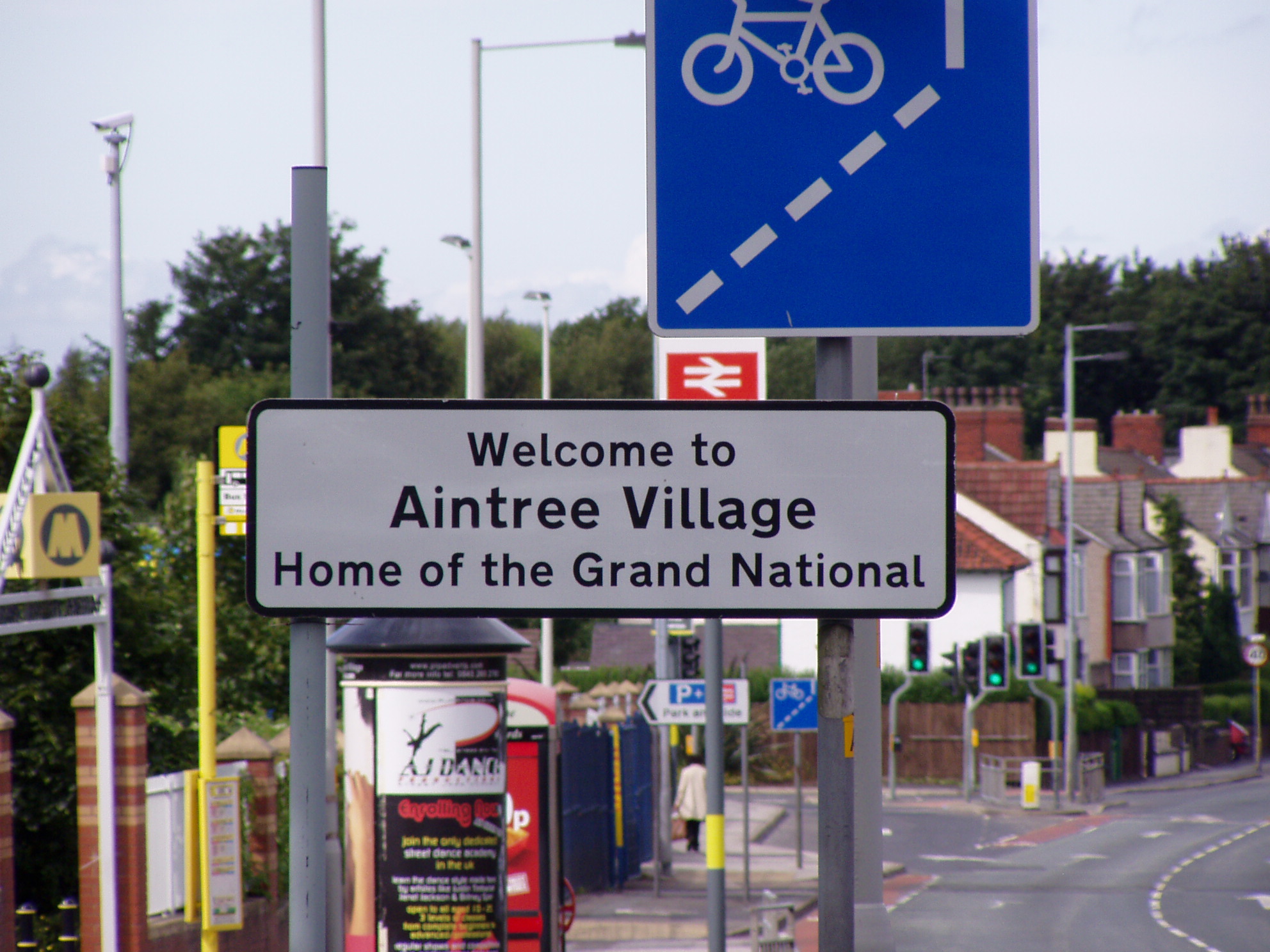
Aintree Village

Civil Parish in Lancashire Sefton

England

Aintree Village

Wear marks On the canal Bridge, grooves caused by the ropes when barges were being towed by horses.
Location Brewery Lane Melling
Wear marks Credit: Peter Hodge

Aintree Village is a civil parish located in the county of Lancashire, England. It is situated approximately 5 miles north of the city of Liverpool and falls within the boundaries of the Sefton borough. The village is predominantly residential, and its population is estimated to be around 7,000 people.

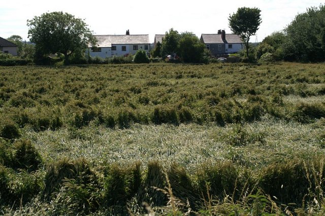
The history of Aintree Village can be traced back to the Domesday Book of 1086, where it was recorded as "Ainte". The village was primarily an agricultural community, with farming being the main occupation of its residents. However, the construction of the Aintree Racecourse in the late 18th century brought significant changes to the area.

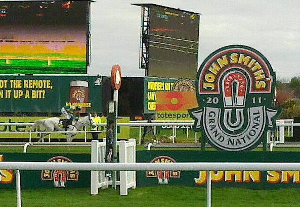
Aintree Racecourse is renowned for hosting the world-famous Grand National horse race, which attracts thousands of spectators each year. The racecourse also offers other equestrian events throughout the year, making it a significant tourist attraction.

In addition to the racecourse, Aintree Village is also home to Aintree University Hospital, which is one of the largest hospitals in the region. The hospital provides a wide range of medical services and employs a substantial number of local residents.

The village itself features a mix of modern and traditional architecture, with a variety of housing options available. There are several local amenities, including shops, schools, and community facilities, making Aintree Village a self-sufficient and desirable place to live.

Overall, Aintree Village is a vibrant and thriving community that combines its rich history with modern amenities and attractions, making it an attractive place to reside.

If you have any feedback on the listing, please let us know in the comments section below.

Aintree Village Images

Images are sourced within 2km of 53.480546/-2.941416 or Grid Reference SJ3798. Thanks to Geograph Open Source API. All images are credited.

Wear marks On the canal Bridge, grooves caused by the ropes when barges were being towed by horses.
Location Brewery Lane Melling
Wear marks
On the canal Bridge, grooves caused by the ropes when barges were being towed by horses. Location Brewery Lane Melling
Melling from the canal bridge Looking across the fields to Melling church from the bridge over the Leeds-Liverpool canal.
Melling from the canal bridge
Looking across the fields to Melling church from the bridge over the Leeds-Liverpool canal.
Church of St Thomas and the Holy Rood, Melling Church of St Thomas and the Holy Rood, Melling was founded before 1603.
Church of St Thomas and the Holy Rood, Melling
Church of St Thomas and the Holy Rood, Melling was founded before 1603.
This year's crops, Melling Battered crops in the summer that never was (2007).
This year's crops, Melling
Battered crops in the summer that never was (2007).
Leeds-Liverpool Canal, Melling A popular spot for fishing on the Leeds-Liverpool Canal near Brewery Lane, Melling.
Leeds-Liverpool Canal, Melling
A popular spot for fishing on the Leeds-Liverpool Canal near Brewery Lane, Melling.
Approaching the M57 at Switch Island
Switch Island View of M58 North bound access from A59.
Switch Island
View of M58 North bound access from A59.
Public footpath towards Sefton at Wood Hall Farm
Stone barn on Wood Hall Farm
Wood Hall
Wood Hall
A59 looking north
A59 looking north
Northern Perimeter Road
A59 at Switch Island The northbound A59 is now free-flowing across half of Switch Island, with a further three lanes to the right for access to the M57, one of which also functions as an escape lane for traffic to Liverpool or Ormskirk which has taken the wrong right-turn at the end of that motorway.  For more see: <a title="https://www.geograph.org.uk/photo/2884695" href="https://www.geograph.org.uk/photo/2884695">Link</a> and <span class="nowrap"><a title="http://www.cbrd.co.uk/badjunctions/57-58-59/" rel="nofollow ugc noopener" href="http://www.cbrd.co.uk/badjunctions/57-58-59/">Link</a><img style="margin-left:2px;" alt="External link" title="External link - shift click to open in new window" src="https://s1.geograph.org.uk/img/external.png" width="10" height="10"/></span> .
A59 at Switch Island
The northbound A59 is now free-flowing across half of Switch Island, with a further three lanes to the right for access to the M57, one of which also functions as an escape lane for traffic to Liverpool or Ormskirk which has taken the wrong right-turn at the end of that motorway. For more see: Link and LinkExternal link .
A59/M58 split, Switch Island The gantry is a relic of the pre-2006 layout when traffic leaving what was then a multi-lane roundabout was faced with an immediate choice of routes.  There is more space in which to make the decision nowadays.
A59/M58 split, Switch Island
The gantry is a relic of the pre-2006 layout when traffic leaving what was then a multi-lane roundabout was faced with an immediate choice of routes. There is more space in which to make the decision nowadays.
M58 motorway - A59 flyover, Switch Island
M58 motorway - curve onto the main alignment The history of Merseyside's motorways is littered with the ghosts of schemes never fulfilled.  The M58 was intended to continue to Liverpool's Seaforth Docks with this access from Switch Island being merely a slip road. Hence a tight S-bend at the start of the motorway.
M58 motorway - curve onto the main alignment
The history of Merseyside's motorways is littered with the ghosts of schemes never fulfilled. The M58 was intended to continue to Liverpool's Seaforth Docks with this access from Switch Island being merely a slip road. Hence a tight S-bend at the start of the motorway.
M58 motorway - Liverpool-Ormskirk railway bridge
Switch Island Junction
Show me another place!

Aintree Village is located at Grid Ref: SJ3798 (Lat: 53.480546, Lng: -2.941416)

Administrative County: Merseyside

District: Sefton

Police Authority: Merseyside

What 3 Words

///blaze.bags.jump. Near Melling, Merseyside

Nearby Locations

Aintree Village Aintree

Related Wikis

Aintree

Aintree is a village and civil parish in the Metropolitan Borough of Sefton, Merseyside, England. Historically in Lancashire, it lies between Walton and...

Aintree Racecourse

Aintree Racecourse is a racecourse in Aintree, Metropolitan Borough of Sefton, Merseyside, England, bordering the city of Liverpool. The racecourse is...

Grand National

The Grand National is a National Hunt horse race held annually at Aintree Racecourse, Aintree, Merseyside, England. First run in 1839, it is a handicap...

Aintree Motor Racing Circuit

Aintree Motor Racing Circuit is a 3.000 mi (4.828 km) motor racing circuit in the village of Aintree, Metropolitan Borough of Sefton, Merseyside, England...

Nearby Amenities

Located within 500m of 53.480546,-2.941416
Aintree
Place: suburb
Wikidata: Q406146
Wikipedia: en:Aintree
Lat/Long: 53.4803632/-2.9376261
Turning Circle
Source: Bing
Lat/Long: 53.4820665/-2.9453343
Traffic Calming: cushion
Lat/Long: 53.4809491/-2.9365117
Traffic Calming: cushion
Lat/Long: 53.4787816/-2.9392311
Traffic Calming: cushion
Lat/Long: 53.478496/-2.9399821
Traffic Calming: cushion
Lat/Long: 53.4777258/-2.9411019
Traffic Calming: cushion
Lat/Long: 53.4771887/-2.9417386
Crossing
Crossing: traffic_signals
Crossing Island: no
Lat/Long: 53.4769858/-2.9422267
Traffic Calming: cushion
Lat/Long: 53.4766301/-2.9429804
Bus Stop
AINTREE LANE/ORMSKIRK ROAD
Bus: yes
Naptan AtcoCode: 2800S53047A
Naptan Bearing: NW
Naptan CommonName: AINTREE LANE/ORMSKIRK ROAD
Naptan Indicator: AINTREE LANE/ORMSKIRK ROAD
Naptan Landmark: O/S 47 NR ELLESMERE DRIVE
Naptan NaptanCode: mergamad
Naptan Notes: No Notes
Naptan PlusbusZoneRef: LVRPLCH
Naptan ShortCommonName: Aintree Ln/Ormsk Rd
Naptan Street: AINTREE LANE
Naptan Verified: no
Public Transport: platform
Source: naptan_import
Lat/Long: 53.4833513/-2.946175
Bus Stop
AINTREE LANE/ORMSKIRK ROAD
Bus: yes
Naptan AtcoCode: 2800S53047B
Naptan Bearing: SE
Naptan CommonName: AINTREE LANE/ORMSKIRK ROAD
Naptan Indicator: AINTREE LANE/ORMSKIRK ROAD
Naptan Landmark: O/S 62
Naptan NaptanCode: mergamag
Naptan Notes: No Notes
Naptan PlusbusZoneRef: LVRPLCH
Naptan ShortCommonName: Aintree Ln/Ormsk Rd
Naptan Street: AINTREE LANE
Naptan Verified: no
Public Transport: platform
Source: naptan_import
Lat/Long: 53.4834658/-2.946479
Bus Stop
AINTREE LANE/ORMSKIRK ROAD
Bus: yes
Naptan AtcoCode: 2800S53048A
Naptan Bearing: NW
Naptan CommonName: AINTREE LANE/ORMSKIRK ROAD
Naptan Indicator: AINTREE LANE/ORMSKIRK ROAD
Naptan Landmark: OPP ATHOLL CRESCENT O/S ST GILES CHURCH
Naptan NaptanCode: mergamaj
Naptan Notes: No Notes
Naptan PlusbusZoneRef: LVRPLCH
Naptan ShortCommonName: Aintree Ln/Ormsk Rd
Naptan Street: AINTREE LANE
Naptan Verified: no
Public Transport: platform
Source: naptan_import
Lat/Long: 53.4810924/-2.9408203
Bus Stop
AINTREE LANE/ORMSKIRK ROAD
Bus: yes
Naptan AtcoCode: 2800S53048B
Naptan Bearing: SE
Naptan CommonName: AINTREE LANE/ORMSKIRK ROAD
Naptan Indicator: AINTREE LANE/ORMSKIRK ROAD
Naptan Landmark: NR CORNER ATHOLL CRESCENT O/S 97
Naptan NaptanCode: mergamam
Naptan Notes: No Notes
Naptan PlusbusZoneRef: LVRPLCH
Naptan ShortCommonName: Aintree Ln/Ormsk Rd
Naptan Street: AINTREE LANE
Naptan Verified: no
Public Transport: platform
Source: naptan_import
Lat/Long: 53.4809456/-2.9400486
Bus Stop
SCHOOL LANE/BULL BRIDGE LANE
Bus: yes
Naptan AtcoCode: 2800S53049A
Naptan Bearing: E
Naptan CommonName: SCHOOL LANE/BULL BRIDGE LANE
Naptan Indicator: SCHOOL LANE/BULL BRIDGE LANE
Naptan Landmark: OPP 27 O/S THE BLUE ANCHOR PH
Naptan NaptanCode: mergamap
Naptan Notes: No Notes
Naptan PlusbusZoneRef: LVRPLCH
Naptan ShortCommonName: The Blue Anchor
Naptan Street: SCHOOL LANE
Naptan Verified: no
Public Transport: platform
Source: naptan_import
Lat/Long: 53.4790461/-2.9346873
Bus Stop
SCHOOL LANE/BULL BRIDGE LANE
Bus: yes
Naptan AtcoCode: 2800S53049B
Naptan Bearing: E
Naptan CommonName: SCHOOL LANE/BULL BRIDGE LANE
Naptan Indicator: SCHOOL LANE/BULL BRIDGE LANE
Naptan Landmark: O/S 9
Naptan NaptanCode: mergamat
Naptan Notes: No Notes
Naptan PlusbusZoneRef: LVRPLCH
Naptan ShortCommonName: Sefton Dr
Naptan Street: SCHOOL LANE
Naptan Verified: no
Public Transport: platform
Source: naptan_import
Lat/Long: 53.4795649/-2.9361604
Bus Stop
ALTWAY/BULL BRIDGE LANE
Bus: yes
Naptan AtcoCode: 2800S53034A
Naptan Bearing: W
Naptan CommonName: ALTWAY/BULL BRIDGE LANE
Naptan Indicator: ALTWAY/BULL BRIDGE LANE
Naptan Landmark: NEXT TO 126 O/S AINTREE LIBRARY
Naptan NaptanCode: mergajpd
Naptan Notes: No Notes
Naptan PlusbusZoneRef: LVRPLCH
Naptan ShortCommonName: Halebury Av
Naptan Street: ALTWAY
Naptan Verified: no
Public Transport: platform
Source: naptan_import
Lat/Long: 53.4827474/-2.9361099
Bus Stop
ALTWAY/BULL BRIDGE LANE
Bus: yes
Naptan AtcoCode: 2800S53034B
Naptan Bearing: SE
Naptan CommonName: ALTWAY/BULL BRIDGE LANE
Naptan Indicator: ALTWAY/BULL BRIDGE LANE
Naptan Landmark: O/S POLICE STATION NR THE VALENTINE PH
Naptan NaptanCode: mergajpg
Naptan Notes: No Notes
Naptan PlusbusZoneRef: LVRPLCH
Naptan ShortCommonName: Halebury Av
Naptan Street: ALTWAY
Naptan Verified: no
Public Transport: platform
Source: naptan_import
Lat/Long: 53.4830619/-2.9372772
Bus Stop
ALTWAY/ORMSKIRK ROAD/BULL BRIDGE ROAD
Bus: yes
Naptan AtcoCode: 2800S53035A
Naptan Bearing: SE
Naptan CommonName: ALTWAY/ORMSKIRK ROAD/BULL BRIDGE ROAD
Naptan Indicator: ALTWAY/ORMSKIRK ROAD/BULL BRIDGE ROAD
Naptan Landmark: OPP 80/OPP CLIFTON DRIVE
Naptan NaptanCode: mergajpj
Naptan Notes: No Notes
Naptan PlusbusZoneRef: LVRPLCH
Naptan ShortCommonName: Altway/Ormskirk Rd
Naptan Street: ALTWAY
Naptan Verified: no
Public Transport: platform
Source: naptan_import
Lat/Long: 53.4838059/-2.9398255
Bus Stop
ALTWAY/ORMSKIRK ROAD/BULL BRIDGE ROAD
Bus: yes
Naptan AtcoCode: 2800S53035B
Naptan Bearing: SE
Naptan CommonName: ALTWAY/ORMSKIRK ROAD/BULL BRIDGE ROAD
Naptan Indicator: ALTWAY/ORMSKIRK ROAD/BULL BRIDGE ROAD
Naptan Landmark: O/S 70 ADJ CLIFTON DRIVE
Naptan NaptanCode: mergajpm
Naptan Notes: No Notes
Naptan PlusbusZoneRef: LVRPLCH
Naptan ShortCommonName: Altway/Ormskirk Rd
Naptan Street: ALTWAY
Naptan Verified: no
Public Transport: platform
Source: naptan_import
Lat/Long: 53.4840234/-2.9407496
Traffic Calming: cushion
Lat/Long: 53.4762451/-2.9436018
Traffic Calming: cushion
Lat/Long: 53.4814934/-2.9360661
Traffic Calming: cushion
Lat/Long: 53.4823186/-2.9354753
Leisure: playground
Lat/Long: 53.4821151/-2.9383903
The Big Event Group
Addr City: Liverpool
Addr Housenumber: Unit 6A
Addr Postcode: L9 5AY
Addr Street: Bechers Drive
Description: Event Organisation Company
Office: company
Opening Hours: Mo-Fr 09:00-17:00
Payment American Express: yes
Payment Credit Cards: yes
Payment Debit Cards: yes
Payment Maestro: yes
Payment Mastercard: yes
Payment Visa: yes
Payment Visa Debit: yes
Phone: +44 3452 601106
Smoking: outside
Website: https://www.bigeventgroup.com/
Wheelchair: yes
Lat/Long: 53.4803653/-2.9483737
Post Box
Collection Times: Mo-Fr 09:00; Sa 07:00
Description: GR type B post box L10 180 by Carron Company in Aintree Village at Melling Road bridge
Manufacturer: Carron Company
Operator: Royal Mail
Operator Wikidata: Q638098
Post Box Design: type_b
Post Box Type: pillar
Ref: L10 180
Royal Cypher: GR
Royal Cypher Wikidata: Q33102273
Wikimedia Commons: File:Post box in Aintree Village.jpg
Lat/Long: 53.4796143/-2.9369269
Post Box
Collection Times: Mo-Fr 16:45; Sa 12:00
Description: EIIR type K post box L10 865 by Carronade at Altway Post Office, Aintree.
Manufacturer: Carron Company
Operator: Royal Mail
Operator Wikidata: Q638098
Post Box Design: type_k
Post Box Type: pillar
Ref: L10 865
Royal Cypher: EIIR
Royal Cypher Wikidata: Q33102113
Wikimedia Commons: File:Post box at Altway Post Office, Aintree.jpg
Lat/Long: 53.4830123/-2.9361249
Traffic Calming: cushion
Lat/Long: 53.4781656/-2.9406209
Give Way
Direction: backward
Lat/Long: 53.4774498/-2.9413287
Traffic Signals
Crossing: no
Traffic Signals Direction: forward
Lat/Long: 53.4770294/-2.9421221
Traffic Signals
Crossing: no
Traffic Signals Direction: backward
Lat/Long: 53.4769423/-2.9423313
CTD Tiles
Addr City: Liverpool
Addr Housename: CTD Tiles
Addr Housenumber: Unit 4C, Aintree Business Park
Addr Postcode: L9 5AQ
Addr Street: Beechers Drive
Brand: CTD Tiles
Brand Wikidata: Q100295826
Operator: CTD Tiles
Phone: +44 151 525 9527
Shop: tiles
Website: https://www.ctdtiles.co.uk/t-tile-showroom-aintree.aspx
Lat/Long: 53.4806837/-2.9467518
The data included in this document is from www.openstreetmap.org. The data is made available under ODbL.

Have you been to Aintree Village?

Leave your review of Aintree Village below (or comments, questions and feedback).