Ynys-las

Settlement in Cardiganshire

Wales

Ynys-las

Looking along the sand bar The shifting sands bear little resemblance to the map. I believed I was in the square.
Looking along the sand bar Credit: Alison Rawson

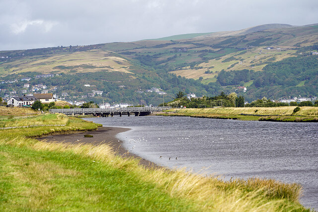
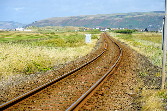
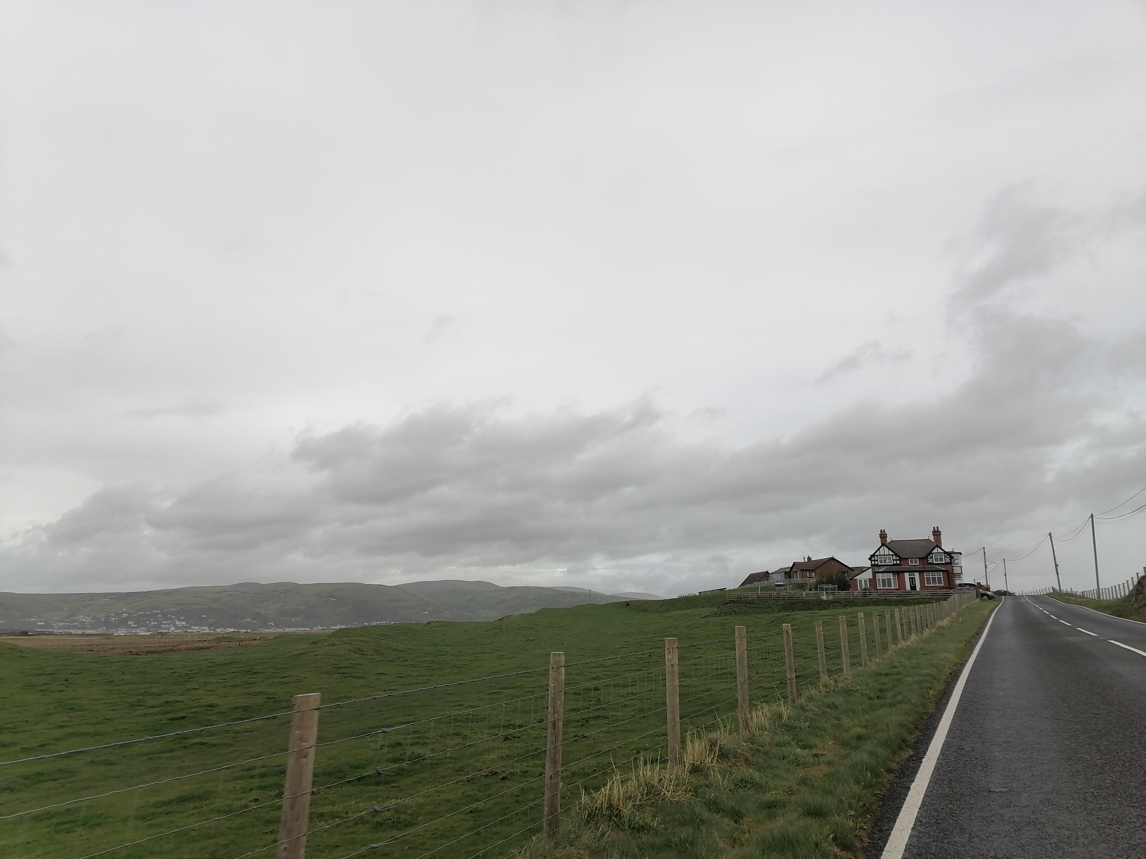
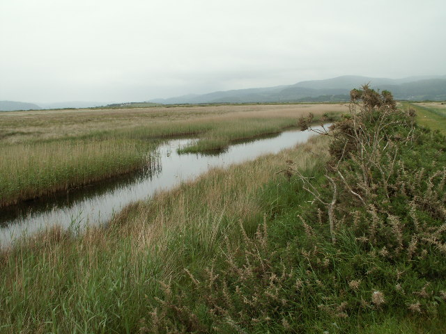
Ynys-las is a stunning coastal area located in Cardiganshire, Wales. Situated on the west coast of the country, it is nestled between the magnificent Cambrian Mountains and the sparkling waters of Cardigan Bay. The name "Ynys-las" translates to "blue island" in Welsh, which perfectly describes the area's breathtaking scenery.

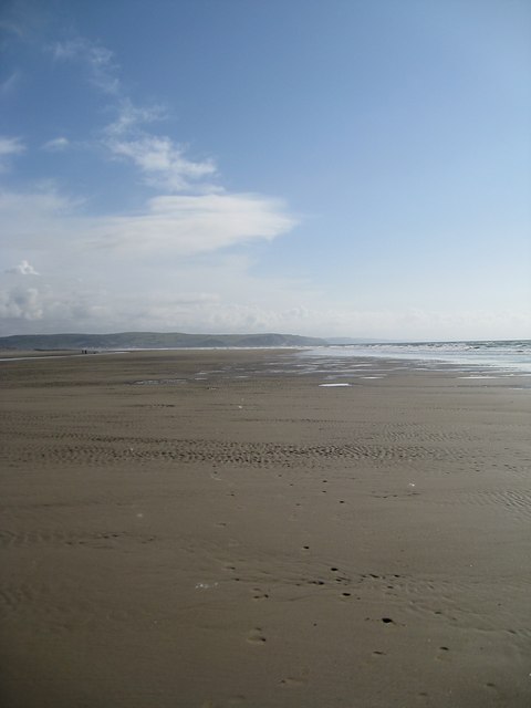
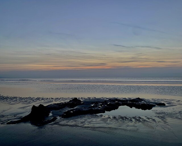
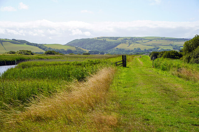
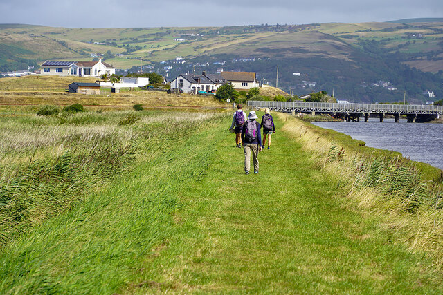
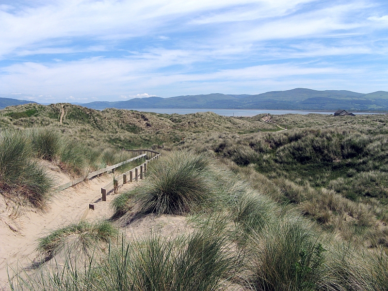
The main attraction of Ynys-las is its expansive sandy beach, which stretches for miles and is backed by impressive sand dunes. These dunes are not only a stunning sight but also play a vital role in the local ecosystem, as they are designated as a National Nature Reserve. The reserve is home to a diverse range of flora and fauna, including rare and protected species. Birdwatchers flock to Ynys-las to catch a glimpse of the resident and migratory bird populations, which include the famous red kite and oystercatchers.

Aside from its natural beauty, Ynys-las offers a range of recreational activities for visitors. The beach is perfect for swimming, paddling, and building sandcastles, while the dunes provide an ideal setting for picnics and leisurely walks. The area is also a popular spot for water sports enthusiasts, with opportunities for surfing, kiteboarding, and windsurfing.

Ynys-las is easily accessible, with ample parking and facilities, including a visitor center that provides information about the reserve and its wildlife. Additionally, there are nearby amenities such as cafes, restaurants, and accommodations for those looking to stay in the area.

In summary, Ynys-las in Cardiganshire is a picturesque coastal destination, offering a stunning beach, sand dunes, and a rich variety of wildlife. It is a must-visit location for nature lovers, beachgoers, and those seeking a tranquil escape in the heart of Wales.

If you have any feedback on the listing, please let us know in the comments section below.

Ynys-las Images

Images are sourced within 2km of 52.5123/-4.052399 or Grid Reference SN6092. Thanks to Geograph Open Source API. All images are credited.

Looking along the sand bar The shifting sands bear little resemblance to the map. I believed I was in the square.
Looking along the sand bar
The shifting sands bear little resemblance to the map. I believed I was in the square.
The first (or last) house in Borth Art Deco property on Princess Street.
The first (or last) house in Borth
Art Deco property on Princess Street.
Horse riders on Traeth Maelgwyn Aberdovey is about a mile away across the Dovey estuary.
Horse riders on Traeth Maelgwyn
Aberdovey is about a mile away across the Dovey estuary.
A damp day on the Dyfi estuary
Machlud yr haul ar ddiwrnod byrraf Sundown on the shortest day, with a fragment of the ancient petrified forest on the beach between Borth and Ynyslas.
Machlud yr haul ar ddiwrnod byrraf
Sundown on the shortest day, with a fragment of the ancient petrified forest on the beach between Borth and Ynyslas.
'Stop me and buy one' On the beach at Ynyslas, with Aberdyfi just in view across the Dyfi estuary.
'Stop me and buy one'
On the beach at Ynyslas, with Aberdyfi just in view across the Dyfi estuary.
Eroding muddy sediments A view of the edge of the rising tide. Laminated, muddy sediments have been eroded by rough weather from the north, making a small cliff adjacent to the luxuriant forest of samphire.
Eroding muddy sediments
A view of the edge of the rising tide. Laminated, muddy sediments have been eroded by rough weather from the north, making a small cliff adjacent to the luxuriant forest of samphire.
Dune crest Looking from the crest of dunes by Twyni Bach towards the lower Dyfi estuary. The parched condition of distant hill pasture is the result of extraordinary drought.
Dune crest
Looking from the crest of dunes by Twyni Bach towards the lower Dyfi estuary. The parched condition of distant hill pasture is the result of extraordinary drought.
A train for Aberystwyth approaching the Afon Leri bridge
The Afon Leri rail bridge at Ynyslas
The boat yard at Ynyslas Beside Afon Leri. About a mile from the confluence of Afon Leri and Afon Dyfi.
The boat yard at Ynyslas
Beside Afon Leri. About a mile from the confluence of Afon Leri and Afon Dyfi.
On the Ceredigion Coastal Path Beside the Afon Leri cut.
On the Ceredigion Coastal Path
Beside the Afon Leri cut.
Military relic From the 2nd World War, when a weapons-testing range was established at Ynyslas. Testing was moved to Aberporth in 1946 which continues in use. Now the hut is, somewhat ignominiously, used to store hay. The story of the range can be found here: <span class="nowrap"><a title="https://www.cambrian-news.co.uk/news/the-secret-sands-one-of-world-war-iis-most-secret-research-facilities-504561" rel="nofollow ugc noopener" href="https://www.cambrian-news.co.uk/news/the-secret-sands-one-of-world-war-iis-most-secret-research-facilities-504561">Link</a><img style="margin-left:2px;" alt="External link" title="External link - shift click to open in new window" src="https://s1.geograph.org.uk/img/external.png" width="10" height="10"/></span>
Military relic
From the 2nd World War, when a weapons-testing range was established at Ynyslas. Testing was moved to Aberporth in 1946 which continues in use. Now the hut is, somewhat ignominiously, used to store hay. The story of the range can be found here: LinkExternal link
Walking the Ceredigion Coastal path With the combined rail/path bridge across Afon Leri ahead.
Walking the Ceredigion Coastal path
With the combined rail/path bridge across Afon Leri ahead.
Heavy plant crossing A machine being delivered to the Network Rail depot at Ynyslas.
Heavy plant crossing
A machine being delivered to the Network Rail depot at Ynyslas.
Viewed across the reeds A train heading for Borth and thence Aberystwyth. On the left, some of the many holiday caravans which are to be found between Borth and Ynyslas.
Viewed across the reeds
A train heading for Borth and thence Aberystwyth. On the left, some of the many holiday caravans which are to be found between Borth and Ynyslas.
The Cambrian Coast Line north of Borth Viewed from Borth Golf crossing.
The Cambrian Coast Line north of Borth
Viewed from Borth Golf crossing.
'Stop when lights show' Warning sign for Ynylas level crossing.
'Stop when lights show'
Warning sign for Ynylas level crossing.
Show me another place!

Ynys-las is located at Grid Ref: SN6092 (Lat: 52.5123, Lng: -4.052399)

Unitary Authority: Ceredigion

Police Authority: Dyfed Powys

Also known as: Ynyslas

What 3 Words

///workflow.funded.seaweed. Near Borth, Ceredigion

Related Wikis

Ynys Tachwedd

Ynys Tachwedd is a hamlet in the community of Borth, Ceredigion, Wales, which is 80.5 miles (129.6 km) from Cardiff and 180.5 miles (290.5 km) from London...

Afon Leri

Afon Leri (Welsh pronunciation: [ˈlɛri]; also known as the River Leri) is a river in Ceredigion, Wales. It rises at Llyn Craig-y-Pistyll and is joined...

Cors Fochno

Cors Fochno (Welsh pronunciation: [kɔrs ˈvɔχnɔ]) is a raised peat bog near the village of Borth, in the county of Ceredigion, Wales. Lying on the south...

Ynyslas Sand Dunes

Ynyslas Sand Dunes (Welsh: Twyni Tywod Ynyslas) are sand dunes located in Ceredigion, Wales. They border Cardigan Bay and the Dyfi Estuary between Ynyslas...

Nearby Amenities

Located within 500m of 52.5123,-4.052399
Railway: level_crossing
Lat/Long: 52.5096222/-4.0503259
Source: PGS
Lat/Long: 52.5155385/-4.0570152
Source: PGS
Lat/Long: 52.5145646/-4.0567666
Source: PGS
Lat/Long: 52.5137619/-4.0565406
Source: PGS
Lat/Long: 52.5136173/-4.0566721
Source: PGS
Lat/Long: 52.5125492/-4.0564614
Source: PGS
Lat/Long: 52.510102/-4.055818
Source: PGS
Lat/Long: 52.5091127/-4.0555089
Post Box
Operator: Royal Mail
Ref: SY24 77
Lat/Long: 52.5124505/-4.0524182
Ynyslas
Place: hamlet
Wikidata: Q8054078
Lat/Long: 52.5132994/-4.0516766
Bus Stop
Ynyslas Turn
Bench: yes
Bin: no
Check Date Shelter: 2023-08-22
Lit: no
Public Transport: platform
Shelter: yes
Tactile Paving: no
Lat/Long: 52.5122321/-4.0529229
Direction: 165
Generator Method: photovoltaic
Generator Output Electricity: yes
Generator Solar Modules: 8
Generator Source: solar
Generator Type: solar_photovoltaic_panel
Location: roof
Power: generator
Lat/Long: 52.5127674/-4.0502677
Direction: 165
Generator Method: photovoltaic
Generator Output Electricity: yes
Generator Solar Modules: 14
Generator Source: solar
Generator Type: solar_photovoltaic_panel
Location: roof
Power: generator
Lat/Long: 52.5127441/-4.0504146
Direction: SSE
Generator Method: photovoltaic
Generator Output Electricity: yes
Generator Solar Modules: 16
Generator Source: solar
Generator Type: solar_photovoltaic_panel
Location: roof
Power: generator
Lat/Long: 52.5126088/-4.0509564
Direction: 175
Generator Method: photovoltaic
Generator Output Electricity: yes
Generator Solar Modules: 12
Generator Source: solar
Generator Type: solar_photovoltaic_panel
Location: roof
Power: generator
Lat/Long: 52.5128935/-4.0524463
Direction: 145
Generator Method: photovoltaic
Generator Output Electricity: yes
Generator Solar Modules: 8
Generator Source: solar
Generator Type: solar_photovoltaic_panel
Location: roof
Power: generator
Lat/Long: 52.5127212/-4.0477538
Direction: 145
Generator Method: photovoltaic
Generator Output Electricity: yes
Generator Solar Modules: 10
Generator Source: solar
Generator Type: solar_photovoltaic_panel
Location: roof
Power: generator
Lat/Long: 52.5127653/-4.0476492
The data included in this document is from www.openstreetmap.org. The data is made available under ODbL.

Have you been to Ynys-las?

Leave your review of Ynys-las below (or comments, questions and feedback).