Wade Hall

Settlement in Lancashire South Ribble

England

Wade Hall

Runshaw Lane
Runshaw Lane Credit: David Dixon

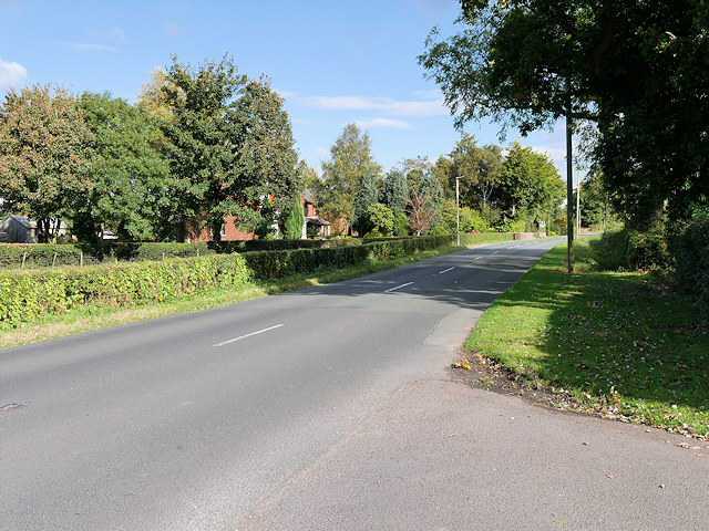
Wade Hall is a small rural village located in the county of Lancashire, England. Situated in the picturesque countryside, the village is encompassed by lush green fields and rolling hills, creating a serene and idyllic atmosphere. With a population of around 500 residents, Wade Hall offers a close-knit community that values the tranquility and beauty of its surroundings.

The village is dotted with traditional stone houses and cottages, showcasing the architectural charm of the region. Its history can be traced back to the medieval era, with remnants of ancient structures still visible, including the historic St. Mary's Church, which dates back to the 12th century. The church stands as a testament to the village's rich heritage and provides a place for religious worship and community gatherings.

Wade Hall boasts several amenities for its residents, including a local pub, village hall, and a primary school, catering to the needs of both young and old. The village is also well-connected to nearby towns and cities, with good transportation links and access to major roads.

Nature enthusiasts will find plenty to explore in and around Wade Hall, with several walking trails and nature reserves nearby. The village is surrounded by stunning countryside, offering breathtaking views and opportunities for outdoor activities such as hiking, cycling, and horseback riding.

Overall, Wade Hall is a peaceful and charming village that offers a high quality of life, with its close community, rich history, and beautiful natural surroundings.

If you have any feedback on the listing, please let us know in the comments section below.

Wade Hall Images

Images are sourced within 2km of 53.688249/-2.710977 or Grid Reference SD5321. Thanks to Geograph Open Source API. All images are credited.

Runshaw Lane
Runshaw Lane
Old Milestone by the B5253, Leyland Lane, Leyland Parish Stone post (plate lost) by the B5253, in parish of LEYLAND (SOUTH RIBBLE District), Leyland Lane, South of Brookfold Farm, on East side of road. Preston iron plate, erected by the Penwortham & Wrightington turnpike trust in the 19th century. 

Inscription once read:-
(TO)
(PRESTON)
(7)
(MILES) 
Carved benchmark on front under plate.  

Milestone Society National ID: LA_PSWG07.
Old Milestone by the B5253, Leyland Lane, Leyland Parish
Stone post (plate lost) by the B5253, in parish of LEYLAND (SOUTH RIBBLE District), Leyland Lane, South of Brookfold Farm, on East side of road. Preston iron plate, erected by the Penwortham & Wrightington turnpike trust in the 19th century. Inscription once read:- (TO) (PRESTON) (7) (MILES) Carved benchmark on front under plate. Milestone Society National ID: LA_PSWG07.
Old Boundary Marker by the B5253, Hollins Brook Bridge, Leyland Lane Parish Boundary Marker by the B5253, in parish of Eccleston (Chorley District), Leyland Lane, Hollins Brook Bridge, East side of road.

Carved bench mark and pivot on top.

Surveyed

Milestone Society National ID: LA_PSWG07pb
Old Boundary Marker by the B5253, Hollins Brook Bridge, Leyland Lane
Parish Boundary Marker by the B5253, in parish of Eccleston (Chorley District), Leyland Lane, Hollins Brook Bridge, East side of road. Carved bench mark and pivot on top. Surveyed Milestone Society National ID: LA_PSWG07pb
1896 Thornycroft steam van, The British Commercial Vehicle Museum, King Street, Leyland Increase in the speed limit to 14 mph in 1896 promoted the increase in steam driven vehicles. This front wheel drive rear steer van was built by John Isaac Thornycroft of Chiswick and first took to the road on 2 Jan. 1897. In Newport, Mr William Duncan tried to climb aboard his newly delivered van whilst it was moving and slipped. Run over by his own vehicle this was the first motor vehicle accident in Wales resulting in the amputation of one of William's feet. One of the earliest steam road vehicles it was powered by a coke fired steamboat engine by Simpson Strickland and Co. Dartmouth.
1896 Thornycroft steam van, The British Commercial Vehicle Museum, King Street, Leyland
Increase in the speed limit to 14 mph in 1896 promoted the increase in steam driven vehicles. This front wheel drive rear steer van was built by John Isaac Thornycroft of Chiswick and first took to the road on 2 Jan. 1897. In Newport, Mr William Duncan tried to climb aboard his newly delivered van whilst it was moving and slipped. Run over by his own vehicle this was the first motor vehicle accident in Wales resulting in the amputation of one of William's feet. One of the earliest steam road vehicles it was powered by a coke fired steamboat engine by Simpson Strickland and Co. Dartmouth.
Leyland Railway Station
British Commercial Vehicle Museum, Leyland The car park and entrance to this most excellent museum. It has had a face-lift since Roger Cornfoot was there in 2015 - <a href="https://www.geograph.org.uk/photo/4529223">SD5422 : The British Commercial Vehicle Museum, Leyland</a>
British Commercial Vehicle Museum, Leyland
The car park and entrance to this most excellent museum. It has had a face-lift since Roger Cornfoot was there in 2015 - SD5422 : The British Commercial Vehicle Museum, Leyland
19th Century horse-drawn bus Originally from the Edinburgh and District Tramways Company Limited, now at the Leyland Commercial Vehicles Museum. For a rear view see <a href="https://www.geograph.org.uk/photo/7006065">SD5422 : 19th Century horse-drawn bus</a>
19th Century horse-drawn bus
Originally from the Edinburgh and District Tramways Company Limited, now at the Leyland Commercial Vehicles Museum. For a rear view see SD5422 : 19th Century horse-drawn bus
19th Century horse-drawn bus Originally from the Edinburgh and District Tramways Company Limited, now at the Leyland Commercial Vehicles Museum. For a side view see <a href="https://www.geograph.org.uk/photo/7006059">SD5422 : 19th Century horse-drawn bus</a>

FARE 
BUS & CAR 3d 
BUS 1d

For the younger amongst us 3d = 1.25p, and 1d = 0.416p
19th Century horse-drawn bus
Originally from the Edinburgh and District Tramways Company Limited, now at the Leyland Commercial Vehicles Museum. For a side view see SD5422 : 19th Century horse-drawn bus FARE BUS & CAR 3d BUS 1d For the younger amongst us 3d = 1.25p, and 1d = 0.416p
The Edinburgh & District Tramways Company Limited The company's logo on the horse tram at the British Commercial Vehicle Museum <a href="https://www.geograph.org.uk/photo/7006059">SD5422 : 19th Century horse-drawn bus</a>. It operated from 1893 to 1919 <span class="nowrap"><a title="https://en.wikipedia.org/wiki/Edinburgh_and_District_Tramways" rel="nofollow ugc noopener" href="https://en.wikipedia.org/wiki/Edinburgh_and_District_Tramways">Link</a><img style="margin-left:2px;" alt="External link" title="External link - shift click to open in new window" src="https://s1.geograph.org.uk/img/external.png" width="10" height="10"/></span>.
The Edinburgh & District Tramways Company Limited
The company's logo on the horse tram at the British Commercial Vehicle Museum SD5422 : 19th Century horse-drawn bus. It operated from 1893 to 1919 LinkExternal link.
Television Detector Van A 1979 Dodge Space Van that served as a TV licence detector van, in the British Commercial Vehicle Museum. The vehicle on the left is a 1927 Model T Ford van - see <a href="https://www.geograph.org.uk/photo/7006155">SD5422 : Ford 'Model T'</a> for details.
Television Detector Van
A 1979 Dodge Space Van that served as a TV licence detector van, in the British Commercial Vehicle Museum. The vehicle on the left is a 1927 Model T Ford van - see SD5422 : Ford 'Model T' for details.
Ford 'Model T' Details of the Ford van at the British Commercial Vehicle Museum <a href="https://www.geograph.org.uk/photo/7006143">SD5422 : Television Detector Van</a>.
Ford 'Model T'
Details of the Ford van at the British Commercial Vehicle Museum SD5422 : Television Detector Van.
Post Office Radio Service Van A 1949 Leyland Morris 'Y' Type van in the British Commercial Vehicle Museum. For details see <a href="https://www.geograph.org.uk/photo/7006164">SD5422 : Leyland Morris 'Y' Type van - details</a>. This one has a trailer attached.
Post Office Radio Service Van
A 1949 Leyland Morris 'Y' Type van in the British Commercial Vehicle Museum. For details see SD5422 : Leyland Morris 'Y' Type van - details. This one has a trailer attached.
Leyland Morris 'Y' Type van - details Details of the van at <a href="https://www.geograph.org.uk/photo/7006161">SD5422 : Post Office Radio Service Van</a>.
Leyland Morris 'Y' Type van - details
Steam Lawnmower, 1896 Built by James Sumner in the early 1890s this was the beginning of a thriving business, Lancashire Steam Motors Co., that became Leyland Motors. This is a replica, from an original belonging to Repton College, with an original engine re-built by Leyland Apprentices. I wonder how many kg of coal and litres of water it would use per 100 sq. m., and if it would be ULEZ/COP26 compliant?
Steam Lawnmower, 1896
Built by James Sumner in the early 1890s this was the beginning of a thriving business, Lancashire Steam Motors Co., that became Leyland Motors. This is a replica, from an original belonging to Repton College, with an original engine re-built by Leyland Apprentices. I wonder how many kg of coal and litres of water it would use per 100 sq. m., and if it would be ULEZ/COP26 compliant?
A showman's engine, Fowler no. 10318 Built in March 1905 for W.H. Marshall & Sons of Bradford. The engine is named Sunny Boy 2 and carries the registration WR 6790. Now in the British Commercial Vehicle Museum. For another view see <a href="https://www.geograph.org.uk/photo/7006209">SD5422 : A showman's engine, Fowler no. 10318,</a>.
A showman's engine, Fowler no. 10318
Built in March 1905 for W.H. Marshall & Sons of Bradford. The engine is named Sunny Boy 2 and carries the registration WR 6790. Now in the British Commercial Vehicle Museum. For another view see SD5422 : A showman's engine, Fowler no. 10318,.
A showman's engine, Fowler no. 10318, 'SUNNY BOY No.2' at the British Commercial Vehicle Museum. For another view see <a href="https://www.geograph.org.uk/photo/7006202">SD5422 : A showman's engine, Fowler no. 10318</a>, and a closer view of the wheel <a href="https://www.geograph.org.uk/photo/7006211">SD5422 : A showman's engine, Fowler no. 10318,</a>.
A showman's engine, Fowler no. 10318,
'SUNNY BOY No.2' at the British Commercial Vehicle Museum. For another view see SD5422 : A showman's engine, Fowler no. 10318, and a closer view of the wheel SD5422 : A showman's engine, Fowler no. 10318,.
A showman's engine, Fowler no. 10318, A close-up of the main driving wheel of <a href="https://www.geograph.org.uk/photo/7006202">SD5422 : A showman's engine, Fowler no. 10318</a>.
A showman's engine, Fowler no. 10318,
A close-up of the main driving wheel of SD5422 : A showman's engine, Fowler no. 10318.
Popemobile at Leyland One of two special vehicles built for Pope John Paul II's visit to the UK in 1982. Two were made, Leyland T45, based on the Constructor 6 chassis. See <a href="https://www.geograph.org.uk/photo/7006222">SD5422 : Leyland T45 Popemobile</a> for details.
Popemobile at Leyland
One of two special vehicles built for Pope John Paul II's visit to the UK in 1982. Two were made, Leyland T45, based on the Constructor 6 chassis. See SD5422 : Leyland T45 Popemobile for details.
Show me another place!

Wade Hall is located at Grid Ref: SD5321 (Lat: 53.688249, Lng: -2.710977)

Administrative County: Lancashire

District: South Ribble

Police Authority: Lancashire

What 3 Words

///packet.rent.closet. Near Leyland, Lancashire

Related Wikis

St Mary's Catholic High School, Leyland

St Mary's Catholic High School is a coeducational secondary school located in Leyland in the English county of Lancashire.It is a voluntary aided school...

Academy@Worden

Worden Academy is a coeducational secondary school with academy status, located in Leyland, in the South Ribble district of Lancashire, England. It opened...

Leyland, Lancashire

Leyland ( LAY-lənd) is a town in South Ribble, Lancashire, England, 6 miles (10 km) south of Preston. The population was 35,578 at the 2011 Census.The...

Occleshaw House

Occleshaw House, also known by its address as 2 Worden Lane, is a Grade II listed building in Leyland, Lancashire. The building has been described as the...

Worden Park

Worden Park is a large area of parkland situated on the outskirts of Leyland, a town in the borough of South Ribble, Lancashire, England. It is less than...

St Andrew's Church, Leyland

St Andrew's Church is an Anglican church in Leyland, Lancashire, England. It is an active Anglican parish church in the Diocese of Blackburn and the archdeaconry...

Wellfield Academy

Wellfield Academy (formerly Wellfield High School) is a coeducational secondary school located in Leyland in the English county of Lancashire.Wellfield...

County Ground (Leyland)

The County Ground is a football stadium in Leyland, Lancashire, England, which is owned and operated by Lancashire County Football Association (Lancashire...

Nearby Amenities

Located within 500m of 53.688249,-2.710977
Mini Roundabout
Direction: clockwise
Lat/Long: 53.6889106/-2.7163932
Crossing
Crossing: zebra
Lat/Long: 53.6891341/-2.7170087
Mini Roundabout
Direction: clockwise
Lat/Long: 53.6882932/-2.71098
Turning Circle
Lat/Long: 53.6842166/-2.713459
Turning Circle
Lat/Long: 53.6849516/-2.7090908
Turning Circle
Lat/Long: 53.689183/-2.7053276
Post Box
Brand: Royal Mail
Brand Wikidata: Q638098
Mapillary: 114403414679955
Operator: Royal Mail
Operator Wikidata: Q638098
Post Box Type: pillar
Ref: PR25 450
Survey Date: 2022-07-29
Lat/Long: 53.6886919/-2.7126432
Bus Stop
Queensway
Bus: yes
Naptan AtcoCode: 25001102
Naptan Bearing: W
Naptan CommonName: Queensway
Naptan Indicator: by
Naptan NaptanCode: lanadtpa
Public Transport: platform
Shelter: yes
Lat/Long: 53.6884615/-2.7121884
Bus Stop
Queensway
Bus: yes
Naptan AtcoCode: 2500DCL3301
Naptan Bearing: E
Naptan CommonName: Queensway
Naptan Indicator: opp
Naptan NaptanCode: landjapt
Public Transport: platform
Shelter: yes
Lat/Long: 53.6886486/-2.7124641
Bus Stop
Spar Leyland Lane
Bench: no
Bus: yes
Covered: no
Naptan AtcoCode: 2500DCL3289
Naptan Bearing: S
Naptan CommonName: Seven Stars
Naptan Indicator: by
Naptan NaptanCode: landjama
Public Transport: platform
Shelter: no
Lat/Long: 53.6893076/-2.7165033
Bus Stop
Seven Stars
Bus: yes
Naptan AtcoCode: 2500DCL3291
Naptan Bearing: NW
Naptan CommonName: St Annes School
Naptan Indicator: o/s
Naptan NaptanCode: landjamg
Public Transport: platform
Lat/Long: 53.689159/-2.7173033
Pub
Old Original Seven Stars
Addr City: Leyland
Addr Country: GB
Addr Housenumber: 2
Addr Postcode: PR25 1TL
Addr Street: Slater Lane
Phone: +44 1772 435712
Lat/Long: 53.6892379/-2.7169749
Pub
The Crofters
Addr City: Leyland
Addr Street: Leyland Lane
Lat/Long: 53.6879251/-2.7160051
Atm
Source: GPS, local knowledge
Lat/Long: 53.6894095/-2.716503
Speed Camera
Maxspeed: 30 mph
Lat/Long: 53.6888143/-2.7132692
Bus Stop
Seven Stars
Bench: yes
Bus: yes
Covered: yes
Naptan AtcoCode: 25001105
Naptan Bearing: N
Naptan CommonName: Seven Stars
Naptan Indicator: opp
Naptan NaptanCode: lanadtwp
Public Transport: platform
Lat/Long: 53.6886521/-2.7164013
Traffic Calming: hump
Lat/Long: 53.6919535/-2.7109395
Traffic Calming: bump
Lat/Long: 53.6907073/-2.7112502
Traffic Calming: hump
Lat/Long: 53.6913313/-2.7109831
Traffic Calming: hump
Lat/Long: 53.6901581/-2.7113732
Barrier: entrance
Lat/Long: 53.6909962/-2.7073221
Doctors
Worden Medical Center
Addr City: Leyland
Addr Postcode: PR25 1HR
Addr Street: West Paddock
Healthcare: doctor
Opening Hours: Mo-Fr 08:00-18:30
Phone: +44 1772 423555
Website: https://www.wordenmc.net/
Lat/Long: 53.6903885/-2.7083191
Barrier: kissing_gate
Lat/Long: 53.6912994/-2.7078521
Barrier: kissing_gate
Lat/Long: 53.6916418/-2.7080547
Bus: yes
Public Transport: stop_position
Lat/Long: 53.6900929/-2.7051435
Post Box
Operator: Royal Mail
Ref: PR25 48
Lat/Long: 53.6894717/-2.7166891
Barrier: bollard
Bicycle: yes
Foot: yes
Lat/Long: 53.6905476/-2.7156137
Bus Stop
Seven Stars
Bench: yes
Bus: yes
Naptan AtcoCode: 2500DCL3292
Naptan Bearing: E
Naptan CommonName: St Annes RCS
Naptan Indicator: opp
Naptan NaptanCode: landjamj
Public Transport: platform
Shelter: no
Tactile Paving: no
Lat/Long: 53.6893995/-2.7176708
Morrisons Daily
Addr City: Leyland
Addr Country: GB
Addr Housenumber: 69
Addr Postcode: PR25 1BX
Addr Street: Royal Avenue
Brand: Morrisons Daily
Brand Wikidata: Q99752411
Fhrs Id: 467735
Old Name: Wade Hall Convenience Store
Operator: McColl's
Operator Wikidata: Q16997477
Shop: convenience
Website: https://my.morrisons.com/storefinder/61273/morrisons-daily-leyland-royal-avenue
Lat/Long: 53.6846589/-2.7115395
Childcare
Wade Hall Child Centre
Addr City: Leyland
Addr Street: Royal Avenue
Lat/Long: 53.6843391/-2.7116134
Pub
Seven Stars
Addr City: Leyland
Addr Housenumber: 355
Addr Postcode: PR25 1TA
Addr Street: Leyland Lane
Fhrs Id: 1067855
Operator: Stonegate
Operator Wikidata: Q7619176
Website: https://www.craftunionpubs.com/seven-stars-leyland
Lat/Long: 53.6887731/-2.7160669
Bottle & Basket
Addr City: Leyland
Addr Street: Leyland Lane
Shop: alcohol
Lat/Long: 53.6882452/-2.7165606
A & S Cakes
Addr City: Leyland
Addr Street: Leyland Lane
Craft: confectionery
Lat/Long: 53.6883164/-2.7165606
Fast Food
Simply Scrumptious
Addr City: Leyland
Addr Street: Leyland Lane
Drive Through: no
Lat/Long: 53.6883784/-2.7165606
Seven Stars Carpets & Vinyls
Addr City: Leyland
Addr Street: Leyland Lane
Shop: carpet
Lat/Long: 53.6884404/-2.7165606
Ladbrokes
Addr City: Leyland
Addr Street: Leyland Lane
Brand: Ladbrokes
Brand Wikidata: Q1799875
Brand Wikipedia: en:Ladbrokes Coral
Shop: bookmaker
Lat/Long: 53.6885225/-2.7165668
Waste Basket
Lat/Long: 53.6884404/-2.7163696
Fast Food
Seven Stars
Addr City: Leyland
Addr Housenumber: 360
Addr Postcode: PR25 1TB
Addr Street: Leyland Lane
Cuisine: indian
Drive Through: no
Fhrs Id: 159154
Takeaway: only
Lat/Long: 53.6885955/-2.716576
Fast Food
Leyland Fish & Chips
Addr City: Leyland
Addr Housenumber: 358
Addr Postcode: PR25 1TB
Addr Street: Leyland Lane
Cuisine: fish_and_chips
Drive Through: no
Fhrs Id: 940873
Takeaway: only
Lat/Long: 53.688663/-2.7166007
Waste Basket
Waste: trash;dog_excrement
Lat/Long: 53.6887287/-2.716422
Waste Basket
Waste: trash;dog_excrement
Lat/Long: 53.688736/-2.7162186
Bonce
Addr City: Leyland
Addr Street: Leyland Lane
Phone: +44 1772 421 929
Shop: hairdresser
Lat/Long: 53.6887305/-2.7166161
Cosmopolitan
Addr City: Leyland
Addr Street: Leyland Lane
Shop: beauty
Lat/Long: 53.6888017/-2.7166438
Waste Basket
Waste: trash;dog_excrement
Lat/Long: 53.6888692/-2.7165421
Pharmacy
Rowlands Pharmacy
Addr City: Leyland
Addr Street: Leyland Lane
Brand: Rowlands Pharmacy
Brand Wikidata: Q62663235
Healthcare: pharmacy
Lat/Long: 53.688871/-2.716653
Clarkson
Addr City: Leyland
Addr Housenumber: 346
Addr Postcode: PR25 1TB
Addr Street: Leyland Lane
Fhrs Id: 28238
Shop: butcher
Lat/Long: 53.6889257/-2.7166869
Post Box
Ref: PR25 390
Lat/Long: 53.6838237/-2.7115422
Post Box
Brand: Royal Mail
Brand Wikidata: Q638098
Mapillary: 768142764338701
Operator: Royal Mail
Operator Wikidata: Q638098
Post Box Mounting: pier
Post Box Type: lamp
Ref: PR25 207
Survey Date: 2022-07-27
Lat/Long: 53.6851759/-2.7164249
Sunseekers
Addr City: Leyland
Addr Housenumber: 289
Addr Postcode: PR25 1UN
Addr Street: Leyland Lane
Beauty: tanning
Opening Hours: Mo-Fr 09:00-21:30, Sa 09:00-19:00, Su 11:00-18:00
Shop: beauty
Lat/Long: 53.690913/-2.716798
Crossing
Crossing: zebra
Lat/Long: 53.6889209/-2.7158473
Fast Food
Tatjana's Sandwich Shop
Addr City: Leyland
Addr Street: Leyland Lane
Cuisine: sandwich
Drive Through: no
Takeaway: only
Lat/Long: 53.6890647/-2.7163816
J & C Bargain Stores
Addr City: Leyland
Addr Street: Leyland Lane
Shop: variety_store
Lat/Long: 53.6892155/-2.7164701
Classeys
Addr City: Leyland
Addr Housenumber: 347
Addr Postcode: PR25 1UP
Addr Street: Leyland Lane
Phone: +44 1772 458857
Shop: hairdresser
Lat/Long: 53.6891536/-2.7164379
Spar
Addr City: Leyland
Addr Housenumber: 343
Addr Postcode: PR25 1UP
Addr Street: Leyland Lane
Brand: Spar
Brand Wikidata: Q610492
Brand Wikipedia: en:Spar (retailer)
Fhrs Id: 28236
Shop: supermarket
Website: https://www.spar.co.uk/store-locator/hal22046-spar-leyland/
Lat/Long: 53.6893569/-2.7164272
Waste Basket
Waste: trash;dog_excrement
Lat/Long: 53.6893172/-2.7165291
Old Mill Garage
Addr City: Leyland
Phone: +44 1772 455 446
Shop: car_repair
Lat/Long: 53.6906953/-2.717099
Cafe
Addr City: Leyland
Addr Street: Leyland Lane
Lat/Long: 53.6906503/-2.7169028
Pharmacy
Worden Pharmacy
Addr City: Leyland
Addr Street: West Paddock
Healthcare: pharmacy
Lat/Long: 53.6903272/-2.7079268
Seven Stars
Place: neighbourhood
Source: local knowledge;OS Opendata
Lat/Long: 53.6888358/-2.7162149
Wade Hall
Place: neighbourhood
Source: local knowledge;OS Opendata
Lat/Long: 53.6849332/-2.711928
Post Office
Leyland Lane Post Office
Addr City: Leyland
Addr Housenumber: 343
Addr Postcode: PR25 1UP
Addr Street: Leyland Lane
Brand: Post Office
Brand Wikidata: Q1783168
Note: in Spar
Opening Hours: Mo-Sa 07:00-22:00; Su 08:00-22:00
Ref Pol Id: 136456
Source: pol_branch_list_2018-02
Website: https://www.postoffice.co.uk/branch-finder/4514270/leyland-lane
Lat/Long: 53.6893257/-2.7164212
Bus Stop
Civic Centre
Bus: yes
Naptan AtcoCode: 25001088
Naptan Bearing: E
Naptan CommonName: Civic Centre
Naptan Indicator: by
Naptan NaptanCode: lanadptg
Public Transport: platform
Lat/Long: 53.6901215/-2.7050688
Direction: SW
Generator Method: photovoltaic
Generator Output Electricity: yes
Generator Solar Modules: 14
Generator Source: solar
Generator Type: solar_photovoltaic_panel
Location: roof
Power: generator
Lat/Long: 53.6889447/-2.7121793
Direction: SW
Generator Method: photovoltaic
Generator Output Electricity: yes
Generator Solar Modules: 14
Generator Source: solar
Generator Type: solar_photovoltaic_panel
Location: roof
Power: generator
Lat/Long: 53.6890197/-2.7124925
Crossing
Crossing: uncontrolled
Crossing Ref: zebra
Lat/Long: 53.6877556/-2.7054545
Bus Stop
Royal Avenue
Bus: yes
Naptan AtcoCode: 250015531
Naptan Bearing: W
Naptan CommonName: Royal Avenue
Naptan Indicator: by
Naptan NaptanCode: lanapmwd
Public Transport: platform
Lat/Long: 53.6877132/-2.7049679
Bus Stop
Forestway
Bus: yes
Naptan AtcoCode: 2500DCL3302
Naptan Bearing: E
Naptan CommonName: Forestway
Naptan Indicator: by
Naptan NaptanCode: landjapw
Public Transport: platform
Lat/Long: 53.6878247/-2.704349
Bus Stop
St Marys School
Bus: yes
Naptan AtcoCode: 2500LAA00484
Naptan Bearing: NE
Naptan CommonName: St Marys School
Naptan Indicator: by
Naptan NaptanCode: langwgtp
Public Transport: platform
Lat/Long: 53.685631/-2.7090214
Bus Stop
Queensway Shops
Bus: yes
Naptan AtcoCode: 2500LA00039
Naptan Bearing: N
Naptan CommonName: Queensway Shops
Naptan Indicator: opp
Naptan NaptanCode: langmwjm
Public Transport: platform
Lat/Long: 53.6844609/-2.7123177
Bus Stop
Queensway Shops
Bus: yes
Naptan AtcoCode: 2500LA00038
Naptan Bearing: S
Naptan CommonName: Queensway Shops
Naptan Indicator: by
Naptan NaptanCode: langmwjg
Public Transport: platform
Lat/Long: 53.684381/-2.7121498
Bus Stop
The Crofters
Bus: yes
Naptan AtcoCode: 2500DCL3290
Naptan Bearing: S
Naptan CommonName: The Crofters
Naptan Indicator: by
Naptan NaptanCode: landjamd
Public Transport: platform
Lat/Long: 53.688204/-2.7161817
Bus Stop
South Ribble Borough Council Offices
Bus: yes
Naptan AtcoCode: 2500DCL3305
Naptan Bearing: W
Naptan CommonName: South Ribble Borough Council Offices
Naptan Indicator: opp
Naptan NaptanCode: landjatg
Public Transport: platform
Lat/Long: 53.6900221/-2.705158
Direction: SE
Generator Method: photovoltaic
Generator Output Electricity: yes
Generator Solar Modules: 16
Generator Source: solar
Generator Type: solar_photovoltaic_panel
Location: roof
Power: generator
Lat/Long: 53.684183/-2.7097379
Direction: SE
Generator Method: photovoltaic
Generator Output Electricity: yes
Generator Solar Modules: 16
Generator Source: solar
Generator Type: solar_photovoltaic_panel
Location: roof
Power: generator
Lat/Long: 53.6841552/-2.7098773
Direction: SE
Generator Method: photovoltaic
Generator Output Electricity: yes
Generator Solar Modules: 16
Generator Source: solar
Generator Type: solar_photovoltaic_panel
Location: roof
Power: generator
Lat/Long: 53.6843339/-2.7103722
Direction: SE
Generator Method: photovoltaic
Generator Output Electricity: yes
Generator Solar Modules: 16
Generator Source: solar
Generator Type: solar_photovoltaic_panel
Location: roof
Power: generator
Lat/Long: 53.6843856/-2.7101456
Direction: SE
Generator Method: photovoltaic
Generator Output Electricity: yes
Generator Solar Modules: 16
Generator Source: solar
Generator Type: solar_photovoltaic_panel
Location: roof
Power: generator
Lat/Long: 53.6844094/-2.710045
The data included in this document is from www.openstreetmap.org. The data is made available under ODbL.

Have you been to Wade Hall?

Leave your review of Wade Hall below (or comments, questions and feedback).