Bothenhampton

Settlement in Dorset

England

Bothenhampton

Cliff edge
Cliff edge Credit: don cload

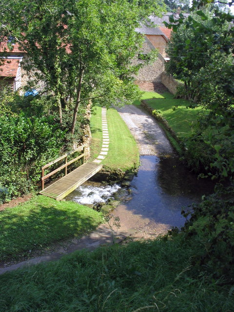
Bothenhampton is a small village situated in the county of Dorset, England. Located just one mile northeast of Bridport, it forms part of the Bridport urban area. The village is nestled in a picturesque rural setting, surrounded by rolling hills and stunning countryside.

Bothenhampton has a rich history dating back to the Saxon era, with evidence of human settlement in the area for over a thousand years. The village is mentioned in the Domesday Book of 1086, highlighting its significance during the medieval period. Today, it retains much of its historic charm and character, with several listed buildings and traditional thatched cottages lining its streets.

The village is home to a close-knit community, and residents benefit from a range of amenities and services. These include a village hall, a primary school, and a church. The nearby town of Bridport offers additional facilities and entertainment options, including shops, restaurants, and a weekly market.

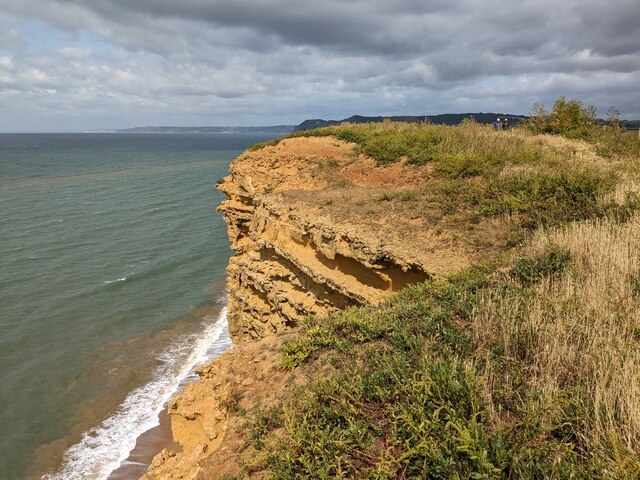
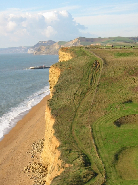
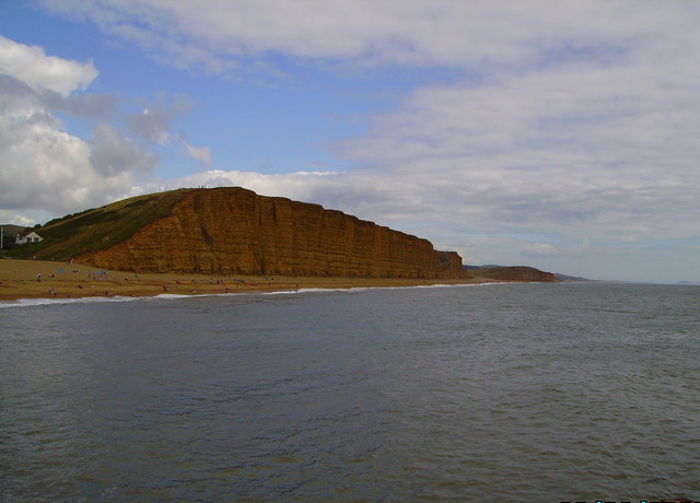
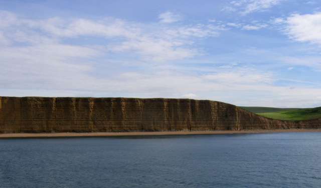
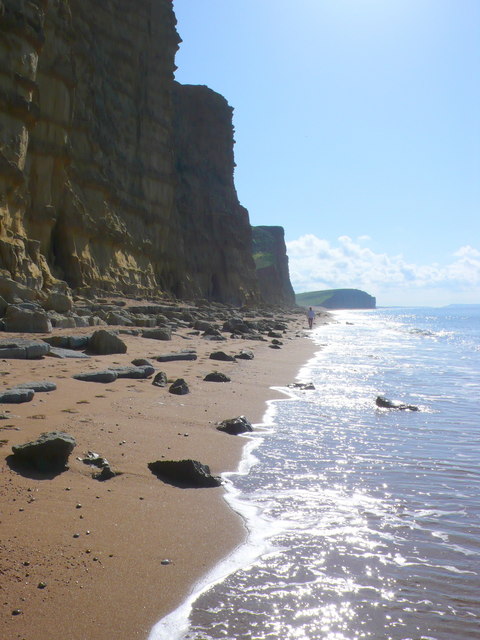
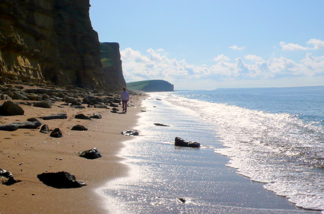
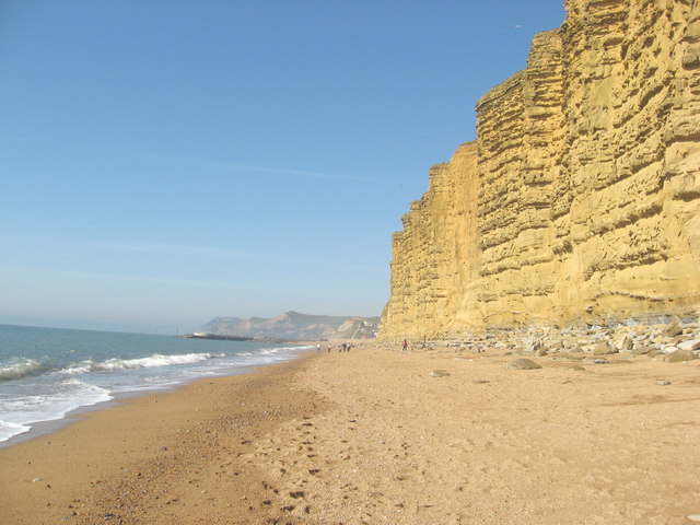
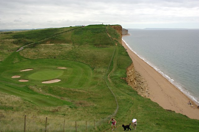
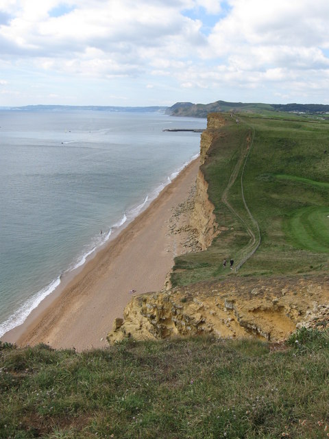
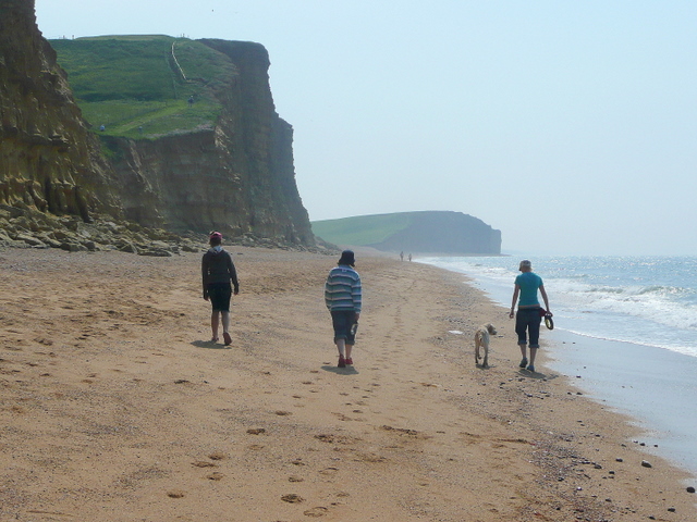
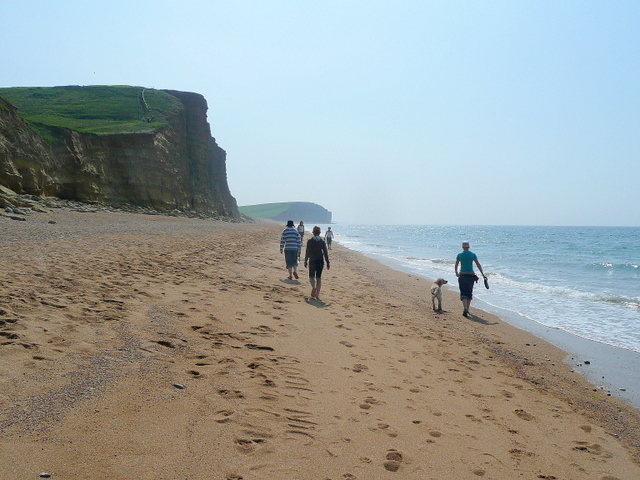
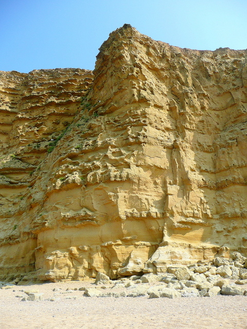
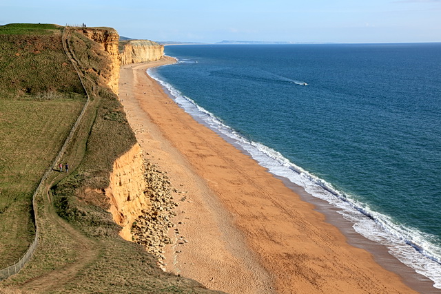
Nature lovers are drawn to Bothenhampton due to its proximity to the stunning Jurassic Coast, a UNESCO World Heritage Site. This coastline, just a short distance away, boasts breathtaking cliffs, beautiful beaches, and a wealth of fossil discoveries.

Bothenhampton enjoys excellent transportation links, with the A35 road passing nearby, connecting the village to other parts of Dorset and beyond. The closest railway station is located in nearby Maiden Newton, providing further accessibility to the area.

In summary, Bothenhampton is a tranquil and historic village in Dorset, offering a peaceful rural lifestyle, beautiful scenery, and convenient access to both local amenities and the stunning Jurassic Coast.

If you have any feedback on the listing, please let us know in the comments section below.

Bothenhampton Images

Images are sourced within 2km of 50.723113/-2.7482754 or Grid Reference SY4791. Thanks to Geograph Open Source API. All images are credited.

Cliff edge
Cliff edge
Coast west of Burton Freshwater Some steps have since been built on the very eroded section of the coast path.
Coast west of Burton Freshwater
Some steps have since been built on the very eroded section of the coast path.
East cliff at West Bay Dorset Picture taken from the new pier
East cliff at West Bay Dorset
Picture taken from the new pier
Cliffs between West Bay and Burton Freshwater The cliffs along this coastline are part of the World Heritage Jurassic Coast. They date back to Jurassic times and are very popular with fossil hunters. 
To see some 360°Panoramas of Dorset please visit this <span class="nowrap"><a title="www.360panoramas.co.uk" rel="nofollow ugc noopener" href="http://www.360panoramas.co.uk">Link</a><img style="margin-left:2px;" alt="External link" title="External link - shift click to open in new window" src="https://s1.geograph.org.uk/img/external.png" width="10" height="10"/></span>
Cliffs between West Bay and Burton Freshwater
The cliffs along this coastline are part of the World Heritage Jurassic Coast. They date back to Jurassic times and are very popular with fossil hunters. To see some 360°Panoramas of Dorset please visit this LinkExternal link
East Cliffs, West Bay, Dorset Looking SE along the small bit of coast in this square. A real danger of falling rocks here and a much lesser danger of falling golf balls from the golf course on top of the cliffs
East Cliffs, West Bay, Dorset
Looking SE along the small bit of coast in this square. A real danger of falling rocks here and a much lesser danger of falling golf balls from the golf course on top of the cliffs
East Cliffs, West Bay, Dorset Looking NW. The two people in the middle distance are on the northern side of the E-W grid line. The cliffs are made of Bridport Sands which erodes in distinct bands because some layers are harder than others.
East Cliffs, West Bay, Dorset
Looking NW. The two people in the middle distance are on the northern side of the E-W grid line. The cliffs are made of Bridport Sands which erodes in distinct bands because some layers are harder than others.
East Cliffs, West Bay, Dorset Looking SE with Portland in the distance. The beach is littered with rocks that fell from the cliff
East Cliffs, West Bay, Dorset
Looking SE with Portland in the distance. The beach is littered with rocks that fell from the cliff
The lovely golden East Cliff at West Bay These spectacular cliffs are at West Bay, South of Bridport, Dorset
The lovely golden East Cliff at West Bay
These spectacular cliffs are at West Bay, South of Bridport, Dorset
The Top of East Cliff The coast path runs just a few feet from the cliff edge.
The Top of East Cliff
The coast path runs just a few feet from the cliff edge.
A Dip in the Clifftop The flat clifftop walk between West Bay and Burton Freshwater is interrupted by this little coombe. One of the greens of the adjacent golf course lurks in the bottom of the valley.
A Dip in the Clifftop
The flat clifftop walk between West Bay and Burton Freshwater is interrupted by this little coombe. One of the greens of the adjacent golf course lurks in the bottom of the valley.
View across the dip in the East Cliff at West Bay, Dorset. West Bay's harbour wall can be seen jutting out into the sea.
View across the dip in the East Cliff at West Bay, Dorset.
West Bay's harbour wall can be seen jutting out into the sea.
Burton Freshwater Caravan park As well as the static caravans such as these ones there are a large number of pitches for touring caravans. View north close to the northern edge of the grid square.
Burton Freshwater Caravan park
As well as the static caravans such as these ones there are a large number of pitches for touring caravans. View north close to the northern edge of the grid square.
Freshwater Beach, Dorset Looking westwards towards East Cliff and West Bay.
Freshwater Beach, Dorset
Looking westwards towards East Cliff and West Bay.
Retrieved! A water-loving dog brings a rubber ring back to the beach. And then does it again. And again. And again.....
Retrieved!
A water-loving dog brings a rubber ring back to the beach. And then does it again. And again. And again.....
Morning beach walk These folks and their dog are probably heading for the holiday park at Burton Bradstock.
Every so often the man on the right throws the rubber ring into the sea for the Retriever to do his thing.
See <a href="https://www.geograph.org.uk/photo/1903326">SY4689 : Retrieved!</a>.
Morning beach walk
These folks and their dog are probably heading for the holiday park at Burton Bradstock. Every so often the man on the right throws the rubber ring into the sea for the Retriever to do his thing. See SY4689 : Retrieved!.
Strolling along the beach The folks and dog in <a href="https://www.geograph.org.uk/photo/1903332">SY4689 : Morning beach walk</a>, a little further along towards Burton Bradstock.
Strolling along the beach
The folks and dog in SY4689 : Morning beach walk, a little further along towards Burton Bradstock.
Section of East Cliff The easily-eroded sandstone is a golden colour in summer morning light.
Section of East Cliff
The easily-eroded sandstone is a golden colour in summer morning light.
Coast Path towards Burton Freshwater from East Cliff Coast path, cliffs and beach viewed from East Cliff. In the far distance the outline of the Isle of Portland can just be seen.
Coast Path towards Burton Freshwater from East Cliff
Coast path, cliffs and beach viewed from East Cliff. In the far distance the outline of the Isle of Portland can just be seen.
Show me another place!

Bothenhampton is located at Grid Ref: SY4791 (Lat: 50.723113, Lng: -2.7482754)

Unitary Authority: Dorset

Police Authority: Dorset

What 3 Words

///styled.situation.limiting. Near Bridport, Dorset

Related Wikis

Bothenhampton

Bothenhampton is a village and civil parish in southwest Dorset, England, just outside the town of Bridport. It is separated from the town only by the...

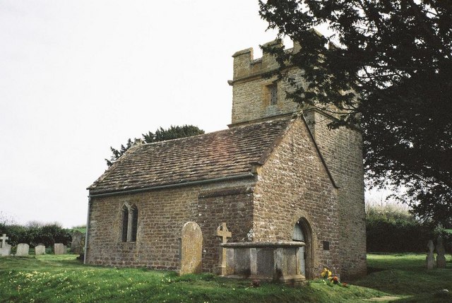
Holy Trinity Old Church, Bothenhampton

Holy Trinity Old Church in Bothenhampton, Dorset, England was built in the 13th or 14th century. It is recorded in the National Heritage List for England...

Holy Trinity Church, Bothenhampton

Holy Trinity Church is a Church of England parish church at Bothenhampton, near Bridport in Dorset, England. It was designed and built by the English arts...

River Asker

The River Asker is a small river in Dorset, England. It rises on the chalk slopes of Eggardon Hill, approximately five miles (8 km) east of Bridport. It...

Bridport F.C.

Bridport Football Club is a football club based in Bridport, Dorset, England. Affiliated to the Dorset County Football Association, they are currently...

Bridport East Street railway station

Bridport East Street was a railway station on the Bridport Railway in the west of the English county of Dorset. Opened on 11 March 1884, before the extension...

St. Mary's Church, Bridport

St Mary's Church is an Anglican parish church in Bridport, Dorset, England. It is a Grade I listed building. Part of the Bridport Team Ministry, it is...

Bridport Museum

Bridport Museum is a museum in Bridport, Dorset, England. It is housed within an early 16th century building known as the Castle, located on South Street...

Nearby Amenities

Located within 500m of 50.723113,-2.7482754
Bothenhampton
Is In: Dorset, England, UK
Place: village
Lat/Long: 50.7244036/-2.7506775
Public Bookcase
Booth: K6
Covered: booth
Disused Amenity: telephone
Man Made: telephone_box
Public Bookcase Type: phone_box
Lat/Long: 50.7240416/-2.7506301
Crossing
Crossing: unmarked
Crossing Island: no
Crossing Markings: no
Kerb: lowered
Tactile Paving: no
Lat/Long: 50.726473/-2.7502394
Addr Housenumber: 2
Addr Street: South Lawns
Lat/Long: 50.7252508/-2.7532915
Addr Housenumber: 8
Addr Street: South Lawns
Lat/Long: 50.7248508/-2.7535758
Addr Housenumber: 14
Addr Postcode: DT6 4DS
Addr Street: South Lawns
Lat/Long: 50.7250377/-2.7529519
Addr Housenumber: 1
Addr Street: South Lawns
Lat/Long: 50.7256348/-2.7531636
Addr Housenumber: 22
Addr Street: Maple Gardens
Lat/Long: 50.7256624/-2.7540455
Addr Housenumber: 18
Addr Street: Maple Gardens
Lat/Long: 50.725814/-2.7537531
Addr Housenumber: 15
Addr Postcode: DT6 4DR
Addr Street: Maple Gardens
Lat/Long: 50.7255043/-2.7535265
Post Box
Post Box Type: lamp
Postal Code: DT6
Ref: DT6 58
Ref GB Uprn: 10015411789
Lat/Long: 50.7221602/-2.7531457
Bus Stop
Bus: yes
Public Transport: platform
Lat/Long: 50.7212218/-2.7530211
Barrier: kissing_gate
Foot: yes
Lat/Long: 50.7209773/-2.7515013
Bothen (Hyde) Hill
Natural: peak
Lat/Long: 50.7263374/-2.7449251
Generator Method: photovoltaic
Generator Output Electricity: yes
Generator Source: solar
Generator Type: solar_photovoltaic_panel
Location: roof
Power: generator
Lat/Long: 50.7236183/-2.7511525
Generator Method: photovoltaic
Generator Output Electricity: yes
Generator Source: solar
Generator Type: solar_photovoltaic_panel
Location: roof
Power: generator
Lat/Long: 50.7240801/-2.7514637
Generator Method: photovoltaic
Generator Output Electricity: yes
Generator Source: solar
Generator Type: solar_photovoltaic_panel
Location: roof
Power: generator
Lat/Long: 50.7250293/-2.7492079
Generator Method: photovoltaic
Generator Output Electricity: yes
Generator Source: solar
Generator Type: solar_photovoltaic_panel
Location: roof
Power: generator
Lat/Long: 50.7254572/-2.7500126
Generator Method: photovoltaic
Generator Output Electricity: yes
Generator Source: solar
Generator Type: solar_photovoltaic_panel
Location: roof
Power: generator
Lat/Long: 50.7263214/-2.7502003
Generator Method: photovoltaic
Generator Output Electricity: yes
Generator Source: solar
Generator Type: solar_photovoltaic_panel
Location: roof
Power: generator
Lat/Long: 50.7259054/-2.7490872
Generator Method: photovoltaic
Generator Output Electricity: yes
Generator Source: solar
Generator Type: solar_photovoltaic_panel
Location: roof
Power: generator
Lat/Long: 50.7259411/-2.7492991
Generator Method: photovoltaic
Generator Output Electricity: yes
Generator Source: solar
Generator Type: solar_photovoltaic_panel
Location: roof
Power: generator
Lat/Long: 50.726065/-2.7495673
Generator Method: photovoltaic
Generator Output Electricity: yes
Generator Source: solar
Generator Type: solar_photovoltaic_panel
Location: roof
Power: generator
Lat/Long: 50.7271704/-2.7510908
Generator Method: photovoltaic
Generator Output Electricity: yes
Generator Source: solar
Generator Type: solar_photovoltaic_panel
Location: roof
Power: generator
Lat/Long: 50.7271245/-2.7510345
Generator Method: photovoltaic
Generator Output Electricity: yes
Generator Source: solar
Generator Type: solar_photovoltaic_panel
Location: roof
Power: generator
Lat/Long: 50.7270481/-2.750769
Generator Method: photovoltaic
Generator Output Electricity: yes
Generator Source: solar
Generator Type: solar_photovoltaic_panel
Location: roof
Power: generator
Lat/Long: 50.726953/-2.7509299
Generator Method: photovoltaic
Generator Output Electricity: yes
Generator Source: solar
Generator Type: solar_photovoltaic_panel
Location: roof
Power: generator
Lat/Long: 50.7259173/-2.753537
Generator Method: photovoltaic
Generator Output Electricity: yes
Generator Source: solar
Generator Type: solar_photovoltaic_panel
Location: roof
Power: generator
Lat/Long: 50.7240818/-2.7551061
Generator Method: photovoltaic
Generator Output Electricity: yes
Generator Source: solar
Generator Type: solar_photovoltaic_panel
Location: roof
Power: generator
Lat/Long: 50.7221019/-2.7532876
Generator Method: photovoltaic
Generator Output Electricity: yes
Generator Source: solar
Generator Type: solar_photovoltaic_panel
Location: roof
Power: generator
Lat/Long: 50.721905/-2.7549103
Generator Method: photovoltaic
Generator Output Electricity: yes
Generator Source: solar
Generator Type: solar_photovoltaic_panel
Location: roof
Power: generator
Lat/Long: 50.7196669/-2.7525312
Generator Method: photovoltaic
Generator Output Electricity: yes
Generator Source: solar
Generator Type: solar_photovoltaic_panel
Location: roof
Power: generator
Lat/Long: 50.7214108/-2.7517507
Generator Method: photovoltaic
Generator Output Electricity: yes
Generator Source: solar
Generator Type: solar_photovoltaic_panel
Location: roof
Power: generator
Lat/Long: 50.7233958/-2.7543578
Generator Method: photovoltaic
Generator Output Electricity: yes
Generator Source: solar
Generator Type: solar_photovoltaic_panel
Location: roof
Power: generator
Lat/Long: 50.7227421/-2.7533358
Generator Method: photovoltaic
Generator Output Electricity: yes
Generator Source: solar
Generator Type: solar_photovoltaic_panel
Location: roof
Power: generator
Lat/Long: 50.7214057/-2.7528557
Generator Method: photovoltaic
Generator Output Electricity: yes
Generator Source: solar
Generator Type: solar_photovoltaic_panel
Location: roof
Power: generator
Lat/Long: 50.721708/-2.7528182
Generator Method: photovoltaic
Generator Output Electricity: yes
Generator Source: solar
Generator Type: solar_photovoltaic_panel
Location: roof
Power: generator
Lat/Long: 50.7211086/-2.7532956
Generator Method: photovoltaic
Generator Output Electricity: yes
Generator Source: solar
Generator Type: solar_photovoltaic_panel
Location: roof
Power: generator
Lat/Long: 50.7215348/-2.753647
Generator Method: photovoltaic
Generator Output Electricity: yes
Generator Source: solar
Generator Type: solar_photovoltaic_panel
Location: roof
Power: generator
Lat/Long: 50.7215365/-2.7537087
Generator Method: photovoltaic
Generator Output Electricity: yes
Generator Source: solar
Generator Type: solar_photovoltaic_panel
Location: roof
Power: generator
Lat/Long: 50.7218574/-2.7537462
Generator Method: photovoltaic
Generator Output Electricity: yes
Generator Source: solar
Generator Type: solar_photovoltaic_panel
Location: roof
Power: generator
Lat/Long: 50.7218625/-2.7538106
Generator Method: photovoltaic
Generator Output Electricity: yes
Generator Source: solar
Generator Type: solar_photovoltaic_panel
Location: roof
Power: generator
Lat/Long: 50.7231827/-2.7530113
The data included in this document is from www.openstreetmap.org. The data is made available under ODbL.

Have you been to Bothenhampton?

Leave your review of Bothenhampton below (or comments, questions and feedback).