Millbay Docks

Settlement in Devon

England

Millbay Docks

Racing gigs at Mount Batten Three racing gigs sit on the hard surface close to Mount Batten North Slipway. They belong to Cattewater Plymouth Gig Rowing Club. The Citadel can be seen in the background.
Racing gigs at Mount Batten Credit: Stephen McKay

Millbay Docks is a historic waterfront area located in Plymouth, Devon, in the southwest of England. Situated on the eastern side of the city's waterfront, it has played a significant role in the maritime and industrial history of the region.

Originally built in the 19th century, Millbay Docks served as a thriving commercial port and a hub for the transportation of goods and passengers. It was strategically positioned to accommodate the growing trade demands of the city and to support the nearby Royal Navy dockyards. The docks were initially used for the export of local products like china clay, granite, and limestone, as well as for the import of various goods from around the world.

Over the years, Millbay Docks underwent several transformations and expansions to meet the changing needs of the maritime industry. However, with the decline in traditional shipping and the closure of the Royal Navy dockyard, the area experienced a period of decline in the late 20th century.

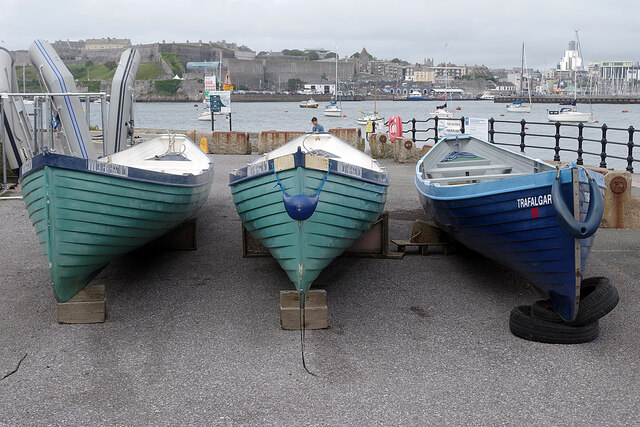
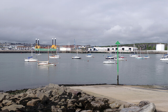
In recent years, Millbay Docks has been revitalized through a major redevelopment project. The area has been transformed into a vibrant mixed-use development that includes modern residential buildings, offices, restaurants, bars, and leisure facilities. The regeneration has also seen the creation of a marina, providing berthing for both leisure and commercial vessels.

Today, Millbay Docks stands as a testament to Plymouth's maritime heritage while embracing its future as a modern and lively waterfront destination. It continues to attract visitors, residents, and businesses, offering a unique blend of history, culture, and contemporary amenities.

If you have any feedback on the listing, please let us know in the comments section below.

Millbay Docks Images

Images are sourced within 2km of 50.364595/-4.154744 or Grid Reference SX4653. Thanks to Geograph Open Source API. All images are credited.

Racing gigs at Mount Batten Three racing gigs sit on the hard surface close to Mount Batten North Slipway. They belong to Cattewater Plymouth Gig Rowing Club. The Citadel can be seen in the background.
Racing gigs at Mount Batten
Three racing gigs sit on the hard surface close to Mount Batten North Slipway. They belong to Cattewater Plymouth Gig Rowing Club. The Citadel can be seen in the background.
Racing gigs at Mount Batten A line up of three racing gigs belonging to Cattewater Plymouth Gig Rowing Club. See <a href="https://www.geograph.org.uk/photo/6940069">SX4853 : Racing gigs at Mount Batten</a> for a different view.
Racing gigs at Mount Batten
A line up of three racing gigs belonging to Cattewater Plymouth Gig Rowing Club. See SX4853 : Racing gigs at Mount Batten for a different view.
Mount Batten Ferry Terminal The ferry arrives at the jetty from the Barbican, ready to take another load of passengers back.
Mount Batten Ferry Terminal
The ferry arrives at the jetty from the Barbican, ready to take another load of passengers back.
Mount Batten Ferry Terminal Passengers alight at Mount Batten having arrived from the Barbican.
Mount Batten Ferry Terminal
Passengers alight at Mount Batten having arrived from the Barbican.
Mount Batten North Slipway Referred to on maps as the western slipway, on the Plymouth City Council website as the north west slipway and on signs as the north slipway, this is the smaller of two public slipways at Mount Batten for launching boats into Cattewater.
Mount Batten North Slipway
Referred to on maps as the western slipway, on the Plymouth City Council website as the north west slipway and on signs as the north slipway, this is the smaller of two public slipways at Mount Batten for launching boats into Cattewater.
Old Boundary Marker on Ford Park Road, Plymouth Municipal Boundary Marker in Plymouth set in a stone wall on the east side of Ford Park Road opposite the cemetery entrance. Inscribed D.C.B. / St LEVAN / MAYOR / 1891. The Right Hon John Lord St Levan was mayor of Devonport County Borough in 1891.

Milestone Society National ID: DV_DCBBS01pb
Old Boundary Marker on Ford Park Road, Plymouth
Municipal Boundary Marker in Plymouth set in a stone wall on the east side of Ford Park Road opposite the cemetery entrance. Inscribed D.C.B. / St LEVAN / MAYOR / 1891. The Right Hon John Lord St Levan was mayor of Devonport County Borough in 1891. Milestone Society National ID: DV_DCBBS01pb
Old Boundary Marker on North Quay, Plymouth Municipal Boundary Marker between buttresses and against a stone wall on the north side of North Quay, behind the buildings on the south side of Millbay Road. Erected by East Stonehouse Local Board of Health.

Milestone Society National ID: DV_ESBS01pb
Old Boundary Marker on North Quay, Plymouth
Municipal Boundary Marker between buttresses and against a stone wall on the north side of North Quay, behind the buildings on the south side of Millbay Road. Erected by East Stonehouse Local Board of Health. Milestone Society National ID: DV_ESBS01pb
Old Boundary Marker on Stoke Road, Plymouth Municipal Boundary Marker inside the railings of Stoke Road flats next to DV_MOS06pb stone, on the north side of a roundabout. Inscribed EAST / STONEHOUSE / 1883 and originally erected by East Stonehouse Local Board of Health.

Milestone Society National ID: DV_ESBS05pb
Old Boundary Marker on Stoke Road, Plymouth
Municipal Boundary Marker inside the railings of Stoke Road flats next to DV_MOS06pb stone, on the north side of a roundabout. Inscribed EAST / STONEHOUSE / 1883 and originally erected by East Stonehouse Local Board of Health. Milestone Society National ID: DV_ESBS05pb
Old Boundary Marker on Stoke Road, Plymouth Parish Boundary Marker inside the railings of Stoke Road flats next to DV_ESB05pb stone, on the north side of a roundabout. Inscribed MANOR / OF / STONEHOUSE.

Milestone Society National ID: DV_MOS06pb
Old Boundary Marker on Stoke Road, Plymouth
Parish Boundary Marker inside the railings of Stoke Road flats next to DV_ESB05pb stone, on the north side of a roundabout. Inscribed MANOR / OF / STONEHOUSE. Milestone Society National ID: DV_MOS06pb
Old Boundary Marker? in Hoe Park, Plymouth Boundary Marker in Hoe Park, Plymouth, set in the path between a tree and a lamp post. The source of much local debate as a point possibly where three marines died or perhaps a boundary stone number 3 in a series. The cross shape is unusual.

Milestone Society National ID: DV_HOEbm
Old Boundary Marker? in Hoe Park, Plymouth
Boundary Marker in Hoe Park, Plymouth, set in the path between a tree and a lamp post. The source of much local debate as a point possibly where three marines died or perhaps a boundary stone number 3 in a series. The cross shape is unusual. Milestone Society National ID: DV_HOEbm
Old Boundary Marker in Victoria Park, Plymouth Municipal Boundary Marker set on a concrete base beside Devonport boundary marker DV_DCBB11pb inside the wall at the northwest entrance to Victoria Park, Plymouth. J.C.C. refers to Joseph C Cookworthy, mayor.

Milestone Society National ID: DV_PCBS12pb
Old Boundary Marker in Victoria Park, Plymouth
Municipal Boundary Marker set on a concrete base beside Devonport boundary marker DV_DCBB11pb inside the wall at the northwest entrance to Victoria Park, Plymouth. J.C.C. refers to Joseph C Cookworthy, mayor. Milestone Society National ID: DV_PCBS12pb
Old Boundary Markers in back Wilton Street, Plymouth Two Municipal Boundary Markers against the rear wall of a house in the back lane of Wilton Street, Plymouth.

On the left is Devonport municipal borough boundary marker DV_DCBB14pb. Inscribed D.C. B. / St LEVAN / MAYOR / 1891. St Levan was The Right Honourable John, Lord Saint Levan.

On the right is Plymouth borough boundary marker DV_PCBS15pb. Inscribed VII / J.C.C. / 1840. J.C.C. refers to Joseph C Cookworthy, mayor.
Old Boundary Markers in back Wilton Street, Plymouth
Two Municipal Boundary Markers against the rear wall of a house in the back lane of Wilton Street, Plymouth. On the left is Devonport municipal borough boundary marker DV_DCBB14pb. Inscribed D.C. B. / St LEVAN / MAYOR / 1891. St Levan was The Right Honourable John, Lord Saint Levan. On the right is Plymouth borough boundary marker DV_PCBS15pb. Inscribed VII / J.C.C. / 1840. J.C.C. refers to Joseph C Cookworthy, mayor.
Old Boundary Marker on Hoe Road, Plymouth Municipal Boundary Marker facing north in the stone sea wall on the south side of Hoe Road, Plymouth, opposite West Hoe Park. Inscribed H.J. WARING / 1889 for Henry John Waring, mayor.

Milestone Society National ID: DV_PCBS47pb
Old Boundary Marker on Hoe Road, Plymouth
Municipal Boundary Marker facing north in the stone sea wall on the south side of Hoe Road, Plymouth, opposite West Hoe Park. Inscribed H.J. WARING / 1889 for Henry John Waring, mayor. Milestone Society National ID: DV_PCBS47pb
Old Boundary Marker on Cecil Street, Plymouth Water Boundary Marker on the west side of Cecil Street, Plymouth, against the side wall of "Cornerstone" beside a gate. It is inscribed STONEHOUSE / LEAT / AND BANKS / 1593 but dates from the 1850’s. 

Milestone Society National ID: DV_SLBB03em
Old Boundary Marker on Cecil Street, Plymouth
Water Boundary Marker on the west side of Cecil Street, Plymouth, against the side wall of "Cornerstone" beside a gate. It is inscribed STONEHOUSE / LEAT / AND BANKS / 1593 but dates from the 1850’s. Milestone Society National ID: DV_SLBB03em
Colin Campbell Court Car Park
Entrance to Royal William Yard The Royal William Victualling Yard occupies virtually the whole of the Devil's Point peninsula - about 18 acres - to the south of Stonehouse within the conurbation of Plymouth.
The Yard was given Royal Assent on June 3rd 1824 during the reign of King George IV, but was not completed until 9 years later by which time George had died and his brother William had become King William IV. So the Yard was named after this latter monarch on 3rd December 1833.
The architects of this fine set of buildings (much admired by the architectural historian, Pevsner) were Sir John Rennie the Younger (1794-1874) and Philip Richards, and the contractor was Hugh McIntosh. The cost of the building was estimated at £2,000,000 which in the early C19th was a colossal amount of money, equivalent to billions today.
The original purpose of the Yard, as its name suggests, was to supply victuals - that is food, drink and provisions - for the Royal Navy. With the burgeoning British Empire in the C19th, the Navy grew in size dramatically, and so therefore did its requirement for victuals. This Yard therefore played an important part in "oiling the wheels" of the vast machine that was the Royal Navy. Not only food items but uniforms and all the general paraphernalia required by the Navy's ships (other than munitions etc.)  was stored here. In addition the yard contained a brewery, a slaughterhouse, mill, bakehouse and, essentially, a huge cooperage. Barrels made by the coopers were required in vast quantities to store the provisions on board the ships - not just liquids such as beer, but salted meats etc.
As the character of the Royal Navy changed over the decades, so the Yard had to adapt; and during the C20th, with the decline in Britain's maritime supremacy, the Yard suffered a similar decline. In 1992 the Navy gave up ownership of the land and buildings and they passed into private hands. Since then the Grade I listed buildings have had numerous uses, but are now undergoing major renovations and conversion into apartments, businesses, restaurants and galleries.
Entrance to Royal William Yard
The Royal William Victualling Yard occupies virtually the whole of the Devil's Point peninsula - about 18 acres - to the south of Stonehouse within the conurbation of Plymouth. The Yard was given Royal Assent on June 3rd 1824 during the reign of King George IV, but was not completed until 9 years later by which time George had died and his brother William had become King William IV. So the Yard was named after this latter monarch on 3rd December 1833. The architects of this fine set of buildings (much admired by the architectural historian, Pevsner) were Sir John Rennie the Younger (1794-1874) and Philip Richards, and the contractor was Hugh McIntosh. The cost of the building was estimated at £2,000,000 which in the early C19th was a colossal amount of money, equivalent to billions today. The original purpose of the Yard, as its name suggests, was to supply victuals - that is food, drink and provisions - for the Royal Navy. With the burgeoning British Empire in the C19th, the Navy grew in size dramatically, and so therefore did its requirement for victuals. This Yard therefore played an important part in "oiling the wheels" of the vast machine that was the Royal Navy. Not only food items but uniforms and all the general paraphernalia required by the Navy's ships (other than munitions etc.) was stored here. In addition the yard contained a brewery, a slaughterhouse, mill, bakehouse and, essentially, a huge cooperage. Barrels made by the coopers were required in vast quantities to store the provisions on board the ships - not just liquids such as beer, but salted meats etc. As the character of the Royal Navy changed over the decades, so the Yard had to adapt; and during the C20th, with the decline in Britain's maritime supremacy, the Yard suffered a similar decline. In 1992 the Navy gave up ownership of the land and buildings and they passed into private hands. Since then the Grade I listed buildings have had numerous uses, but are now undergoing major renovations and conversion into apartments, businesses, restaurants and galleries.
Brewhouse at Royal William Yard The Royal William Victualling Yard occupies virtually the whole of the Devil's Point peninsula - about 18 acres - to the south of Stonehouse within the conurbation of Plymouth.
The Yard was given Royal Assent on June 3rd 1824 during the reign of King George IV, but was not completed until 9 years later by which time George had died and his brother William had become King William IV. So the Yard was named after this latter monarch on 3rd December 1833.
The architects of this fine set of buildings (much admired by the architectural historian, Pevsner) were Sir John Rennie the Younger (1794-1874) and Philip Richards, and the contractor was Hugh McIntosh. The cost of the building was estimated at £2,000,000 which in the early C19th was a colossal amount of money, equivalent to billions today.
The original purpose of the Yard, as its name suggests, was to supply victuals - that is food, drink and provisions - for the Royal Navy. With the burgeoning British Empire in the C19th, the Navy grew in size dramatically, and so therefore did its requirement for victuals. This Yard therefore played an important part in "oiling the wheels" of the vast machine that was the Royal Navy. Not only food items but uniforms and all the general paraphernalia required by the Navy's ships (other than munitions etc.)  was stored here. In addition the yard contained a brewery, a slaughterhouse, mill, bakehouse and, essentially, a huge cooperage. Barrels made by the coopers were required in vast quantities to store the provisions on board the ships - not just liquids such as beer, but salted meats etc.
As the character of the Royal Navy changed over the decades, so the Yard had to adapt; and during the C20th, with the decline in Britain's maritime supremacy, the Yard suffered a similar decline. In 1992 the Navy gave up ownership of the land and buildings and they passed into private hands. Since then the Grade I listed buildings have had numerous uses, but are now undergoing major renovations and conversion into apartments, businesses, restaurants and galleries.
Brewhouse at Royal William Yard
The Royal William Victualling Yard occupies virtually the whole of the Devil's Point peninsula - about 18 acres - to the south of Stonehouse within the conurbation of Plymouth. The Yard was given Royal Assent on June 3rd 1824 during the reign of King George IV, but was not completed until 9 years later by which time George had died and his brother William had become King William IV. So the Yard was named after this latter monarch on 3rd December 1833. The architects of this fine set of buildings (much admired by the architectural historian, Pevsner) were Sir John Rennie the Younger (1794-1874) and Philip Richards, and the contractor was Hugh McIntosh. The cost of the building was estimated at £2,000,000 which in the early C19th was a colossal amount of money, equivalent to billions today. The original purpose of the Yard, as its name suggests, was to supply victuals - that is food, drink and provisions - for the Royal Navy. With the burgeoning British Empire in the C19th, the Navy grew in size dramatically, and so therefore did its requirement for victuals. This Yard therefore played an important part in "oiling the wheels" of the vast machine that was the Royal Navy. Not only food items but uniforms and all the general paraphernalia required by the Navy's ships (other than munitions etc.) was stored here. In addition the yard contained a brewery, a slaughterhouse, mill, bakehouse and, essentially, a huge cooperage. Barrels made by the coopers were required in vast quantities to store the provisions on board the ships - not just liquids such as beer, but salted meats etc. As the character of the Royal Navy changed over the decades, so the Yard had to adapt; and during the C20th, with the decline in Britain's maritime supremacy, the Yard suffered a similar decline. In 1992 the Navy gave up ownership of the land and buildings and they passed into private hands. Since then the Grade I listed buildings have had numerous uses, but are now undergoing major renovations and conversion into apartments, businesses, restaurants and galleries.
Sutton Harbour Sutton Harbour lies at the heart of Plymouth old Town. It used to be a fishing harbour (there still is a trawler fleet), but now is mostly used as a marina. The area around the harbour (The Barbican) is a hive of pubs, bars, cafes and restaurants.
Sutton Harbour
Sutton Harbour lies at the heart of Plymouth old Town. It used to be a fishing harbour (there still is a trawler fleet), but now is mostly used as a marina. The area around the harbour (The Barbican) is a hive of pubs, bars, cafes and restaurants.
Show me another place!

Millbay Docks is located at Grid Ref: SX4653 (Lat: 50.364595, Lng: -4.154744)

Unitary Authority: Plymouth

Police Authority: Devon and Cornwall

What 3 Words

///vibe.risks.gone. Near Plymouth, Devon

Related Wikis

Plymouth Lifeboat Station

Plymouth Lifeboat Station is the base for Royal National Lifeboat Institution (RNLI) search and rescue operations at Plymouth in England. The first lifeboat...

Brigade Patrol Troop

The Brigade Patrol Troop is a reconnaissance troop of the United Kingdom's Royal Marines and is part of the Surveillance and Reconnaissance Squadron (SRS...

Duke of Cornwall Hotel

The Duke of Cornwall Hotel is a hotel in the city of Plymouth, Devon, England. It opened in 1865 to cater for the increasing number of travellers who were...

Plymouth Marine Laboratory

Plymouth Marine Laboratory (abbreviated as PML) in the city of Plymouth, England, is a marine research organization and registered charity. It is a partner...

Nearby Amenities

Located within 500m of 50.364595,-4.154744
Source: PGS
Lat/Long: 50.3616412/-4.1564866
Source: PGS
Lat/Long: 50.3622249/-4.1560637
Source: PGS
Lat/Long: 50.3624332/-4.1556784
Source: PGS
Lat/Long: 50.3628334/-4.1552832
Source: PGS
Lat/Long: 50.3629732/-4.1559551
Source: PGS
Lat/Long: 50.3628415/-4.1557573
Source: PGS
Lat/Long: 50.3645708/-4.1572706
Source: PGS
Lat/Long: 50.3652084/-4.155588
Source: PGS
Lat/Long: 50.3656936/-4.1558975
Source: PGS
Lat/Long: 50.367138/-4.1562974
Source: PGS
Lat/Long: 50.3675521/-4.154377
Source: PGS
Lat/Long: 50.3666057/-4.1535148
Source: PGS
Lat/Long: 50.3658142/-4.1555761
Source: PGS
Lat/Long: 50.3650989/-4.1551475
Source: PGS
Lat/Long: 50.365257/-4.1550799
Source: PGS
Lat/Long: 50.3656026/-4.1545818
Source: PGS
Lat/Long: 50.3661133/-4.1531747
Source: PGS
Lat/Long: 50.3644923/-4.1518075
Source: PGS
Lat/Long: 50.3641073/-4.153844
Source: PGS
Lat/Long: 50.3637419/-4.1536896
Source: PGS
Lat/Long: 50.3634264/-4.1515788
Source: PGS
Lat/Long: 50.3630096/-4.1510192
Source: PGS
Lat/Long: 50.3625748/-4.1529378
Source: PGS
Lat/Long: 50.3624614/-4.1525197
Source: PGS
Lat/Long: 50.3628408/-4.1507524
Source: PGS
Lat/Long: 50.3624393/-4.1496171
Crossing
Crossing: zebra
Source: Bing;survey
Lat/Long: 50.3661807/-4.158738
Source: Bing;survey
Lat/Long: 50.3673266/-4.155986
Ferry Terminal
Brittany Ferries, Plymouth
Ferry: yes
Operator: Brittany Ferries
Public Transport: station
Lat/Long: 50.3651254/-4.1578164
Bus Stop
Durnford Street Square
Bench: no
Bin: yes
Bus: yes
Departures Board: timetable
Lit: yes
Naptan AtcoCode: 1180PLA10080
Naptan Bearing: S
Naptan CommonName: St Paul's Church
Naptan Indicator: S-bound
Naptan NaptanCode: plyawtd
Naptan PlusbusZoneRef: PLYMTH
Naptan Street: Durnford Street
Naptan Verified: no
Public Transport: platform
Shelter: yes
Tactile Paving: no
Lat/Long: 50.3635763/-4.1611346
Seamark Information: Shown in fog, visible 259° -062° .Auxiliary light Q.Y.
Seamark Light Character: Fl
Seamark Light Colour: white
Seamark Light Period: 5
Seamark Light Reference: A 0161
Seamark Type: light_minor
Source: US NGA Pub. 114. 2011-05-26.
Lat/Long: 50.3612667/-4.1568167
Seamark Light Character: Oc
Seamark Light Colour: red
Seamark Light Period: 4
Seamark Light Reference: A 0166.4
Seamark Type: light_minor
Source: US NGA Pub. 114. 2011-05-26.
Lat/Long: 50.3630414/-4.1521274
Seamark Light Character: Q
Seamark Light Colour: red
Seamark Light Height: 5
Seamark Light Range: 2
Seamark Light Reference: A 0167
Seamark Type: light_minor
Source: US NGA Pub. 114. 2011-05-26.
Lat/Long: 50.3626833/-4.1550833
Seamark Light Character: Oc
Seamark Light Colour: green
Seamark Light Period: 4
Seamark Light Reference: A 0166.2
Seamark Type: light_minor
Source: US NGA Pub. 114. 2011-05-26.
Lat/Long: 50.36287/-4.1520961
Seamark Light Character: Q
Seamark Light Colour: green
Seamark Light Height: 10
Seamark Light Range: 2
Seamark Light Reference: A 0166
Seamark Type: light_minor
Source: US NGA Pub. 114. 2011-05-26.
Lat/Long: 50.3624437/-4.152762
Seamark Information: Auxiliary light Q.Y.
Seamark Light 1 Character: Q
Seamark Light 1 Colour: green
Seamark Light 1 Height: 12
Seamark Light 1 Range: 8
Seamark Light 1 Sector End: 45.5
Seamark Light 1 Sector Start: 38.5
Seamark Light 2 Character: Q
Seamark Light 2 Colour: white
Seamark Light 2 Height: 12
Seamark Light 2 Range: 13
Seamark Light 2 Sector End: 51.5
Seamark Light 2 Sector Start: 45.5
Seamark Light 3 Character: Q
Seamark Light 3 Colour: red
Seamark Light 3 Height: 12
Seamark Light 3 Range: 8
Seamark Light 3 Sector End: 58.5
Seamark Light 3 Sector Start: 51.5
Seamark Light 4 Character: Q
Seamark Light 4 Colour: green
Seamark Light 4 Height: 12
Seamark Light 4 Range: 8
Seamark Light 4 Sector End: 321.5
Seamark Light 4 Sector Start: 315.5
Seamark Light 5 Character: Q
Seamark Light 5 Colour: white
Seamark Light 5 Height: 12
Seamark Light 5 Range: 13
Seamark Light 5 Sector End: 329.5
Seamark Light 5 Sector Start: 321.5
Seamark Light 6 Character: Q
Seamark Light 6 Colour: red
Seamark Light 6 Height: 12
Seamark Light 6 Range: 8
Seamark Light 6 Sector End: 335.5
Seamark Light 6 Sector Start: 329.5
Seamark Light Reference: A 0164
Seamark Type: light_minor
Source: US NGA Pub. 114. 2011-05-26.
Lat/Long: 50.3629/-4.1506667
Crossing
Crossing: zebra
Source: Bing;survey
Lat/Long: 50.3646983/-4.157601
Ferry Terminal
Ferry: yes
Public Transport: station
Lat/Long: 50.3643068/-4.1566425
Toilets
Source: Bing;survey
Lat/Long: 50.3653851/-4.1574509
Barrier: bollard
Lat/Long: 50.3663958/-4.1571842
Barrier: bollard
Lat/Long: 50.3659273/-4.158137
Barrier: bollard
Lat/Long: 50.3659387/-4.1581103
Barrier: bollard
Lat/Long: 50.3659443/-4.1580988
Barrier: bollard
Lat/Long: 50.3659606/-4.158058
Barrier: bollard
Lat/Long: 50.3659671/-4.1580351
Barrier: bollard
Lat/Long: 50.3659752/-4.1580121
Barrier: bollard
Lat/Long: 50.3659809/-4.1579892
Taxi
Lat/Long: 50.3647897/-4.1590916
Bus Stop
Caroline Place
Bench: no
Bin: no
Bus: yes
Departures Board: realtime
Lit: yes
Mapillary: 1154830548325279
Naptan AtcoCode: 1180PLA10076
Naptan Bearing: E
Naptan CommonName: Caroline Place
Naptan Indicator: E-bound
Naptan NaptanCode: plydgdt
Naptan PlusbusZoneRef: PLYMTH
Naptan Street: Millbay Road
Public Transport: platform
Shelter: yes
Survey Date: 2021-06-20
Tactile Paving: no
Lat/Long: 50.3673942/-4.1573345
Place Of Worship
St Demetrios & St Nikitas Greek Orthodox Church
Addr City: Plymouth
Addr Postcode: PL1 3BX
Denomination: greek_orthodox
Religion: christian
Website: https://plymchurch.com/
Lat/Long: 50.3642185/-4.1489534
College
Mayflower College
Addr City: Plymouth
Addr Country: GB
Addr Housenumber: 1
Addr Postcode: PL1 3BY
Addr Street: Radford Road
Email: english@maycoll.co.uk
Phone: +44 1752 673784
Website: https://www.maycoll.co.uk/
Lat/Long: 50.36443/-4.1502554
Longroom Port Control
Man Made: tower
Tower Type: observation
Lat/Long: 50.3629466/-4.1566141
Cafe
By The Park
Internet Access: wlan
Opening Hours: Tu-Fr 09:30-16:30; Sa-Su 09:30-17:00
Website: https://bytheparkcafe.com/
Lat/Long: 50.3644028/-4.1483417
Pub
The West Hoe
Wikidata: Q79838417
Lat/Long: 50.3653028/-4.1507584
Cafe
Port O'Call
Lat/Long: 50.3653763/-4.150804
The Caraneal
Tourism: guest_house
Lat/Long: 50.3645075/-4.1487014
Generator Method: photovoltaic
Generator Output Electricity: yes
Generator Source: solar
Generator Type: solar_photovoltaic_panel
Power: generator
Lat/Long: 50.3640856/-4.1603133
Generator Method: photovoltaic
Generator Output Electricity: yes
Generator Source: solar
Generator Type: solar_photovoltaic_panel
Power: generator
Lat/Long: 50.3640789/-4.1604034
Post Box
Brand: Royal Mail
Brand Wikidata: Q638098
Brand Wikipedia: en:Royal Mail
Collection Plate: CP7D
Collection Times: Mo-Fr 09:00; Sa 07:00; Su off
Drive Through: no
Operator: Royal Mail
Operator Wikidata: Q638098
Post Box Design: 2010_pattern
Post Box Mounting: pier
Post Box Type: lamp
Ref: PL1 10D
Royal Cypher: EIIR
Royal Cypher Wikidata: Q33102113
Source: survey;streetlevel imagery;aerial imagery
Lat/Long: 50.3675259/-4.1505351
Restaurant
The Dock
Lat/Long: 50.3669602/-4.1565913
Sybil Mullen Glover
Water Rescue
Emergency: water_rescue
Fixme: Is the boat name correct?
Operator: Royal National Lifeboat Institution
Operator Short: RNLI
Ref: 17-35
Seamark Name: Sybil Mullen Glover
Seamark Radio Station Category: ais
Seamark Radio Station Mmsi: 235005121
Seamark Rescue Station Category: lifeboat_on_mooring
Seamark Source: Bing; https://rnli.org/find-my-nearest
Seamark Type: rescue_station
Website: https://rnli.org/find-my-nearest/lifeboat-stations/plymouth-lifeboat-station/plymouth-lifeboats
Lat/Long: 50.362915/-4.1517632
Cafe
Lat/Long: 50.3644402/-4.1480454
Bench
Backrest: yes
Mapillary: 766578220693360
Source Position: Mapillary 2021-06-20
Survey Date: 2022-01-08
Lat/Long: 50.3636408/-4.1611405
Waste Basket
Survey Date: 2022-01-08
Lat/Long: 50.3635034/-4.1611551
Post Box
Collection Times: Mo-Fr 09:00; Sa 07:00
Post Box Type: pillar
Ref: PL1 2D
Royal Cypher: EIIR
Royal Cypher Wikidata: Q33102113
Survey Date: 2022-01-08
Lat/Long: 50.3637501/-4.1612973
Bus Stop
Caroline Place
Bench: no
Bin: no
Bus: yes
Lit: yes
Naptan AtcoCode: 1180PLA10077
Naptan Bearing: SW
Naptan CommonName: Caroline Place
Naptan Indicator: SW-bound
Naptan NaptanCode: plydatw
Naptan PlusbusZoneRef: PLYMTH
Naptan Street: Millbay Road
Public Transport: platform
Shelter: no
Survey Date: 2022-01-08
Tactile Paving: no
Lat/Long: 50.3671028/-4.1584796
Telephone
Booth: K6
Check Date: 2024-04-26
Covered: booth
Listed Status: Grade II
Lat/Long: 50.3634414/-4.1613895
Bus Stop
Market Street
Bench: no
Bin: no
Bus: yes
Lit: yes
Naptan AtcoCode: 1180PLA10078
Naptan Bearing: NW
Naptan CommonName: Market Street
Naptan Indicator: NW-bound
Naptan NaptanCode: plydadp
Naptan PlusbusZoneRef: PLYMTH
Naptan Street: Caroline Place
Public Transport: platform
Shelter: no
Survey Date: 2022-01-08
Tactile Paving: no
Lat/Long: 50.3671781/-4.160373
Post Box
Brand: Royal Mail
Brand Wikidata: Q638098
Collection Times: Mo-Fr 17:30; Sa 11:00
Mapillary: 520919742431711
Operator: Royal Mail
Operator Wikidata: Q638098
Post Box Design: type_n
Post Box Mounting: pier
Post Box Type: lamp
Ref: PL1 9
Royal Cypher: EIIR
Royal Cypher Wikidata: Q33102113
Survey Date: 2021-06-20
Lat/Long: 50.3650179/-4.1506889
Atm
Cash In: no
Operator: Cash Zone
Survey Date: 2022-05-26
Lat/Long: 50.3651392/-4.1507707
Bus Stop
West Hoe Post Office
Bench: yes
Bin: no
Bus: yes
Departures Board: timetable
Lit: yes
Mapillary: 980275515952515
Naptan AtcoCode: 1180PLC30012
Naptan Bearing: N
Naptan CommonName: West Hoe Post Office
Naptan Indicator: N-bound
Naptan NaptanCode: plydmap
Naptan PlusbusZoneRef: PLYMTH
Naptan Street: West Hoe Road
Public Transport: platform
Shelter: yes
Survey Date: 2022-01-22
Tactile Paving: no
Lat/Long: 50.3650467/-4.150868
Telephone
Booth: KX100
Check Date: 2024-03-12
Covered: booth
Lat/Long: 50.3649999/-4.1505996
Telephone
Booth: KX100
Check Date: 2024-03-12
Covered: booth
Lat/Long: 50.3649701/-4.1505696
Fire Hydrant
Emergency: fire_hydrant
Fire Hydrant Diameter: 225
Fire Hydrant Position: sidewalk
Fire Hydrant Type: underground
Survey Date: 2022-01-22
Lat/Long: 50.3675165/-4.1565836
Life Ring
Emergency: life_ring
Survey Date: 2022-01-22
Lat/Long: 50.3672926/-4.1559407
Waste Basket
Ref: 1029
Survey Date: 2022-01-22
Lat/Long: 50.36499/-4.1506318
Waste Basket
Survey Date: 2022-01-22
Lat/Long: 50.3641249/-4.1500099
Bench
Backrest: yes
Survey Date: 2022-01-22
Lat/Long: 50.3624761/-4.1486422
Fire Hydrant
Emergency: fire_hydrant
Fire Hydrant Diameter: 300
Fire Hydrant Position: sidewalk
Fire Hydrant Type: underground
Survey Date: 2022-01-22
Lat/Long: 50.3678233/-4.155883
Fire Hydrant
Emergency: fire_hydrant
Fire Hydrant Diameter Signed: no
Fire Hydrant Position: sidewalk
Fire Hydrant Type: underground
Survey Date: 2022-01-22
Lat/Long: 50.3678382/-4.1525581
Life Ring
Emergency: life_ring
Survey Date: 2022-01-22
Lat/Long: 50.3666544/-4.1535371
Fire Hydrant
Emergency: fire_hydrant
Fire Hydrant Position: sidewalk
Fire Hydrant Type: underground
Survey Date: 2022-01-22
Lat/Long: 50.36614/-4.1532304
Waste Basket
Survey Date: 2022-01-22
Lat/Long: 50.3656974/-4.1526273
Waste Basket
Survey Date: 2022-01-22
Lat/Long: 50.3652179/-4.1522477
Bus Stop
Rusty Anchor
Bench: yes
Bin: no
Departures Board: timetable
Lit: yes
Shelter: yes
Survey Date: 2022-08-23
Tactile Paving: no
Lat/Long: 50.362856/-4.1496782
Waste Basket
Ref: 1026
Survey Date: 2022-01-22
Lat/Long: 50.3627844/-4.1483677
Fire Hydrant
Emergency: fire_hydrant
Fire Hydrant Diameter: 150
Fire Hydrant Position: sidewalk
Fire Hydrant Type: underground
Survey Date: 2022-01-22
Lat/Long: 50.3680549/-4.1590357
Fire Hydrant
Emergency: fire_hydrant
Fire Hydrant Diameter: 300
Fire Hydrant Position: sidewalk
Fire Hydrant Type: underground
Survey Date: 2022-01-22
Lat/Long: 50.3682224/-4.1548986
Bus Stop
Phoenix Street
Bench: no
Bin: no
Bus: yes
Departures Board: realtime
Lit: yes
Naptan AtcoCode: 1180PLA10075
Naptan Bearing: W
Naptan CommonName: Phoenix Street
Naptan Indicator: W-bound
Naptan NaptanCode: plydjgm
Naptan PlusbusZoneRef: PLYMTH
Naptan Street: Millbay Road
Public Transport: platform
Shelter: no
Survey Date: 2022-08-23
Tactile Paving: no
Lat/Long: 50.368118/-4.1538826
Life Ring
Emergency: life_ring
Survey Date: 2022-01-22
Lat/Long: 50.3675917/-4.1544973
Life Ring
Emergency: life_ring
Survey Date: 2022-01-22
Lat/Long: 50.3657551/-4.1554198
Bench
Backrest: yes
Survey Date: 2022-01-22
Lat/Long: 50.3624261/-4.1488286
Recycling
Recycling Cans: yes
Recycling Glass Bottles: yes
Recycling Paper: yes
Recycling Plastic: yes
Recycling Type: container
Ref: 1025
Survey Date: 2022-01-22
Lat/Long: 50.3627579/-4.1483631
Waste Basket
Survey Date: 2022-01-22
Lat/Long: 50.3643814/-4.1517094
Bench
Backrest: yes
Survey Date: 2022-01-22
Lat/Long: 50.3625406/-4.1496586
Bench
Backrest: yes
Survey Date: 2022-01-22
Lat/Long: 50.3624409/-4.1494985
Bench
Backrest: yes
Survey Date: 2022-01-22
Lat/Long: 50.3623852/-4.1492901
Bench
Backrest: yes
Survey Date: 2022-01-22
Lat/Long: 50.3626624/-4.1484318
Waste Basket
Survey Date: 2022-01-22
Lat/Long: 50.3627955/-4.1496795
Recycling
Recycling Cans: yes
Recycling Glass Bottles: yes
Recycling Paper: yes
Recycling Plastic: yes
Recycling Type: container
Survey Date: 2022-01-22
Lat/Long: 50.3628208/-4.149672
Fire Hydrant
Emergency: fire_hydrant
Fire Hydrant Diameter: 100
Fire Hydrant Position: sidewalk
Fire Hydrant Type: underground
Survey Date: 2022-01-22
Lat/Long: 50.368165/-4.152814
Addr Housenumber: 7
Addr Street: Admiralty Street
Entrance: yes
Lat/Long: 50.364042/-4.1601443
Barrier: lift_gate
Lat/Long: 50.3649558/-4.1602762
Barrier: lift_gate
Lat/Long: 50.3649484/-4.1603848
Street Lamp
Ref: 27
Survey Date: 2022-05-05
Lat/Long: 50.3670649/-4.1594419
Street Lamp
Survey Date: 2022-05-05
Lat/Long: 50.3671841/-4.1581429
Man Made: surveillance
Surveillance Type: camera
Survey Date: 2022-05-05
Lat/Long: 50.3671709/-4.1582012
Street Lamp
Ref: 12
Survey Date: 2022-05-05
Lat/Long: 50.3679527/-4.158456
Street Lamp
Survey Date: 2022-05-05
Lat/Long: 50.368088/-4.1586737
Street Lamp
Ref: 10
Survey Date: 2022-05-05
Lat/Long: 50.3683171/-4.1584687
Man Made: street_cabinet
Survey Date: 2022-05-05
Lat/Long: 50.3686143/-4.1574899
Street Lamp
Ref: 8
Survey Date: 2022-05-05
Lat/Long: 50.3688682/-4.1563064
Street Lamp
Survey Date: 2022-05-05
Lat/Long: 50.3632178/-4.161289
Man Made: street_cabinet
Survey Date: 2022-05-05
Lat/Long: 50.3633868/-4.1613469
Street Lamp
Ref: 6
Survey Date: 2022-05-05
Lat/Long: 50.3687456/-4.1569367
Street Lamp
Ref: 5
Survey Date: 2022-05-05
Lat/Long: 50.3687343/-4.1563339
Fire Hydrant
Emergency: fire_hydrant
Fire Hydrant Diameter: 4"
Fire Hydrant Position: sidewalk
Fire Hydrant Type: underground
Survey Date: 2022-05-05
Lat/Long: 50.3653768/-4.1616229
Street Lamp
Survey Date: 2022-05-05
Lat/Long: 50.3671021/-4.1585973
Street Lamp
Ref: 11
Survey Date: 2022-05-05
Lat/Long: 50.3680953/-4.1583999
Information: guidepost
Survey Date: 2022-05-05
Tourism: information
Lat/Long: 50.3632545/-4.1612974
Fire Hydrant
Emergency: fire_hydrant
Fire Hydrant Diameter: 100
Fire Hydrant Position: sidewalk
Fire Hydrant Type: underground
Survey Date: 2022-05-05
Lat/Long: 50.3632594/-4.1612073
Street Lamp
Ref: 22
Survey Date: 2022-05-05
Lat/Long: 50.3635987/-4.1613995
Street Lamp
Ref: 29
Survey Date: 2022-05-05
Lat/Long: 50.3671803/-4.1603987
Street Lamp
Ref: 14
Survey Date: 2022-05-05
Lat/Long: 50.367401/-4.1582727
Fire Hydrant
Emergency: fire_hydrant
Fire Hydrant Diameter Signed: no
Fire Hydrant Position: sidewalk
Fire Hydrant Type: underground
Survey Date: 2022-05-05
Lat/Long: 50.3688036/-4.1562607
Street Lamp
Survey Date: 2022-05-05
Lat/Long: 50.3647553/-4.1615392
Street Lamp
Ref: 28
Survey Date: 2022-05-05
Lat/Long: 50.3671857/-4.1597863
Street Lamp
Ref: 13
Survey Date: 2022-05-05
Lat/Long: 50.367694/-4.1582645
Fire Hydrant
Emergency: fire_hydrant
Fire Hydrant Diameter: 150
Fire Hydrant Position: sidewalk
Fire Hydrant Type: underground
Survey Date: 2022-05-05
Lat/Long: 50.3682418/-4.1585623
Man Made: street_cabinet
Survey Date: 2022-05-05
Lat/Long: 50.3686618/-4.1570121
Street Lamp
Survey Date: 2022-05-05
Lat/Long: 50.3682193/-4.1560532
Man Made: street_cabinet
Survey Date: 2022-05-05
Lat/Long: 50.367138/-4.1594126
Man Made: street_cabinet
Survey Date: 2022-05-05
Lat/Long: 50.3686914/-4.1562906
Fire Hydrant
Emergency: fire_hydrant
Fire Hydrant Diameter: 150
Fire Hydrant Position: sidewalk
Fire Hydrant Type: underground
Survey Date: 2022-05-05
Lat/Long: 50.3670977/-4.1593942
Street Lamp
Ref: 7
Survey Date: 2022-05-05
Lat/Long: 50.3686153/-4.1574219
Fire Hydrant
Emergency: fire_hydrant
Fire Hydrant Diameter: 150
Fire Hydrant Position: sidewalk
Fire Hydrant Type: underground
Survey Date: 2022-05-26
Lat/Long: 50.3648603/-4.1505373
Street Lamp
Survey Date: 2022-05-26
Lat/Long: 50.3663458/-4.1517871
Fire Hydrant
Emergency: fire_hydrant
Fire Hydrant Diameter: 100
Fire Hydrant Position: sidewalk
Fire Hydrant Type: underground
Survey Date: 2022-05-26
Lat/Long: 50.3667489/-4.1518273
Bench
Backrest: yes
Survey Date: 2022-05-26
Lat/Long: 50.3671862/-4.1506146
Street Lamp
Survey Date: 2022-05-26
Lat/Long: 50.3678076/-4.151092
Street Lamp
Survey Date: 2022-05-26
Lat/Long: 50.367916/-4.1519952
Fire Hydrant
Emergency: fire_hydrant
Fire Hydrant Diameter: 4"
Fire Hydrant Position: sidewalk
Fire Hydrant Type: underground
Survey Date: 2022-05-26
Lat/Long: 50.3643257/-4.1480618
Man Made: street_cabinet
Survey Date: 2022-05-26
Lat/Long: 50.3660399/-4.1515543
Street Lamp
Survey Date: 2022-05-26
Lat/Long: 50.3667019/-4.1519934
Waste Basket
Ref: 1031
Survey Date: 2022-06-24
Lat/Long: 50.3667583/-4.1517539
Street Lamp
Survey Date: 2022-05-26
Lat/Long: 50.3669475/-4.1518158
Street Lamp
Survey Date: 2022-05-26
Lat/Long: 50.367156/-4.1516093
Street Lamp
Survey Date: 2022-05-26
Lat/Long: 50.3674713/-4.1512693
Fire Hydrant
Emergency: fire_hydrant
Fire Hydrant Diameter: 75
Fire Hydrant Position: sidewalk
Fire Hydrant Type: underground
Survey Date: 2022-05-26
Lat/Long: 50.3675342/-4.1511758
Street Lamp
Survey Date: 2022-05-26
Lat/Long: 50.3681904/-4.1518895
Street Lamp
Survey Date: 2022-05-26
Lat/Long: 50.3684059/-4.1514989
Waste Basket
Survey Date: 2022-05-26
Lat/Long: 50.3644065/-4.1482821
Street Lamp
Survey Date: 2022-05-26
Lat/Long: 50.3647015/-4.1487724
Street Lamp
Survey Date: 2022-05-26
Lat/Long: 50.364822/-4.1494986
Street Lamp
Ref: 1
Survey Date: 2022-05-26
Lat/Long: 50.3650279/-4.1500563
Fire Hydrant
Emergency: fire_hydrant
Fire Hydrant Type: underground
Survey Date: 2022-05-26
Lat/Long: 50.3649197/-4.1502394
Fire Hydrant
Emergency: fire_hydrant
Fire Hydrant Diameter: 150
Fire Hydrant Position: sidewalk
Fire Hydrant Type: underground
Survey Date: 2022-05-26
Lat/Long: 50.365012/-4.1508233
Street Lamp
Survey Date: 2022-05-26
Lat/Long: 50.3651441/-4.1509327
Street Lamp
Survey Date: 2022-05-26
Lat/Long: 50.3660721/-4.1516767
Bench
Backrest: yes
Survey Date: 2022-05-26
Lat/Long: 50.367206/-4.1504728
Information: guidepost
Survey Date: 2022-05-26
Tourism: information
Lat/Long: 50.3677103/-4.1505588
Street Lamp
Survey Date: 2022-05-26
Lat/Long: 50.3677394/-4.1505961
Street Lamp
Survey Date: 2022-05-26
Lat/Long: 50.3681958/-4.1517648
Street Lamp
Ref: 3
Survey Date: 2022-05-26
Lat/Long: 50.3645122/-4.1483685
Fire Hydrant
Emergency: fire_hydrant
Fire Hydrant Diameter: 100
Fire Hydrant Position: sidewalk
Fire Hydrant Type: underground
Survey Date: 2022-05-26
Lat/Long: 50.364714/-4.1491221
Fire Hydrant
Emergency: fire_hydrant
Fire Hydrant Diameter: 6"
Fire Hydrant Position: sidewalk
Fire Hydrant Type: underground
Survey Date: 2022-05-26
Lat/Long: 50.3655459/-4.1512411
Street Lamp
Survey Date: 2022-05-26
Lat/Long: 50.3658133/-4.1513838
Waste Basket
Survey Date: 2022-05-26
Lat/Long: 50.3658433/-4.1514162
Street Lamp
Survey Date: 2022-05-26
Lat/Long: 50.3675123/-4.1505981
Street Lamp
Ref: 9A
Survey Date: 2022-05-26
Lat/Long: 50.3678836/-4.1516547
Information: guidepost
Survey Date: 2022-05-26
Tourism: information
Lat/Long: 50.3679012/-4.1518633
Fire Hydrant
Emergency: fire_hydrant
Fire Hydrant Diameter: 3"
Fire Hydrant Position: sidewalk
Fire Hydrant Type: underground
Survey Date: 2022-05-26
Lat/Long: 50.3666053/-4.1519566
Street Lamp
Survey Date: 2022-05-26
Lat/Long: 50.3676072/-4.1507916
Waste Basket
Survey Date: 2022-05-26
Lat/Long: 50.3674606/-4.1506307
Street Lamp
Ref: 4
Survey Date: 2022-05-26
Lat/Long: 50.3643311/-4.1479518
Street Lamp
Survey Date: 2022-06-24
Lat/Long: 50.3654207/-4.1510687
Communication Mobile Phone: yes
Man Made: mast
Survey Date: 2022-06-24
Tower Type: communication
Lat/Long: 50.3680154/-4.1551744
Fire Hydrant
Emergency: fire_hydrant
Fire Hydrant Diameter: 150
Fire Hydrant Position: sidewalk
Fire Hydrant Type: underground
Survey Date: 2022-06-24
Lat/Long: 50.3633795/-4.1484081
Street Lamp
Survey Date: 2022-06-24
Lat/Long: 50.3641415/-4.1501543
Street Lamp
Survey Date: 2022-06-24
Lat/Long: 50.3645108/-4.1503435
Fire Hydrant
Emergency: fire_hydrant
Fire Hydrant Diameter: 100
Fire Hydrant Position: sidewalk
Fire Hydrant Type: underground
Survey Date: 2022-06-24
Lat/Long: 50.3679567/-4.1519691
Street Lamp
Survey Date: 2022-06-24
Lat/Long: 50.3679913/-4.1524077
Fire Hydrant
Emergency: fire_hydrant
Fire Hydrant Diameter: 150
Fire Hydrant Position: sidewalk
Fire Hydrant Type: underground
Survey Date: 2022-07-27
Lat/Long: 50.3629146/-4.1496738
Fire Hydrant
Emergency: fire_hydrant
Fire Hydrant Diameter: 3"
Fire Hydrant Position: sidewalk
Fire Hydrant Type: underground
Survey Date: 2022-07-27
Lat/Long: 50.3641209/-4.1506676
Fire Hydrant
Emergency: fire_hydrant
Fire Hydrant Diameter: 150
Fire Hydrant Position: lane
Fire Hydrant Type: underground
Survey Date: 2022-07-27
Lat/Long: 50.3660907/-4.1529757
Power: substation
Survey Date: 2022-07-27
Lat/Long: 50.3681216/-4.1541053
Fire Hydrant
Emergency: fire_hydrant
Fire Hydrant Diameter Signed: no
Fire Hydrant Position: lane
Fire Hydrant Type: underground
Survey Date: 2022-07-27
Lat/Long: 50.3681679/-4.1543262
Street Lamp
Survey Date: 2022-07-27
Lat/Long: 50.3683829/-4.1549891
Street Lamp
Ref: 4
Survey Date: 2022-07-27
Lat/Long: 50.3688286/-4.1558924
Fire Hydrant
Emergency: fire_hydrant
Fire Hydrant Diameter: 150
Fire Hydrant Position: lane
Fire Hydrant Type: underground
Survey Date: 2022-07-27
Lat/Long: 50.3652042/-4.1520974
Fire Hydrant
Emergency: fire_hydrant
Fire Hydrant Diameter: 150
Fire Hydrant Type: underground
Survey Date: 2022-07-27
Lat/Long: 50.3654393/-4.1523754
Fire Hydrant
Emergency: fire_hydrant
Fire Hydrant Position: sidewalk
Fire Hydrant Type: underground
Survey Date: 2022-07-27
Lat/Long: 50.3628704/-4.1484831
Bicycle Parking
Bicycle Parking: stands
Capacity: 2
Covered: no
Survey Date: 2022-07-27
Lat/Long: 50.3628178/-4.1483838
Bicycle Parking
Bicycle Parking: wall_loops
Capacity: 5
Covered: yes
Survey Date: 2022-07-27
Lat/Long: 50.3688348/-4.1564194
Charging Station
Access: customers
Capacity: 2
Operator: zappi
Survey Date: 2022-08-09
Lat/Long: 50.3683895/-4.1552801
Fire Hydrant
Emergency: fire_hydrant
Fire Hydrant Type: underground
Survey Date: 2022-08-09
Lat/Long: 50.3674915/-4.1595725
Charging Station
Access: customers
Capacity: 2
Operator: zappi
Survey Date: 2022-08-09
Lat/Long: 50.3683881/-4.1552023
Bench
Backrest: yes
Survey Date: 2022-08-21
Lat/Long: 50.3613372/-4.1593118
Waste Basket
Ref: 926
Survey Date: 2022-08-21
Lat/Long: 50.3612935/-4.1592402
Bench
Backrest: yes
Survey Date: 2022-08-21
Lat/Long: 50.361327/-4.1589409
Fire Hydrant
Emergency: fire_hydrant
Fire Hydrant Diameter: 4"
Fire Hydrant Position: sidewalk
Fire Hydrant Type: underground
Survey Date: 2022-08-21
Lat/Long: 50.3646573/-4.1603886
Bench
Backrest: yes
Survey Date: 2022-08-21
Lat/Long: 50.3613262/-4.1591148
Bench
Backrest: yes
Survey Date: 2022-08-21
Lat/Long: 50.3613511/-4.1587415
Bench
Backrest: yes
Survey Date: 2022-08-21
Lat/Long: 50.3614596/-4.1569079
Bench
Backrest: yes
Survey Date: 2022-08-21
Lat/Long: 50.3613275/-4.1591645
Life Ring
Emergency: life_ring
Survey Date: 2022-08-21
Lat/Long: 50.3612845/-4.1588532
Bench
Backrest: yes
Survey Date: 2022-08-21
Lat/Long: 50.3617385/-4.1567389
Bench
Backrest: yes
Survey Date: 2022-08-21
Lat/Long: 50.3613219/-4.1590682
Bench
Backrest: yes
Survey Date: 2022-08-21
Lat/Long: 50.3613205/-4.1589819
Bench
Backrest: yes
Survey Date: 2022-08-21
Lat/Long: 50.3613442/-4.1593449
Tourism: viewpoint
Lat/Long: 50.3616805/-4.1566549
Fire Hydrant
Emergency: fire_hydrant
Fire Hydrant Diameter: 6"
Fire Hydrant Position: sidewalk
Fire Hydrant Type: underground
Survey Date: 2022-09-01
Lat/Long: 50.3639724/-4.1493406
Fire Hydrant
Emergency: fire_hydrant
Fire Hydrant Diameter: 100
Fire Hydrant Position: sidewalk
Fire Hydrant Type: underground
Survey Date: 2022-09-11
Lat/Long: 50.3625901/-4.1607345
Fire Hydrant
Emergency: fire_hydrant
Fire Hydrant Diameter Signed: no
Fire Hydrant Position: sidewalk
Fire Hydrant Type: underground
Survey Date: 2022-09-14
Lat/Long: 50.3685072/-4.1525046
Fire Hydrant
Emergency: fire_hydrant
Fire Hydrant Diameter: 4"
Fire Hydrant Position: sidewalk
Fire Hydrant Type: underground
Survey Date: 2022-09-21
Lat/Long: 50.3672047/-4.151542
Waste Basket
Survey Date: 2022-09-21
Lat/Long: 50.3666978/-4.1521299
Bicycle Parking
Bicycle Parking: stands
Capacity: 10
Covered: no
Survey Date: 2022-09-21
Lat/Long: 50.3666864/-4.1524487
Bench
Backrest: yes
Survey Date: 2022-11-26
Lat/Long: 50.3647913/-4.1486704
Bench
Backrest: yes
Survey Date: 2022-11-26
Lat/Long: 50.3648057/-4.1485346
Bench
Backrest: yes
Survey Date: 2022-11-26
Lat/Long: 50.3647405/-4.1486518
Bench
Backrest: yes
Survey Date: 2022-11-26
Lat/Long: 50.3648149/-4.1486068
Crossing
Crossing: uncontrolled
Lat/Long: 50.3673917/-4.1557187
Crossing
Crossing: uncontrolled
Lat/Long: 50.3667979/-4.1586831
Crossing
Crossing: uncontrolled
Lat/Long: 50.3666089/-4.1584803
Natural: tree_stump
Lat/Long: 50.3632721/-4.1611816
Crossing
Crossing: uncontrolled
Crossing Island: no
Crossing Markings: zebra
Kerb: flush
Tactile Paving: yes
Lat/Long: 50.3679294/-4.1525168
Crossing
Crossing: uncontrolled
Crossing Island: no
Crossing Markings: zebra
Kerb: flush
Tactile Paving: yes
Lat/Long: 50.3680431/-4.153318
Crossing
Crossing: uncontrolled
Crossing Island: no
Crossing Markings: zebra
Kerb: flush
Tactile Paving: yes
Lat/Long: 50.3683245/-4.1538456
Fire Hydrant
Emergency: fire_hydrant
Fire Hydrant Diameter Signed: no
Fire Hydrant Position: sidewalk
Fire Hydrant Type: underground
Survey Date: 2023-04-19
Lat/Long: 50.36737/-4.1495231
Waste Basket
Survey Date: 2023-04-19
Lat/Long: 50.3665095/-4.1490187
Fire Hydrant
Emergency: fire_hydrant
Fire Hydrant Diameter: 4"
Fire Hydrant Position: sidewalk
Fire Hydrant Type: underground
Survey Date: 2023-04-19
Lat/Long: 50.3662821/-4.1487025
Fire Hydrant
Emergency: fire_hydrant
Fire Hydrant Type: underground
Survey Date: 2023-04-19
Lat/Long: 50.3653978/-4.1485637
Bench
Backrest: yes
Survey Date: 2023-04-21
Lat/Long: 50.3646354/-4.1481295
Fire Hydrant
Emergency: fire_hydrant
Fire Hydrant Diameter: 100
Fire Hydrant Position: sidewalk
Fire Hydrant Type: underground
Survey Date: 2023-04-21
Lat/Long: 50.36411/-4.1488887
Waste Basket
Survey Date: 2023-04-21
Lat/Long: 50.3646247/-4.148098
Power: substation
Survey Date: 2023-05-04
Lat/Long: 50.3653355/-4.1505031
Communication Mobile Phone: yes
Man Made: mast
Survey Date: 2023-05-04
Tower Type: communication
Lat/Long: 50.3665358/-4.1490317
Fire Hydrant
Emergency: fire_hydrant
Fire Hydrant Diameter Signed: no
Fire Hydrant Position: sidewalk
Fire Hydrant Type: underground
Survey Date: 2023-05-04
Lat/Long: 50.3669624/-4.1491828
Bicycle Rental
Bicycle Rental: docking_station
Brand: Beryl
Brand Wikidata: Q106575365
Capacity: 10
Fee: yes
Network: Beryl Plymouth
Operator: Beryl
Operator Type: business
Operator Wikidata: Q106575369
Lat/Long: 50.366647/-4.1524309
Bicycle Parking
Access: customers
Survey Date: 2023-05-18
Lat/Long: 50.3643884/-4.150215
Addr Housenumber: 54A
Addr Street: Admiralty Street
Entrance: yes
Lat/Long: 50.365342/-4.1611109
Addr Housenumber: 52
Addr Street: Admiralty Street
Entrance: yes
Lat/Long: 50.3651603/-4.1609186
Addr Housenumber: 55
Addr Street: Admiralty Street
Lat/Long: 50.3653998/-4.1613267
Addr Housenumber: 1
Addr Street: St. Paul Street
Entrance: yes
Lat/Long: 50.364027/-4.1601266
Addr Housenumber: 54
Addr Street: Admiralty Street
Entrance: yes
Lat/Long: 50.3653214/-4.1610891
Addr Housenumber: 5
Addr Street: Admiralty Street
Entrance: yes
Lat/Long: 50.3641713/-4.1601767
Addr Housenumber: 7
Addr Street: St. Paul Street
Entrance: yes
Lat/Long: 50.3637312/-4.1597768
Addr Housenumber: 4
Addr Street: St. Paul Street
Entrance: yes
Lat/Long: 50.3638718/-4.159943
Addr Housenumber: 4
Addr Street: Admiralty Street
Entrance: yes
Lat/Long: 50.3642493/-4.1601963
Addr Housenumber: 5
Addr Street: St. Paul Street
Entrance: yes
Lat/Long: 50.3638483/-4.1599152
Addr Housenumber: 50
Addr Street: Admiralty Street
Entrance: yes
Lat/Long: 50.3650147/-4.1607644
Addr Housenumber: 2
Addr Street: Admiralty Street
Entrance: yes
Lat/Long: 50.3643481/-4.160221
Addr Housenumber: 48
Addr Street: Admiralty Street
Entrance: yes
Lat/Long: 50.3649478/-4.1606935
Addr Housenumber: 49
Addr Street: Admiralty Street
Entrance: yes
Lat/Long: 50.3649706/-4.1607177
Addr Housenumber: 3
Addr Street: Admiralty Street
Entrance: yes
Lat/Long: 50.3642753/-4.1602028
Addr Housenumber: 3
Addr Street: St. Paul Street
Entrance: yes
Lat/Long: 50.3639615/-4.1600491
Addr Housenumber: 6
Addr Street: Admiralty Street
Entrance: yes
Lat/Long: 50.3641489/-4.1601711
Addr Housenumber: 30B
Addr Street: Admiralty Street
Entrance: yes
Lat/Long: 50.3634752/-4.1603517
Addr Housenumber: 133
Addr Street: Durnford Street
Entrance: yes
Lat/Long: 50.3634217/-4.1608248
Addr Housenumber: 1
Addr Street: Admiralty Street
Entrance: yes
Lat/Long: 50.3644533/-4.1602474
Addr Housenumber: 2
Addr Street: St. Paul Street
Entrance: yes
Lat/Long: 50.3639833/-4.1600749
Addr Housenumber: 47
Addr Street: Admiralty Street
Entrance: yes
Lat/Long: 50.3646775/-4.160443
Addr Housenumber: 6
Addr Street: St. Paul Street
Entrance: yes
Lat/Long: 50.3637495/-4.1597984
Addr Housenumber: 36
Addr Street: West Hoe Road
Lat/Long: 50.3659332/-4.1515814
Addr Housenumber: 34
Addr Street: West Hoe Road
Lat/Long: 50.3660251/-4.1516608
Addr Housenumber: 40
Addr Street: West Hoe Road
Lat/Long: 50.3658602/-4.1515344
Addr Housenumber: 32
Addr Street: West Hoe Road
Lat/Long: 50.3660527/-4.1516809
Addr Housenumber: 38
Addr Street: West Hoe Road
Lat/Long: 50.3659004/-4.151556
West Hoe
Place: suburb
Lat/Long: 50.363931/-4.1485008
Millbay
Place: suburb
Lat/Long: 50.3655976/-4.1523281
Addr Housenumber: 35
Addr Street: Kingdom Street
Entrance: yes
Lat/Long: 50.3650042/-4.151021
Addr Housenumber: 21
Addr Street: Kingdom Street
Entrance: yes
Lat/Long: 50.365399/-4.1513427
Addr Housenumber: 25
Addr Street: Kingdom Street
Entrance: yes
Lat/Long: 50.3652577/-4.1512275
Bicycle Parking
Bicycle Parking: stands
Capacity: 20
Covered: yes
Survey Date: 2023-09-09
Lat/Long: 50.3655378/-4.1521467
Defibrillator
Access: yes
Defibrillator Location: Aqua House flats main entrance on Trinity Street
Emergency: defibrillator
Indoor: no
Ref GB The Circuit: DF3B9A95-A060-42A1-9FA7-AFF90075CB26
Survey Date: 2023-09-09
Lat/Long: 50.3652927/-4.1519183
Bicycle Rental
Bicycle Rental: docking_station
Brand: Beryl
Brand Wikidata: Q106575365
Capacity: 8
Fee: yes
Network: Beryl Plymouth
Operator: Beryl
Operator Type: business
Operator Wikidata: Q106575369
Survey Date: 2023-09-09
Lat/Long: 50.3677378/-4.1548397
Addr Housenumber: 27
Addr Street: Kingdom Street
Entrance: yes
Lat/Long: 50.3652205/-4.1511973
Addr Housenumber: 37
Addr Street: Kingdom Street
Entrance: yes
Lat/Long: 50.3649024/-4.150938
Addr Housenumber: 29
Addr Street: Kingdom Street
Entrance: yes
Lat/Long: 50.3651439/-4.1511348
Addr Housenumber: 23
Addr Street: Kingdom Street
Entrance: yes
Lat/Long: 50.3653775/-4.1513251
Addr Housenumber: 31
Addr Street: Kingdom Street
Entrance: yes
Lat/Long: 50.3651128/-4.1511095
Addr Housenumber: 33
Addr Street: Kingdom Street
Entrance: yes
Lat/Long: 50.3650302/-4.1510422
Addr Housenumber: 19
Addr Street: Kingdom Street
Entrance: yes
Lat/Long: 50.3654529/-4.1513866
Entrance: main
Lat/Long: 50.3652937/-4.1519017
Defibrillator
Defibrillator Location: Behind reception desk at George House sheltered housing main entrance
Emergency: defibrillator
Indoor: yes
Mapillary: 912649355961619
Ref GB The Circuit: 184A67AC-82C5-4D7D-AD58-ADCC009AC6DE
Survey Date: 2023-11-09
Lat/Long: 50.3688608/-4.1564283
Post Office
Mapillary: 443145477687583
Lat/Long: 50.3651074/-4.1507104
Access: private
Entrance: main
Lat/Long: 50.3657685/-4.1523357
Pharmacy
Day Lewis Pharmacy
Healthcare: pharmacy
Opening Hours: Mo-Fr 08:30-18:00; Sa 09:00-12:00
Survey Date: 2024-03-10
Lat/Long: 50.3655384/-4.1510684
One-Stop
Shop: convenience
Survey Date: 2024-03-10
Lat/Long: 50.3679837/-4.1534941
Fire Hydrant
Emergency: fire_hydrant
Fire Hydrant Diameter: 4"
Fire Hydrant Position: lane
Fire Hydrant Type: underground
Survey Date: 2024-04-26
Lat/Long: 50.3647383/-4.161443
The data included in this document is from www.openstreetmap.org. The data is made available under ODbL.

Have you been to Millbay Docks?

Leave your review of Millbay Docks below (or comments, questions and feedback).