Millbeck

Settlement in Cumberland Allerdale

England

Millbeck

Information Board on Round How This information board beside The Cumbria Way features the adjacent 17 hectare (41 acre) Gale Ghyll Woods, a part of the Mirehouse Estate.
The Ordnance Survey spell Gale Ghyll as the traditional Gale Gill.  Ghyll was introduced as a fashionable alternative spelling in Victorian times.
Information Board on Round How Credit: Adrian Taylor

Millbeck is a picturesque village nestled in the county of Cumberland, located in the northwest region of England. Situated in the Lake District National Park, it is surrounded by stunning natural beauty and boasts a tranquil and idyllic setting.

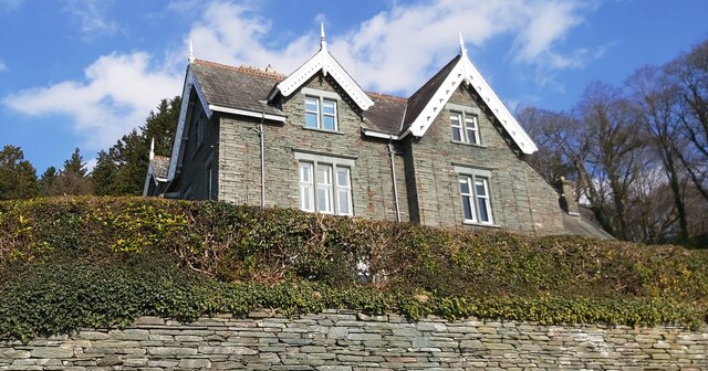
The village is characterized by its traditional stone houses and charming cottages, giving it a quintessential English countryside feel. The local community is small and close-knit, with a population of around 300 residents.

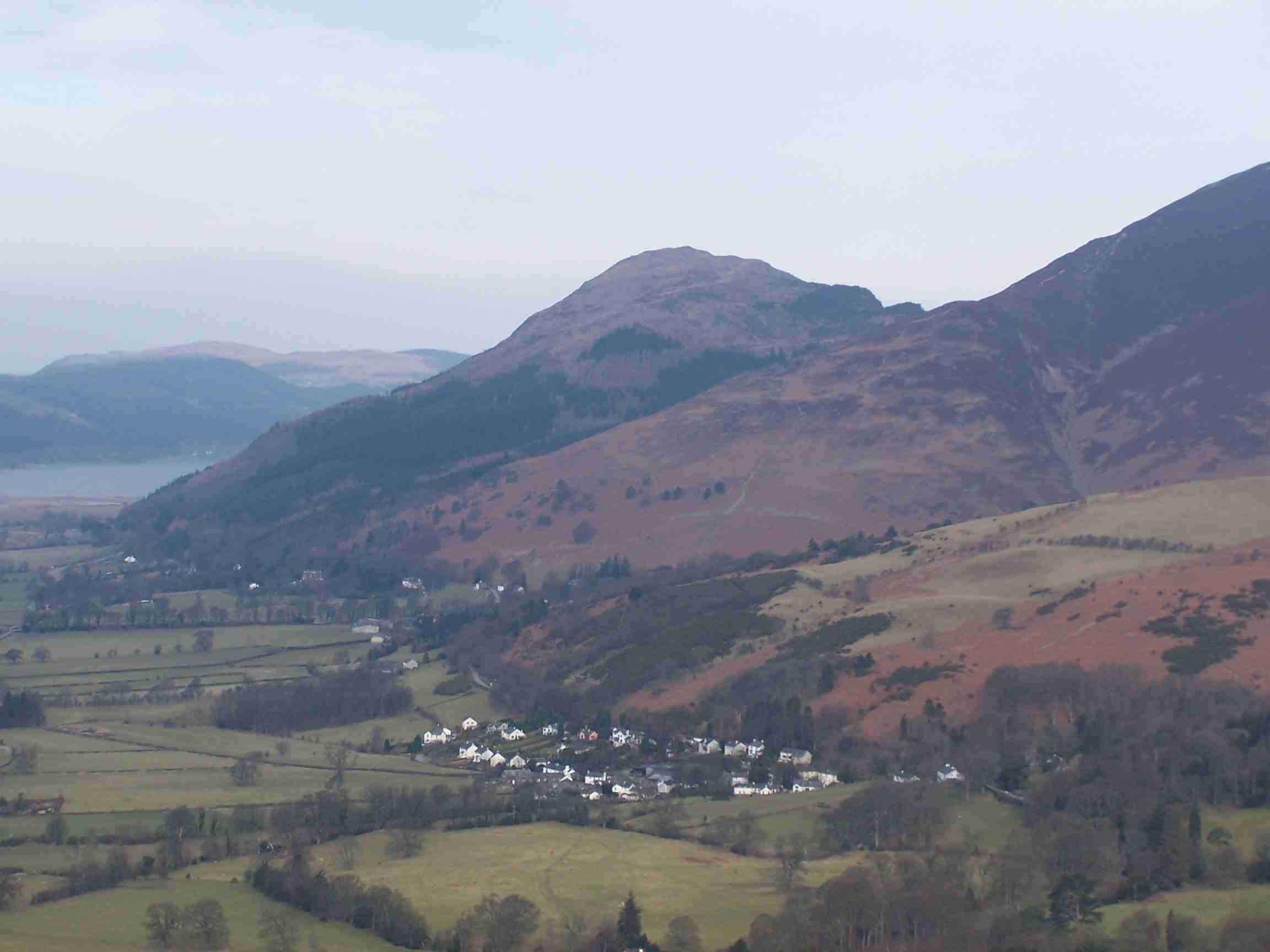
Millbeck is renowned for its lush green landscapes and rolling hills, offering breathtaking views of the surrounding mountains. The village is a haven for outdoor enthusiasts, with an extensive network of walking trails and hiking routes to explore. One popular trail is the ascent of Skiddaw, one of the highest peaks in the Lake District.

Despite its rural location, Millbeck is conveniently located near the market town of Keswick, which is just a short drive away. Keswick offers a range of amenities including shops, restaurants, and leisure facilities, providing residents with easy access to modern conveniences.

Millbeck also benefits from its proximity to Derwentwater, a stunning lake that offers opportunities for boating, fishing, and water sports. The lake is surrounded by woodlands and offers a serene escape for nature lovers.

In summary, Millbeck is a charming and picturesque village in Cumberland, offering a peaceful retreat in the heart of the Lake District. With its stunning natural landscapes and close proximity to Keswick and Derwentwater, it is an ideal destination for both residents and visitors seeking a rural escape.

If you have any feedback on the listing, please let us know in the comments section below.

Millbeck Images

Images are sourced within 2km of 54.625479/-3.150795 or Grid Reference NY2526. Thanks to Geograph Open Source API. All images are credited.

Information Board on Round How This information board beside The Cumbria Way features the adjacent 17 hectare (41 acre) Gale Ghyll Woods, a part of the Mirehouse Estate.
The Ordnance Survey spell Gale Ghyll as the traditional Gale Gill.  Ghyll was introduced as a fashionable alternative spelling in Victorian times.
Information Board on Round How
This information board beside The Cumbria Way features the adjacent 17 hectare (41 acre) Gale Ghyll Woods, a part of the Mirehouse Estate. The Ordnance Survey spell Gale Ghyll as the traditional Gale Gill. Ghyll was introduced as a fashionable alternative spelling in Victorian times.
The Cumbria Way, Round How The public bridleway from Briar Rigg to Latrigg Car Park is the route of The Cumbria Way and crosses open ground above Round How (next photograph <a href="https://www.geograph.org.uk/photo/6933208">NY2725 : The Cumbria Way above Round How</a>).
The information board (photograph <a href="https://www.geograph.org.uk/photo/6933018">NY2725 : Information Board on Round How</a>) features the 17 hectare (41 acre) Gale Ghyll Woods that lie below the bridleway between Round How and Latrigg Car Park.
The path leading steeply up to the right leads on to Mallen Dodd and ultimately to the summit of Latrigg; a more easily graded path can be gained by following the bridleway for a further 425m (470 yards).
The Cumbria Way, Round How
The public bridleway from Briar Rigg to Latrigg Car Park is the route of The Cumbria Way and crosses open ground above Round How (next photograph NY2725 : The Cumbria Way above Round How). The information board (photograph NY2725 : Information Board on Round How) features the 17 hectare (41 acre) Gale Ghyll Woods that lie below the bridleway between Round How and Latrigg Car Park. The path leading steeply up to the right leads on to Mallen Dodd and ultimately to the summit of Latrigg; a more easily graded path can be gained by following the bridleway for a further 425m (470 yards).
Path Junction above Round How The path leading to the left through the gate is a permitted bridleway through Gale Ghyll Woods; the main right hand path is the public bridleway from Briar Rigg to Latrigg Car Park and the route of The Cumbria Way (next photograph <a href="https://www.geograph.org.uk/photo/6933055">NY2725 : The Cumbria Way by Gale Ghyll Woods</a>).
Path Junction above Round How
The path leading to the left through the gate is a permitted bridleway through Gale Ghyll Woods; the main right hand path is the public bridleway from Briar Rigg to Latrigg Car Park and the route of The Cumbria Way (next photograph NY2725 : The Cumbria Way by Gale Ghyll Woods).
The Cumbria Way above Round How The Cumbria Way, a 74 mile long distance trail from Ulverston to Carlisle follows the public bridleway from Briar Rigg to Latrigg Car Park beside Gale Ghyll Woods (next photograph <a href="https://www.geograph.org.uk/photo/6933060">NY2725 : Path Junction above Round How</a>).
This is also a popular walking route from Keswick to the summit of Skiddaw.
The Cumbria Way above Round How
The Cumbria Way, a 74 mile long distance trail from Ulverston to Carlisle follows the public bridleway from Briar Rigg to Latrigg Car Park beside Gale Ghyll Woods (next photograph NY2725 : Path Junction above Round How). This is also a popular walking route from Keswick to the summit of Skiddaw.
A66 Keswick Bypass near Crosthwaite
Old Milestone, A591, Millbeck The milestone is located east of Crookelty Bridge, on the verge by the wall, on the north side of the road. Parish of Keswick (Allerdale District). Carved stone post, Cockermouth numeral design, erected by the Keswick turnpike trust in the 19th century.

Inscription reads:-
2

Milestone Society National ID: CU_KWCM02
Old Milestone, A591, Millbeck
The milestone is located east of Crookelty Bridge, on the verge by the wall, on the north side of the road. Parish of Keswick (Allerdale District). Carved stone post, Cockermouth numeral design, erected by the Keswick turnpike trust in the 19th century. Inscription reads:- 2 Milestone Society National ID: CU_KWCM02
The Path on Jenkin Hill
Tangled Iron on the Summit of Little Man
Deforested Hillside at Underscar
Hotel at Applethwaite
Carl Side
Carl Side
Direction Sign – Signpost off the A591 towards Applethwaite Located on the northeast side of the junction of the A591 with the unclassified road to Applethwaite, Underskiddaw parish. 1 arm and pawn finial. For an earlier photo, see <a title="https://www.geograph.org.uk/photo/6050873" href="https://www.geograph.org.uk/photo/6050873">Link</a>. See also <a title="https://www.geograph.org.uk/photo/6002015" href="https://www.geograph.org.uk/photo/6002015">Link</a>.

Milestone Society National ID: CU_NY2525A
Direction Sign – Signpost off the A591 towards Applethwaite
Located on the northeast side of the junction of the A591 with the unclassified road to Applethwaite, Underskiddaw parish. 1 arm and pawn finial. For an earlier photo, see Link. See also Link. Milestone Society National ID: CU_NY2525A
The North Western Fells from Carl Side ...

There are 29 fells listed by A Wainwright in his book The North Western Fells (first published sixty years ago) and this panorama from Carl Side near Skiddaw shows many of them.

On the lower ground, from left to right, are Derwentwater, Portinscale, Braithwaite, Thornthwaite and a small part of Bassenthwaite Lake. The nearby summit of Dodd, with its scattered trees, hides part of that lake.

On the left, with sunlit slopes overlooking Derwentwater, is that walkers' favourite, Cat Bells. Just right of centre, below the last fluffy cloud, is Grasmoor, at 852m the highest in the region. Thornthwaite Forest is the large area of trees to the right.

It is my intention, after further study, to identify more of the fells seen here. Details will be added in due course.

by David Purchase
The North Western Fells from Carl Side
... There are 29 fells listed by A Wainwright in his book The North Western Fells (first published sixty years ago) and this panorama from Carl Side near Skiddaw shows many of them. On the lower ground, from left to right, are Derwentwater, Portinscale, Braithwaite, Thornthwaite and a small part of Bassenthwaite Lake. The nearby summit of Dodd, with its scattered trees, hides part of that lake. On the left, with sunlit slopes overlooking Derwentwater, is that walkers' favourite, Cat Bells. Just right of centre, below the last fluffy cloud, is Grasmoor, at 852m the highest in the region. Thornthwaite Forest is the large area of trees to the right. It is my intention, after further study, to identify more of the fells seen here. Details will be added in due course. by David Purchase
Keswick Agricultural Show - Horse competition This traditional show is held on Bank Holiday Monday in August
Keswick Agricultural Show - Horse competition
This traditional show is held on Bank Holiday Monday in August
Horse event Keswick Show
Cumberland wrestling at Keswick Show
Rebuilt Path from Latrigg to Skiddaw Better than an eroded "motorway" but still a bit un-natural
Rebuilt Path from Latrigg to Skiddaw
Better than an eroded "motorway" but still a bit un-natural
Little Man on Skiddaw Threatening clouds on cold October day looking towards Little Man from Skiddaw
Little Man on Skiddaw
Threatening clouds on cold October day looking towards Little Man from Skiddaw
Show me another place!

Millbeck is located at Grid Ref: NY2526 (Lat: 54.625479, Lng: -3.150795)

Administrative County: Cumbria

District: Allerdale

Police Authority: Cumbria

What 3 Words

///iterative.subtitle.stop. Near Keswick, Cumbria

Nearby Locations

Millbeck

Related Wikis

Underscar Manor

Underscar Manor is a country house at Underskiddaw in Cumbria. It is a Grade II listed building. == History == The house was designed by Charles Verelst...

Dodd (Lake District)

Dodd is a small fell in the Lake District, Cumbria, England, four kilometres north-west of Keswick. It forms part of the Skiddaw range in the northern...

Skiddaw Little Man

Skiddaw Little Man also called Little Man is a fell in the English Lake District, it is situated four kilometres north of the town of Keswick and reaches...

Carl Side

Carl Side is a fell in the English Lake District, forming a part of the Skiddaw "family" near the town of Keswick and prominently visible from its streets...

Nearby Amenities

Located within 500m of 54.625479,-3.150795
Barrier: kissing_gate
Foot: yes
Lat/Long: 54.626127/-3.1545168
Barrier: stile
Foot: yes
Steps: 2
Lat/Long: 54.6277477/-3.1548225
Millbeck
Is In County: Cumbria
Place: hamlet
Source: npe
Lat/Long: 54.6247001/-3.1527678
Barrier: kissing_gate
Lat/Long: 54.6229535/-3.1533676
Post Box
Operator: Royal Mail
Operator Wikidata: Q638098
Post Box Type: wall
Ref: CA12 123
Royal Cypher: GR
Royal Cypher Wikidata: Q33102273
Source: survey
Lat/Long: 54.6246224/-3.1537081
Grit Bin
Lat/Long: 54.6247187/-3.1538605
Hazard: animal_crossing
Note: Red Squirrel Drive Slowly
Species: Sciurus vulgaris
Species En: Red squirrel
Species Fr: Écureuil roux
Traffic Sign: hazard
Lat/Long: 54.6261457/-3.1584624
Hiking: yes
Information: guidepost
Source: GPS Survey
Tourism: information
Lat/Long: 54.6256165/-3.1545724
Bench
Source: GPS Survey
Lat/Long: 54.6260128/-3.1566496
Barrier: stile
Material: wood
Source: survey;gps
Stile: stepover
Lat/Long: 54.6262152/-3.157363
Hiking: yes
Information: guidepost
Source: GPS Survey
Tourism: information
Lat/Long: 54.6260737/-3.1570097
Bench
Source: GPS Survey
Lat/Long: 54.6221564/-3.1472109
WW1 & WW2
Historic: memorial
Source: GPS Survey
Lat/Long: 54.6221688/-3.1473061
Bench
Lat/Long: 54.62341/-3.1521806
Barrier: stile
Lat/Long: 54.6229278/-3.1504093
Benny Crag
Place: locality
Lat/Long: 54.6273535/-3.155237
Doups
Place: locality
Lat/Long: 54.629176/-3.1551645
Give Way
Direction: backward
Lat/Long: 54.6247333/-3.1537089
Power: pole
Lat/Long: 54.6214461/-3.1521699
Power: pole
Lat/Long: 54.622341/-3.1535636
Power: pole
Lat/Long: 54.6231944/-3.1549117
Power: pole
Lat/Long: 54.6242237/-3.1565377
Power: pole
Lat/Long: 54.6248772/-3.1575775
Power: pole
Lat/Long: 54.6254377/-3.1571151
Power: pole
Lat/Long: 54.6260623/-3.1566636
Power: pole
Lat/Long: 54.6239862/-3.1536222
Power: pole
Lat/Long: 54.6227231/-3.1562837
The data included in this document is from www.openstreetmap.org. The data is made available under ODbL.

Have you been to Millbeck?

Leave your review of Millbeck below (or comments, questions and feedback).