Tuilyies

Heritage Site in Fife

Scotland

Tuilyies

Main Street, Newmills
Main Street, Newmills Credit: David Brown

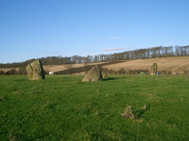
Tuilyies, located in Fife, Scotland, is a historically significant site that holds great importance in the region's heritage. The site is home to a collection of standing stones, which are believed to date back to the Neolithic era, around 3000 BC. These stones, known as the Tuilyies Stones, are a testament to the ancient civilizations that once inhabited the area.

The Tuilyies Stones are arranged in a circular formation, with the largest stone standing at approximately 2.7 meters tall. The purpose of these stones remains somewhat of a mystery, with theories ranging from religious rituals to astronomical observations. However, their significance as a cultural and historical artifact cannot be denied.

In addition to the standing stones, Tuilyies also features a burial mound, known as a cairn, which is believed to be from the Bronze Age. Excavations in the past have uncovered human remains and other artifacts, shedding light on the practices and customs of the people who lived in the area thousands of years ago.

The site is open to the public, allowing visitors to explore and appreciate the ancient history of Tuilyies. Interpretive panels provide information about the site's significance, offering a glimpse into the lives of the people who once inhabited the area. Tuilyies serves as a valuable educational resource, offering a unique opportunity to connect with the past and learn about the rich heritage of Fife.

Overall, Tuilyies is a fascinating heritage site that showcases the ancient history of Fife. The standing stones and burial mound provide a tangible link to the past, offering a unique insight into the lives and customs of the people who once called this area home.

If you have any feedback on the listing, please let us know in the comments section below.

Tuilyies Images

Images are sourced within 2km of 56.062/-3.567 or Grid Reference NT0286. Thanks to Geograph Open Source API. All images are credited.

Main Street, Newmills
A985 north of Newmills, Fife
Garden and fields at Inzievar
Stubble near Oakley
Stubble near Oakley
Torry Bay Bird Hide Part of an artistic bird hide on the edge of one of the ash lagoons of Torry Bay Nature Reserve near Culross in Fife.
Torry Bay Bird Hide
Part of an artistic bird hide on the edge of one of the ash lagoons of Torry Bay Nature Reserve near Culross in Fife.
Bird Hide Detail Well this bird is not hiding very well! - One of the bird shaped openings for viewing on a bird hide at Torry Bay Nature Reserve near Culross Fife.
Bird Hide Detail
Well this bird is not hiding very well! - One of the bird shaped openings for viewing on a bird hide at Torry Bay Nature Reserve near Culross Fife.
Disused cottages at Bullions On the road to Crombie Point.
Disused cottages at Bullions
On the road to Crombie Point.
The view from Bullions Looking west across the Firth of Forth to Grangemouth.
The view from Bullions
Looking west across the Firth of Forth to Grangemouth.
Winter wheat near Bullions Looking north along the line of the power supply.
Winter wheat near Bullions
Looking north along the line of the power supply.
The road to Crombie Point Trees silhouetted against the clouds of storm Gertrude.
The road to Crombie Point
Trees silhouetted against the clouds of storm Gertrude.
Stubble field with trees Looking north from the road to Crombie Point.
Stubble field with trees
Looking north from the road to Crombie Point.
Footpath in Torry Bay Nature Reserve Looking east along part of the circular walk around the ash lagoons that comprise the Torry Bay Nature Reserve,
Footpath in Torry Bay Nature Reserve
Looking east along part of the circular walk around the ash lagoons that comprise the Torry Bay Nature Reserve,
Railway at Low Valleyfield Looking east along the line that serves Longannet Power Station. For an autumn view from the same spot 6 years earlier see Richard Webb's <a href="https://www.geograph.org.uk/photo/1881034">NT0086 : Railway, Low Valleyfield</a>.
Railway at Low Valleyfield
Looking east along the line that serves Longannet Power Station. For an autumn view from the same spot 6 years earlier see Richard Webb's NT0086 : Railway, Low Valleyfield.
Footpath and NCN sign at Valleyfield The Fife Coastal Path and NCN76 pass this way; Preston Island Circular goes round the perimeter [mostly] of the ash lagoons and Torry Bay Nature Reserve.
Footpath and NCN sign at Valleyfield
The Fife Coastal Path and NCN76 pass this way; Preston Island Circular goes round the perimeter [mostly] of the ash lagoons and Torry Bay Nature Reserve.
Torry Bay The marine part of the nature reserve. The fence is part of the ash lagoon boundary.
Torry Bay
The marine part of the nature reserve. The fence is part of the ash lagoon boundary.
Torry Pier The name on the map for the emergent rocks in Torry Bay, but I do not know if it has ever been part of such a structure.
Torry Pier
The name on the map for the emergent rocks in Torry Bay, but I do not know if it has ever been part of such a structure.
Torry Bay from near Preston Island Part of the complex of ash lagoons built up from the ash slurry from Longannet power station.
Torry Bay from near Preston Island
Part of the complex of ash lagoons built up from the ash slurry from Longannet power station.
Tuilyies Standing Stones The name "Tuilyies" is a corruption of the Scottish word "tulzie" signifying a fight. The stones are said to mark the graves of chieftains who died here in an alleged battle.
Tuilyies Standing Stones
The name "Tuilyies" is a corruption of the Scottish word "tulzie" signifying a fight. The stones are said to mark the graves of chieftains who died here in an alleged battle.
Show me another place!

Tuilyies is located at Grid Ref: NT0286 (Lat: 56.062, Lng: -3.567)

Unitary Authority: Fife

Police Authority: Fife

What 3 Words

///beauty.alternate.abruptly. Near Cairneyhill, Fife

Related Wikis

Torryburn railway station

Torryburn railway station served the village of Torryburn, Fife, Scotland from 1906 to 1930 on the Kincardine Line. == History == The station was opened...

Oakley, Fife

Oakley is a village in Fife, Scotland located at the mutual border of Carnock and Culross parishes, Fife, 5+1⁄2 miles (9 kilometres) west of Dunfermline...

Cairneyhill railway station

Cairneyhill railway station served the village of Cairneyhill, Fife, Scotland from 1906 to 1930 on the Kincardine Line. == History == The station opened...

Torryburn

Torryburn (previously called Torry/ Torrie) is a village and parish in Fife, Scotland, lying on the north shore of the Firth of Forth. It is one of a number...

Cairneyhill

Cairneyhill is a village in West Fife, Scotland. It is 3 miles west of Dunfermline, on the A994, and has a population of around 2,510 (mid-2020 est.)The...

Oakley (Fife) railway station

Oakley (Fife) railway station served the village of Oakley, Fife, Scotland from 1850 to 1986 on the Stirling and Dunfermline Railway. == History == The...

Preston Island

Preston Island is a former artificial island in the Firth of Forth, Scotland. The reclaimed land was once used for salt production, using local coal. It...

Valleyfield, Fife

Valleyfield consists of High Valleyfield and Low Valleyfield which are neighbouring villages in Fife, Scotland, midway between Dunfermline and Kincardine...

Nearby Amenities

Located within 500m of 56.062,-3.567
Torryburn
Place: village
Source: npe
Wikidata: Q3995788
Wikipedia: en:Torryburn
Lat/Long: 56.0576004/-3.5674876
Post Box
Brand: Royal Mail
Brand Wikidata: Q638098
Brand Wikipedia: en:Royal Mail
Collection Times: Mo-Fr 17:15; Sa 11:45
Operator: Royal Mail
Operator Wikidata: Q638098
Post Box Type: wall
Ref: KY12 161
Royal Cypher: GVIR
Royal Cypher Wikidata: Q33102169
Lat/Long: 56.0579346/-3.5686163
Bus Stop
Eilean Lane
Bench: no
Naptan AtcoCode: 6500D0601
Naptan NaptanCode: 34323946
Shelter: no
Lat/Long: 56.0578255/-3.56871
Booth: K6
Covered: booth
Disused Amenity: telephone
Man Made: telephone_box
Lat/Long: 56.0579281/-3.5684768
Bus Stop
Eilean Lane
Bin: yes
Naptan AtcoCode: 6500D0600
Naptan NaptanCode: 34323952
Shelter: yes
Lat/Long: 56.0579506/-3.5687784
Bus Stop
Parish Church
Bench: no
Shelter: no
Lat/Long: 56.0580103/-3.5652132
Parking
Access: yes
Fee: no
Parking: layby
Source: Bing
Lat/Long: 56.0627457/-3.5611101
Parking
Access: yes
Fee: no
Parking: layby
Source: Bing
Lat/Long: 56.0636565/-3.5724138
Bus Stop
Parish Church
Bus: yes
Departures Board: timetable
Naptan AtcoCode: 6500D1065
Naptan NaptanCode: 34323947
Network: Fife
Operator: Stagecoach
Public Transport: platform
Surface: tactile_paving
Lat/Long: 56.0579084/-3.5652831
Torryburn
Historic Railway: station
Railway: site
Wikidata: Q79802684
Wikipedia: en:Torryburn railway station
Lat/Long: 56.0589988/-3.5723488
Power: pole
Lat/Long: 56.0587678/-3.5617611
Power: pole
Lat/Long: 56.0584711/-3.5630487
Power: pole
Lat/Long: 56.0584809/-3.5653561
Power: pole
Lat/Long: 56.0584732/-3.564049
Power: pole
Lat/Long: 56.0585932/-3.5662197
Power: pole
Lat/Long: 56.0587089/-3.5670931
Power: pole
Lat/Long: 56.0588583/-3.5681892
Power: pole
Lat/Long: 56.0585692/-3.568281
Tuilyies Standing Stones
Access: permissive
Archaeological Site: megalith
Historic: archaeological_site
Historic Civilization: prehistoric
Wikidata: Q73118027
Wikimedia Commons: Category:Tuilyies_Standing_Stones
Lat/Long: 56.0623652/-3.5608362
Power: pole
Lat/Long: 56.0589546/-3.5695658
Power: pole
Lat/Long: 56.0590519/-3.5709568
Waste Basket
Lat/Long: 56.0627239/-3.5610888
Addr Housenumber: 114-120
Addr Street: Main Street
Lat/Long: 56.0583272/-3.5712259
Addr Housenumber: 78
Addr Street: Main Street
Lat/Long: 56.0581724/-3.5696087
Addr Housenumber: 76
Addr Street: Main Street
Lat/Long: 56.0581419/-3.569466
Addr Housenumber: 74
Addr Street: Main Street
Lat/Long: 56.0581484/-3.5693263
Addr Housenumber: 72
Addr Street: Main Street
Lat/Long: 56.0581543/-3.5691994
Addr Housenumber: 70
Addr Street: Main Street
Lat/Long: 56.0581475/-3.5690209
Addr Housenumber: 68
Addr Street: Main Street
Lat/Long: 56.058093/-3.5690091
Addr Housenumber: 66
Addr Street: Main Street
Lat/Long: 56.0580377/-3.5689971
Addr Housenumber: 64
Addr Street: Main Street
Lat/Long: 56.0579345/-3.5685544
Addr Housename: Craigmyle
Addr Housenumber: 62
Addr Street: Main Street
Lat/Long: 56.057957/-3.5682321
Addr Housenumber: 60
Addr Street: Main Street
Lat/Long: 56.0579634/-3.5680582
Addr Housename: The School House
Addr Housenumber: 58
Addr Street: Main Street
Lat/Long: 56.0579757/-3.5678428
Addr Housenumber: 56
Addr Street: Main Street
Lat/Long: 56.0579797/-3.5676294
Addr Housenumber: 54
Addr Street: Main Street
Lat/Long: 56.0579837/-3.5674532
Addr Housenumber: 52
Addr Street: Main Street
Lat/Long: 56.0579914/-3.5673489
Addr Housenumber: 50
Addr Street: Main Street
Lat/Long: 56.0579986/-3.5672522
Addr Housenumber: 8
Addr Street: Orchard Terrace
Lat/Long: 56.0580686/-3.567059
Addr Housenumber: 7
Addr Street: Orchard Terrace
Lat/Long: 56.058072/-3.566888
Addr Housenumber: 6
Addr Street: Orchard Terrace
Lat/Long: 56.0580732/-3.5668305
Addr Housenumber: 5
Addr Street: Orchard Terrace
Lat/Long: 56.0580765/-3.5666654
Addr Housenumber: 4
Addr Street: Orchard Terrace
Lat/Long: 56.0581385/-3.5664395
Addr Housenumber: 3
Addr Street: Orchard Terrace
Lat/Long: 56.0581436/-3.5662625
Addr Housenumber: 2
Addr Street: Orchard Terrace
Lat/Long: 56.0581422/-3.5659929
Addr Housenumber: 1
Addr Street: Orchard Terrace
Lat/Long: 56.0581475/-3.5658078
The data included in this document is from www.openstreetmap.org. The data is made available under ODbL.

Have you been to Tuilyies ?

Leave your review of Tuilyies below (or comments, questions and feedback).