Stanton Hall

Heritage Site in Northumberland

England

Stanton Hall

Nunriding Hall Nunriding Hall was built in at least the 17th century (if not earlier). It was remodelled in the mid 18th century. It has since been divided into three parts. These are Grade II Listed Buildings protected by law.
Nunriding Hall Credit: Les Hull

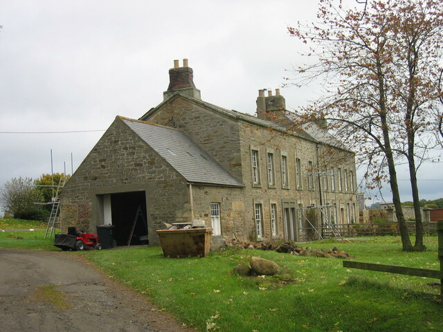
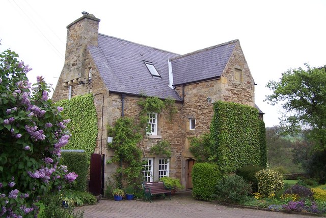
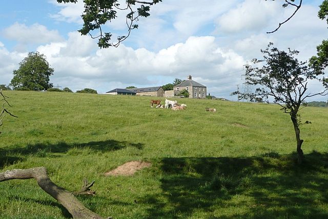
Stanton Hall, located in Northumberland, is a remarkable heritage site that offers visitors a glimpse into the rich history and architectural grandeur of the region. This magnificent country house was originally built in the 18th century and has since become a symbol of elegance and opulence.

The hall is known for its stunning Georgian architecture, characterized by its symmetrical design, grand proportions, and ornate detailing. The exterior of the building features a beautiful Palladian-style facade, with its distinctive columns, large windows, and intricate stonework. The interior of Stanton Hall is equally impressive, boasting lavish reception rooms, a grand staircase, and beautifully decorated ceilings.

Visitors to Stanton Hall can explore the various rooms and wings, each offering a unique glimpse into the lives of the Hall's past occupants. The hall is home to an extensive collection of period furniture, artwork, and historical artifacts, providing a captivating insight into the bygone era.

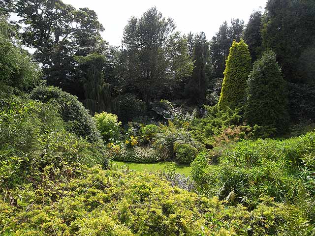
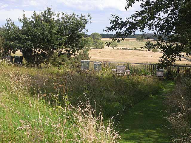
Surrounded by meticulously manicured gardens and sprawling parkland, Stanton Hall offers visitors the opportunity to enjoy a leisurely stroll and take in the picturesque surroundings. The gardens are adorned with vibrant flower beds, ornamental statues, and tranquil water features, creating a serene and idyllic atmosphere.

Stanton Hall is not only a popular tourist attraction but also serves as a venue for various cultural events and exhibitions. It provides a stunning backdrop for weddings, corporate functions, and other special occasions.

In conclusion, Stanton Hall is a magnificent heritage site that showcases the architectural brilliance and cultural significance of Northumberland. With its stunning Georgian design, opulent interiors, and serene surroundings, it offers visitors a truly immersive experience into the region's rich history.

If you have any feedback on the listing, please let us know in the comments section below.

Stanton Hall Images

Images are sourced within 2km of 55.2/-1.788 or Grid Reference NZ1389. Thanks to Geograph Open Source API. All images are credited.

Nunriding Hall Nunriding Hall was built in at least the 17th century (if not earlier). It was remodelled in the mid 18th century. It has since been divided into three parts. These are Grade II Listed Buildings protected by law.
Nunriding Hall
Nunriding Hall was built in at least the 17th century (if not earlier). It was remodelled in the mid 18th century. It has since been divided into three parts. These are Grade II Listed Buildings protected by law.
Footbridge over the River Font
Looking towards the Cheviots from Stanton.
Witton Shields Tower The Gatehouse Web Site: King writes this is a C17 domestic building, not a fortified tower. Dodds writes it is a late strong house. PastScape report it as "A bastle or fortified house, probably built in the early C17. A stone inscribed with the date 1608 and the initials N T (Nigel Thornton) is set above the door. The rear extensions were added in 1680 and the building was reduced in height by a storey circa 1914. One of the upper rooms of the house was used as a Roman Catholic chapel in the early C17. The house stands in pastureland, overlooking the dene of the Cowclose Burn on the north side, and the valley of the River Font to the south. It is a strongly constructed building of two storeys with a central stair turret and walls 1 metre thick. The rectangular building is built of stone rubble, with a slate roof." Recorded in survey of 1715 as "a large old building bellonging to Jon. Thornton, esq." SMR report that it is possible there was once a small watchtower on the western side of the roof.
Witton Shields Tower
The Gatehouse Web Site: King writes this is a C17 domestic building, not a fortified tower. Dodds writes it is a late strong house. PastScape report it as "A bastle or fortified house, probably built in the early C17. A stone inscribed with the date 1608 and the initials N T (Nigel Thornton) is set above the door. The rear extensions were added in 1680 and the building was reduced in height by a storey circa 1914. One of the upper rooms of the house was used as a Roman Catholic chapel in the early C17. The house stands in pastureland, overlooking the dene of the Cowclose Burn on the north side, and the valley of the River Font to the south. It is a strongly constructed building of two storeys with a central stair turret and walls 1 metre thick. The rectangular building is built of stone rubble, with a slate roof." Recorded in survey of 1715 as "a large old building bellonging to Jon. Thornton, esq." SMR report that it is possible there was once a small watchtower on the western side of the roof.
Witton Shields Tower King writes this is a C17 domestic building, not a fortified tower. Dodds writes it is a late strong house. PastScape report it as "A bastle or fortified house, probably built in the early C17. A stone inscribed with the date 1608 and the initials N T (Nigel Thornton) is set above the door. The rear extensions were added in 1680 and the building was reduced in height by a storey circa 1914. One of the upper rooms of the house was used as a Roman Catholic chapel in the early C17. The house stands in pastureland, overlooking the dene of the Cowclose Burn on the north side, and the valley of the River Font to the south. It is a strongly constructed building of two storeys with a central stair turret and walls 1 metre thick. The rectangular building is built of stone rubble, with a slate roof." Recorded in survey of 1715 as "a large old building bellonging to Jon. Thornton, esq." SMR report that it is possible there was once a small watchtower on the western side of the roof.
Witton Shields Tower
King writes this is a C17 domestic building, not a fortified tower. Dodds writes it is a late strong house. PastScape report it as "A bastle or fortified house, probably built in the early C17. A stone inscribed with the date 1608 and the initials N T (Nigel Thornton) is set above the door. The rear extensions were added in 1680 and the building was reduced in height by a storey circa 1914. One of the upper rooms of the house was used as a Roman Catholic chapel in the early C17. The house stands in pastureland, overlooking the dene of the Cowclose Burn on the north side, and the valley of the River Font to the south. It is a strongly constructed building of two storeys with a central stair turret and walls 1 metre thick. The rectangular building is built of stone rubble, with a slate roof." Recorded in survey of 1715 as "a large old building bellonging to Jon. Thornton, esq." SMR report that it is possible there was once a small watchtower on the western side of the roof.
Footbridge over the Cow Close Burn at Witton Shields
Huge Beech with 20ft Bole
High Trewitley farm
High Trewitley farm
Townhead Farm, Stanton
Gallowshaw A cattle grazing area in front of the property of Gallowshaw, which is for sale if you are interested.
Gallowshaw
A cattle grazing area in front of the property of Gallowshaw, which is for sale if you are interested.
Ploughed field at Abshield Recently ploughed field in autumn.
Ploughed field at Abshield
Recently ploughed field in autumn.
Farm road from Abshields to Berryhill Although just a farm road, carries the status of a public road, theoretically open to all traffic.
Farm road from Abshields to Berryhill
Although just a farm road, carries the status of a public road, theoretically open to all traffic.
Abshields Farm Looking across a freshly-ploughed field.
Abshields Farm
Looking across a freshly-ploughed field.
Entrance to Bide-a-Wee Cottage Gardens The entrance and plant sales area of Bide-a-Wee Cottage Gardens <span class="nowrap"><a title="http://www.bideawee.co.uk/" rel="nofollow ugc noopener" href="http://www.bideawee.co.uk/">Link</a><img style="margin-left:2px;" alt="External link" title="External link - shift click to open in new window" src="https://s1.geograph.org.uk/img/external.png" width="10" height="10"/></span> , an impressive and immaculately kept garden open to the public two afternoons a week.
Entrance to Bide-a-Wee Cottage Gardens
The entrance and plant sales area of Bide-a-Wee Cottage Gardens LinkExternal link , an impressive and immaculately kept garden open to the public two afternoons a week.
Bide-a-Wee Cottage Gardens Bide-a-Wee Cottage Gardens <span class="nowrap"><a title="http://www.bideawee.co.uk/" rel="nofollow ugc noopener" href="http://www.bideawee.co.uk/">Link</a><img style="margin-left:2px;" alt="External link" title="External link - shift click to open in new window" src="https://s1.geograph.org.uk/img/external.png" width="10" height="10"/></span> , an impressive and immaculately kept garden open to the public two afternoons a week. The gardens have been developed on the site of a former quarry over the course of the last twenty five years.
Bide-a-Wee Cottage Gardens
Bide-a-Wee Cottage Gardens LinkExternal link , an impressive and immaculately kept garden open to the public two afternoons a week. The gardens have been developed on the site of a former quarry over the course of the last twenty five years.
Beehives at Bide-a-Wee Cottage Gardens Tucked away beyond the visitor area of Bide-a-Wee Cottage Gardens, these beehives overlook open farmland.
Beehives at Bide-a-Wee Cottage Gardens
Tucked away beyond the visitor area of Bide-a-Wee Cottage Gardens, these beehives overlook open farmland.
Old piece of agricultural equipment A disused cattle Crush
Old piece of agricultural equipment
A disused cattle Crush
Cut line through Broadmeadow Wood A corridor through  Broadmeadow Wood, a plantation of Scots Pine, to make way for overhead power lines. The corridor is now occupied by young birch trees.
Cut line through Broadmeadow Wood
A corridor through Broadmeadow Wood, a plantation of Scots Pine, to make way for overhead power lines. The corridor is now occupied by young birch trees.
Show me another place!

Stanton Hall is located at Grid Ref: NZ1389 (Lat: 55.2, Lng: -1.788)

Unitary Authority: Northumberland

Police Authority: Northumbria

What 3 Words

///cheat.residual.purified. Near Longhorsley, Northumberland

Nearby Locations

Stanton Hall Stanton

Related Wikis

Stanton, Northumberland

Stanton is a small hamlet and former civil parish, now in the parish of Netherwitton, in Northumberland, England, which is located 7 miles (11 km) north...

Pigdon

Pigdon is a hamlet and former civil parish 3 miles (4.8 km) from Morpeth, now in the parish of Meldon, in the county of Northumberland, England. In 1951...

Netherwitton

Netherwitton is a village in Northumberland, England about 8 miles (13 km) west north west of Morpeth. A former cotton-mill now converted into residential...

Netherwitton Hall

Netherwitton Hall is a mansion house, and a Grade I listed building at Netherwitton, near Morpeth, Northumberland, England.The estate was owned by the...

Meldon Park

Meldon Park is a privately owned country mansion situated at Meldon, Northumberland. It is a Grade II* listed building. == Present building == In 1832...

Mitford Hall

Mitford Hall is a Georgian mansion house and Grade II* listed building standing in its own 85-acre (34 ha) park overlooking the River Wansbeck at Mitford...

Longhorsley

Longhorsley is a village in Northumberland, England about 7 miles (11 km) northwest of Morpeth, and about 14 miles (23 km) south of Alnwick. The A697 road...

Mitford Old Manor House

Mitford Old Manor House is an historic English manor house at Mitford, Northumberland, and is a Grade II* listed building. The Manor of Mitford was held...

Nearby Amenities

Located within 500m of 55.2,-1.788
Power: pole
Lat/Long: 55.196933/-1.7908759
Power: pole
Lat/Long: 55.1979717/-1.7905988
Power: pole
Lat/Long: 55.1989952/-1.7903258
Power: pole
Lat/Long: 55.2000892/-1.7900339
Power: pole
Lat/Long: 55.2010826/-1.7897689
Power: pole
Lat/Long: 55.2020818/-1.7895023
Power: pole
Lat/Long: 55.2030788/-1.7892363
Power: pole
Lat/Long: 55.2041086/-1.7889261
The data included in this document is from www.openstreetmap.org. The data is made available under ODbL.

Have you been to Stanton Hall?

Leave your review of Stanton Hall below (or comments, questions and feedback).