Mere Hall

Heritage Site in Worcestershire Wychavon

England

Mere Hall

Farmland near Shell Farmland to the west of Shell.
Farmland near Shell Credit: Philip Halling

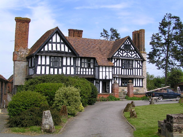
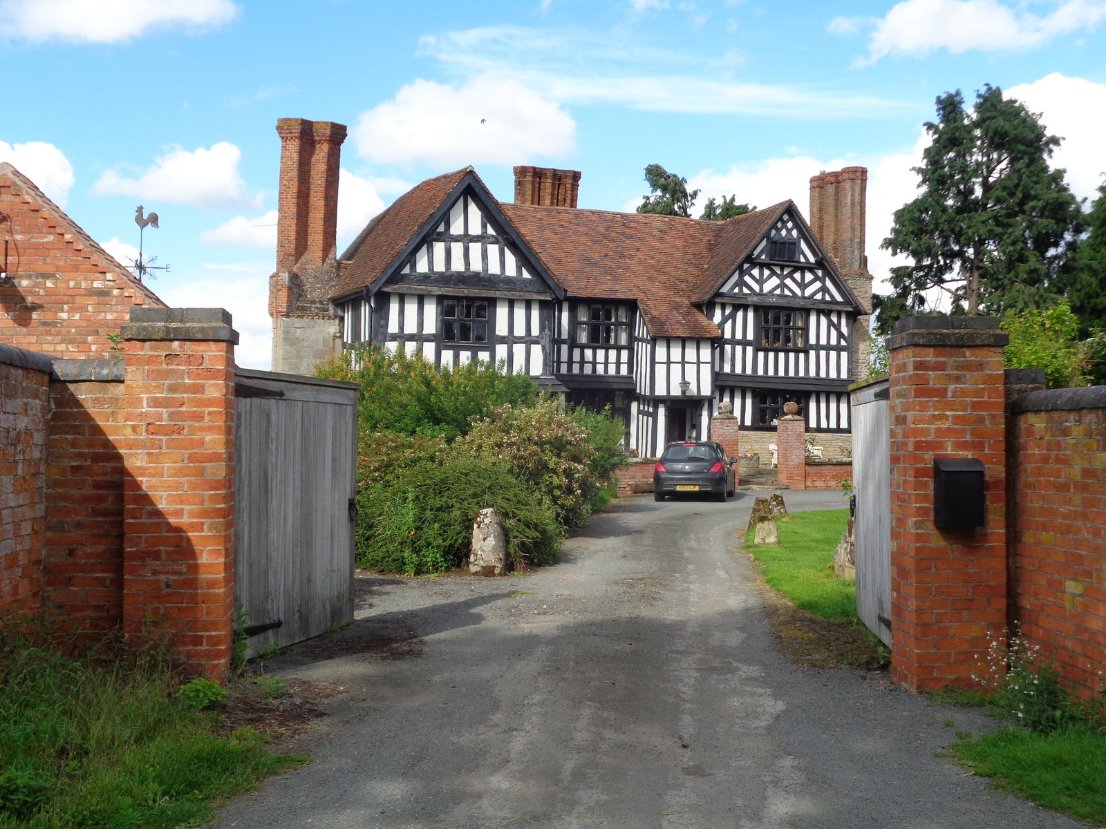
Mere Hall, located in Worcestershire, England, is a historic heritage site that dates back to the 14th century. This Grade II* listed building stands as a testament to the region's rich architectural and cultural heritage. Originally constructed as a manor house, Mere Hall has undergone several transformations throughout its history, resulting in its current stunning appearance.

The hall features a distinctive timber-framed structure, showcasing intricate Tudor-style craftsmanship. The exterior is adorned with ornate carvings and decorative elements, including gables and a beautiful timber porch. The building's steeply pitched roof is covered with traditional clay tiles, adding to its charm.

Inside, visitors can explore the hall's well-preserved historic interiors. The main hall boasts a grand fireplace, oak-paneled walls, and a stunning ceiling adorned with intricate plasterwork. Other notable features include a medieval-style chapel, a well-preserved library, and a collection of antique furniture and artwork.

Surrounding the hall is a picturesque landscape, featuring well-manicured gardens and a tranquil lake. The gardens are dotted with ancient trees and vibrant flower beds, providing a perfect setting for leisurely strolls or peaceful picnics.

Mere Hall is not only admired for its architectural and natural beauty but also for its historical significance. Over the centuries, it has been associated with several notable families and played a role in various historical events. Today, it stands as a cherished heritage site, offering visitors a glimpse into Worcestershire's past and a chance to immerse themselves in a truly enchanting setting.

If you have any feedback on the listing, please let us know in the comments section below.

Mere Hall Images

Images are sourced within 2km of 52.252/-2.067 or Grid Reference SO9561. Thanks to Geograph Open Source API. All images are credited.
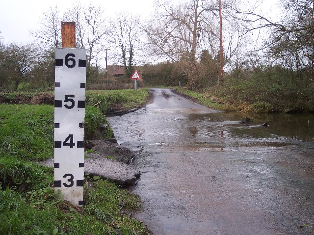
Farmland near Shell Farmland to the west of Shell.
Farmland near Shell
Farmland to the west of Shell.
Ford at Shell The ford close to the hamlet of Shell
Ford at Shell
The ford close to the hamlet of Shell
Picnic Site at Shell The small [1 table!] picnic site and footbridge at Shell beside the ford
Picnic Site at Shell
The small [1 table!] picnic site and footbridge at Shell beside the ford
Shell Ford This ford on the Shell Brook was two and a half foot deep at the time of my visit as can be seen in the video:
<span class="nowrap"><a title="http://www.youtube.com/watch?v=p7t1kvldoZU" rel="nofollow ugc noopener" href="http://www.youtube.com/watch?v=p7t1kvldoZU">Link</a><img style="margin-left:2px;" alt="External link" title="External link - shift click to open in new window" src="https://s1.geograph.org.uk/img/external.png" width="10" height="10"/></span>
Shell Ford
This ford on the Shell Brook was two and a half foot deep at the time of my visit as can be seen in the video: LinkExternal link
Shell Manor Farm. Shell Manor, a fine timbered house with work dating from the 14th to 16th century
Shell Manor Farm.
Shell Manor, a fine timbered house with work dating from the 14th to 16th century
Pedestrian Bridge by Shell Ford A warning notice, in these days of blame culture, reads "No Safety Rails On Bridge", "Cyclists Dismount" and "Pedestrians Please Take Care".
Pedestrian Bridge by Shell Ford
A warning notice, in these days of blame culture, reads "No Safety Rails On Bridge", "Cyclists Dismount" and "Pedestrians Please Take Care".
Shell Ford The water indicator is in feet. Looking west. For more information see:
<span class="nowrap"><a title="http://vamp.idlers.org/~jaffa/worcestershire.htm#shellford" rel="nofollow ugc noopener" href="http://vamp.idlers.org/~jaffa/worcestershire.htm#shellford">Link</a><img style="margin-left:2px;" alt="External link" title="External link - shift click to open in new window" src="https://s1.geograph.org.uk/img/external.png" width="10" height="10"/></span> 
 or 
<span class="nowrap"><a title="http://worcestershire.whub.org.uk/home/wccindex/wcc-countryside/wcc-countryside-sites.htm" rel="nofollow ugc noopener" href="http://worcestershire.whub.org.uk/home/wccindex/wcc-countryside/wcc-countryside-sites.htm">Link</a><img style="margin-left:2px;" alt="External link" title="External link - shift click to open in new window" src="https://s1.geograph.org.uk/img/external.png" width="10" height="10"/></span>
Shell Ford
The water indicator is in feet. Looking west. For more information see: LinkExternal link or LinkExternal link
Shell Ford Shell Ford near Earl's Common viewed from the pedestrian footbridge.  This is one of a number of fords crossing Shell Brook.
Shell Ford
Shell Ford near Earl's Common viewed from the pedestrian footbridge. This is one of a number of fords crossing Shell Brook.
Shell Manor Shell Manor is one of a number of impressive half-timbered manor houses in this area of Worcestershire.
Shell Manor
Shell Manor is one of a number of impressive half-timbered manor houses in this area of Worcestershire.
Road junction, Shell The sign on the left warns of Shell Ford a couple of hundred metres down the road.
Road junction, Shell
The sign on the left warns of Shell Ford a couple of hundred metres down the road.
Country road near Shell A milepost can be seen in the hedge on the left.
Country road near Shell
A milepost can be seen in the hedge on the left.
Milepost near Shell 'To Worcester Cross 9 Miles'
Milepost near Shell
'To Worcester Cross 9 Miles'
Collapsed building, Shell Only the roof remains and that doesn't look too good.
Collapsed building, Shell
Only the roof remains and that doesn't look too good.
Part of Shell Manor Farm
Shell Ford and foot bridge I'm stood on the very edge of the ford looking towards the foot bridge. There is a picnic area on the extreme left.
Shell Ford and foot bridge
I'm stood on the very edge of the ford looking towards the foot bridge. There is a picnic area on the extreme left.
Mere Green Farmhouse Grade II Listed. Listed as in Hanbury ward. The view from the public road. There are two further listed buildings in the complex but there are no good trespass free views.
Mere Green Farmhouse
Grade II Listed. Listed as in Hanbury ward. The view from the public road. There are two further listed buildings in the complex but there are no good trespass free views.
Mere Green Farmhouse Grade II Listed. This was the best view I could manage from a public place. The complex includes two further listed buildings but I could not get a meaningful view of those from public places.
Mere Green Farmhouse
Grade II Listed. This was the best view I could manage from a public place. The complex includes two further listed buildings but I could not get a meaningful view of those from public places.
Well Cottage, Hanbury A 17th century house with a thatched roof, Listed Grade II.
Well Cottage, Hanbury
A 17th century house with a thatched roof, Listed Grade II.
Show me another place!

Mere Hall is located at Grid Ref: SO9561 (Lat: 52.252, Lng: -2.067)

Administrative County: Worcestershire

District: Wychavon

Police Authority: West Mercia

What 3 Words

///jacket.trickling.perch. Near Stoke Prior, Worcestershire

Related Wikis

Mere Green, Worcestershire

Mere Green is a hamlet in the English county of Worcestershire. It is located south of the village of Hanbury roughly midway between Worcester and Redditch...

Shell, Worcestershire

Shell is a hamlet in the civil parish of Himbleton, in the Wychavon district, in the county of Worcestershire, England. It is 7 miles from Worcester. In...

Hanbury, Worcestershire

Hanbury is a rural village in Worcestershire, England near Droitwich Spa and the M5 motorway. The population of Hanbury has remained around 1,000 since...

Earls Common

Earls Common is a village in Worcestershire, England. Villages nearby include Himbleton and Stock Green.

Nearby Amenities

Located within 500m of 52.252,-2.067
Post Box
Collection Times: Mo-Fr 16:00; Sa 09:00
Post Box Type: lamp
Ref: WR9 339
Royal Cypher: EIIR
Royal Cypher Wikidata: Q33102113
Lat/Long: 52.2487372/-2.0657656
Power: pole
Lat/Long: 52.2486623/-2.0701708
Power: pole
Lat/Long: 52.2523867/-2.0694588
Little Lodge Poultry Unit
Power: pole
Transformer: distribution
Voltage Primary: 11000
Lat/Long: 52.2512769/-2.0673343
Mere Hall
Power: pole
Transformer: distribution
Voltage Primary: 11000
Lat/Long: 52.254134/-2.0727979
Power: pole
Lat/Long: 52.2533869/-2.0705931
Power: pole
Lat/Long: 52.2515462/-2.0684823
Power: pole
Lat/Long: 52.2492767/-2.0698934
Power: pole
Lat/Long: 52.2529961/-2.0701372
Power: pole
Lat/Long: 52.2499237/-2.0695983
Power: pole
Lat/Long: 52.2537563/-2.0716794
Power: pole
Lat/Long: 52.2539599/-2.0722883
Power: pole
Lat/Long: 52.2510961/-2.0692228
Power: pole
Lat/Long: 52.2519813/-2.0689923
Power: pole
Lat/Long: 52.2552406/-2.0662721
Power: pole
Lat/Long: 52.2536218/-2.0669427
Little Lodge Drive
Power: pole
Transformer: distribution
Voltage Primary: 11000
Lat/Long: 52.2521062/-2.0658603
Power: pole
Lat/Long: 52.2529412/-2.0641933
Power: pole
Lat/Long: 52.2526727/-2.0687664
Little Lodge Farm
Power: pole
Transformer: distribution
Voltage Primary: 11000
Lat/Long: 52.2537901/-2.0625249
Power: pole
Lat/Long: 52.252534/-2.0650141
Power: pole
Lat/Long: 52.2533541/-2.0633765
Broughton Green
Power: pole
Transformer: distribution
Voltage Primary: 11000
Lat/Long: 52.2486665/-2.0696133
Power: pole
Lat/Long: 52.2486854/-2.0682728
Power: pole
Lat/Long: 52.2485105/-2.0674045
Power: pole
Lat/Long: 52.248387/-2.0667674
Power: pole
Lat/Long: 52.2482556/-2.0660754
Broughton Green East
Power: pole
Transformer: distribution
Voltage Primary: 11000
Lat/Long: 52.247873/-2.0658441
Power: pole
Lat/Long: 52.2530225/-2.073542
Power: pole
Lat/Long: 52.2533714/-2.0729975
Power: pole
Lat/Long: 52.251626/-2.0667185
The data included in this document is from www.openstreetmap.org. The data is made available under ODbL.

Have you been to Mere Hall?

Leave your review of Mere Hall below (or comments, questions and feedback).