West End Town

Settlement in Northumberland

England

West End Town

Roman vicus at Vindolanda Vindolanda was a Roman auxiliary fort (castrum) just south of Hadrian's Wall in Northumberland. Located near the modern village of Bardon Mill, it guarded the Stanegate, the Roman road from the River Tyne to the Solway Firth. It is noted for the Vindolanda Tablets, among the most important finds of military and private correspondence (written with ink on wooden tablets) found anywhere in the Roman Empire.
Wikipedia: <span class="nowrap"><a title="http://en.wikipedia.org/wiki/Vindolanda" rel="nofollow ugc noopener" href="http://en.wikipedia.org/wiki/Vindolanda">Link</a><img style="margin-left:2px;" alt="External link" title="External link - shift click to open in new window" src="https://s1.geograph.org.uk/img/external.png" width="10" height="10"/></span> <span class="nowrap"><a title="http://en.wikipedia.org/wiki/Vindolanda_tablets" rel="nofollow ugc noopener" href="http://en.wikipedia.org/wiki/Vindolanda_tablets">Link</a><img style="margin-left:2px;" alt="External link" title="External link - shift click to open in new window" src="https://s1.geograph.org.uk/img/external.png" width="10" height="10"/></span>


The British Museum Top 10 British Treasures: <span class="nowrap"><a title="http://www.britishmuseum.org/explore/online_tours/britain/our_top_ten_british_treasures/the_vindolanda_tablets.aspx" rel="nofollow ugc noopener" href="http://www.britishmuseum.org/explore/online_tours/britain/our_top_ten_british_treasures/the_vindolanda_tablets.aspx">Link</a><img style="margin-left:2px;" alt="External link" title="External link - shift click to open in new window" src="https://s1.geograph.org.uk/img/external.png" width="10" height="10"/></span>
Vindolanda Tablets online: <span class="nowrap"><a title="http://vindolanda.csad.ox.ac.uk/index.shtml" rel="nofollow ugc noopener" href="http://vindolanda.csad.ox.ac.uk/index.shtml">Link</a><img style="margin-left:2px;" alt="External link" title="External link - shift click to open in new window" src="https://s1.geograph.org.uk/img/external.png" width="10" height="10"/></span>
Vindolanda Charitable Trust: <span class="nowrap"><a title="http://www.vindolanda.com/Home.htm" rel="nofollow ugc noopener" href="http://www.vindolanda.com/Home.htm">Link</a><img style="margin-left:2px;" alt="External link" title="External link - shift click to open in new window" src="https://s1.geograph.org.uk/img/external.png" width="10" height="10"/></span>
Vindolanda on BBC: <span class="nowrap"><a title="http://www.bbc.co.uk/history/ancient/romans/vindolanda_01.shtml" rel="nofollow ugc noopener" href="http://www.bbc.co.uk/history/ancient/romans/vindolanda_01.shtml">Link</a><img style="margin-left:2px;" alt="External link" title="External link - shift click to open in new window" src="https://s1.geograph.org.uk/img/external.png" width="10" height="10"/></span>
A Digger's Guide to Vindolanda: <span class="nowrap"><a title="http://s9.zetaboards.com/We_Dig_Vindolanda/pages/diggers_guide/" rel="nofollow ugc noopener" href="http://s9.zetaboards.com/We_Dig_Vindolanda/pages/diggers_guide/">Link</a><img style="margin-left:2px;" alt="External link" title="External link - shift click to open in new window" src="https://s1.geograph.org.uk/img/external.png" width="10" height="10"/></span>
Roman Britain: <span class="nowrap"><a title="http://www.roman-britain.org/places/vindolanda.htm" rel="nofollow ugc noopener" href="http://www.roman-britain.org/places/vindolanda.htm">Link</a><img style="margin-left:2px;" alt="External link" title="External link - shift click to open in new window" src="https://s1.geograph.org.uk/img/external.png" width="10" height="10"/></span>
Northumberland Tales: <span class="nowrap"><a title="http://www.northumberland-tales.com/Vindolanda.html" rel="nofollow ugc noopener" href="http://www.northumberland-tales.com/Vindolanda.html">Link</a><img style="margin-left:2px;" alt="External link" title="External link - shift click to open in new window" src="https://s1.geograph.org.uk/img/external.png" width="10" height="10"/></span>
Roman vicus at Vindolanda Credit: Sandy Gerrard

West End Town is a small, picturesque village located in the county of Northumberland, England. Situated in the heart of the Northumberland National Park, it is surrounded by breathtaking natural beauty and offers a tranquil escape from the bustling city life.

With a population of around 500 residents, West End Town exudes a tight-knit community atmosphere. The village is characterized by its charming stone houses, winding streets, and well-manicured gardens. Its rich history is evident through the architecture, with several buildings dating back to the 17th century.

Nature enthusiasts are drawn to West End Town for its proximity to the national park. The village serves as a gateway to the park's vast wilderness, providing ample opportunities for hiking, cycling, and wildlife spotting. The nearby Cheviot Hills offer stunning panoramic views, while the pristine rivers and lakes provide a haven for fishing and canoeing enthusiasts.

Despite its rural setting, West End Town boasts a range of amenities to cater to its residents. The village is home to a well-regarded primary school, a charming local pub serving traditional cuisine, and a few small shops for everyday needs. For more extensive shopping and entertainment options, the town of Alnwick is just a short drive away.

In conclusion, West End Town is a hidden gem in the Northumberland countryside, offering a peaceful retreat and a close connection to nature. Its warm community spirit, combined with its stunning surroundings, make it an idyllic place to live or visit.

If you have any feedback on the listing, please let us know in the comments section below.

West End Town Images

Images are sourced within 2km of 54.982437/-2.3430415 or Grid Reference NY7865. Thanks to Geograph Open Source API. All images are credited.

Roman vicus at Vindolanda Vindolanda was a Roman auxiliary fort (castrum) just south of Hadrian's Wall in Northumberland. Located near the modern village of Bardon Mill, it guarded the Stanegate, the Roman road from the River Tyne to the Solway Firth. It is noted for the Vindolanda Tablets, among the most important finds of military and private correspondence (written with ink on wooden tablets) found anywhere in the Roman Empire.
Wikipedia: <span class="nowrap"><a title="http://en.wikipedia.org/wiki/Vindolanda" rel="nofollow ugc noopener" href="http://en.wikipedia.org/wiki/Vindolanda">Link</a><img style="margin-left:2px;" alt="External link" title="External link - shift click to open in new window" src="https://s1.geograph.org.uk/img/external.png" width="10" height="10"/></span> <span class="nowrap"><a title="http://en.wikipedia.org/wiki/Vindolanda_tablets" rel="nofollow ugc noopener" href="http://en.wikipedia.org/wiki/Vindolanda_tablets">Link</a><img style="margin-left:2px;" alt="External link" title="External link - shift click to open in new window" src="https://s1.geograph.org.uk/img/external.png" width="10" height="10"/></span>


The British Museum Top 10 British Treasures: <span class="nowrap"><a title="http://www.britishmuseum.org/explore/online_tours/britain/our_top_ten_british_treasures/the_vindolanda_tablets.aspx" rel="nofollow ugc noopener" href="http://www.britishmuseum.org/explore/online_tours/britain/our_top_ten_british_treasures/the_vindolanda_tablets.aspx">Link</a><img style="margin-left:2px;" alt="External link" title="External link - shift click to open in new window" src="https://s1.geograph.org.uk/img/external.png" width="10" height="10"/></span>
Vindolanda Tablets online: <span class="nowrap"><a title="http://vindolanda.csad.ox.ac.uk/index.shtml" rel="nofollow ugc noopener" href="http://vindolanda.csad.ox.ac.uk/index.shtml">Link</a><img style="margin-left:2px;" alt="External link" title="External link - shift click to open in new window" src="https://s1.geograph.org.uk/img/external.png" width="10" height="10"/></span>
Vindolanda Charitable Trust: <span class="nowrap"><a title="http://www.vindolanda.com/Home.htm" rel="nofollow ugc noopener" href="http://www.vindolanda.com/Home.htm">Link</a><img style="margin-left:2px;" alt="External link" title="External link - shift click to open in new window" src="https://s1.geograph.org.uk/img/external.png" width="10" height="10"/></span>
Vindolanda on BBC: <span class="nowrap"><a title="http://www.bbc.co.uk/history/ancient/romans/vindolanda_01.shtml" rel="nofollow ugc noopener" href="http://www.bbc.co.uk/history/ancient/romans/vindolanda_01.shtml">Link</a><img style="margin-left:2px;" alt="External link" title="External link - shift click to open in new window" src="https://s1.geograph.org.uk/img/external.png" width="10" height="10"/></span>
A Digger's Guide to Vindolanda: <span class="nowrap"><a title="http://s9.zetaboards.com/We_Dig_Vindolanda/pages/diggers_guide/" rel="nofollow ugc noopener" href="http://s9.zetaboards.com/We_Dig_Vindolanda/pages/diggers_guide/">Link</a><img style="margin-left:2px;" alt="External link" title="External link - shift click to open in new window" src="https://s1.geograph.org.uk/img/external.png" width="10" height="10"/></span>
Roman Britain: <span class="nowrap"><a title="http://www.roman-britain.org/places/vindolanda.htm" rel="nofollow ugc noopener" href="http://www.roman-britain.org/places/vindolanda.htm">Link</a><img style="margin-left:2px;" alt="External link" title="External link - shift click to open in new window" src="https://s1.geograph.org.uk/img/external.png" width="10" height="10"/></span>
Northumberland Tales: <span class="nowrap"><a title="http://www.northumberland-tales.com/Vindolanda.html" rel="nofollow ugc noopener" href="http://www.northumberland-tales.com/Vindolanda.html">Link</a><img style="margin-left:2px;" alt="External link" title="External link - shift click to open in new window" src="https://s1.geograph.org.uk/img/external.png" width="10" height="10"/></span>
Roman vicus at Vindolanda
Vindolanda was a Roman auxiliary fort (castrum) just south of Hadrian's Wall in Northumberland. Located near the modern village of Bardon Mill, it guarded the Stanegate, the Roman road from the River Tyne to the Solway Firth. It is noted for the Vindolanda Tablets, among the most important finds of military and private correspondence (written with ink on wooden tablets) found anywhere in the Roman Empire. Wikipedia: LinkExternal link LinkExternal link The British Museum Top 10 British Treasures: LinkExternal link Vindolanda Tablets online: LinkExternal link Vindolanda Charitable Trust: LinkExternal link Vindolanda on BBC: LinkExternal link A Digger's Guide to Vindolanda: LinkExternal link Roman Britain: LinkExternal link Northumberland Tales: LinkExternal link
Vindolanda Roman Fort Prehistoric circular buildings overlain by a later Roman wall.
Vindolanda Roman Fort
Prehistoric circular buildings overlain by a later Roman wall.
Houses on Millfield Court, Bardon Mill
Pond near railway
Pond near railway
Cattle between railway and River South Tyne And across the river is Crow Hall.
Cattle between railway and River South Tyne
And across the river is Crow Hall.
Bardon Mill Station looking west
Vindolanda : archaeologists' wheelbarrows
Allen Banks : view over Ridley Hall
Vindolanda : archaeologists at work
Fountain and pool At the entrance to Vindolanda Roman fort.
Fountain and pool
At the entrance to Vindolanda Roman fort.
Robin Birley Archaeology Centre Newly opened base for staff and volunteers working on the Vindolanda site. The building is composed of five "pods" which were constructed off-site and assembled on an existing concrete base without foundations at the top of the Vindolanda estate. The centre which includes a sedum roof was opened in 2020.
Robin Birley Archaeology Centre
Newly opened base for staff and volunteers working on the Vindolanda site. The building is composed of five "pods" which were constructed off-site and assembled on an existing concrete base without foundations at the top of the Vindolanda estate. The centre which includes a sedum roof was opened in 2020.
Aqueduct at Vindolanda Roman Fort The aqueduct leads to the bath house. The newly opened Robin Birley Archaeology Centre can be seen in the background.
Aqueduct at Vindolanda Roman Fort
The aqueduct leads to the bath house. The newly opened Robin Birley Archaeology Centre can be seen in the background.
Archaeologists at work at Vindolanda Roman Fort Volunteers on the dig can be readily identified by their purple T-shirts. In the background, a replica Roman fort.
Archaeologists at work at Vindolanda Roman Fort
Volunteers on the dig can be readily identified by their purple T-shirts. In the background, a replica Roman fort.
Round houses at Vindolanda The remains of round houses dating from the early years of the fort, near the North Gate.
Round houses at Vindolanda
The remains of round houses dating from the early years of the fort, near the North Gate.
Sixteen-seater loo! At the south-east corner of Vindolanda Roman Fort.
Sixteen-seater loo!
At the south-east corner of Vindolanda Roman Fort.
General view of Vindolanda Roman Fort The impressive and extensive remains of the Roman Fort. A replica fort can be seen in the middle distance.
General view of Vindolanda Roman Fort
The impressive and extensive remains of the Roman Fort. A replica fort can be seen in the middle distance.
Roman war memorial at Vindolanda Memorial to the troops who served at this outpost of the Roman Empire. The cohorts and legions who served here are listed.
Roman war memorial at Vindolanda
Memorial to the troops who served at this outpost of the Roman Empire. The cohorts and legions who served here are listed.
Chesterholm The buildings nestling in the valley of the Chainley Burn on the eastern edge of Vindolana house the museum, cafe and offices of the Vindolanda Trust.
Chesterholm
The buildings nestling in the valley of the Chainley Burn on the eastern edge of Vindolana house the museum, cafe and offices of the Vindolanda Trust.
Show me another place!

West End Town is located at Grid Ref: NY7865 (Lat: 54.982437, Lng: -2.3430415)

Unitary Authority: Northumberland

Police Authority: Northumbria

What 3 Words

///gates.twitching.luring. Near Bardon Mill, Northumberland

Related Wikis

Bardon Mill railway station

Bardon Mill is a railway station on the Tyne Valley Line, which runs between Newcastle and Carlisle via Hexham. The station, situated 27 miles 54 chains...

Bardon Mill

Bardon Mill is a small village in Northumberland, within the vicinity of the ancient Hadrian's Wall. It is located around 10+1⁄2 miles (17 kilometres)...

Redburn, Northumberland

Redburn is a village in Northumberland, England about 0.5 miles (0.80 km) west of Bardon Mill. It is situated about 4 miles (6 km) south of Hadrian's Wall...

Beltingham River Shingle

Beltingham River Shingle is the name given to a Site of Special Scientific Interest (SSSI) in Northumberland in the north-east of England, notable for...

A69 road

The A69 is a major northern trunk road in England, running east–west across the Pennines, through the counties of Tyne and Wear, Northumberland and Cumbria...
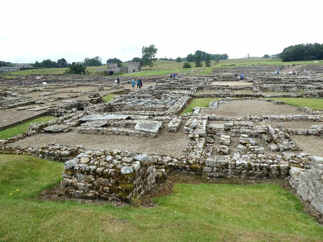
Vindolanda

Vindolanda was a Roman auxiliary fort (castrum) just south of Hadrian's Wall in northern England, which it pre-dated. Archaeological excavations of the...

Limes Britannicus

The frontier of the Roman Empire in Britain is sometimes styled Limes Britannicus ("British Limes") by authors for the boundaries, including fortifications...

Henshaw, Northumberland

Henshaw is a small village and civil parish in Northumberland, within the vicinity of the ancient Hadrian's Wall. It is located around 11.5 miles (19 km...

Nearby Amenities

Located within 500m of 54.982437,-2.3430415
Westend Town
Place: farm
Lat/Long: 54.9821104/-2.3454153
Thorngrafton
Place: hamlet
Wikidata: Q23638230
Lat/Long: 54.9829518/-2.3372986
Noexit: yes
Lat/Long: 54.9792143/-2.3462857
Noexit: yes
Lat/Long: 54.9791325/-2.3453961
Noexit: yes
Lat/Long: 54.9792117/-2.34544
Design: three-level
Power: tower
Lat/Long: 54.9833723/-2.3482487
Design: three-level
Power: tower
Lat/Long: 54.9842587/-2.3432386
Design: three-level
Power: tower
Lat/Long: 54.9851392/-2.3384012
Barrier: stile
Lat/Long: 54.9863487/-2.3402909
Barrier: stile
Bicycle: no
Foot: yes
Horse: no
Motor Vehicle: no
Lat/Long: 54.979464/-2.3420946
Barrier: stile
Bicycle: no
Foot: yes
Horse: no
Motor Vehicle: no
Lat/Long: 54.9803876/-2.3408847
Barrier: stile
Lat/Long: 54.9818157/-2.3386262
Barrier: stile
Bicycle: no
Foot: yes
Horse: no
Motor Vehicle: no
Lat/Long: 54.9811748/-2.3393245
Barrier: stile
Lat/Long: 54.9818003/-2.3387103
Barrier: stile;gate
Bicycle: private
Foot: yes
Horse: private
Motor Vehicle: private
Lat/Long: 54.9854702/-2.3453124
Barrier: stile
Lat/Long: 54.9818082/-2.3380597
Barrier: stile
Lat/Long: 54.981605/-2.3360587
Generator Method: photovoltaic
Generator Output Electricity: yes
Generator Source: solar
Generator Type: solar_photovoltaic_panel
Location: roof
Power: generator
Lat/Long: 54.9794352/-2.3474451
Generator Method: photovoltaic
Generator Output Electricity: yes
Generator Source: solar
Generator Type: solar_photovoltaic_panel
Location: roof
Power: generator
Lat/Long: 54.9794437/-2.3475242
Generator Method: photovoltaic
Generator Output Electricity: yes
Generator Source: solar
Generator Type: solar_photovoltaic_panel
Location: roof
Power: generator
Lat/Long: 54.98255/-2.3438818
Generator Method: photovoltaic
Generator Output Electricity: yes
Generator Source: solar
Generator Type: solar_photovoltaic_panel
Location: roof
Power: generator
Lat/Long: 54.9825485/-2.3439864
Barrier: stile
Material: stone
Stile: wall
Lat/Long: 54.9799153/-2.3494072
Generator Method: photovoltaic
Generator Output Electricity: yes
Generator Source: solar
Generator Type: solar_photovoltaic_panel
Location: roof
Power: generator
Lat/Long: 54.9829299/-2.3444472
Generator Method: photovoltaic
Generator Output Electricity: yes
Generator Source: solar
Generator Type: solar_photovoltaic_panel
Location: roof
Power: generator
Lat/Long: 54.9830025/-2.3418005
Barrier: stile
Foot: yes
Stile: ladder
Lat/Long: 54.9840413/-2.3449963
Barrier: stile
Stile: ladder
Lat/Long: 54.9826657/-2.3463394
Barrier: stile
Foot: yes
Lat/Long: 54.9826919/-2.3454998
The data included in this document is from www.openstreetmap.org. The data is made available under ODbL.

Have you been to West End Town?

Leave your review of West End Town below (or comments, questions and feedback).