Hawkshaw

Settlement in Lancashire

England

Hawkshaw

The Waterhouse, Sunnyhurst Hey The Waterhouse associated with the (now much depleted and disused) Sunnyhurst Hey Reservoir.
The Waterhouse, Sunnyhurst Hey Credit: Greum

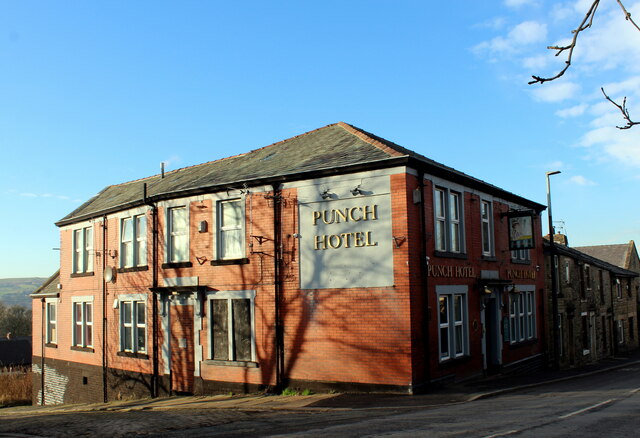
Hawkshaw is a small village located in the county of Lancashire, England. It is situated in the southern part of the region, close to the West Pennine Moors and approximately 12 miles north of the city of Manchester. The village falls under the jurisdiction of the Bury Metropolitan Borough Council.

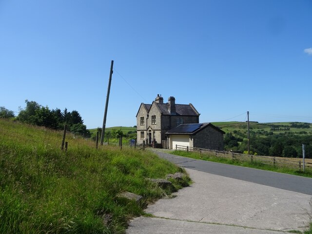
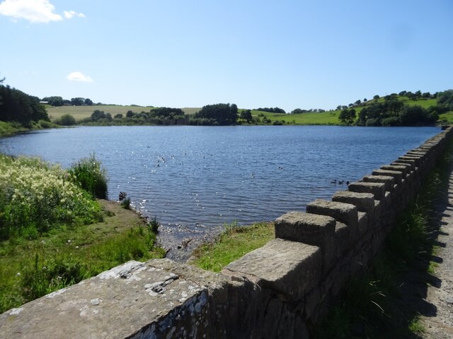
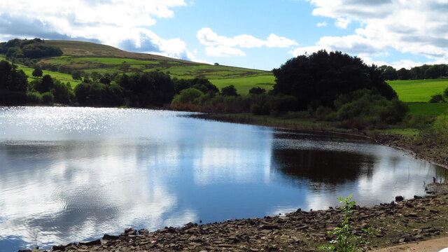
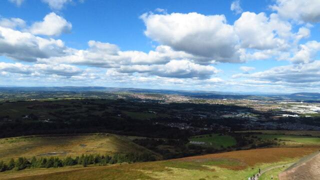
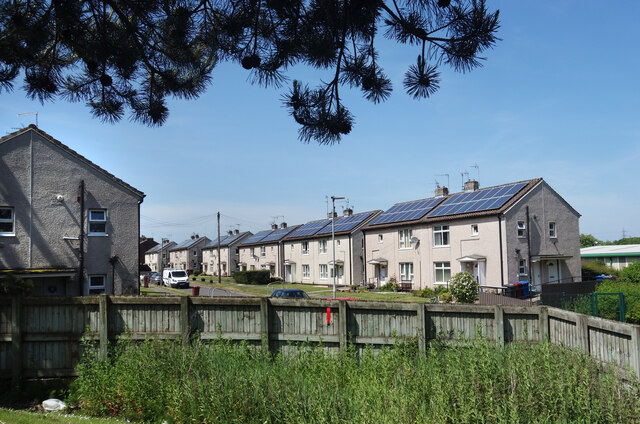
Hawkshaw is known for its picturesque setting, surrounded by rolling hills and lush green countryside. It is a predominantly rural area, with a small population of around 1,000 residents. The village is characterized by its quaint, stone-built houses and traditional architecture.

The village offers a peaceful and close-knit community atmosphere, making it an attractive place for families and individuals seeking a tranquil lifestyle. Despite its small size, Hawkshaw has a range of amenities to serve its residents, including a local primary school, post office, and a village hall that hosts various community events throughout the year.

For outdoor enthusiasts, Hawkshaw provides ample opportunities for exploring the surrounding countryside. The nearby West Pennine Moors offer stunning walking and hiking trails, while the village's proximity to the larger towns of Bury and Bolton ensures that residents have easy access to a wider range of amenities, including shopping centers, leisure facilities, and transportation links.

In summary, Hawkshaw is a charming village in Lancashire, offering a peaceful and idyllic setting amidst the beautiful English countryside. Its close-knit community, range of amenities, and proximity to larger towns make it an appealing place to call home.

If you have any feedback on the listing, please let us know in the comments section below.

Hawkshaw Images

Images are sourced within 2km of 53.707517/-2.4829508 or Grid Reference SD6823. Thanks to Geograph Open Source API. All images are credited.

The Waterhouse, Sunnyhurst Hey The Waterhouse associated with the (now much depleted and disused) Sunnyhurst Hey Reservoir.
The Waterhouse, Sunnyhurst Hey
The Waterhouse associated with the (now much depleted and disused) Sunnyhurst Hey Reservoir.
Earnsdale Reservoir
Earnsdale Reservoir
Olive Lane, Darwen Residential thoroughfare in the old Lancashire town of Darwen
Olive Lane, Darwen
Residential thoroughfare in the old Lancashire town of Darwen
Darwen Station This is Platform 1 on Darwen Station.
Currently on the Clitheroe or Ribble Valley Line, which runs services from Manchester through Blackburn, terminating in Clitheroe
Darwen Station
This is Platform 1 on Darwen Station. Currently on the Clitheroe or Ribble Valley Line, which runs services from Manchester through Blackburn, terminating in Clitheroe
Back Alley behind Sarah Street, Darwen A rather untidy back alley running north from Kay Street in Darwen
Back Alley behind Sarah Street, Darwen
A rather untidy back alley running north from Kay Street in Darwen
Kay Street, Darwen Residential street in the old Lancashire town of Darwen
Kay Street, Darwen
Residential street in the old Lancashire town of Darwen
Punch Hotel, Darwen Located at 25, Chapels - in Darwen
Punch Hotel, Darwen
Located at 25, Chapels - in Darwen
Moor Lane leading into Knowle Lane, Darwen
Holden Fold, Darwen
Holden Fold, Darwen
Old Boundary Marker on Earnsdale Reservoir dam Parish Boundary Marker on the south side of the road against the parapet of the dam of Earnsdale Reservoir. On the boundary of Tockholes and Darwen parishes. Darwen parish was created in 1894 from Lower Darwen, Over Darwen and part of Eccleshill parishes. See also <a title="https://www.geograph.org.uk/photo/408845" href="https://www.geograph.org.uk/photo/408845">Link</a>.

Milestone Society National ID: LA_TOCDAR01pb
Old Boundary Marker on Earnsdale Reservoir dam
Parish Boundary Marker on the south side of the road against the parapet of the dam of Earnsdale Reservoir. On the boundary of Tockholes and Darwen parishes. Darwen parish was created in 1894 from Lower Darwen, Over Darwen and part of Eccleshill parishes. See also Link. Milestone Society National ID: LA_TOCDAR01pb
Earnsdale Reservoir, Tockholes
Greenway Shelter, Sunnyhurst Wood, Darwen
Spitfire Memorial in Darwen
At Jubilee Tower, Darwen Hill - view N Note that Sunnyhurst Hey Reservoir shown on maps has been drained and is disused.
At Jubilee Tower, Darwen Hill - view N
Note that Sunnyhurst Hey Reservoir shown on maps has been drained and is disused.
Darwen Spitfire Memorial Sculpture The Darwen Spitfire Memorial Sculpture between Green Street and Borough Road in the centre of Darwen, as seen from the terrace of Essence Mediterranean Restaurant & Bar.
Darwen Spitfire Memorial Sculpture
The Darwen Spitfire Memorial Sculpture between Green Street and Borough Road in the centre of Darwen, as seen from the terrace of Essence Mediterranean Restaurant & Bar.
Dreaming Big at McDonald's Dreaming's free, I guess you can do it anywhere. 
A picture at Blackburn  & Darwen Services on the M65.
Dreaming Big at McDonald's
Dreaming's free, I guess you can do it anywhere. A picture at Blackburn & Darwen Services on the M65.
Redvers Road, Darwen Solar power on all the houses along here.
Redvers Road, Darwen
Solar power on all the houses along here.
Trucks at the Services Another picture taken during a leg stretch around Blackburn & Darwen Services after a long drive.
Trucks at the Services
Another picture taken during a leg stretch around Blackburn & Darwen Services after a long drive.
Show me another place!

Hawkshaw is located at Grid Ref: SD6823 (Lat: 53.707517, Lng: -2.4829508)

Unitary Authority: Blackburn with Darwen

Police Authority: Lancashire

What 3 Words

///remedy.misty.hotel. Near Darwen, Lancashire

Related Wikis

Earcroft

Earcroft is the northern ward in the town of Darwen, Lancashire, England. It borders Blackburn on the A666. It has a mix of residential, manufacturing...

St Cuthbert's Church, Darwen

St Cuthbert's Church is an Anglican church in the English market town of Darwen, Lancashire. It is an active parish church in the Diocese of Blackburn...

Darwen F.C.

Darwen Football Club is a football club from Darwen, Lancashire, England. The club was formed in 2009 as A.F.C. Darwen, a successor to the original Darwen...

Barley Bank

Barley Bank was a cricket and football ground in Darwen in England. It was the home ground of Darwen F.C. during their time in the Football League. �...

Nearby Amenities

Located within 500m of 53.707517,-2.4829508
Bus Stop
Public Transport: platform
Lat/Long: 53.7102097/-2.4812176
Bus Stop
Public Transport: platform
Lat/Long: 53.709723/-2.4812494
Place Of Worship
Hollins Grove Congregational Church
Religion: christian
Lat/Long: 53.7069581/-2.4796709
Mini Roundabout
Lat/Long: 53.7114623/-2.4816851
Place Of Worship
Roman Catholic Church of the Sacred Heart
Denomination: roman_catholic
Node Id: 975349377
Religion: christian
Source: OS_OpenData_StreetView
Source Name: OS Open Local Important Buildings Layer
Lat/Long: 53.710602/-2.4822445
Pub
Anchor Hotel
Addr City: Darwen
Addr Postcode: BB3 0AB
Addr Street: Blackburn Road
Fhrs Id: 211156
Name En: Anchor
Source Addr: FHRS Open Data
Lat/Long: 53.7100627/-2.4810094
Generator Method: photovoltaic
Generator Output Electricity: yes
Generator Source: solar
Generator Type: solar_photovoltaic_panel
Location: roof
Power: generator
Lat/Long: 53.7115216/-2.4801221
Generator Method: photovoltaic
Generator Output Electricity: yes
Generator Source: solar
Generator Type: solar_photovoltaic_panel
Location: roof
Power: generator
Lat/Long: 53.7115486/-2.4798298
Generator Method: photovoltaic
Generator Output Electricity: yes
Generator Source: solar
Generator Type: solar_photovoltaic_panel
Location: roof
Power: generator
Lat/Long: 53.7098008/-2.4854544
Generator Method: photovoltaic
Generator Output Electricity: yes
Generator Source: solar
Generator Type: solar_photovoltaic_panel
Location: roof
Power: generator
Lat/Long: 53.7092531/-2.4855992
Generator Method: photovoltaic
Generator Output Electricity: yes
Generator Source: solar
Generator Type: solar_photovoltaic_panel
Location: roof
Power: generator
Lat/Long: 53.7092229/-2.4857279
Generator Method: photovoltaic
Generator Output Electricity: yes
Generator Source: solar
Generator Type: solar_photovoltaic_panel
Location: roof
Power: generator
Lat/Long: 53.7082926/-2.4860391
Generator Method: photovoltaic
Generator Output Electricity: yes
Generator Source: solar
Generator Type: solar_photovoltaic_panel
Location: roof
Power: generator
Lat/Long: 53.7082624/-2.4866318
Generator Method: photovoltaic
Generator Output Electricity: yes
Generator Source: solar
Generator Type: solar_photovoltaic_panel
Location: roof
Power: generator
Lat/Long: 53.7080306/-2.4857789
Generator Method: photovoltaic
Generator Output Electricity: yes
Generator Source: solar
Generator Type: solar_photovoltaic_panel
Location: roof
Power: generator
Lat/Long: 53.7079782/-2.4857306
Generator Method: photovoltaic
Generator Output Electricity: yes
Generator Source: solar
Generator Type: solar_photovoltaic_panel
Location: roof
Power: generator
Lat/Long: 53.7079068/-2.4856555
Generator Method: photovoltaic
Generator Output Electricity: yes
Generator Source: solar
Generator Type: solar_photovoltaic_panel
Location: roof
Power: generator
Lat/Long: 53.7075147/-2.4860739
Generator Method: photovoltaic
Generator Output Electricity: yes
Generator Source: solar
Generator Type: solar_photovoltaic_panel
Location: roof
Power: generator
Lat/Long: 53.7074893/-2.4862215
Generator Method: photovoltaic
Generator Output Electricity: yes
Generator Source: solar
Generator Type: solar_photovoltaic_panel
Location: roof
Power: generator
Lat/Long: 53.7073591/-2.4851727
Generator Method: photovoltaic
Generator Output Electricity: yes
Generator Source: solar
Generator Type: solar_photovoltaic_panel
Location: roof
Power: generator
Lat/Long: 53.7065208/-2.4862
Generator Method: photovoltaic
Generator Output Electricity: yes
Generator Source: solar
Generator Type: solar_photovoltaic_panel
Location: roof
Power: generator
Lat/Long: 53.7065033/-2.486259
Generator Method: photovoltaic
Generator Output Electricity: yes
Generator Source: solar
Generator Type: solar_photovoltaic_panel
Location: roof
Power: generator
Lat/Long: 53.7058032/-2.4863046
Generator Method: photovoltaic
Generator Output Electricity: yes
Generator Source: solar
Generator Type: solar_photovoltaic_panel
Location: roof
Power: generator
Lat/Long: 53.7069542/-2.4873587
Generator Method: photovoltaic
Generator Output Electricity: yes
Generator Source: solar
Generator Type: solar_photovoltaic_panel
Location: roof
Power: generator
Lat/Long: 53.7070654/-2.4872112
Generator Method: photovoltaic
Generator Output Electricity: yes
Generator Source: solar
Generator Type: solar_photovoltaic_panel
Location: roof
Power: generator
Lat/Long: 53.7070717/-2.4871307
Generator Method: photovoltaic
Generator Output Electricity: yes
Generator Source: solar
Generator Type: solar_photovoltaic_panel
Location: roof
Power: generator
Lat/Long: 53.7071035/-2.4877906
Generator Method: photovoltaic
Generator Output Electricity: yes
Generator Source: solar
Generator Type: solar_photovoltaic_panel
Location: roof
Power: generator
Lat/Long: 53.7071162/-2.4879086
Generator Method: photovoltaic
Generator Output Electricity: yes
Generator Source: solar
Generator Type: solar_photovoltaic_panel
Location: roof
Power: generator
Lat/Long: 53.7072273/-2.4876377
Turning Loop
Lat/Long: 53.7060555/-2.4814716
Crossing
Crossing: zebra
Crossing Island: no
Tactile Paving: yes
Lat/Long: 53.7113304/-2.4828648
Barrier: yes
Foot: yes
Lat/Long: 53.706291/-2.4767555
Telephone
Booth: KX100
Covered: booth
Lat/Long: 53.7060133/-2.478103
Generator Method: photovoltaic
Generator Output Electricity: yes
Generator Source: solar
Generator Type: solar_photovoltaic_panel
Location: roof
Power: generator
Lat/Long: 53.7119734/-2.4820974
Generator Method: photovoltaic
Generator Output Electricity: yes
Generator Source: solar
Generator Type: solar_photovoltaic_panel
Location: roof
Power: generator
Lat/Long: 53.7119781/-2.4820156
Leisure: playground
Lat/Long: 53.7112717/-2.4794193
Leisure: playground
Lat/Long: 53.7112551/-2.4796942
Traffic Signals
Traffic Signals: crossing
Lat/Long: 53.705747/-2.4780644
Traffic Signals
Traffic Signals: signal
Lat/Long: 53.7059009/-2.4780729
Traffic Signals
Traffic Signals: signal
Traffic Signals Direction: backward
Lat/Long: 53.7057012/-2.4776841
Crossing
Crossing: traffic_signals
Crossing Island: yes
Crossing Ref: puffin
Tactile Paving: yes
Lat/Long: 53.7058583/-2.478033
Crossing
Crossing: traffic_signals
Crossing Island: yes
Crossing Ref: puffin
Tactile Paving: yes
Lat/Long: 53.7057857/-2.4780963
Traffic Signals
Traffic Signals: signal
Traffic Signals Direction: forward
Lat/Long: 53.7053758/-2.4776939
Crossing
Crossing: uncontrolled
Crossing Island: yes
Tactile Paving: yes
Lat/Long: 53.7054055/-2.4777162
Traffic Signals
Traffic Signals: signal
Traffic Signals Direction: forward
Lat/Long: 53.705444/-2.477979
The data included in this document is from www.openstreetmap.org. The data is made available under ODbL.

Have you been to Hawkshaw?

Leave your review of Hawkshaw below (or comments, questions and feedback).