Gariannonvm Roman Fort and site of Celtic Manastery

Settlement in Suffolk Great Yarmouth

England

Gariannonvm Roman Fort and site of Celtic Manastery

Burgh Castle South Eastern Tower A Saxon Shore Roman Fort <span class="nowrap"><a title="https://historicengland.org.uk/listing/the-list/list-entry/1013094?section=official-listing" rel="nofollow ugc noopener" href="https://historicengland.org.uk/listing/the-list/list-entry/1013094?section=official-listing">Link</a><img style="margin-left:2px;" alt="External link" title="External link - shift click to open in new window" src="https://s1.geograph.org.uk/img/external.png" width="10" height="10"/></span>
Burgh Castle South Eastern Tower Credit: Sandy Gerrard

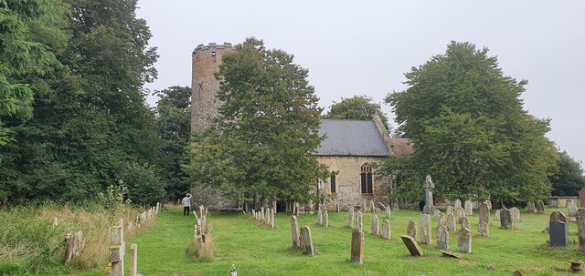
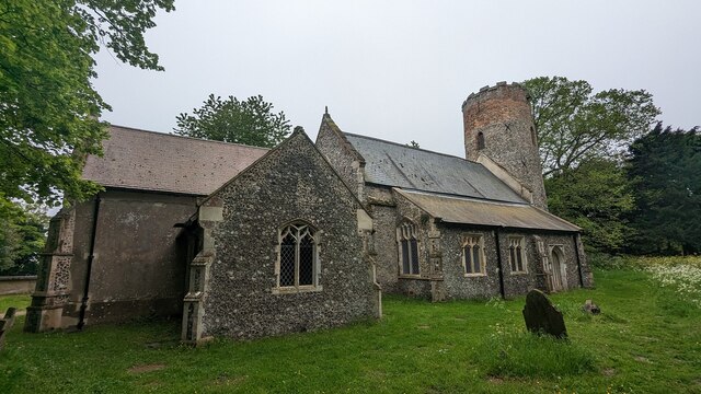
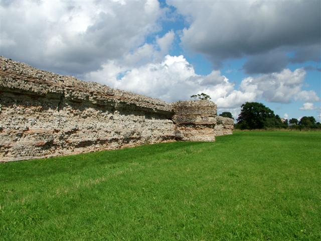
Gariannonvm Roman Fort and site of Celtic Monastery, located in Suffolk, England, is an ancient archaeological site of historical significance. The site is believed to have been occupied during two distinct periods in history, first as a Roman fort and later as a Celtic monastery.

The Roman fort at Gariannonvm dates back to the 1st century AD when it was established as a strategic military outpost. The fort was built to defend the Roman Empire's eastern frontier and control the surrounding area. It was equipped with defensive walls, barracks, and other structures typical of Roman military installations. The fort played a crucial role in maintaining Roman control over the region until it was abandoned during the 5th century.

Following the decline of the Roman Empire, the site was later occupied by a Celtic monastery. The exact timeline and details of this period are less well-documented, but archaeological evidence suggests that the site was repurposed for religious use. The Celtic monastery likely served as a center for spiritual and intellectual activities, with monks living in simple cells and engaging in prayer, meditation, and scholarly pursuits.

Today, Gariannonvm Roman Fort and site of Celtic Monastery is a popular destination for history enthusiasts and archaeology buffs. Visitors can explore the remains of the fort's defensive walls, gateways, and other structures, providing a glimpse into the military strategies and daily life during the Roman occupation. The site also offers insights into the role of religion and spirituality in the region during the Celtic monastery period.

If you have any feedback on the listing, please let us know in the comments section below.

Gariannonvm Roman Fort and site of Celtic Manastery Images

Images are sourced within 2km of 52.58712/1.6596758 or Grid Reference TG4705. Thanks to Geograph Open Source API. All images are credited.

Burgh Castle South Eastern Tower A Saxon Shore Roman Fort <span class="nowrap"><a title="https://historicengland.org.uk/listing/the-list/list-entry/1013094?section=official-listing" rel="nofollow ugc noopener" href="https://historicengland.org.uk/listing/the-list/list-entry/1013094?section=official-listing">Link</a><img style="margin-left:2px;" alt="External link" title="External link - shift click to open in new window" src="https://s1.geograph.org.uk/img/external.png" width="10" height="10"/></span>
Burgh Castle South Eastern Tower
A Saxon Shore Roman Fort LinkExternal link
Eastern Wall of Burgh Castle Saxon Shore Fort <span class="nowrap"><a title="https://historicengland.org.uk/listing/the-list/list-entry/1013094?section=official-listing" rel="nofollow ugc noopener" href="https://historicengland.org.uk/listing/the-list/list-entry/1013094?section=official-listing">Link</a><img style="margin-left:2px;" alt="External link" title="External link - shift click to open in new window" src="https://s1.geograph.org.uk/img/external.png" width="10" height="10"/></span>
Eastern Wall of Burgh Castle Saxon Shore Fort
Berney Arms Railway Station
Berney Arms Windmill
River Yare
River Yare
Train passing the cows
Wherryman's Way
Wherryman's Way
Angles Way by night View of River Waveney and boatyard near to Burgh Castle, by night.

In case anyone wonders, the bright light on right is a night-light on a post providing electric hookups for boats at the moorings.

Angles Way runs alongside the river here.
Angles Way by night
View of River Waveney and boatyard near to Burgh Castle, by night. In case anyone wonders, the bright light on right is a night-light on a post providing electric hookups for boats at the moorings. Angles Way runs alongside the river here.
Burgh Castle WW1 War Memorial
Burgh Castle WW2 War Memorial
St Peter and St Paul's church
Burgh Castle Roman Fort Burgh Castle is the site of one of nine Roman Saxon Shore forts constructed in England around the 3rd century AD. This fort was possibly known as Gariannonum.

The fort is roughly rectangular, measuring (internally) approximately 205 m (673 ft) by 100 m (330 ft). The walls on the north, east, and much of the south side are largely intact, standing at a height of approximately 4.6 m (15 ft) and measuring up to 3 m (9.8 ft) thick at the base. They have a core of mortared flint rubble and an external and internal facing of prepared flint and red tile or brick in alternating bands. Against the outer face of the walls there are six solid bastions of pear-shaped plan spaced symmetrically, two on the south wall, one each at the north-east and south-east angles, one slipped from position on the north wall, and one below the south wall where it has fallen. The west wall has at some time in the distant past collapsed down the underlying hillside and into what was once an estuary but is now a marsh, and nothing of it is now visible. Breydon Water is all that is left of the estuary this fort once overlooked. 

<span class="nowrap"><a title="https://en.wikipedia.org/wiki/Gariannonum" rel="nofollow ugc noopener" href="https://en.wikipedia.org/wiki/Gariannonum">Link</a><img style="margin-left:2px;" alt="External link" title="External link - shift click to open in new window" src="https://s1.geograph.org.uk/img/external.png" width="10" height="10"/></span>
Burgh Castle Roman Fort
Burgh Castle is the site of one of nine Roman Saxon Shore forts constructed in England around the 3rd century AD. This fort was possibly known as Gariannonum. The fort is roughly rectangular, measuring (internally) approximately 205 m (673 ft) by 100 m (330 ft). The walls on the north, east, and much of the south side are largely intact, standing at a height of approximately 4.6 m (15 ft) and measuring up to 3 m (9.8 ft) thick at the base. They have a core of mortared flint rubble and an external and internal facing of prepared flint and red tile or brick in alternating bands. Against the outer face of the walls there are six solid bastions of pear-shaped plan spaced symmetrically, two on the south wall, one each at the north-east and south-east angles, one slipped from position on the north wall, and one below the south wall where it has fallen. The west wall has at some time in the distant past collapsed down the underlying hillside and into what was once an estuary but is now a marsh, and nothing of it is now visible. Breydon Water is all that is left of the estuary this fort once overlooked. LinkExternal link
St. Peter & St. Paul's Church, Burgh Castle Grade II Listed 

Parish church. Late C11 west tower. Nave and chancel retain C13 character but remodelled C15. North aisle 1847. South porch 1857. Quaternary and Quarry flint and chert with Lincolnshire Limestone ashlar dressings and some brick.

The ruins of the neighbouring Roman fort of Gariannonum, built about 270AD, have provided much of the materials (flints and Roman tiles) to build this tower and church.
St. Peter & St. Paul's Church, Burgh Castle
Grade II Listed Parish church. Late C11 west tower. Nave and chancel retain C13 character but remodelled C15. North aisle 1847. South porch 1857. Quaternary and Quarry flint and chert with Lincolnshire Limestone ashlar dressings and some brick. The ruins of the neighbouring Roman fort of Gariannonum, built about 270AD, have provided much of the materials (flints and Roman tiles) to build this tower and church.
Footpath along the River Yare towards Breydon Water The footpath here forms part of the Angles Way.
Although late in the year, there were many dragonflies out on the wing: one can be seen in the centre of the image.
Footpath along the River Yare towards Breydon Water
The footpath here forms part of the Angles Way. Although late in the year, there were many dragonflies out on the wing: one can be seen in the centre of the image.
Burgh Flats from the Angles Way On the horizon, the two windmills are actually on the banks not of the adjacent body of water (the River Waveney) but on the River Yare, separated from the Waveney by a slim triangle of land; the two rivers meet just off to the right of the photograph.  The mills are Berney Arms Mill (to the right, still with its sails) and Red Mill (to left, without sails).
Burgh Flats from the Angles Way
On the horizon, the two windmills are actually on the banks not of the adjacent body of water (the River Waveney) but on the River Yare, separated from the Waveney by a slim triangle of land; the two rivers meet just off to the right of the photograph. The mills are Berney Arms Mill (to the right, still with its sails) and Red Mill (to left, without sails).
Breydon Water Pump and outlet
Breydon Water saltmarsh and mudflat Looking towards Lockgate Drainage Mill.
Breydon Water saltmarsh and mudflat
Looking towards Lockgate Drainage Mill.
Church of St. Peter and St. Paul, Burgh Castle <span class="nowrap"><a title="https://historicengland.org.uk/listing/the-list/list-entry/1051008?section=official-list-entry" rel="nofollow ugc noopener" href="https://historicengland.org.uk/listing/the-list/list-entry/1051008?section=official-list-entry">Link</a><img style="margin-left:2px;" alt="External link" title="External link - shift click to open in new window" src="https://s1.geograph.org.uk/img/external.png" width="10" height="10"/></span>
Church of St. Peter and St. Paul, Burgh Castle
Show me another place!

Gariannonvm Roman Fort and site of Celtic Manastery is located at Grid Ref: TG4705 (Lat: 52.58712, Lng: 1.6596758)

Administrative County: Norfolk

District: Great Yarmouth

Police Authority: Norfolk

What 3 Words

///informer.highs.shaky. Near Bradwell, Norfolk

Related Wikis

Burgh Castle

Burgh Castle is a village and civil parish in the English county of Norfolk. It is situated on the east bank of the River Waveney, some 3.7 miles (6.0...

Burgh Castle (Roman fortification)

Burgh Castle is the site of one of nine Roman Saxon Shore forts constructed in England around the 3rd century AD, to hold troops as a defence against Saxon...

Gariannonum

Gariannonum, or Gariannum, was a Roman Saxon Shore fort in Norfolk, England. The Notitia Dignitatum, a Roman Army "order of battle" from about AD 400,...

River Waveney

The River Waveney is a river which forms the boundary between Suffolk and Norfolk, England, for much of its length within The Broads. The "ey" part of...

Nearby Amenities

Located within 500m of 52.58712,1.6596758
Source: Landsat photo
Lat/Long: 52.5868454/1.6525925
Burgh Castle
Place: village
Wikidata: Q2098453
Wikipedia: en:Burgh Castle
Lat/Long: 52.5857037/1.6619305
Queens Head, adj
Naptan AtcoCode: 2900B712
Naptan Bearing: E
Naptan BusStopType: CUS
Naptan CommonName: Queens Head
Naptan Indicator: adj
Naptan Landmark: Market Road
Naptan Locality: Burgh Castle
Naptan NaptanCode: nfoagwmj
Naptan PlusbusZoneRef: YARMTH
Naptan Street: Back Lane
Naptan Verified: no
Source: naptan_import
Lat/Long: 52.5873005/1.6613167
Crossing
Crossing Markings: yes
Tactile Paving: no
Lat/Long: 52.5859338/1.6590771
Entrance: main
Lat/Long: 52.5860395/1.6542752
Bicycle Parking
Bicycle Parking: stands
Capacity: 10
Covered: no
Lat/Long: 52.586124/1.6577606
Post Box
Brand: Royal Mail
Brand Wikidata: Q638098
Brand Wikipedia: en:Royal Mail
Collection Times: Mo-Fr 09:00; Sa 07:00
Operator: Royal Mail
Operator Type: private
Operator Wikidata: Q638098
Post Box Type: lamp
Ref: NR31 3154
Royal Cypher: EIIR
Royal Cypher Wikidata: Q33102113
Lat/Long: 52.5872696/1.6609926
The data included in this document is from www.openstreetmap.org. The data is made available under ODbL.

Have you been to Gariannonvm Roman Fort and site of Celtic Manastery?

Leave your review of Gariannonvm Roman Fort and site of Celtic Manastery below (or comments, questions and feedback).