Bullers o' Buchan

Settlement in Aberdeenshire

Scotland

Bullers o' Buchan

Guillemot Nap Time Guillemots taking a nap on the sheer cliffs of the Bullers of Buchan in Aberdeenshire.
Guillemot Nap Time Credit: Iain Smith

Bullers o' Buchan is a natural wonder located in Aberdeenshire, Scotland. Situated just north of the village of Cruden Bay, it is a breathtaking geological formation that has captivated visitors for centuries.

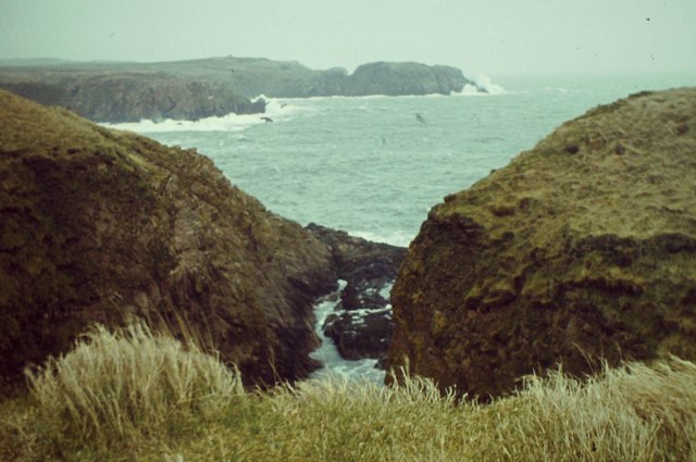
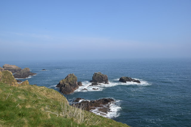
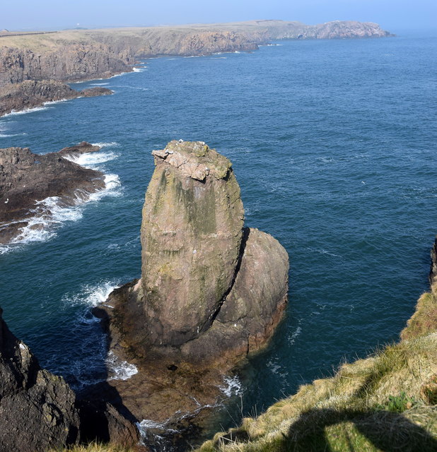
The Bullers o' Buchan is an impressive collapsed sea cave that forms a circular chasm in the coastal cliffs. The name "Bullers" is derived from the Scottish word for "boilers" because the sea surges through the narrow entrance of the cave, creating a boiling effect during rough weather. The cliffs surrounding the chasm reach up to 200 feet in height, providing a dramatic backdrop to the awe-inspiring sight.

The collapsed cave has formed a natural amphitheater, with sheer cliffs enclosing a circular depression that is now a grassy hollow. This unique feature provides a nesting ground for numerous seabirds, including puffins, guillemots, and kittiwakes. Birdwatchers flock to Bullers o' Buchan to observe the diverse avian species that inhabit the area.

Access to Bullers o' Buchan is possible via a short walk from the nearby village of Cruden Bay. Visitors can enjoy stunning views of the North Sea and the rugged coastline while exploring the cliffs and observing the birdlife. The area is also a popular spot for rock climbing enthusiasts, who are drawn to the challenging cliffs and the opportunity to scale the rugged terrain.

Bullers o' Buchan is a natural gem in Aberdeenshire, offering a unique blend of geological marvels, breathtaking views, and a haven for birdlife. It is a must-visit destination for nature enthusiasts and those seeking to connect with the raw beauty of Scotland's coastal landscape.

If you have any feedback on the listing, please let us know in the comments section below.

Bullers o' Buchan Images

Images are sourced within 2km of 57.432811/-1.823327 or Grid Reference NK1038. Thanks to Geograph Open Source API. All images are credited.

Guillemot Nap Time Guillemots taking a nap on the sheer cliffs of the Bullers of Buchan in Aberdeenshire.
Guillemot Nap Time
Guillemots taking a nap on the sheer cliffs of the Bullers of Buchan in Aberdeenshire.
Long Haven Deep and extensive geo to the north of New Slains Castle.
Long Haven
Deep and extensive geo to the north of New Slains Castle.
The Pot Looking into The Pot, a collapsed sea cave at the Bullers of Buchan. The North Sea is visible through the arch.
<span class="nowrap"><a title="http://bullersofbuchan.me.uk/" rel="nofollow ugc noopener" href="http://bullersofbuchan.me.uk/">Link</a><img style="margin-left:2px;" alt="External link" title="External link - shift click to open in new window" src="https://s1.geograph.org.uk/img/external.png" width="10" height="10"/></span>
The Pot
Looking into The Pot, a collapsed sea cave at the Bullers of Buchan. The North Sea is visible through the arch. LinkExternal link
Bullers o' Buchan Famous collapsed sea cave on the Buchan coast south of Peterhead.
<span class="nowrap"><a title="http://bullersofbuchan.me.uk/" rel="nofollow ugc noopener" href="http://bullersofbuchan.me.uk/">Link</a><img style="margin-left:2px;" alt="External link" title="External link - shift click to open in new window" src="https://s1.geograph.org.uk/img/external.png" width="10" height="10"/></span>
Bullers o' Buchan
Famous collapsed sea cave on the Buchan coast south of Peterhead. LinkExternal link
Track to Slains Castle, Cruden Bay
Puffin at the Bullers of Buchan Sadly, there seems to be less puffins this year than usual on the cliffs at the Bullers of Buchan. Possibly due to the very extreme weather whilst they were at sea this season.
Puffin at the Bullers of Buchan
Sadly, there seems to be less puffins this year than usual on the cliffs at the Bullers of Buchan. Possibly due to the very extreme weather whilst they were at sea this season.
The cliffs just south of Bullers of Buchan
At Bullers of Buchan
Bullers of Buchan
Bullers of Buchan
An overbridge and the track bed formation of the Buchan Railway above North Haven
Natural arch at Bullers of Buchan
Bullers of Buchan
Bullers of Buchan
Mussel Craig
Mussel Craig
Cairn-na-hilt
Cairn-na-hilt
Bullers of Buchan Erosion of the cliff into a sea arch.
Bullers of Buchan
Erosion of the cliff into a sea arch.
Old Railway Embankment An embankment and single bridge stanchion, remaining from the former Great North of Scotland Railway as the line headed north.
Old Railway Embankment
An embankment and single bridge stanchion, remaining from the former Great North of Scotland Railway as the line headed north.
Coastal rocks View from the cliffs beside Slains Castle: I think these are called 'The Busks'.
Coastal rocks
View from the cliffs beside Slains Castle: I think these are called 'The Busks'.
The Sugar Loaf A distinctive rock at the entrance to Long Haven inlet, a couple of hundred metres north of Slains Castle.
The Sugar Loaf
A distinctive rock at the entrance to Long Haven inlet, a couple of hundred metres north of Slains Castle.
Show me another place!

Bullers o' Buchan is located at Grid Ref: NK1038 (Lat: 57.432811, Lng: -1.823327)

Unitary Authority: Aberdeenshire

Police Authority: North East

What 3 Words

///rail.powder.drummers. Near Cruden Bay, Aberdeenshire

Related Wikis

Bullers of Buchan

The name Bullers of Buchan refers both to a collapsed sea cave and to the adjacent village, situated about 6 miles (9.7 km) south of Peterhead in Buchan...

Bullers O'Buchan Platform railway station

Bullers O'Buchan Platform railway station also known as Bullers O'Buchan Halt railway station was a railway station serving visitors to the Bullers of...

New Slains Castle

Slains Castle, also known as New Slains Castle to distinguish it from the nearby Old Slains Castle, is a ruined castle in Aberdeenshire, Scotland. It overlooks...

Longhaven railway station

Longhaven railway station was a railway station in Longhaven, Aberdeen, serving passengers and goods on the line to Boddam. It opened with the branch in...

Nearby Amenities

Located within 500m of 57.432811,-1.823327
Source: Old Landsat image trace
Lat/Long: 57.4357393/-1.8187524
Source: Old Landsat image trace
Lat/Long: 57.4347477/-1.8183904
Source: Old Landsat image trace
Lat/Long: 57.43437/-1.8175793
Source: Old Landsat image trace
Lat/Long: 57.4332065/-1.8177626
Source: Old Landsat image trace
Lat/Long: 57.4329948/-1.8176493
Source: Old Landsat image trace
Lat/Long: 57.4323636/-1.8196849
Source: Old Landsat image trace
Lat/Long: 57.4323028/-1.8165759
Source: Old Landsat image trace
Lat/Long: 57.4319255/-1.8163133
Source: Old Landsat image trace
Lat/Long: 57.4319999/-1.8184956
Source: Old Landsat image trace
Lat/Long: 57.4312386/-1.8156892
Parking
Lat/Long: 57.4325036/-1.8234811
Bullers of Buchan
Tourism: attraction
Wikidata: Q4996778
Wikipedia: en:Bullers of Buchan
Lat/Long: 57.4326056/-1.8199295
North Haven
Natural: bay
Lat/Long: 57.4351569/-1.8191812
Bullers of Buchan
Place: hamlet
Wikidata: Q4996778
Wikipedia: en:Bullers of Buchan
Lat/Long: 57.432723/-1.8217534
Blockie Head Fort
Alt Name: Old Danish Fort
Description: Three or four ditches are identified as belong to this fort.
Historic: fort
Note: location is NK 1104 3826
Ref Canmore: 75948
Source: Canmore
Wikidata: Q31084142
Lat/Long: 57.4345019/-1.8177706
Bullers of Buchan
Natural: bay
Lat/Long: 57.4327784/-1.8176482
Rabie's Haven
Natural: bay
Lat/Long: 57.43171/-1.8170045
Power: pole
Lat/Long: 57.4292717/-1.8274365
Power: pole
Lat/Long: 57.4298994/-1.8266612
Power: pole
Lat/Long: 57.4303929/-1.8260002
Power: pole
Lat/Long: 57.4310116/-1.825464
Power: pole
Lat/Long: 57.4316348/-1.8248986
Power: pole
Lat/Long: 57.4322345/-1.8244704
Power: pole
Lat/Long: 57.4330681/-1.8241649
Power: pole
Lat/Long: 57.4339061/-1.8238178
Power: pole
Lat/Long: 57.4344666/-1.8238282
Power: pole
Lat/Long: 57.4351088/-1.8238053
Power: pole
Lat/Long: 57.4358226/-1.82377
Power: pole
Lat/Long: 57.4365039/-1.8237658
Power: pole
Lat/Long: 57.4372098/-1.823743
Power: pole
Lat/Long: 57.4356872/-1.8250379
Power: pole
Lat/Long: 57.4355865/-1.8259296
Power: pole
Lat/Long: 57.4354802/-1.826815
Power: pole
Lat/Long: 57.4354746/-1.8278169
Power: pole
Lat/Long: 57.4354914/-1.828879
Power: pole
Lat/Long: 57.435488/-1.8297374
Bus Stop
Bullers of Buchan
Bus: yes
Naptan AtcoCode: 630063143
Naptan Bearing: S
Naptan BusStopType: CUS
Naptan CommonName: Bullers of Buchan
Naptan Indicator: at
Naptan NaptanCode: 23632543
Naptan Street: A975
Naptan Verified: no
Public Transport: platform
Source: naptan;bing;naptan_compare_tool
Lat/Long: 57.4327172/-1.8239573
Bus Stop
Bullers of Buchan
Bus: yes
Naptan AtcoCode: 630020121
Naptan Bearing: N
Naptan CommonName: Bullers of Buchan
Naptan Indicator: opp
Naptan NaptanCode: 23627487
Naptan Street: A975
Naptan Verified: no
Public Transport: platform
Source: naptan;bing;naptan_compare_tool
Lat/Long: 57.4325123/-1.8242332
Dunnythagert
Natural: bay
Lat/Long: 57.4342514/-1.8170164
The Gutter
Natural: bay
Lat/Long: 57.4323689/-1.8162932
Board Type: nature
Information: board
Tourism: information
Lat/Long: 57.4329888/-1.8198941
Bullers O'Buchan Platform
Historic Railway: station
Wikidata: Q58407102
Wikipedia: en:Bullers O'Buchan Platform railway station
Lat/Long: 57.4317672/-1.8245594
The data included in this document is from www.openstreetmap.org. The data is made available under ODbL.

Have you been to Bullers o' Buchan?

Leave your review of Bullers o' Buchan below (or comments, questions and feedback).