Pertook

Coastal Feature, Headland, Point in Aberdeenshire

Scotland

Pertook

Guillemot Nap Time Guillemots taking a nap on the sheer cliffs of the Bullers of Buchan in Aberdeenshire.
Guillemot Nap Time Credit: Iain Smith

Pertook, situated in Aberdeenshire, Scotland, is a picturesque coastal feature known for its striking headland and stunning point. This rugged and rocky promontory is located on the eastern coast of Scotland, overlooking the North Sea.

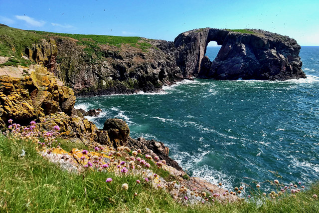
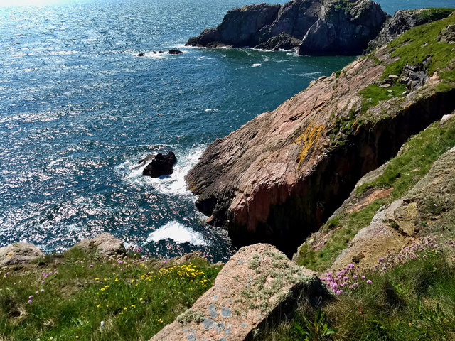
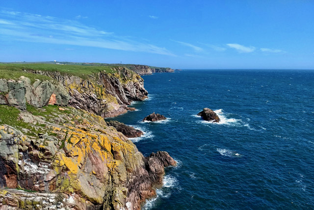
The headland of Pertook is characterized by its dramatic cliffs that rise steeply from the sea, offering breathtaking views of the surrounding landscape. The cliffs, composed of weathered granite and schist, display a rich variety of colors, ranging from deep grays to rusty reds. These cliffs not only provide an awe-inspiring backdrop but also serve as a nesting site for numerous seabirds, including kittiwakes and fulmars.

At the tip of Pertook, visitors can find a prominent point that extends into the sea, offering a unique vantage point to observe the crashing waves and the expansive horizon. The point is accessible via a well-maintained footpath, which winds along the coastline and rewards hikers with panoramic vistas.

Pertook is not only renowned for its natural beauty but also for its historical significance. The area is believed to have been inhabited since ancient times, with archaeological evidence suggesting human presence dating back thousands of years. The rugged terrain of Pertook has also played a role in maritime history, with its cliffs serving as navigational landmarks for seafarers.

With its striking headland, captivating cliffs, and historical significance, Pertook is a coastal feature that offers a memorable experience for nature enthusiasts, history buffs, and adventure seekers alike.

If you have any feedback on the listing, please let us know in the comments section below.

Pertook Images

Images are sourced within 2km of 57.434898/-1.8195028 or Grid Reference NK1038. Thanks to Geograph Open Source API. All images are credited.

Guillemot Nap Time Guillemots taking a nap on the sheer cliffs of the Bullers of Buchan in Aberdeenshire.
Guillemot Nap Time
Guillemots taking a nap on the sheer cliffs of the Bullers of Buchan in Aberdeenshire.
The Pot Looking into The Pot, a collapsed sea cave at the Bullers of Buchan. The North Sea is visible through the arch.
<span class="nowrap"><a title="http://bullersofbuchan.me.uk/" rel="nofollow ugc noopener" href="http://bullersofbuchan.me.uk/">Link</a><img style="margin-left:2px;" alt="External link" title="External link - shift click to open in new window" src="https://s1.geograph.org.uk/img/external.png" width="10" height="10"/></span>
The Pot
Looking into The Pot, a collapsed sea cave at the Bullers of Buchan. The North Sea is visible through the arch. LinkExternal link
Bullers o' Buchan Famous collapsed sea cave on the Buchan coast south of Peterhead.
<span class="nowrap"><a title="http://bullersofbuchan.me.uk/" rel="nofollow ugc noopener" href="http://bullersofbuchan.me.uk/">Link</a><img style="margin-left:2px;" alt="External link" title="External link - shift click to open in new window" src="https://s1.geograph.org.uk/img/external.png" width="10" height="10"/></span>
Bullers o' Buchan
Famous collapsed sea cave on the Buchan coast south of Peterhead. LinkExternal link
Track to Slains Castle, Cruden Bay
Puffin at the Bullers of Buchan Sadly, there seems to be less puffins this year than usual on the cliffs at the Bullers of Buchan. Possibly due to the very extreme weather whilst they were at sea this season.
Puffin at the Bullers of Buchan
Sadly, there seems to be less puffins this year than usual on the cliffs at the Bullers of Buchan. Possibly due to the very extreme weather whilst they were at sea this season.
The cliffs just south of Bullers of Buchan
At Bullers of Buchan
Bullers of Buchan
Bullers of Buchan
An overbridge and the track bed formation of the Buchan Railway above North Haven
Natural arch at Bullers of Buchan
Bullers of Buchan
Bullers of Buchan
Mussel Craig
Mussel Craig
Cairn-na-hilt
Cairn-na-hilt
Bullers of Buchan Erosion of the cliff into a sea arch.
Bullers of Buchan
Erosion of the cliff into a sea arch.
Old Railway Embankment An embankment and single bridge stanchion, remaining from the former Great North of Scotland Railway as the line headed north.
Old Railway Embankment
An embankment and single bridge stanchion, remaining from the former Great North of Scotland Railway as the line headed north.
Back of Raplin
Back of Raplin
Long Craig
Long Craig
Show me another place!

Pertook is located at Grid Ref: NK1038 (Lat: 57.434898, Lng: -1.8195028)

Unitary Authority: Aberdeenshire

Police Authority: North East

What 3 Words

///believer.that.complies. Near Cruden Bay, Aberdeenshire

Related Wikis

Bullers of Buchan

The name Bullers of Buchan refers both to a collapsed sea cave and to the adjacent village, situated about 6 miles (9.7 km) south of Peterhead in Buchan...

Bullers O'Buchan Platform railway station

Bullers O'Buchan Platform railway station also known as Bullers O'Buchan Halt railway station was a railway station serving visitors to the Bullers of...

Longhaven railway station

Longhaven railway station was a railway station in Longhaven, Aberdeen, serving passengers and goods on the line to Boddam. It opened with the branch in...

Longhaven

Longhaven is a village in Aberdeenshire, Scotland, located two miles southwest of Boddam.Longhaven railway station closed in 1948. The village had a primary...

New Slains Castle

Slains Castle, also known as New Slains Castle to distinguish it from the nearby Old Slains Castle, is a ruined castle in Aberdeenshire, Scotland. It overlooks...

A90 road

The A90 road is a major north to south road in eastern Scotland, running from Edinburgh to Fraserburgh, through Dundee and Aberdeen. Along with the A9...

RAF Buchan

Royal Air Force Buchan or more simply RAF Buchan is a former Royal Air Force station near Peterhead in Aberdeenshire, Scotland. Buchan opened in 1952 as...

RRH Buchan

Remote Radar Head Buchan or RRH Buchan is an air defence radar station operated by the Royal Air Force. It is located at Stirling Hill, 3.2 kilometres...

Nearby Amenities

Located within 500m of 57.434898,-1.8195028
Source: Old Landsat image trace
Lat/Long: 57.4370056/-1.8128479
Source: Old Landsat image trace
Lat/Long: 57.4370534/-1.8139623
Source: Old Landsat image trace
Lat/Long: 57.4379732/-1.813908
Source: Old Landsat image trace
Lat/Long: 57.4377299/-1.8143294
Source: Old Landsat image trace
Lat/Long: 57.4366457/-1.8147394
Source: Old Landsat image trace
Lat/Long: 57.4364497/-1.8166576
Source: Old Landsat image trace
Lat/Long: 57.4361586/-1.8170116
Source: Old Landsat image trace
Lat/Long: 57.4357393/-1.8187524
Source: Old Landsat image trace
Lat/Long: 57.4347477/-1.8183904
Source: Old Landsat image trace
Lat/Long: 57.43437/-1.8175793
Source: Old Landsat image trace
Lat/Long: 57.4332065/-1.8177626
Source: Old Landsat image trace
Lat/Long: 57.4329948/-1.8176493
Source: Old Landsat image trace
Lat/Long: 57.4323636/-1.8196849
Source: Old Landsat image trace
Lat/Long: 57.4323028/-1.8165759
Source: Old Landsat image trace
Lat/Long: 57.4319255/-1.8163133
Source: Old Landsat image trace
Lat/Long: 57.4319999/-1.8184956
Source: Old Landsat image trace
Lat/Long: 57.4312386/-1.8156892
Parking
Lat/Long: 57.4325036/-1.8234811
Bullers of Buchan
Tourism: attraction
Wikidata: Q4996778
Wikipedia: en:Bullers of Buchan
Lat/Long: 57.4326056/-1.8199295
North Haven
Natural: bay
Lat/Long: 57.4351569/-1.8191812
Bullers of Buchan
Place: hamlet
Wikidata: Q4996778
Wikipedia: en:Bullers of Buchan
Lat/Long: 57.432723/-1.8217534
Barrier: block
Lat/Long: 57.438249/-1.8163813
Blockie Head Fort
Alt Name: Old Danish Fort
Description: Three or four ditches are identified as belong to this fort.
Historic: fort
Note: location is NK 1104 3826
Ref Canmore: 75948
Source: Canmore
Wikidata: Q31084142
Lat/Long: 57.4345019/-1.8177706
Bullers of Buchan
Natural: bay
Lat/Long: 57.4327784/-1.8176482
Rabie's Haven
Natural: bay
Lat/Long: 57.43171/-1.8170045
Power: pole
Lat/Long: 57.4316348/-1.8248986
Power: pole
Lat/Long: 57.4322345/-1.8244704
Power: pole
Lat/Long: 57.4330681/-1.8241649
Power: pole
Lat/Long: 57.4339061/-1.8238178
Power: pole
Lat/Long: 57.4344666/-1.8238282
Power: pole
Lat/Long: 57.4351088/-1.8238053
Power: pole
Lat/Long: 57.4358226/-1.82377
Power: pole
Lat/Long: 57.4365039/-1.8237658
Power: pole
Lat/Long: 57.4372098/-1.823743
Power: pole
Lat/Long: 57.4379649/-1.8238199
Power: pole
Lat/Long: 57.4356872/-1.8250379
Power: pole
Lat/Long: 57.4355865/-1.8259296
Power: pole
Lat/Long: 57.4354802/-1.826815
Power: pole
Lat/Long: 57.4385265/-1.8184355
Power: pole
Lat/Long: 57.4385746/-1.8195641
Power: pole
Lat/Long: 57.438607/-1.820593
Power: pole
Lat/Long: 57.4386417/-1.8216904
Power: pole
Lat/Long: 57.4386943/-1.8229334
Bus Stop
Bullers of Buchan
Bus: yes
Naptan AtcoCode: 630063143
Naptan Bearing: S
Naptan BusStopType: CUS
Naptan CommonName: Bullers of Buchan
Naptan Indicator: at
Naptan NaptanCode: 23632543
Naptan Street: A975
Naptan Verified: no
Public Transport: platform
Source: naptan;bing;naptan_compare_tool
Lat/Long: 57.4327172/-1.8239573
Bus Stop
Bullers of Buchan
Bus: yes
Naptan AtcoCode: 630020121
Naptan Bearing: N
Naptan CommonName: Bullers of Buchan
Naptan Indicator: opp
Naptan NaptanCode: 23627487
Naptan Street: A975
Naptan Verified: no
Public Transport: platform
Source: naptan;bing;naptan_compare_tool
Lat/Long: 57.4325123/-1.8242332
Perdonlie
Natural: bay
Lat/Long: 57.436903/-1.8143212
Dunnythagert
Natural: bay
Lat/Long: 57.4342514/-1.8170164
The Gutter
Natural: bay
Lat/Long: 57.4323689/-1.8162932
Board Type: nature
Information: board
Tourism: information
Lat/Long: 57.4329888/-1.8198941
Bullers O'Buchan Platform
Historic Railway: station
Wikidata: Q58407102
Wikipedia: en:Bullers O'Buchan Platform railway station
Lat/Long: 57.4317672/-1.8245594
The data included in this document is from www.openstreetmap.org. The data is made available under ODbL.

Have you been to Pertook?

Leave your review of Pertook below (or comments, questions and feedback).