Vatisker
Settlement in Ross-shire
Scotland
Vatisker
Vatisker is a small village located in the county of Ross-shire, in the northern part of Scotland. Situated on the Isle of Lewis, it is part of the Outer Hebrides archipelago. Vatisker is nestled within a picturesque landscape, surrounded by rolling hills and stunning coastal views.
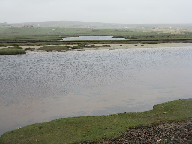
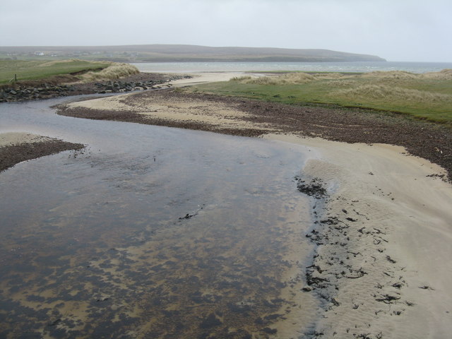
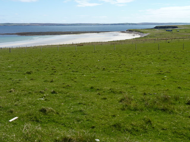
The village is known for its tranquility and natural beauty, making it a popular destination for tourists seeking a peaceful getaway. The area offers a range of outdoor activities, including hiking, birdwatching, and fishing. The nearby Vatisker Beach is a highlight, with its golden sands and crystal-clear waters.
Despite its small size, Vatisker has a strong sense of community. The villagers are friendly and welcoming, often organizing local events and festivals that showcase the area's rich cultural heritage. Traditional Scottish music and dance are often celebrated, providing visitors with an opportunity to immerse themselves in the local traditions.
In terms of amenities, Vatisker has a few small shops and cafes, providing basic necessities and a chance to sample local delicacies. For more extensive facilities, the nearby town of Stornoway offers a wider range of services, including supermarkets, restaurants, and a variety of shops.
Overall, Vatisker offers a peaceful and idyllic setting, perfect for those seeking a retreat from the busyness of modern life. Its natural beauty, welcoming community, and cultural heritage make it a destination worth exploring for any traveler venturing to the Isle of Lewis.
If you have any feedback on the listing, please let us know in the comments section below.
Vatisker Images
Images are sourced within 2km of 58.27619/-6.2990319 or Grid Reference NB4839. Thanks to Geograph Open Source API. All images are credited.
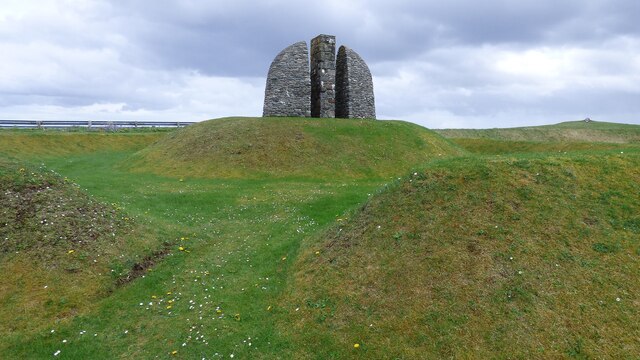
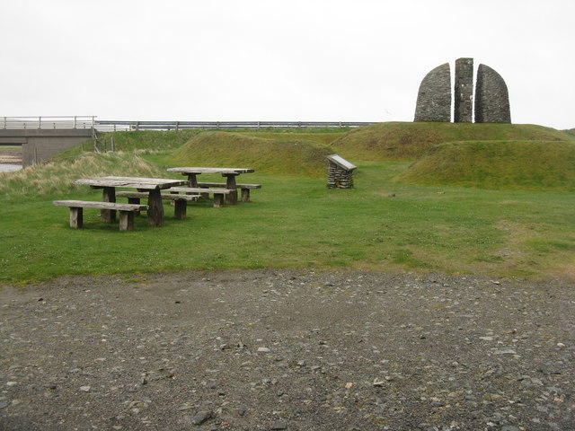
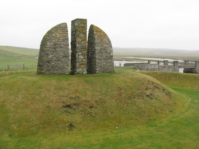
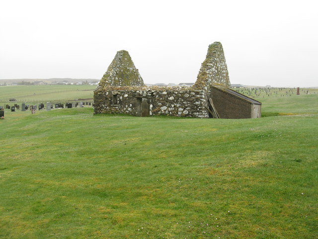
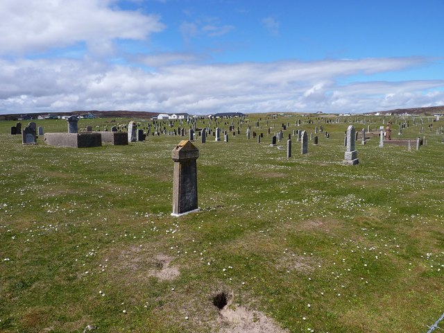
![Roadside Monument I came across three monumental and memorial cairns in a visit to Lewis and Harris, all a tribute to the people who took action to recover their homes and livelihoods in the land struggles between landlords and crofters in the 19th and early 20th centuries.
That to the Grias & Coll Raiders [NB4639], the northernmost of the three, honours the men who suffered in the Great War [1914-18] and were promised land and homes when they returned, but the promises were not honoured. The cairn is built on the site of the confrontation between the crofters of the area and Lord Leverhulme, the owner of Lewis and Harris at the time – he planned to industrialise Lewis and opposed the Board of Agriculture’s proposals to divide farms into crofts for landless families. In March 1919 some of the biggest land raids were at Upper Coll and Cress, and land raids continued throughout Lewis until 1921, when the Coll Raiders, in spite of warnings, raided and took possession of Upper Coll, a township from which their ancestors had been evicted, and distributed the land amongst their landless families. The earthworks represent the forms of trenches and waves, symbols of promises given to ex-servicemen that they would be settled on the land after the war.
The cairn at Aignish [NB4832] commemorates and symbolises the confrontation between the Aignish Raiders and the military on 9 January 1888. The raiders, men and women of Point, were driven beyond endurance by destitution and oppression. Instead of helping, the authorities used the military to try to repel the raiders. The raiders failed to hold the farm and 13 were sentenced to prison, but the episode brought their plight to a wider audience, but it was not until 1905 that the farm was divided into crofts.
At Bailailean [NB2619] the three entrances to the cairn represent the three communities that took part in the Pairc Deer Raid - Pairc, North Lochs and Kinloch. On 22 November 1887 several hundred crofters from the Pairc townships protested at their treatment by their landlords - many townships in the area had been cleared to give more access to land for deer hunting. A large number of deer were killed and a police and marines were sent to quell what was thought to be a full scale rebellion, and the Riot Act was read by the Sheriff at Ruadh Chleit [NB2908]. Six land raiders were arrested, but acquitted at the High Court in Edinburgh in January 1888.
The three monuments were designed by Will McLean in 1994-6 and built by local stonemason Jim Crawford.
Two interesting accounts of the land struggle generally, not just on Lewis and Harris, are ‘Mightier than a Lord’ by Iain Fraser Grigor [1979], Acair Limited, ISBN 0 86152 030 0, and ‘Go Listen to the Crofters’ by A.D. Cameron [1986], Acair Limited, ISBN 0 86152 063 7, although neither specifically cover the events marked by the cairns, which were a little later.
Neil MacGregor [ex-Director of the British Museum] covered the Raiders in his Radio 4 series [episode 5] <span class="nowrap"><a title="https://www.bbc.co.uk/programmes/m0015474," rel="nofollow ugc noopener" href="https://www.bbc.co.uk/programmes/m0015474,">Link</a><img style="margin-left:2px;" alt="External link" title="External link - shift click to open in new window" src="https://s1.geograph.org.uk/img/external.png" width="10" height="10"/></span> broadcast on 11 March 2022, when he visited Lews Castle Museum in Stornoway Museum nan Eilean (Stornoway) <span class="nowrap"><a title="https://www.cne-siar.gov.uk/leisure-sport-and-culture/museum-nan-eilean/museum-nan-eilean-stornoway/" rel="nofollow ugc noopener" href="https://www.cne-siar.gov.uk/leisure-sport-and-culture/museum-nan-eilean/museum-nan-eilean-stornoway/">Link</a><img style="margin-left:2px;" alt="External link" title="External link - shift click to open in new window" src="https://s1.geograph.org.uk/img/external.png" width="10" height="10"/></span>. A modern extension, opened in 2017, contains a feature on the Raiders memorial, but as yet [March 2022] we have no Geograph coverage.](https://s0.geograph.org.uk/geophotos/07/53/12/7531200_2f2d9d8f.jpg)
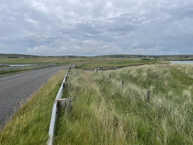
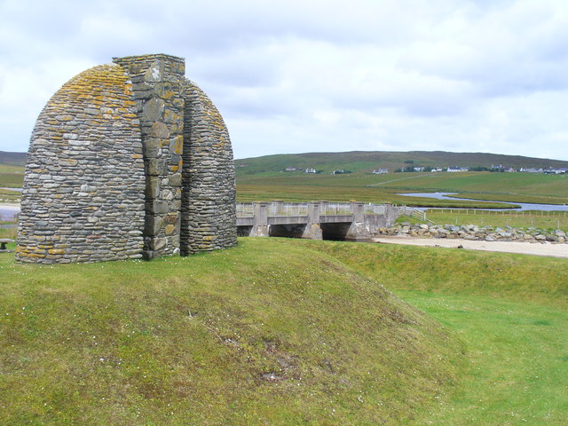
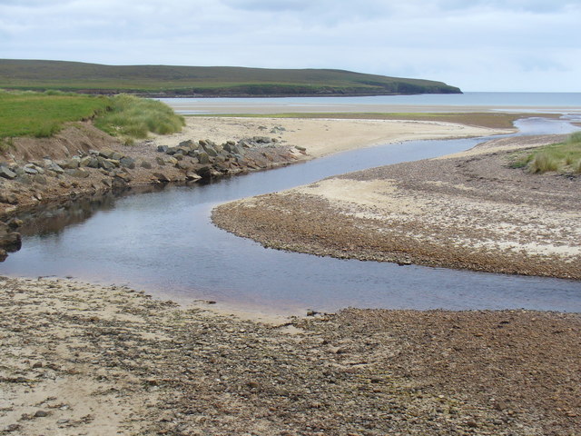
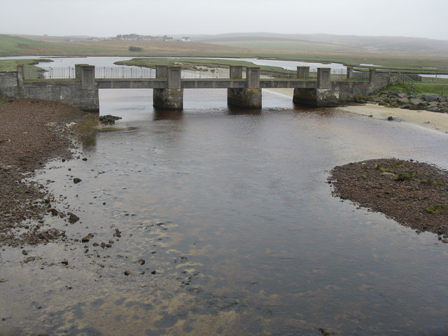
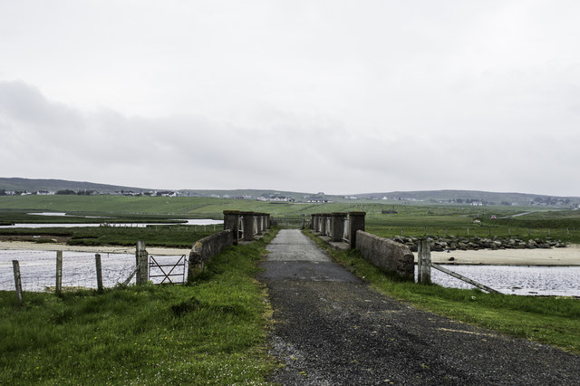
![Bridges over Abhainn Ghriais The nearest one is usable, but the road [B895] now passes across the other one, 60m to the east, just before the river flows into the sea.](https://s0.geograph.org.uk/geophotos/03/46/76/3467672_ebda50ae.jpg)
Vatisker is located at Grid Ref: NB4839 (Lat: 58.27619, Lng: -6.2990319)
Unitary Authority: Na h-Eileanan an Iar
Police Authority: Highlands and Islands
Also known as: Bhatasgeir
What 3 Words
///sector.underline.partners. Near Stornoway, Na h-Eileanan Siar
Nearby Locations
Related Wikis

Back, Lewis
Back (Scottish Gaelic: Am Bac) is a district and a village on the east coast of the Isle of Lewis in the Outer Hebrides, Scotland, situated on a coastal...

Breivig
Breivig (Scottish Gaelic: Brèibhig) is a village on Lewis in the Outer Hebrides, Scotland. Breivig is within the parish of Stornoway.According to Magne...

Coll, Lewis
Coll (Scottish Gaelic: Col) is a farming settlement near Stornoway, on the Isle of Lewis in the Outer Hebrides, Scotland. Coll is situated on the B895...

Gress
Gress (Scottish Gaelic: Griais), a hamlet on the Isle of Lewis in Scotland, is adjacent to the larger village of Back. Gress is within the parish of Stornoway...
Related Videos
![[FOUND FOOTAGE] Man In Backchurch Hears Mysterious Music #minecraft #piano #funny #magicspeet](https://i.ytimg.com/vi/mTMfXgVJJFY/hqdefault.jpg)
[FOUND FOOTAGE] Man In Backchurch Hears Mysterious Music #minecraft #piano #funny #magicspeet
Watch the full video here: https://youtu.be/6bFBAf_BD-w?si=-y7IdPwkZyuuk1Ks If the link doesn't work than just go on our channel ...

Nearby Amenities
Located within 500m of 58.27619,-6.2990319Have you been to Vatisker?
Leave your review of Vatisker below (or comments, questions and feedback).