Aydon Road Estate

Settlement in Northumberland

England

Aydon Road Estate

B6530 at East Lodge
B6530 at East Lodge Credit: Colin Pyle

Aydon Road Estate is a residential area located in Northumberland, England. Situated in the picturesque countryside, it offers a peaceful and idyllic setting for its residents. The estate is known for its well-maintained houses and beautiful gardens, which give it a charming and welcoming atmosphere.

The properties on Aydon Road Estate range from detached houses to semi-detached and terraced homes, catering to a variety of needs and preferences. Built with quality materials and modern designs, the houses boast spacious interiors and ample natural light, providing a comfortable living experience for residents.

The estate is conveniently located near local amenities, including shops, schools, and healthcare facilities, ensuring that residents have easy access to all their daily needs. There are also several parks and green spaces in the vicinity, allowing residents to enjoy outdoor activities and leisurely walks.

Furthermore, Aydon Road Estate benefits from excellent transport links, with nearby bus stops and train stations connecting it to other parts of Northumberland and beyond. The A1 road is also easily accessible, providing convenient access to Newcastle and other major cities.

Overall, Aydon Road Estate offers a desirable living environment, combining the tranquility of the countryside with the convenience of nearby amenities and transport links. It is an ideal place for families, professionals, and retirees looking for a peaceful and picturesque setting to call home.

If you have any feedback on the listing, please let us know in the comments section below.

Aydon Road Estate Images

Images are sourced within 2km of 54.976585/-2.0102965 or Grid Reference NY9964. Thanks to Geograph Open Source API. All images are credited.
B6530 at East Lodge
B6530 at East Lodge
B6530 at Howden Dene
Gallowhill Farmhouse
The Cor Burn
The Cor Burn
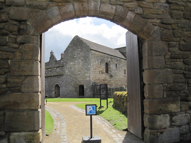
Gateway and Inner Courtyard, Aydon Castle Aydon Castle is a medieval fortified manor and one of the finest examples in England. It has various domestic, ancillary and defensive buildings arranged around three courtyards that are themselves surrounded by a curtain wall. The earliest building at Aydon was a timber-framed hall and it stood here before about 1300. Archaeologists have found remains of the timber hall in excavations. The building was replaced by a stone hall in the late 13th century and when the Scottish wars began at the beginning of the 14th century Aydon was one of the first places to be raided. This led to the manor being fortified, with battlemented walls, parapets and an outer courtyard. Inside the 'castle' was a kitchen, storerooms, service rooms, as well as the hall with it rooms for servants and the lord of the manor. Despite these attempts at defending the castle, Aydon fell to the Scots in 1315. By 1450, the owners, the de Reymes family, had let the house to tenants and it was described as ruinous. In the 16th century it transferred to the Carnaby's of Hexham and amongst the renovations and alterations they created an orchard in part of the outer courtyard. Further alterations were carried out in the following years until in the 18th and 19th centuries Aydon became a farmhouse and farm buildings were added. Most recently, the castle passed into State care in 1966 and is now managed by English Heritage. This is a Scheduled Monument and Grade I Listed Building protected by law.
<span class="nowrap"><a title="http://www.keystothepast.info/Pages/pgDetail.aspx?PRN=N9957" rel="nofollow ugc noopener" href="http://www.keystothepast.info/Pages/pgDetail.aspx?PRN=N9957">Link</a><img style="margin-left:2px;" alt="External link" title="External link - shift click to open in new window" src="https://s1.geograph.org.uk/img/external.png" width="10" height="10"/></span>
Gateway and Inner Courtyard, Aydon Castle
Aydon Castle is a medieval fortified manor and one of the finest examples in England. It has various domestic, ancillary and defensive buildings arranged around three courtyards that are themselves surrounded by a curtain wall. The earliest building at Aydon was a timber-framed hall and it stood here before about 1300. Archaeologists have found remains of the timber hall in excavations. The building was replaced by a stone hall in the late 13th century and when the Scottish wars began at the beginning of the 14th century Aydon was one of the first places to be raided. This led to the manor being fortified, with battlemented walls, parapets and an outer courtyard. Inside the 'castle' was a kitchen, storerooms, service rooms, as well as the hall with it rooms for servants and the lord of the manor. Despite these attempts at defending the castle, Aydon fell to the Scots in 1315. By 1450, the owners, the de Reymes family, had let the house to tenants and it was described as ruinous. In the 16th century it transferred to the Carnaby's of Hexham and amongst the renovations and alterations they created an orchard in part of the outer courtyard. Further alterations were carried out in the following years until in the 18th and 19th centuries Aydon became a farmhouse and farm buildings were added. Most recently, the castle passed into State care in 1966 and is now managed by English Heritage. This is a Scheduled Monument and Grade I Listed Building protected by law. LinkExternal link
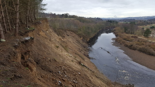
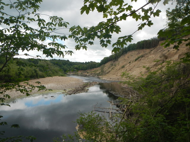
Farnley Scar This bend in the river has always suffered from erosion hence its name, however the floods in late 2015 resulted in huge erosion and land slips into the River Tyne.
Farnley Scar
This bend in the river has always suffered from erosion hence its name, however the floods in late 2015 resulted in huge erosion and land slips into the River Tyne.
Farnley Scar and River Tyne The erosion from late 2015 is evident
Farnley Scar and River Tyne
The erosion from late 2015 is evident
Road (B6321) at Piperclose Looking south-westward.
Road (B6321) at Piperclose
Looking south-westward.
Road and Bridge crossing over the A69 Looking south-westward.
Road and Bridge crossing over the A69
Looking south-westward.
Minor road joining the B6350 at Styford Toll Bar Looking southward.
Minor road joining the B6350 at Styford Toll Bar
Looking southward.
Aydon Castle Set in beautiful and secluded Northumberland woodland, Aydon Castle is just over a mile north of Corbridge.
Aydon Castle
Set in beautiful and secluded Northumberland woodland, Aydon Castle is just over a mile north of Corbridge.
Ordnance Survey Flush Bracket G2749 This bracket can be found on the wall of a house - private dwelling - at Piperclose. The benchmark height is recorded as being 95.797 metres above sea level.
For more detail see : <span class="nowrap"><a title="http://www.bench-marks.org.uk/bm14896" rel="nofollow ugc noopener" href="http://www.bench-marks.org.uk/bm14896">Link</a><img style="margin-left:2px;" alt="External link" title="External link - shift click to open in new window" src="https://s1.geograph.org.uk/img/external.png" width="10" height="10"/></span>
Ordnance Survey Flush Bracket G2749
This bracket can be found on the wall of a house - private dwelling - at Piperclose. The benchmark height is recorded as being 95.797 metres above sea level. For more detail see : LinkExternal link
Ordnance Survey Cut Mark This mark can be found on the roadside wall of Kiln House, Thornbrough. The benchmark height is recorded as being 133.56 metres above sea level.
For more detail see : <span class="nowrap"><a title="http://www.bench-marks.org.uk/bm85373" rel="nofollow ugc noopener" href="http://www.bench-marks.org.uk/bm85373">Link</a><img style="margin-left:2px;" alt="External link" title="External link - shift click to open in new window" src="https://s1.geograph.org.uk/img/external.png" width="10" height="10"/></span>
Ordnance Survey Cut Mark
This mark can be found on the roadside wall of Kiln House, Thornbrough. The benchmark height is recorded as being 133.56 metres above sea level. For more detail see : LinkExternal link
Landslip at Farnley Scar Caused by floods in December 2015 when the River Tyne reached 20 feet above its normal level. The landslip has destroyed the footpath between Corbridge and Broomhaugh.
Landslip at Farnley Scar
Caused by floods in December 2015 when the River Tyne reached 20 feet above its normal level. The landslip has destroyed the footpath between Corbridge and Broomhaugh.
Old farm buildings by Aydon Castle With an ancient sack hoist mounted on the wall.
Old farm buildings by Aydon Castle
With an ancient sack hoist mounted on the wall.
A69 passes under Aydon Road overbridge
A69 near Thornbrough
Old Milepost by the B6530, Howden Dene, Corbridge Metal post with attached metal plate by the B6530, in parish of CORBRIDGE (TYNEDALE District), Howden Dene, near Cricket Plantation, on verge at junction with lane, on North side of road. Smith Patterson iron shield, erected by the Hexham turnpike trust in the 19th century. 

Inscription reads:- : NEWCASTLE / 16 {arrow to right} / HE(XHAM / {arrow to left} 4½) : : C / 41¾ : : SMITH PATTERSON / & CO / BLAYDON :

Milestone Society National ID: NB_NCHX16.
Old Milepost by the B6530, Howden Dene, Corbridge
Metal post with attached metal plate by the B6530, in parish of CORBRIDGE (TYNEDALE District), Howden Dene, near Cricket Plantation, on verge at junction with lane, on North side of road. Smith Patterson iron shield, erected by the Hexham turnpike trust in the 19th century. Inscription reads:- : NEWCASTLE / 16 {arrow to right} / HE(XHAM / {arrow to left} 4½) : : C / 41¾ : : SMITH PATTERSON / & CO / BLAYDON : Milestone Society National ID: NB_NCHX16.
Show me another place!

Aydon Road Estate is located at Grid Ref: NY9964 (Lat: 54.976585, Lng: -2.0102965)

Unitary Authority: Northumberland

Police Authority: Northumbria

What 3 Words

///button.supplier.plod. Near Corbridge, Northumberland

Related Wikis

Corbridge

Corbridge is a village in Northumberland, England, 16 miles (26 km) west of Newcastle and 4 miles (6 km) east of Hexham. Villages nearby include Halton...

Battle of Corbridge

The Battle of Corbridge took place on the banks of the River Tyne near the village of Corbridge in Northumberland in the year 918. The battle was referenced...

Corbridge Town Hall

Corbridge Town Hall is a municipal building in Princes Street in Corbridge, Northumberland, England. The building, which is now in commercial use, is a...

Corbridge Vicar's Pele

Corbridge Vicar's Pele is a pele tower in the village of Corbridge, Northumberland, England. It was a three-storey defensive pele tower, with one room...

Nearby Amenities

Located within 500m of 54.976585,-2.0102965
Direction: both
Traffic Calming: choker
Lat/Long: 54.9733713/-2.0148094
The Fabric and Tapestry Shop
Addr City: Corbridge
Addr Housenumber: 1
Addr Postcode: NE45 5AA
Addr Street: Hill Street
Phone: +44 1434 632902
Shop: tailor
Lat/Long: 54.9750952/-2.0168109
Post Box
Ref: NE45 29
Lat/Long: 54.9788804/-2.0148928
Post Box
Ref: NE45 164
Lat/Long: 54.9786075/-2.0052224
Post Box
Collection Times: Mo-Fr 09:00; Sa 07:00
Ref: NE45 152
Royal Cypher: VR
Royal Cypher Wikidata: Q33102356
Lat/Long: 54.9758728/-2.0132903
Post Box
NE45 157D
Collection Times: Mo-Fr 09:00; Sa 07:00
Drive Through: no
Operator: Royal Mail
Operator Wikidata: Q638098
Post Box Type: wall
Ref: NE45 157D
Royal Cypher: VR
Royal Cypher Wikidata: Q33102356
Lat/Long: 54.9734613/-2.013861
Noexit: yes
Lat/Long: 54.9801434/-2.0060881
Noexit: yes
Lat/Long: 54.9754461/-2.0176084
Savilles
Office: estate_agent
Lat/Long: 54.9734776/-2.0158956
Noexit: yes
Lat/Long: 54.9791514/-2.0071641
Direction: S
Generator Method: photovoltaic
Generator Output Electricity: yes
Generator Solar Modules: 14
Generator Source: solar
Generator Type: solar_photovoltaic_panel
Location: roof
Power: generator
Lat/Long: 54.9766652/-2.0089221
Direction: S
Generator Method: photovoltaic
Generator Output Electricity: yes
Generator Solar Modules: 8
Generator Source: solar
Generator Type: solar_photovoltaic_panel
Location: roof
Power: generator
Lat/Long: 54.9737127/-2.0067294
Direction: E
Generator Method: photovoltaic
Generator Output Electricity: yes
Generator Solar Modules: 8
Generator Source: solar
Generator Type: solar_photovoltaic_panel
Location: roof
Power: generator
Lat/Long: 54.9736757/-2.0068782
Generator Method: photovoltaic
Generator Output Electricity: yes
Generator Source: solar
Generator Type: solar_photovoltaic_panel
Location: roof
Power: generator
Lat/Long: 54.9747518/-2.0105827
Generator Method: photovoltaic
Generator Output Electricity: yes
Generator Source: solar
Generator Type: solar_photovoltaic_panel
Location: roof
Power: generator
Lat/Long: 54.9751059/-2.0112292
Generator Method: photovoltaic
Generator Output Electricity: yes
Generator Source: solar
Generator Type: solar_photovoltaic_panel
Location: roof
Power: generator
Lat/Long: 54.9751105/-2.0111058
Generator Method: photovoltaic
Generator Output Electricity: yes
Generator Source: solar
Generator Type: solar_photovoltaic_panel
Location: roof
Power: generator
Lat/Long: 54.9747549/-2.0108295
Generator Method: photovoltaic
Generator Output Electricity: yes
Generator Source: solar
Generator Type: solar_photovoltaic_panel
Location: roof
Power: generator
Lat/Long: 54.974173/-2.0100785
Generator Method: photovoltaic
Generator Output Electricity: yes
Generator Source: solar
Generator Type: solar_photovoltaic_panel
Location: roof
Power: generator
Lat/Long: 54.974601/-2.0081553
Generator Method: photovoltaic
Generator Output Electricity: yes
Generator Source: solar
Generator Type: solar_photovoltaic_panel
Location: roof
Power: generator
Lat/Long: 54.9746056/-2.0082063
Generator Method: photovoltaic
Generator Output Electricity: yes
Generator Source: solar
Generator Type: solar_photovoltaic_panel
Location: roof
Power: generator
Lat/Long: 54.9763251/-2.0070691
Generator Method: photovoltaic
Generator Output Electricity: yes
Generator Source: solar
Generator Type: solar_photovoltaic_panel
Location: roof
Power: generator
Lat/Long: 54.9767053/-2.0097754
Generator Method: photovoltaic
Generator Output Electricity: yes
Generator Source: solar
Generator Type: solar_photovoltaic_panel
Location: roof
Power: generator
Lat/Long: 54.977341/-2.0083458
Generator Method: photovoltaic
Generator Output Electricity: yes
Generator Source: solar
Generator Type: solar_photovoltaic_panel
Location: roof
Power: generator
Lat/Long: 54.97744/-2.0076457
Generator Method: photovoltaic
Generator Output Electricity: yes
Generator Source: solar
Generator Type: solar_photovoltaic_panel
Location: roof
Power: generator
Lat/Long: 54.9781576/-2.007065
Generator Method: photovoltaic
Generator Output Electricity: yes
Generator Source: solar
Generator Type: solar_photovoltaic_panel
Location: roof
Power: generator
Lat/Long: 54.9753329/-2.0099565
Generator Method: photovoltaic
Generator Output Electricity: yes
Generator Source: solar
Generator Type: solar_photovoltaic_panel
Location: roof
Power: generator
Lat/Long: 54.9753329/-2.0092725
Generator Method: photovoltaic
Generator Output Electricity: yes
Generator Source: solar
Generator Type: solar_photovoltaic_panel
Location: roof
Power: generator
Lat/Long: 54.9753376/-2.0093154
Generator Method: photovoltaic
Generator Output Electricity: yes
Generator Source: solar
Generator Type: solar_photovoltaic_panel
Location: roof
Power: generator
Lat/Long: 54.9757239/-2.0118742
Generator Method: photovoltaic
Generator Output Electricity: yes
Generator Source: solar
Generator Type: solar_photovoltaic_panel
Location: roof
Power: generator
Lat/Long: 54.9773711/-2.0149024
Generator Method: photovoltaic
Generator Output Electricity: yes
Generator Source: solar
Generator Type: solar_photovoltaic_panel
Location: roof
Power: generator
Lat/Long: 54.9744478/-2.0123543
Generator Method: photovoltaic
Generator Output Electricity: yes
Generator Source: solar
Generator Type: solar_photovoltaic_panel
Location: roof
Power: generator
Lat/Long: 54.9770754/-2.0078011
Generator Method: photovoltaic
Generator Output Electricity: yes
Generator Source: solar
Generator Type: solar_photovoltaic_panel
Location: roof
Power: generator
Lat/Long: 54.9770754/-2.0077066
Generator Method: photovoltaic
Generator Output Electricity: yes
Generator Source: solar
Generator Type: solar_photovoltaic_panel
Location: roof
Power: generator
Lat/Long: 54.9758333/-2.0144995
Generator Method: photovoltaic
Generator Output Electricity: yes
Generator Source: solar
Generator Type: solar_photovoltaic_panel
Location: roof
Power: generator
Lat/Long: 54.9746979/-2.0159057
Bus Stop
Bench: no
Bus: yes
Public Transport: platform
Shelter: no
Lat/Long: 54.9734914/-2.0073965
Bus Stop
Bus: yes
Public Transport: platform
Lat/Long: 54.9734372/-2.0081345
Noexit: yes
Lat/Long: 54.9756552/-2.0176428
The data included in this document is from www.openstreetmap.org. The data is made available under ODbL.

Have you been to Aydon Road Estate?

Leave your review of Aydon Road Estate below (or comments, questions and feedback).