Rubha Beag Neidallt

Island in Ross-shire

Scotland

Rubha Beag Neidallt

Blackhouse Village at Garenin
Blackhouse Village at Garenin Credit: Colin Park

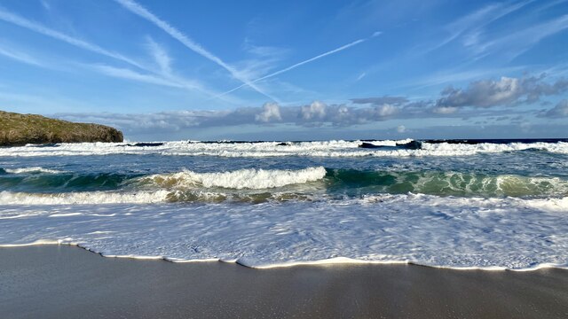
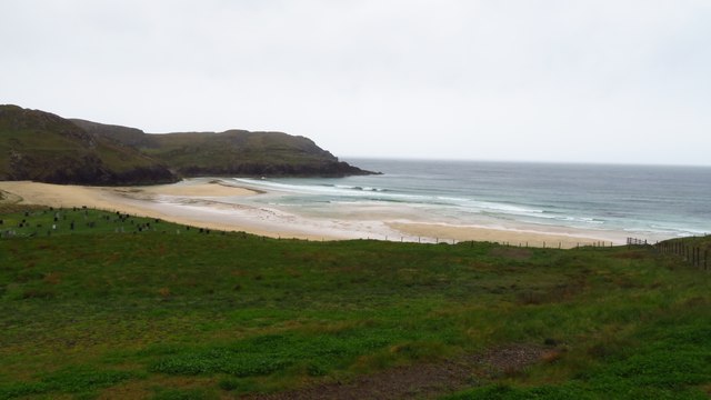
Rubha Beag Neidallt is a small uninhabited island located off the coast of Ross-shire, Scotland. Situated in the North Atlantic Ocean, it belongs to the Inner Hebrides archipelago. The island covers an area of about 2 hectares and is characterized by rugged and rocky terrain.

Rubha Beag Neidallt boasts stunning natural beauty with its picturesque landscapes and diverse wildlife. The island is home to a variety of seabirds, including puffins, guillemots, and razorbills, which nest along its cliffs. Its surrounding waters are also frequented by seals and dolphins, creating a thriving marine ecosystem.

Access to Rubha Beag Neidallt is limited due to its remote location and lack of infrastructure. Visitors can only reach the island by boat, making it a popular destination for wildlife enthusiasts, photographers, and adventurous explorers seeking solitude.

While there are no permanent human settlements on the island, its historical significance cannot be overlooked. Archaeological remains, such as ancient burial cairns and stone structures, suggest that it was inhabited in the past, possibly by early Celtic communities.

Rubha Beag Neidallt is designated as a protected area, ensuring the preservation of its natural and cultural heritage. Its untouched landscapes and abundant wildlife make it a valuable ecological asset and a must-visit destination for anyone seeking a true wilderness experience in the Scottish Highlands.

If you have any feedback on the listing, please let us know in the comments section below.

Rubha Beag Neidallt Images

Images are sourced within 2km of 58.30452/-6.789835 or Grid Reference NB1945. Thanks to Geograph Open Source API. All images are credited.

Blackhouse Village at Garenin
Waves breaking at Dalmore View from the beach at Dalmore showing the headland at Rubha an Trilleachain.
Waves breaking at Dalmore
View from the beach at Dalmore showing the headland at Rubha an Trilleachain.
Bagh Dhail Mor, Dalmore
Ruin by Loch Garenin
Bus shelter near the Tweed Mill
Na Gearrannan The main road through the restored part of the old village of blackhouses. People lived in some of these houses up until 1974.
Na Gearrannan
The main road through the restored part of the old village of blackhouses. People lived in some of these houses up until 1974.
Buildings in Gearrannan Blackhouse Village
The road to Gearrannan Blackhouse Village
Loch Garenin Sea loch below the Black House Village.
Loch Garenin
Sea loch below the Black House Village.
Blackhouse Village at Garenin The village was occupied until 1974. Restored in the later years of the Century. The plaque commemorates the opening of the village as a visitor attraction by Princess Anne. Most of the black houses are let as self-catering holiday accommodation.
Blackhouse Village at Garenin
The village was occupied until 1974. Restored in the later years of the Century. The plaque commemorates the opening of the village as a visitor attraction by Princess Anne. Most of the black houses are let as self-catering holiday accommodation.
Cottage interior, Garenin Blackhouse Village
Garenin Blackhouses Museum Group of reconstructed blackhouses which give an excellent impression of what Hebridean hamlets would have looked like 200 years ago.
Garenin Blackhouses Museum
Group of reconstructed blackhouses which give an excellent impression of what Hebridean hamlets would have looked like 200 years ago.
Garenin Blackhouses Museum A reconstructed blackhouse settlement.
Garenin Blackhouses Museum
A reconstructed blackhouse settlement.
Rubha Mor Neidallt illicit still Illicit still hidden below a large rock outcrop. <span class="nowrap"><a title="https://canmore.org.uk/site/137120/lewis-rubha-mor-neidallt" rel="nofollow ugc noopener" href="https://canmore.org.uk/site/137120/lewis-rubha-mor-neidallt">Link</a><img style="margin-left:2px;" alt="External link" title="External link - shift click to open in new window" src="https://s1.geograph.org.uk/img/external.png" width="10" height="10"/></span>
Rubha Mor Neidallt illicit still
Illicit still hidden below a large rock outcrop. LinkExternal link
Rubha Mor Neidallt illicit still View into the building from the rock outcrop above the building. <span class="nowrap"><a title="https://canmore.org.uk/site/137120/lewis-rubha-mor-neidallt" rel="nofollow ugc noopener" href="https://canmore.org.uk/site/137120/lewis-rubha-mor-neidallt">Link</a><img style="margin-left:2px;" alt="External link" title="External link - shift click to open in new window" src="https://s1.geograph.org.uk/img/external.png" width="10" height="10"/></span>
Rubha Mor Neidallt illicit still
View into the building from the rock outcrop above the building. LinkExternal link
Marker Cairn
Marker Cairn
Aird Mheadhonach cliffs, sheepfold and lazy beds
Show me another place!

Rubha Beag Neidallt is located at Grid Ref: NB1945 (Lat: 58.30452, Lng: -6.789835)

Unitary Authority: Na h-Eileanan an Iar

Police Authority: Highlands and Islands

What 3 Words

///remains.deriving.available. Near Carloway, Na h-Eileanan Siar

Related Wikis

Garenin

Garenin (Scottish Gaelic: Na Gearrannan) is a crofting township on the west coast of the Isle of Lewis in the Outer Hebrides of Scotland. Garenin is in...

Borrowston, Lewis

Borrowston (Scottish Gaelic: Borghastan), with a population of about 50, is a crofting township situated on the Isle of Lewis, on the Outer Hebrides of...

Carloway

Carloway (Scottish Gaelic: Càrlabhagh [ˈkʰaːɾɫ̪ə.ɤː]) is a crofting township and a district on the west coast of the Isle of Lewis, in the Outer Hebrides...

Siadar Wave Power Station

The Siadar Wave Power Station (also known as Siadar Wave Energy Project or SWEP) was a proposed 4 MW wave farm 400 metres (1,300 ft) off the shore of Siadar...

Nearby Amenities

Located within 500m of 58.30452,-6.789835
Created By: dmgroom_coastlines
Lat/Long: 58.30764/-6.78491
Ford: yes
Lat/Long: 58.3040672/-6.7863616
Aird Mheadhonach
Place: locality
Lat/Long: 58.3061732/-6.7828563
The data included in this document is from www.openstreetmap.org. The data is made available under ODbL.

Have you been to Rubha Beag Neidallt?

Leave your review of Rubha Beag Neidallt below (or comments, questions and feedback).