Brimstone Saltings

Coastal Marsh, Saltings in Essex Rochford

England

Brimstone Saltings

Barling Marsh Much of Barling Marsh has been given over to a landfill site and the extraction of sand and gravel. Vehicles reach the site by means of a dedicated road <a href="https://www.geograph.org.uk/gridref/TQ9288">TQ9288</a>. Taken from the berm beside Barlinghall Creek looking west.
Barling Marsh Credit: David Kemp

Brimstone Saltings is a coastal marsh located in Essex, England. It is a vast expanse of salt marshes, commonly known as saltings, situated along the eastern coast of the country. The area is renowned for its diverse ecosystem and unique landscape.

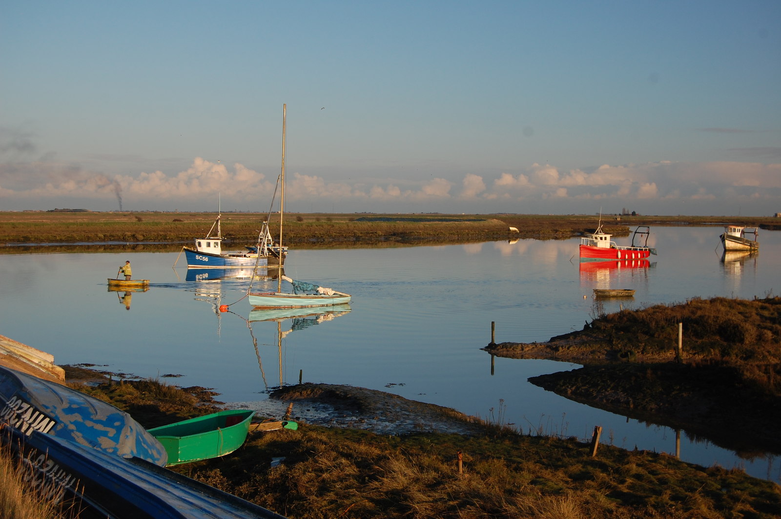
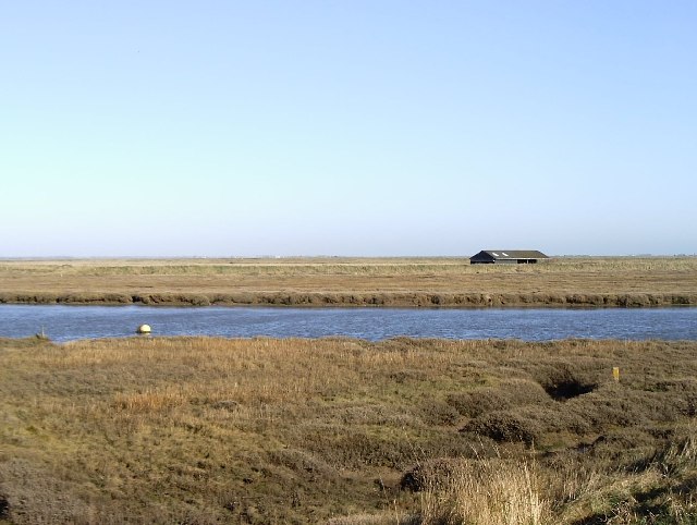
Covering a significant stretch of coastline, Brimstone Saltings is characterized by its flat and marshy terrain, with extensive mudflats and creeks that are influenced by the tidal movements of the North Sea. These tidal creeks form intricate networks, creating a habitat that supports a wide variety of plant and animal species.

The saltings provide an important feeding ground and breeding site for numerous bird species, including wading birds such as redshanks, avocets, and dunlins. These birds take advantage of the rich food sources found in the salty mudflats and shallow waters. The area is also home to a variety of rare plants, adapted to survive in the harsh saline conditions.

Brimstone Saltings is not only of ecological significance but also holds historical importance. The marshes have played a crucial role in the local economy, with traditional activities such as salt production and grazing taking place in the area for centuries.

Visitors to Brimstone Saltings can enjoy the picturesque landscape and observe the diverse wildlife. The marshes provide excellent opportunities for birdwatching, nature photography, and peaceful walks along the coastal paths. It is a place where visitors can experience the beauty of a unique coastal habitat and appreciate the delicate balance of nature.

If you have any feedback on the listing, please let us know in the comments section below.

Brimstone Saltings Images

Images are sourced within 2km of 51.569056/0.80380041 or Grid Reference TQ9489. Thanks to Geograph Open Source API. All images are credited.

Barling Marsh Much of Barling Marsh has been given over to a landfill site and the extraction of sand and gravel. Vehicles reach the site by means of a dedicated road <a href="https://www.geograph.org.uk/gridref/TQ9288">TQ9288</a>. Taken from the berm beside Barlinghall Creek looking west.
Barling Marsh
Much of Barling Marsh has been given over to a landfill site and the extraction of sand and gravel. Vehicles reach the site by means of a dedicated road TQ9288. Taken from the berm beside Barlinghall Creek looking west.
Essex Creeks The land with the farm buildings (just outside the gridsquare in <a href="https://www.geograph.org.uk/gridref/TQ9590">TQ9590</a>) on it is Potton Island to which there is no public access. The part of the mainland across the water to the right of the island is separated from it by Potton Creek. The water on the left is known as The Violet and that on the right is Barlinghall Creek.
Essex Creeks
The land with the farm buildings (just outside the gridsquare in TQ9590) on it is Potton Island to which there is no public access. The part of the mainland across the water to the right of the island is separated from it by Potton Creek. The water on the left is known as The Violet and that on the right is Barlinghall Creek.
Great Potton farm buildings, Potton Island Although Potton Island is owned by the Ministry of Defence, much of the island has been used for farming. Taken from the mainland looking north across Potton Creek.
Great Potton farm buildings, Potton Island
Although Potton Island is owned by the Ministry of Defence, much of the island has been used for farming. Taken from the mainland looking north across Potton Creek.
Drainage channel south of Barling Ness The curving drainage channel separates the large landfill site (left) from the sea wall and footpath. The water on the right is known as The Violet through which Barlinghall and Potton Creeks join the River Roach.
Drainage channel south of Barling Ness
The curving drainage channel separates the large landfill site (left) from the sea wall and footpath. The water on the right is known as The Violet through which Barlinghall and Potton Creeks join the River Roach.
The Violet The Violet is the creek through which Barlinghall Creek and Potton Creek reach the River Roach. The land beyond it is Potton Island.
The Violet
The Violet is the creek through which Barlinghall Creek and Potton Creek reach the River Roach. The land beyond it is Potton Island.
A flock of seagulls Gulls above the land-fill site on Barling Marsh
A flock of seagulls
Gulls above the land-fill site on Barling Marsh
Barling Marsh The northern edge of the landfill
Barling Marsh
The northern edge of the landfill
Oxenham's (sic) Farm Sluice This is the name given to the installation by the DoE but the farm after which it is named is referred to on OS maps and known locally as Oxenham Farm.
Oxenham's (sic) Farm Sluice
This is the name given to the installation by the DoE but the farm after which it is named is referred to on OS maps and known locally as Oxenham Farm.
Great Wakering Sea Scouts headquarters Situated below the sea-wall near Mill Head basin and overlooking Havengore Creek and Rushley Island.
Great Wakering Sea Scouts headquarters
Situated below the sea-wall near Mill Head basin and overlooking Havengore Creek and Rushley Island.
St Nicholas Church, Great Wakering
The Waeccer, Great Wakering On High Street.
See <a href="https://www.geograph.org.uk/photo/7271352">TQ9487 : Sign for the Waeccer, Great Wakering </a> for sign.
The Waeccer, Great Wakering
On High Street. See TQ9487 : Sign for the Waeccer, Great Wakering for sign.
Sign for the Waeccer, Great Wakering  See <a href="https://www.geograph.org.uk/photo/7271351">TQ9487 : The Waeccer, Great Wakering</a> for context.
Sign for the Waeccer, Great Wakering
High Street (B1017), Great Wakering
George V postbox on High Street, Great Wakering  Postbox No. SS3 8.
George V postbox on High Street, Great Wakering
Postbox No. SS3 8.
The White Hart, Great Wakering On High Street.
See <a href="https://www.geograph.org.uk/photo/7271361">TQ9487 : Sign for the White Hart, Great Wakering</a> for sign.
The White Hart, Great Wakering
On High Street. See TQ9487 : Sign for the White Hart, Great Wakering for sign.
Sign for the White Hart, Great Wakering See <a href="https://www.geograph.org.uk/photo/7271359">TQ9487 : The White Hart, Great Wakering</a> for context.
Sign for the White Hart, Great Wakering
The Memorial Hall, Great Wakering On High Street.
The Memorial Hall, Great Wakering
On High Street.
Yarn bombed Elizabeth II postbox on High Street, Great Wakering Outside the Post Office
Postbox No. SS3 179.
See <a href="https://www.geograph.org.uk/photo/7271369">TQ9487 : Post Office and shop on High Street, Great Wakering</a> for context.
Yarn bombed Elizabeth II postbox on High Street, Great Wakering
Outside the Post Office Postbox No. SS3 179. See TQ9487 : Post Office and shop on High Street, Great Wakering for context.
Show me another place!

Brimstone Saltings is located at Grid Ref: TQ9489 (Lat: 51.569056, Lng: 0.80380041)

Administrative County: Essex

District: Rochford

Police Authority: Essex

What 3 Words

///goggle.cringe.ditching. Near Great Wakering, Essex

Related Wikis

Barling, Essex

Barling is a village and former civil parish, now in the civil parish of Barling Magna in the Rochford district, in the county of Essex, England. It is...

White Ensign F.C.

White Ensign Football Club is a football club based in Southend-on-Sea, Essex, England. They are currently members of the Essex Senior League and play...

Great Wakering Rovers F.C.

Great Wakering Rovers Football Club is a football club located in Great Wakering, near Southend on Sea in Essex, England. The club are members of the Essex...

Potton Island

Potton Island is a sparsely populated island west of Foulness in Essex, England. It is connected to the mainland by a swing bridge with a traffic light...

Rushley Island

Rushley Island is a small uninhabited island in Essex, England. It is the smallest of six islands comprising an archipelago in Essex, and is privately...

Great Wakering

Great Wakering is a village in the Rochford District in Essex, England. It is approximately four miles east of Southend. Great Wakering consists mainly...

Rochford and Southend East (UK Parliament constituency)

Rochford and Southend East is a constituency represented in the House of Commons of the UK Parliament since 2005 by Sir James Duddridge, a Conservative...

HMS Beagle

HMS Beagle was a Cherokee-class 10-gun brig-sloop of the Royal Navy, one of more than 100 ships of this class. The vessel, constructed at a cost of £7...

Nearby Amenities

Located within 500m of 51.569056,0.80380041
Source: PGS
Lat/Long: 51.5724955/0.7995723
Source: PGS
Lat/Long: 51.5728822/0.8006559
Source: PGS
Lat/Long: 51.5727556/0.800849
Source: PGS
Lat/Long: 51.5726422/0.803263
Source: PGS
Lat/Long: 51.5724421/0.8035956
Source: PGS
Lat/Long: 51.5724355/0.8039496
Source: PGS
Lat/Long: 51.5726555/0.8044432
Source: PGS
Lat/Long: 51.5725088/0.8045612
Source: PGS
Lat/Long: 51.5722354/0.8039604
Source: PGS
Lat/Long: 51.5715619/0.804765
Source: PGS
Lat/Long: 51.5711618/0.8062027
Source: PGS
Lat/Long: 51.570595/0.8077691
Source: PGS
Lat/Long: 51.5700482/0.8090351
Source: PGS
Lat/Long: 51.5698014/0.8095501
Source: PGS
Lat/Long: 51.5698014/0.8100436
Created By: dmgroom_coastlines
Source: PGS
Lat/Long: 51.56951/0.809815
Created By: dmgroom_coastlines
Lat/Long: 51.566507/0.806876
Source: PGS
Lat/Long: 51.5663676/0.8041418
Created By: dmgroom_coastlines
Source: PGS
Lat/Long: 51.566694/0.803165
Created By: dmgroom_coastlines
Source: PGS
Lat/Long: 51.566943/0.802742
Created By: dmgroom_coastlines
Source: PGS
Lat/Long: 51.566927/0.80192
Created By: dmgroom_coastlines
Source: PGS
Lat/Long: 51.566912/0.801098
Created By: dmgroom_coastlines
Source: PGS
Lat/Long: 51.566633/0.799878
Created By: dmgroom_coastlines
Source: PGS
Lat/Long: 51.566625/0.799467
Created By: dmgroom_coastlines
Source: PGS
Lat/Long: 51.566482/0.798652
Source: PGS
Lat/Long: 51.5680672/0.7984547
Source: PGS
Lat/Long: 51.5689341/0.7980041
Source: PGS
Lat/Long: 51.569521/0.7988195
Source: PGS
Lat/Long: 51.5706146/0.7980041
Source: PGS
Lat/Long: 51.5710147/0.7977037
Information: route_marker
Tourism: information
Lat/Long: 51.5698538/0.8100378
The data included in this document is from www.openstreetmap.org. The data is made available under ODbL.

Have you been to Brimstone Saltings?

Leave your review of Brimstone Saltings below (or comments, questions and feedback).