Fleethead Creek

Sea, Estuary, Creek in Essex Rochford

England

Fleethead Creek

Barling Marsh Much of Barling Marsh has been given over to a landfill site and the extraction of sand and gravel. Vehicles reach the site by means of a dedicated road <a href="https://www.geograph.org.uk/gridref/TQ9288">TQ9288</a>. Taken from the berm beside Barlinghall Creek looking west.
Barling Marsh Credit: David Kemp

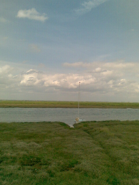
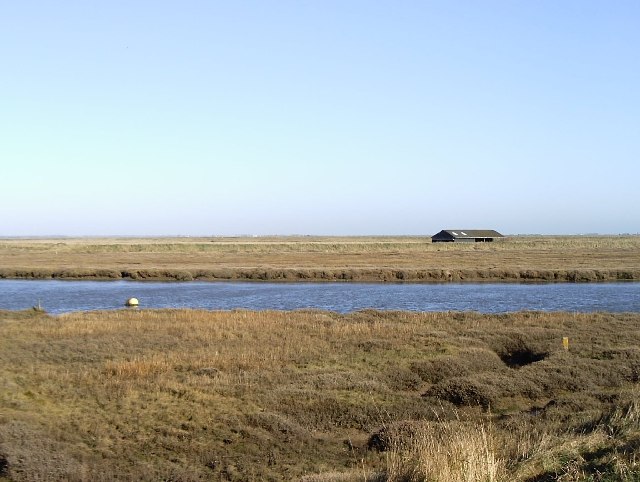
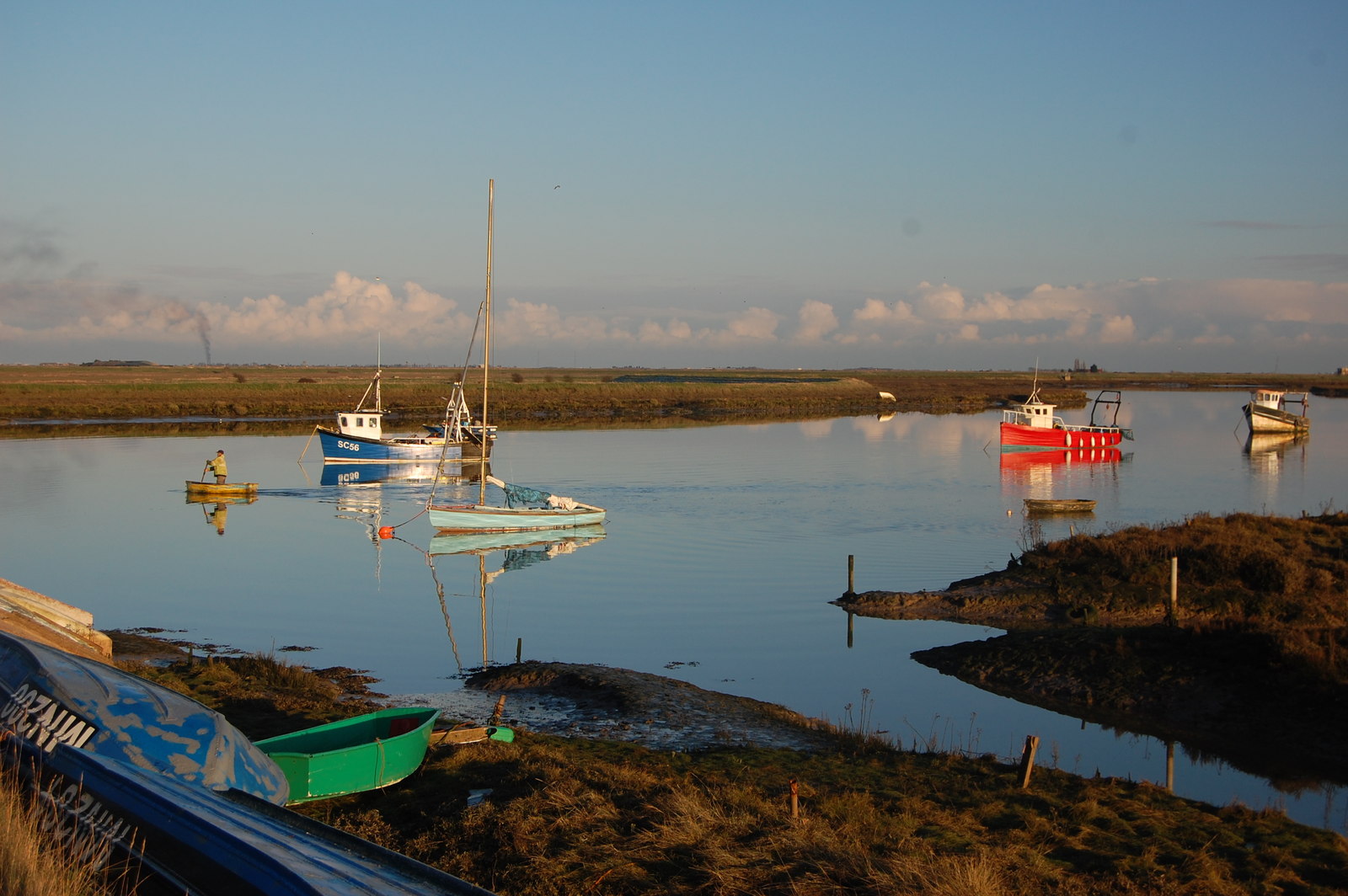
Fleethead Creek is a picturesque water body located in Essex, England. Situated along the eastern coast of the country, it is a unique combination of sea, estuary, and creek. The creek stretches approximately 6 kilometers inland from the North Sea, creating a diverse and dynamic ecosystem.

As an estuary, Fleethead Creek is influenced by the tides of the North Sea, resulting in a fluctuating water level that constantly shapes the surrounding landscape. During high tide, the creek is filled with seawater, while at low tide, the water recedes, exposing vast mudflats. This tidal influence has created a rich habitat for a variety of marine and bird species.

The creek is surrounded by beautiful marshes, mudflats, and sandbanks, which provide a haven for numerous bird species. These include wading birds such as curlews, avocets, and oystercatchers, as well as terns, gulls, and various species of duck. The mudflats are also home to an abundance of marine life, including crabs, shellfish, and worms.

Fleethead Creek is a popular destination for birdwatchers, nature enthusiasts, and photographers. The area offers several walking trails and bird hides, allowing visitors to observe and appreciate the diverse wildlife in a tranquil setting. The changing tides and seasons ensure that every visit to the creek is a unique experience.

Additionally, the creek is part of a designated nature reserve, managed by conservation organizations to protect its natural beauty and ecological importance. These efforts aim to maintain the delicate balance of the ecosystem and ensure the sustainability of the wildlife that depends on Fleethead Creek for survival.

If you have any feedback on the listing, please let us know in the comments section below.

Fleethead Creek Images

Images are sourced within 2km of 51.569844/0.80843836 or Grid Reference TQ9489. Thanks to Geograph Open Source API. All images are credited.

Barling Marsh Much of Barling Marsh has been given over to a landfill site and the extraction of sand and gravel. Vehicles reach the site by means of a dedicated road <a href="https://www.geograph.org.uk/gridref/TQ9288">TQ9288</a>. Taken from the berm beside Barlinghall Creek looking west.
Barling Marsh
Much of Barling Marsh has been given over to a landfill site and the extraction of sand and gravel. Vehicles reach the site by means of a dedicated road TQ9288. Taken from the berm beside Barlinghall Creek looking west.
Essex Creeks The land with the farm buildings (just outside the gridsquare in <a href="https://www.geograph.org.uk/gridref/TQ9590">TQ9590</a>) on it is Potton Island to which there is no public access. The part of the mainland across the water to the right of the island is separated from it by Potton Creek. The water on the left is known as The Violet and that on the right is Barlinghall Creek.
Essex Creeks
The land with the farm buildings (just outside the gridsquare in TQ9590) on it is Potton Island to which there is no public access. The part of the mainland across the water to the right of the island is separated from it by Potton Creek. The water on the left is known as The Violet and that on the right is Barlinghall Creek.
Great Potton farm buildings, Potton Island Although Potton Island is owned by the Ministry of Defence, much of the island has been used for farming. Taken from the mainland looking north across Potton Creek.
Great Potton farm buildings, Potton Island
Although Potton Island is owned by the Ministry of Defence, much of the island has been used for farming. Taken from the mainland looking north across Potton Creek.
Drainage channel south of Barling Ness The curving drainage channel separates the large landfill site (left) from the sea wall and footpath. The water on the right is known as The Violet through which Barlinghall and Potton Creeks join the River Roach.
Drainage channel south of Barling Ness
The curving drainage channel separates the large landfill site (left) from the sea wall and footpath. The water on the right is known as The Violet through which Barlinghall and Potton Creeks join the River Roach.
The Violet The Violet is the creek through which Barlinghall Creek and Potton Creek reach the River Roach. The land beyond it is Potton Island.
The Violet
The Violet is the creek through which Barlinghall Creek and Potton Creek reach the River Roach. The land beyond it is Potton Island.
A flock of seagulls Gulls above the land-fill site on Barling Marsh
A flock of seagulls
Gulls above the land-fill site on Barling Marsh
Barling Marsh The northern edge of the landfill
Barling Marsh
The northern edge of the landfill
From east shore of Rushley Island across Narrow Cuts towards Havengore Island View east across the saltgrass marshes from near the eastern sea wall of Rushley Island, overlooking the channel known as Narrow Cuts with the western side of Havengore Island in the background.
From east shore of Rushley Island across Narrow Cuts towards Havengore Island
View east across the saltgrass marshes from near the eastern sea wall of Rushley Island, overlooking the channel known as Narrow Cuts with the western side of Havengore Island in the background.
Oxenham's (sic) Farm Sluice This is the name given to the installation by the DoE but the farm after which it is named is referred to on OS maps and known locally as Oxenham Farm.
Oxenham's (sic) Farm Sluice
This is the name given to the installation by the DoE but the farm after which it is named is referred to on OS maps and known locally as Oxenham Farm.
Great Wakering Sea Scouts headquarters Situated below the sea-wall near Mill Head basin and overlooking Havengore Creek and Rushley Island.
Great Wakering Sea Scouts headquarters
Situated below the sea-wall near Mill Head basin and overlooking Havengore Creek and Rushley Island.
St Nicholas Church, Great Wakering
The Waeccer, Great Wakering On High Street.
See <a href="https://www.geograph.org.uk/photo/7271352">TQ9487 : Sign for the Waeccer, Great Wakering </a> for sign.
The Waeccer, Great Wakering
On High Street. See TQ9487 : Sign for the Waeccer, Great Wakering for sign.
Sign for the Waeccer, Great Wakering  See <a href="https://www.geograph.org.uk/photo/7271351">TQ9487 : The Waeccer, Great Wakering</a> for context.
Sign for the Waeccer, Great Wakering
High Street (B1017), Great Wakering
George V postbox on High Street, Great Wakering  Postbox No. SS3 8.
George V postbox on High Street, Great Wakering
Postbox No. SS3 8.
The White Hart, Great Wakering On High Street.
See <a href="https://www.geograph.org.uk/photo/7271361">TQ9487 : Sign for the White Hart, Great Wakering</a> for sign.
The White Hart, Great Wakering
On High Street. See TQ9487 : Sign for the White Hart, Great Wakering for sign.
Sign for the White Hart, Great Wakering See <a href="https://www.geograph.org.uk/photo/7271359">TQ9487 : The White Hart, Great Wakering</a> for context.
Sign for the White Hart, Great Wakering
The Memorial Hall, Great Wakering On High Street.
The Memorial Hall, Great Wakering
On High Street.
Show me another place!

Fleethead Creek is located at Grid Ref: TQ9489 (Lat: 51.569844, Lng: 0.80843836)

Administrative County: Essex

District: Rochford

Police Authority: Essex

What 3 Words

///screening.replayed.headers. Near Great Wakering, Essex

Related Wikis

Potton Island

Potton Island is a sparsely populated island west of Foulness in Essex, England. It is connected to the mainland by a swing bridge with a traffic light...

Rushley Island

Rushley Island is a small uninhabited island in Essex, England. It is the smallest of six islands comprising an archipelago in Essex, and is privately...

Barling, Essex

Barling is a village and former civil parish, now in the civil parish of Barling Magna in the Rochford district, in the county of Essex, England. It is...

White Ensign F.C.

White Ensign Football Club is a football club based in Southend-on-Sea, Essex, England. They are currently members of the Essex Senior League and play...

Great Wakering Rovers F.C.

Great Wakering Rovers Football Club is a football club located in Great Wakering, near Southend on Sea in Essex, England. The club are members of the Essex...

Great Wakering

Great Wakering is a village in the Rochford District in Essex, England. It is approximately four miles east of Southend. Great Wakering consists mainly...

Rochford and Southend East (UK Parliament constituency)

Rochford and Southend East is a constituency represented in the House of Commons of the UK Parliament since 2005 by Sir James Duddridge, a Conservative...

New England Island

New England Island is an uninhabited island in Essex, England. One road crosses the island, connecting it with bridges to Foulness and to the mainland...

Nearby Amenities

Located within 500m of 51.569844,0.80843836
Source: PGS
Lat/Long: 51.5726422/0.803263
Source: PGS
Lat/Long: 51.5724421/0.8035956
Source: PGS
Lat/Long: 51.5724355/0.8039496
Source: PGS
Lat/Long: 51.5726555/0.8044432
Source: PGS
Lat/Long: 51.5725088/0.8045612
Source: PGS
Lat/Long: 51.5722354/0.8039604
Source: PGS
Lat/Long: 51.5715619/0.804765
Source: PGS
Lat/Long: 51.5711618/0.8062027
Source: PGS
Lat/Long: 51.570595/0.8077691
Source: PGS
Lat/Long: 51.5700482/0.8090351
Source: PGS
Lat/Long: 51.5698014/0.8095501
Source: PGS
Lat/Long: 51.5698014/0.8100436
Created By: dmgroom_coastlines
Source: PGS
Lat/Long: 51.56951/0.809815
Created By: dmgroom_coastlines
Lat/Long: 51.566507/0.806876
Source: PGS
Lat/Long: 51.5663676/0.8041418
Information: route_marker
Tourism: information
Lat/Long: 51.5698538/0.8100378
The data included in this document is from www.openstreetmap.org. The data is made available under ODbL.

Have you been to Fleethead Creek?

Leave your review of Fleethead Creek below (or comments, questions and feedback).