Gardenness Point

Coastal Marsh, Saltings in Essex Rochford

England

Gardenness Point

Old pontoons at Wallasea Marina These wooden pontoons, now beached, abandoned and decaying on the saltings, once formed part of the WW2 coastal defence booms in the wider Thames Estuary.
A few of the many hundreds originally deployed were repurposed at the end of hostilities to form a floating dock at Wallasea marina and remained in service for some years before being replaced with the current modern pontoon berths
Old pontoons at Wallasea Marina Credit: John Myers

Gardenness Point is a coastal marsh and saltings located in Essex, England. Situated on the east coast of the county, it is a significant natural landmark known for its diverse ecosystem and breathtaking scenery.

Covering an area of approximately 150 hectares, Gardenness Point is a haven for wildlife enthusiasts and nature lovers. The marshland is rich in biodiversity, providing a home to a wide range of plant and animal species. The area is characterized by its distinct saltmarsh vegetation, which thrives in the brackish water that floods the marsh with each high tide. This unique habitat supports a variety of salt-tolerant plants, including samphire, sea lavender, and sea purslane.

The marshland at Gardenness Point also attracts numerous bird species, making it a popular spot for birdwatching. Visitors can observe wading birds such as curlews, redshanks, and oystercatchers, as well as migratory birds during the winter months. Additionally, the area serves as an important breeding ground for species like avocets and little terns.

The landscape itself is characterized by vast stretches of tidal mudflats and saltmarshes, which are exposed during low tide and provide a habitat for various invertebrates and shellfish. The constantly changing intertidal zone creates a dynamic environment that is constantly evolving with the ebb and flow of the tides.

Gardenness Point is not only a site of ecological importance but also a place of great natural beauty. The marshland offers stunning panoramic views of the coastline, with the distant horizon stretching out to the North Sea. Its tranquil atmosphere and unspoiled surroundings make it a perfect destination for those seeking a peaceful and immersive experience in nature.

If you have any feedback on the listing, please let us know in the comments section below.

Gardenness Point Images

Images are sourced within 2km of 51.622401/0.80518193 or Grid Reference TQ9495. Thanks to Geograph Open Source API. All images are credited.

Old pontoons at Wallasea Marina These wooden pontoons, now beached, abandoned and decaying on the saltings, once formed part of the WW2 coastal defence booms in the wider Thames Estuary.
A few of the many hundreds originally deployed were repurposed at the end of hostilities to form a floating dock at Wallasea marina and remained in service for some years before being replaced with the current modern pontoon berths
Old pontoons at Wallasea Marina
These wooden pontoons, now beached, abandoned and decaying on the saltings, once formed part of the WW2 coastal defence booms in the wider Thames Estuary. A few of the many hundreds originally deployed were repurposed at the end of hostilities to form a floating dock at Wallasea marina and remained in service for some years before being replaced with the current modern pontoon berths
Grapnells Farm
Grapnells Farm
Anti-predator ditch and fence The ditch encloses the Marsh Flats grazing area and lagoons - a major nesting area within the reserve
Anti-predator ditch and fence
The ditch encloses the Marsh Flats grazing area and lagoons - a major nesting area within the reserve
Anti-predator ditch and fence Western perimeter of Marsh Flats
Anti-predator ditch and fence
Western perimeter of Marsh Flats
War Memorial Burnham-on-Crouch
War Memorial
Burnham-on-Crouch
Burnham Yacht Harbour Marina
Channel through the mudflats - RSPB Wallasea Island The following adapted from the RSPB website <span class="nowrap"><a title="https://www.rspb.org.uk/reserves-and-events/reserves-a-z/wallasea-island/" rel="nofollow ugc noopener" href="https://www.rspb.org.uk/reserves-and-events/reserves-a-z/wallasea-island/">Link</a><img style="margin-left:2px;" alt="External link" title="External link - shift click to open in new window" src="https://s1.geograph.org.uk/img/external.png" width="10" height="10"/></span>

"The reserve covers more than 740ha, with all of the arable farmland now transformed to saltmarsh, mudflats, lagoons and grazing marsh.

There are six walking trails – Jubilee Marsh, Allfleets Marsh, Marsh Flats, South Trail, New Pool Trail and Beagle Trail, making over 15km of trail on the reserve. At the ends of Allfleets Marsh trail and Jubilee Marsh trail are two shelters providing a comfortable place to sit overlooking the river.

To create this magical landscape of marshland, lagoons, ditches and sea, more than three million tonnes of earth was brought by boat from the tunnels and shafts created by the Crossrail scheme in London. This allowed us to raise the land above sea level and place the soil in a way that created a new 115-hectare intertidal area of saltmarsh, islands and mudflats (known as Jubilee Marsh).

In addition, Crossrail helped us create saline lagoons, a creek network and grazing marsh. All of which means Wallasea Island is now a wildlife-rich habitat and a great place to visit.

Wallasea Island sits within a Special Protection Area which covers the Crouch and Roach estuaries, and which is special for overwintering waders and wildfowl including Brent Geese. Our work here increases the habitat for these birds both whilst roosting and feeding, as well as creating new grassland areas (wet and dry). The intertidal areas have been designed with climate change in mind, with long shallow slopes from the new seawall providing space for the saltmarsh to creep up as sea levels rise."
Channel through the mudflats - RSPB Wallasea Island
The following adapted from the RSPB website LinkExternal link "The reserve covers more than 740ha, with all of the arable farmland now transformed to saltmarsh, mudflats, lagoons and grazing marsh. There are six walking trails – Jubilee Marsh, Allfleets Marsh, Marsh Flats, South Trail, New Pool Trail and Beagle Trail, making over 15km of trail on the reserve. At the ends of Allfleets Marsh trail and Jubilee Marsh trail are two shelters providing a comfortable place to sit overlooking the river. To create this magical landscape of marshland, lagoons, ditches and sea, more than three million tonnes of earth was brought by boat from the tunnels and shafts created by the Crossrail scheme in London. This allowed us to raise the land above sea level and place the soil in a way that created a new 115-hectare intertidal area of saltmarsh, islands and mudflats (known as Jubilee Marsh). In addition, Crossrail helped us create saline lagoons, a creek network and grazing marsh. All of which means Wallasea Island is now a wildlife-rich habitat and a great place to visit. Wallasea Island sits within a Special Protection Area which covers the Crouch and Roach estuaries, and which is special for overwintering waders and wildfowl including Brent Geese. Our work here increases the habitat for these birds both whilst roosting and feeding, as well as creating new grassland areas (wet and dry). The intertidal areas have been designed with climate change in mind, with long shallow slopes from the new seawall providing space for the saltmarsh to creep up as sea levels rise."
Maintenance at Clements Marsh sluice The land on the opposite side of Paglesham Pool is Wallasea Island.
Maintenance at Clements Marsh sluice
The land on the opposite side of Paglesham Pool is Wallasea Island.
Clements Marsh sluice - landward side
Church Hall sluice Taken at the point where Paglesham Pool morphs into Paglesham Creek.
Church Hall sluice
Taken at the point where Paglesham Pool morphs into Paglesham Creek.
Footbridge at Church Hall sluice Taken at the point where Paglesham Pool morphs into Paglesham Creek.
Footbridge at Church Hall sluice
Taken at the point where Paglesham Pool morphs into Paglesham Creek.
Paglesham Creek flood barrier
Burnham-on-Crouch Station Towards Southminster
Burnham-on-Crouch Station
Towards Southminster
Merit unloading at Baltic Wharf, Wallasea Island General Cargo ship Merit, in from Riga with a load of timber. View from near Burnham Marina
Merit unloading at Baltic Wharf, Wallasea Island
General Cargo ship Merit, in from Riga with a load of timber. View from near Burnham Marina
Creeksea Ferry Road The causeway onto Wallasea Island underwater near the top of a 5.4 metre spring tide. The large majority of tides do not get high enough to cover the road so this is quite a rare occurrence.
Creeksea Ferry Road
The causeway onto Wallasea Island underwater near the top of a 5.4 metre spring tide. The large majority of tides do not get high enough to cover the road so this is quite a rare occurrence.
Elm Farm Sluice
Elm Farm Sluice
Burnham-on-Crouch Sunset Looking west at the Royal Corinthian Yacht Club as the sun just dipped below the horizon. Although a cold day was coming to an end already the pubs in town were bustling as a Friday night was starting.
Burnham-on-Crouch Sunset
Looking west at the Royal Corinthian Yacht Club as the sun just dipped below the horizon. Although a cold day was coming to an end already the pubs in town were bustling as a Friday night was starting.
Creeksea Place - north frontage Creeksea Place dates from 1569 but has been extensively rebuilt and added to over the centuries. Today the main house and its ancillary buildings serve a variety of leisure and social purposes.
Creeksea Place - north frontage
Creeksea Place dates from 1569 but has been extensively rebuilt and added to over the centuries. Today the main house and its ancillary buildings serve a variety of leisure and social purposes.
Show me another place!

Gardenness Point is located at Grid Ref: TQ9495 (Lat: 51.622401, Lng: 0.80518193)

Administrative County: Essex

District: Rochford

Police Authority: Essex

What 3 Words

///rollers.registers.amending. Near Burnham-on-Crouch, Essex

Nearby Locations

Gardenness Point

Related Wikis

Burnham-on-Crouch & District Museum

The Burnham-on-Crouch and District Museum, located in Burnham-on-Crouch, Essex, is a registered charity run by members of the Burnham History Society,...

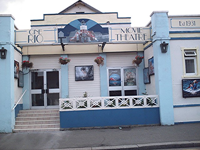
Rio Cinema (Burnham on Crouch)

The Rio Cinema is a purpose-built, two-screen, 280-seat cinema in Burnham on Crouch, Essex in the United Kingdom. The building dates from 1931. The Burnham...

Burnham-on-Crouch

Burnham-on-Crouch is a town and civil parish in the Maldon District of Essex, in the East of England; it lies on the north bank of the River Crouch. It...

Royal Corinthian Yacht Club

The Royal Corinthian Yacht Club is a watersports organisation based at Burnham-on-Crouch, Essex. == History == === Early history === The club was founded...

Nearby Amenities

Located within 500m of 51.622401,0.80518193
Source: PGS
Lat/Long: 51.6256411/0.8001681
Source: PGS
Lat/Long: 51.6257556/0.8013957
Source: PGS
Lat/Long: 51.6259736/0.8030271
Source: PGS
Lat/Long: 51.6261173/0.803094
Source: PGS
Lat/Long: 51.6262639/0.8024288
Source: PGS
Lat/Long: 51.6267456/0.8053926
Source: PGS
Lat/Long: 51.6262541/0.8047821
Source: PGS
Lat/Long: 51.6262106/0.80436
Source: PGS
Lat/Long: 51.6261108/0.8043047
Source: PGS
Lat/Long: 51.626377/0.8068796
Source: PGS
Lat/Long: 51.6261757/0.8087075
Source: PGS
Lat/Long: 51.621862/0.7989692
Source: PGS
Lat/Long: 51.621672/0.7993812
Source: PGS
Lat/Long: 51.6217421/0.8005356
Source: PGS
Lat/Long: 51.6216355/0.801115
Source: PGS
Lat/Long: 51.6220618/0.8045267
Source: PGS
Lat/Long: 51.621489/0.8105349
Source: PGS
Lat/Long: 51.620623/0.8106207
Source: PGS
Lat/Long: 51.6206097/0.8111786
Noexit: yes
Lat/Long: 51.6261492/0.8044428
Bench
Backrest: yes
Material: wood
Lat/Long: 51.6262359/0.8086496
Bench
Backrest: yes
Material: wood
Lat/Long: 51.6262594/0.8081932
Bench
Backrest: yes
Material: wood
Lat/Long: 51.6263394/0.8075139
Leisure: picnic_table
Material: wood
Lat/Long: 51.626468/0.8073929
Leisure: picnic_table
Material: wood
Lat/Long: 51.6264965/0.807209
Leisure: picnic_table
Material: wood
Lat/Long: 51.6265194/0.8070273
Leisure: picnic_table
Material: wood
Lat/Long: 51.6265565/0.8073251
Leisure: picnic_table
Material: wood
Lat/Long: 51.6265757/0.80714
Leisure: picnic_table
Material: wood
Lat/Long: 51.6266486/0.8072446
Seamark Buoy Lateral Category: starboard
Seamark Buoy Lateral Colour: green
Seamark Buoy Lateral Shape: conical
Seamark Buoy Lateral System: iala-a
Seamark Name: Burnham Fairway No.11
Seamark Type: buoy_lateral
Source: Crouch Harbour Authority;survey
Lat/Long: 51.623815/0.8051781
Seamark Buoy Special Purpose Category: leading
Seamark Buoy Special Purpose Colour: yellow
Seamark Buoy Special Purpose Shape: pillar
Seamark Name: Burnham Yacht Harbour Entrance
Seamark Type: buoy_special_purpose
Lat/Long: 51.6249967/0.8039274
Bench
Lat/Long: 51.6265598/0.8065777
Bench
Lat/Long: 51.6265706/0.8064637
Bench
Lat/Long: 51.6265931/0.8063403
Bench
Lat/Long: 51.6266131/0.8062089
Bench
Lat/Long: 51.6266298/0.8060533
Bench
Lat/Long: 51.6266597/0.8059226
Bench
Lat/Long: 51.6267155/0.80582
Seamark Beacon Lateral Category: port
Seamark Beacon Lateral Colour: red
Seamark Beacon Lateral Shape: post
Seamark Type: beacon_lateral
Lat/Long: 51.6261032/0.8034153
Seamark Beacon Lateral Category: starboard
Seamark Beacon Lateral Colour: green
Seamark Beacon Lateral Shape: post
Seamark Type: beacon_lateral
Lat/Long: 51.6261223/0.8038418
The data included in this document is from www.openstreetmap.org. The data is made available under ODbL.

Have you been to Gardenness Point?

Leave your review of Gardenness Point below (or comments, questions and feedback).