Gorsaf Porth Penrhyn

Coastal Marsh, Saltings in Merionethshire

Wales

Gorsaf Porth Penrhyn

Reclaimed land in the Mawddach estuary The Mawddach trail runs on the embankment of the former railway line from Dolgellau to Abermaw/Barmouth.  All the land north of the main road (A493) is part of the estuary and was regularly flooded until the railway and other embankments such as Mawddach Crescent <a title="https://www.geograph.org.uk/photo/171496" href="https://www.geograph.org.uk/photo/171496">Link</a> were built.  Its location sheltered from the main part of the estuary behind the former islands of Fegla Fawr <a title="https://www.geograph.org.uk/photo/391817" href="https://www.geograph.org.uk/photo/391817">Link</a> and Fegla Fach and y Ro Wen (the shingle spit across the mouth of the estuary on which Fairbourne lies) has led to the formation of a raised bog by the side of the estuary.  In the past, peat has been extracted for use beyond the immediate locality.  Nowadays, this area is a Site of Specific Scientific Interest and nature reserve.
The hills in the background are the Diffwys ridge in the southern Rhinogydd, with Diffwys itself the one on the right.
Reclaimed land in the Mawddach estuary Credit: Rudi Winter

Gorsaf Porth Penrhyn is a coastal marsh and saltings located in Merionethshire, Wales. Situated on the northern coast of the country, it is a significant natural reserve known for its diverse ecosystems and stunning scenery. Covering an area of approximately 500 hectares, Gorsaf Porth Penrhyn is a haven for wildlife and plant species.

The marshland is characterized by its unique combination of saltwater and freshwater habitats, creating a rich and varied environment. The area is influenced by the tides, resulting in a constantly changing landscape that is home to various species of birds, fish, and insects. It is particularly renowned for being a vital stopover site for migratory birds, attracting a wide range of species throughout the year.

The saltings, which are areas of land flooded by seawater, are a distinctive feature of Gorsaf Porth Penrhyn. These areas are home to specialized plants that can tolerate the high salt content in the soil. They create a vibrant habitat for various invertebrates, including snails and crabs, which in turn attract birds and other predators.

Visitors to Gorsaf Porth Penrhyn can explore the reserve through a network of well-maintained footpaths and observation points. These provide opportunities for birdwatching, wildlife photography, and peaceful walks amidst the natural beauty of the area. The reserve is also involved in conservation efforts, aiming to protect and preserve the delicate balance of its ecosystems.

In conclusion, Gorsaf Porth Penrhyn in Merionethshire is a coastal marsh and saltings that offers a unique and diverse natural environment. Its significance as a wildlife habitat and its stunning landscapes make it a must-visit destination for nature enthusiasts and those seeking tranquility in the Welsh countryside.

If you have any feedback on the listing, please let us know in the comments section below.

Gorsaf Porth Penrhyn Images

Images are sourced within 2km of 52.715205/-4.0480762 or Grid Reference SH6115. Thanks to Geograph Open Source API. All images are credited.

Reclaimed land in the Mawddach estuary The Mawddach trail runs on the embankment of the former railway line from Dolgellau to Abermaw/Barmouth.  All the land north of the main road (A493) is part of the estuary and was regularly flooded until the railway and other embankments such as Mawddach Crescent <a title="https://www.geograph.org.uk/photo/171496" href="https://www.geograph.org.uk/photo/171496">Link</a> were built.  Its location sheltered from the main part of the estuary behind the former islands of Fegla Fawr <a title="https://www.geograph.org.uk/photo/391817" href="https://www.geograph.org.uk/photo/391817">Link</a> and Fegla Fach and y Ro Wen (the shingle spit across the mouth of the estuary on which Fairbourne lies) has led to the formation of a raised bog by the side of the estuary.  In the past, peat has been extracted for use beyond the immediate locality.  Nowadays, this area is a Site of Specific Scientific Interest and nature reserve.
The hills in the background are the Diffwys ridge in the southern Rhinogydd, with Diffwys itself the one on the right.
Reclaimed land in the Mawddach estuary
The Mawddach trail runs on the embankment of the former railway line from Dolgellau to Abermaw/Barmouth. All the land north of the main road (A493) is part of the estuary and was regularly flooded until the railway and other embankments such as Mawddach Crescent Link were built. Its location sheltered from the main part of the estuary behind the former islands of Fegla Fawr Link and Fegla Fach and y Ro Wen (the shingle spit across the mouth of the estuary on which Fairbourne lies) has led to the formation of a raised bog by the side of the estuary. In the past, peat has been extracted for use beyond the immediate locality. Nowadays, this area is a Site of Specific Scientific Interest and nature reserve. The hills in the background are the Diffwys ridge in the southern Rhinogydd, with Diffwys itself the one on the right.
Children swimming in the Mawddach as sunset approaches A perfect end to a perfect day.
Children swimming in the Mawddach as sunset approaches
A perfect end to a perfect day.
Barmouth Bridge Looking along the railway-cum-pedestrian-cum-bicycle-cum-motorcycle bridge towards Braich Ddu, the mountain in the hazy distance.
Barmouth Bridge
Looking along the railway-cum-pedestrian-cum-bicycle-cum-motorcycle bridge towards Braich Ddu, the mountain in the hazy distance.
Barmouth Bridge and Braich Ddu The near part of the bridge is designed to swing to let taller vessels through, but, according to the toll-keepers, this has not happened for decades. Braich Ddu is the mountain in the right distance.
Barmouth Bridge and Braich Ddu
The near part of the bridge is designed to swing to let taller vessels through, but, according to the toll-keepers, this has not happened for decades. Braich Ddu is the mountain in the right distance.
Barmouth Bridge at sunset Taken from the eastern end of Mawddach Crescent, near Arthog.
Barmouth Bridge at sunset
Taken from the eastern end of Mawddach Crescent, near Arthog.
Barmouth Beach With a stiff breeze blowing more sandblasting than sunbathing today
Barmouth Beach
With a stiff breeze blowing more sandblasting than sunbathing today
In Barmouth Barmouth is squeezed between the sea and the mountains. An alleyway near the market is backed by cliffs.
In Barmouth
Barmouth is squeezed between the sea and the mountains. An alleyway near the market is backed by cliffs.
Harbour at Barmouth On a cold and misty May morning
Harbour at Barmouth
On a cold and misty May morning
Barmouth Bridge/Pont Abermaw This wonderful wooden structure was opened in 1867. 
If you want to walk across the bridge, the toll is currently 90p.
Barmouth Bridge/Pont Abermaw
This wonderful wooden structure was opened in 1867. If you want to walk across the bridge, the toll is currently 90p.
Train on Barmouth Bridge The train is heading towards Morfa Mawddach station, 
the bridge goes through 3 geograph squares.
Train on Barmouth Bridge
The train is heading towards Morfa Mawddach station, the bridge goes through 3 geograph squares.
Train on Barmouth Bridge The train is heading towards Morfa Mawddach station, 
the bridge goes through 3 geograph squares.
Train on Barmouth Bridge
The train is heading towards Morfa Mawddach station, the bridge goes through 3 geograph squares.
Barmouth Harbour
Barmouth Harbour
Barmouth Bridge
Barmouth Bridge
Barmouth Beach Blue sky and White sand.  Could almost be the Bahamas!  But no,  The temperature tells you it's Barmouth.
Barmouth Beach
Blue sky and White sand. Could almost be the Bahamas! But no, The temperature tells you it's Barmouth.
The Roundhouse,  Barmouth On 21st of October 1830 the civic dignitaries of Barmouth met to discuss the problem of controlling drunken brawls in the town. A town lock-up was decided upon, Completed in 1834 it continued in use until the police station opened in 1861.   They are in great need today.  Every town should have one,  or several !
  The strange structure on the grass is a surprisingly comfortable seat.  It bears the inscription "Glyndwr 1840".  I can only assume this to be the name of an old timber framed ship from which it came.  There is a similar one nearby bearing the name "Lady Vaughan 1826"  See <a href="https://www.geograph.org.uk/photo/2438349">SH6115 : Lady Vaughan 1826.</a>
The Roundhouse, Barmouth
On 21st of October 1830 the civic dignitaries of Barmouth met to discuss the problem of controlling drunken brawls in the town. A town lock-up was decided upon, Completed in 1834 it continued in use until the police station opened in 1861. They are in great need today. Every town should have one, or several ! The strange structure on the grass is a surprisingly comfortable seat. It bears the inscription "Glyndwr 1840". I can only assume this to be the name of an old timber framed ship from which it came. There is a similar one nearby bearing the name "Lady Vaughan 1826" See SH6115 : Lady Vaughan 1826.
Lady Vaughan 1826. The above title is the inscription on this seat adjacent to the Roundhouse on Barmouth's promenade.  It appears to be part of the hull of a small timber framed ship.  It is surprisingly comfortable. Given a couple of cushions, I could have been there for hours.
Lady Vaughan 1826.
The above title is the inscription on this seat adjacent to the Roundhouse on Barmouth's promenade. It appears to be part of the hull of a small timber framed ship. It is surprisingly comfortable. Given a couple of cushions, I could have been there for hours.
Easter Island ???? No, It's Barmouth.   Looking Northwest from the sand dunes at the end of the breakwater.
Easter Island ????
No, It's Barmouth. Looking Northwest from the sand dunes at the end of the breakwater.
Barmouth Beach Barmouth's promenade from the dunes at the end of the breakwater.
Barmouth Beach
Barmouth's promenade from the dunes at the end of the breakwater.
Show me another place!

Gorsaf Porth Penrhyn is located at Grid Ref: SH6115 (Lat: 52.715205, Lng: -4.0480762)

Unitary Authority: Gwynedd

Police Authority: North Wales

What 3 Words

///searcher.weekday.craters. Near Barmouth, Gwynedd

Related Wikis

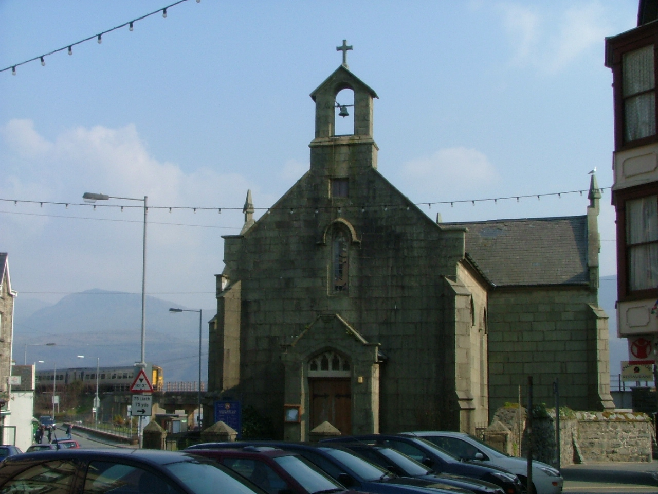
St David's Church, Barmouth

St David's Church is a Church in Wales church by the harbour of Barmouth, Gwynedd, west Wales. It is part of the Bro Ardudwy Ministry Area. == History... ==

Barmouth Bridge

Barmouth Bridge (Welsh: Pont Abermaw), or Barmouth Viaduct is a Grade II* listed single-track wooden railway viaduct across the estuary of the River Mawddach...

Fairbourne Spit

Fairbourne Spit (also known as Penrhyn Point) is a long spit of sand and shingle at the mouth of the River Mawddach where it reaches Cardigan Bay, on the...

Barmouth Lifeboat Station

Barmouth Lifeboat Station is located in Barmouth, a town at the mouth of the Afon Mawddach river in Gwynedd, Wales. A lifeboat was first stationed here...

Nearby Amenities

Located within 500m of 52.715205,-4.0480762
Source: PGS
Lat/Long: 52.7165417/-4.0526037
Source: PGS
Lat/Long: 52.716484/-4.0522461
Source: PGS
Lat/Long: 52.7165456/-4.0521507
Source: PGS
Lat/Long: 52.7166052/-4.0521692
Source: PGS
Lat/Long: 52.7166923/-4.0523242
Source: PGS
Lat/Long: 52.7174441/-4.0536229
Source: PGS
Lat/Long: 52.7177388/-4.0539086
Source: PGS
Lat/Long: 52.7185395/-4.0523874
Source: PGS
Lat/Long: 52.7187021/-4.0519122
Source: PGS
Lat/Long: 52.7189153/-4.051533
Source: PGS
Lat/Long: 52.7193085/-4.0452652
Source: PGS
Lat/Long: 52.7113655/-4.0515861
Source: PGS
Lat/Long: 52.7115989/-4.0515984
Source: PGS
Lat/Long: 52.7118692/-4.0515941
Source: PGS
Lat/Long: 52.711867/-4.0510872
Source: PGS
Lat/Long: 52.7121396/-4.0509176
Source: PGS
Lat/Long: 52.7128421/-4.051249
Source: PGS
Lat/Long: 52.713505/-4.05097
Source: PGS
Lat/Long: 52.713635/-4.0494036
Source: PGS
Lat/Long: 52.7152104/-4.0480509
Source: PGS
Lat/Long: 52.7156241/-4.0491943
Source: PGS
Lat/Long: 52.7171994/-4.0540553
Ferry Terminal
Barmouth Ferry
Ferry: yes
Note: foot passenger ferry from penrhyn to barmouth
Public Transport: station
Waterway Sign: ferry
Lat/Long: 52.7156701/-4.0485987
Cardigan Bay Dolphins
Board Type: wildlife
Check Date: 2021-09-12
Information: board
Tourism: information
Lat/Long: 52.7184637/-4.0527451
Cardigan Bay Dolphins
Board Type: wildlife
Check Date: 2021-09-12
Information: board
Tourism: information
Lat/Long: 52.7184279/-4.0526938
Cardigan Bay Dolphins
Board Type: wildlife
Information: board
Tourism: information
Lat/Long: 52.7183922/-4.0527625
Cardigan Bay Dolphins
Board Type: wildlife
Check Date: 2021-09-12
Information: board
Tourism: information
Lat/Long: 52.7184392/-4.0528165
Bench
Backrest: yes
Lat/Long: 52.71856/-4.0523972
Bench
Backrest: yes
Check Date: 2024-02-26
Lat/Long: 52.7186791/-4.0522255
Barmouth Harbour
Harbour: yes
Natural: bay
Seamark Type: harbour
Lat/Long: 52.7189451/-4.051155
Estuary Halt
Railway: station
Usage: tourism
Wikidata: Q5401889
Lat/Long: 52.7122942/-4.0518658
Railway: switch
Railway Switch Switch Blade: spring
Lat/Long: 52.714199/-4.0508323
Barmouth Ferry
Naptan AtcoCode: 940GZZFBBMF
Public Transport: station
Railway: station
Source: OS OpenData StreetView
Usage: tourism
Wikidata: Q4861278
Lat/Long: 52.7151503/-4.0485009
Ferry Terminal
Ferry: yes
Public Transport: station
Lat/Long: 52.7187148/-4.0516781
Crossing Barrier: no
Railway: level_crossing
Lat/Long: 52.7146455/-4.0488374
Crossing Barrier: no
Railway: crossing
Lat/Long: 52.7153419/-4.0487625
Cardigan Bay Dolphins
Artwork Type: statue
Tourism: artwork
Wikimedia Commons: Category:Cardigan Bay Dolphins statue in Barmouth
Lat/Long: 52.7184416/-4.0527561
Source: PGS
Lat/Long: 52.7169463/-4.0534438
Leisure: slipway
Lat/Long: 52.7184792/-4.0529711
Leisure: slipway
Lat/Long: 52.7186849/-4.0521121
Leisure: slipway
Lat/Long: 52.7188183/-4.0516416
Seamark Light Colour: red
Seamark Light Range: 5
Seamark Type: light_major
Lat/Long: 52.7165043/-4.0519941
Toilets
Fee: no
Wheelchair: yes
Lat/Long: 52.7187557/-4.0518285
Tourism: viewpoint
Lat/Long: 52.7197028/-4.0478813
Source: PGS
Lat/Long: 52.7142688/-4.0511009
Source: PGS
Lat/Long: 52.7142054/-4.0515998
Source: PGS
Lat/Long: 52.7155202/-4.0497092
Source: PGS
Lat/Long: 52.7151903/-4.050533
Source: PGS
Lat/Long: 52.7156648/-4.0496019
Source: PGS
Lat/Long: 52.715668/-4.04902
Ferry Terminal
Ferry: yes
Public Transport: station
Lat/Long: 52.7156153/-4.0487706
Leisure: slipway
Lat/Long: 52.712508/-4.0509984
Water Point
Lat/Long: 52.7186625/-4.0521783
The Lobster Pot
Shop: seafood
Lat/Long: 52.7188434/-4.0522272
Restaurant
Lobster Pot
Cuisine: fish;sandwich;ice_cream;tea;cake;coffee_shop
Name En: Lobster Pot
Lat/Long: 52.7188417/-4.052208
Bicycle Parking
Access: yes
Bicycle Parking: stands
Capacity: 6
Covered: no
Lat/Long: 52.7186712/-4.0521333
Bicycle Parking
Access: yes
Bicycle Parking: stands
Capacity: 6
Covered: no
Lat/Long: 52.7186917/-4.0520668
Crossing Barrier: no
Railway: crossing
Lat/Long: 52.7153707/-4.0487501
Railway: level_crossing
Lat/Long: 52.7123948/-4.0518267
The data included in this document is from www.openstreetmap.org. The data is made available under ODbL.

Have you been to Gorsaf Porth Penrhyn?

Leave your review of Gorsaf Porth Penrhyn below (or comments, questions and feedback).