Dumpton Point

Coastal Feature, Headland, Point in Kent Thanet

England

Dumpton Point

Below East Cliff, Broadstairs This whole bay and the wave-cut platform are all submerged at high tide.
Below East Cliff, Broadstairs Credit: Trevor Harris

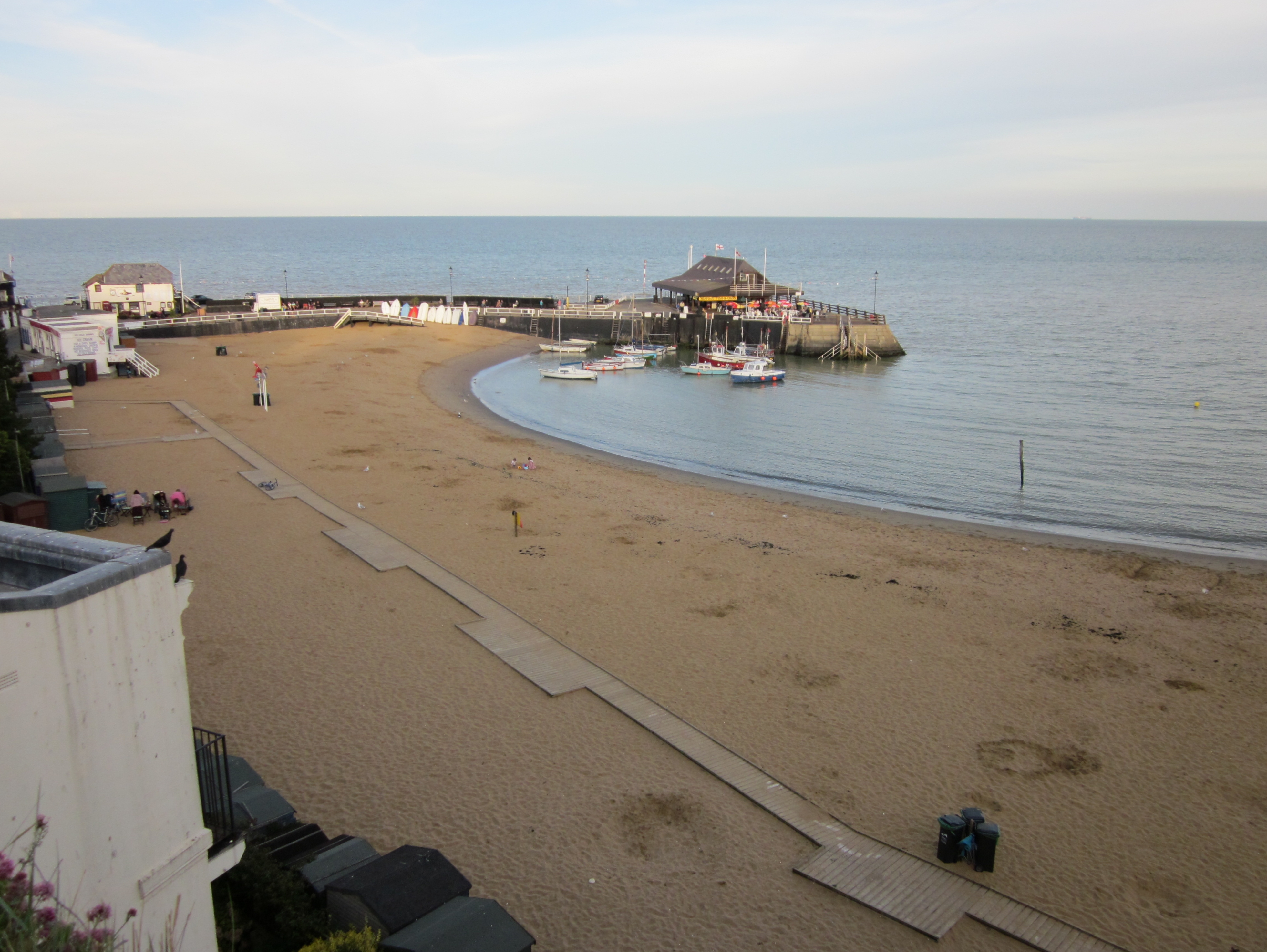
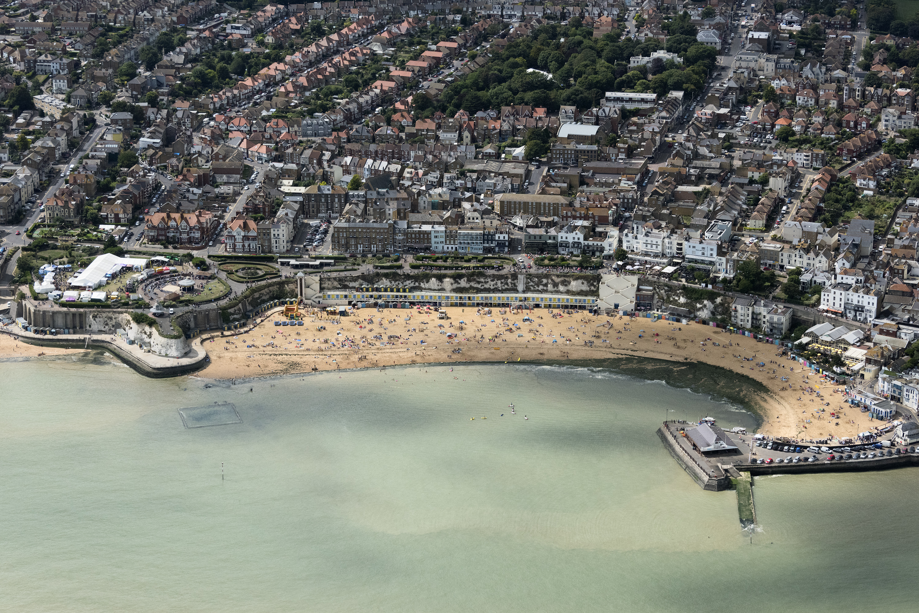
Dumpton Point is a prominent coastal feature located in the county of Kent, England. It is classified as a headland and point due to its unique geographical structure and position along the coast. Situated near the town of Broadstairs, Dumpton Point is a popular destination for locals and visitors alike, offering breathtaking views of the English Channel.

The headland is characterized by its steep cliffs, which rise dramatically from the sea, providing a striking backdrop to the surrounding landscape. These cliffs, composed mainly of chalk and limestone, are known for their white appearance, contrasting beautifully with the deep blue of the sea. The height of the cliffs also makes Dumpton Point an ideal spot for birdwatching, as it provides a vantage point for observing various seabird species in their natural habitat.

In addition to its geological significance, Dumpton Point is also home to a diverse range of flora and fauna. The surrounding area is covered in lush vegetation, including grasses, wildflowers, and shrubs, creating a vibrant and colorful landscape. The headland acts as a natural barrier, sheltering the adjacent beaches from strong winds and creating a microclimate that supports a variety of plant species.

Access to Dumpton Point is relatively easy, with well-maintained footpaths leading visitors to the headland and its viewpoints. The site is also connected to a network of coastal trails, allowing for further exploration of the surrounding area. Whether it's for a leisurely walk, birdwatching, or simply enjoying the picturesque scenery, Dumpton Point offers an unforgettable coastal experience for all who visit.

If you have any feedback on the listing, please let us know in the comments section below.

Dumpton Point Images

Images are sourced within 2km of 51.351064/1.4434429 or Grid Reference TR3966. Thanks to Geograph Open Source API. All images are credited.

Below East Cliff, Broadstairs This whole bay and the wave-cut platform are all submerged at high tide.
Below East Cliff, Broadstairs
This whole bay and the wave-cut platform are all submerged at high tide.
Foreshore at Stone Bay The sandy beach transforms into a rock platform at low tide.
Foreshore at Stone Bay
The sandy beach transforms into a rock platform at low tide.
Stone Bay, Broadstairs Looking along the full length from the harbour jetty with Hope Point and North Foreland in the distance. Note the sewage discharge pipe at the beginning of the rocks, hopefully no longer in use!
Stone Bay, Broadstairs
Looking along the full length from the harbour jetty with Hope Point and North Foreland in the distance. Note the sewage discharge pipe at the beginning of the rocks, hopefully no longer in use!
Turnstone on the landing slip, Broadstairs Taking refuge after being chased along the beach by a dog.
Turnstone on the landing slip, Broadstairs
Taking refuge after being chased along the beach by a dog.
Broadstairs Sailing Club A decent wind without too much sea running. Mainly Laser class one-man dinghies with a Contender far right.
Broadstairs Sailing Club
A decent wind without too much sea running. Mainly Laser class one-man dinghies with a Contender far right.
Rocks at Low Tide This square just avoids being in the All At Sea category with a small area of weed covered rock getting exposed at low tide. At high tide it's only the beacon at the end of the nearby slipway that isn't under water.
Rocks at Low Tide
This square just avoids being in the All At Sea category with a small area of weed covered rock getting exposed at low tide. At high tide it's only the beacon at the end of the nearby slipway that isn't under water.
White Rocks, Green Weed These strange rounded chalk boulders topped with soft green seaweed emerge at low tide. Some of them definitely resemble dummy heads wearing green wigs.
White Rocks, Green Weed
These strange rounded chalk boulders topped with soft green seaweed emerge at low tide. Some of them definitely resemble dummy heads wearing green wigs.
Beach Cricket at Low Tide An evening game on a rather soggy pitch down by the pier.
Beach Cricket at Low Tide
An evening game on a rather soggy pitch down by the pier.
Dog walker on Stone Bay
Rocks at Stone Bay, Broadstairs
East Cliff, Broadstairs
Stone Bay, Broadstairs
Coastal View at Broadstairs View north towards East Cliff.
Coastal View at Broadstairs
View north towards East Cliff.
Breakwater at Broadstairs This beacon warns shipping from coming to close to the land and Broadstairs Pier. This breakwater is only seen at low tide.

Also seen in <a href="https://www.geograph.org.uk/photo/1931281">TR4067 : Walking on the Breakwater</a>
Breakwater at Broadstairs
This beacon warns shipping from coming to close to the land and Broadstairs Pier. This breakwater is only seen at low tide. Also seen in TR4067 : Walking on the Breakwater
Broadstairs Pier As seen from the breakwater.
Broadstairs Pier
As seen from the breakwater.
Show me another place!

Dumpton Point is located at Grid Ref: TR3966 (Lat: 51.351064, Lng: 1.4434429)

Administrative County: Kent

District: Thanet

Police Authority: Kent

What 3 Words

///stress.pasta.grid. Near Broadstairs, Kent

Related Wikis

East Kent College

Broadstairs East Kent College is a further education college (although also provides higher education courses) located in Broadstairs, Kent on the southeast...

Holy Cross R.C. Secondary School

Holy Cross R.C. Secondary School (1962–1998) was a former Roman Catholic Secondary modern school and sixth form college located in Broadstairs, Kent, it...

Culmer White

The Culmer White was a 19th-century lifeboat of the Isle of Thanet, Kent, England. With its sister boat, the Mary White, it took part in the rescue of...

Mary White (lifeboat)

The Mary White was a lifeboat based in Broadstairs, Kent, England, named in 1851 after the completion of an heroic rescue of a brig, the Mary White. The...

Broadstairs

Broadstairs is a coastal town on the Isle of Thanet in the Thanet district of east Kent, England, about 80 miles (130 km) east of London. It is part of...

Palace Cinema, Broadstairs

The Palace Cinema is an independent single-screen cinema in Broadstairs, Kent, England. Housed in a converted commercial building, it opened in 1965 as...

Shrine of Our Lady, Bradstowe

The Shrine of Our Ladye Star of the Sea was an old chapel on the cliffs at Broadstairs (which was formerly known as Bradstowe). Dating back at least to...

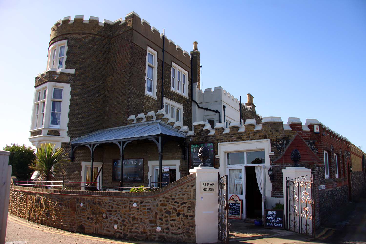
Bleak House, Broadstairs

Bleak House (originally known as Fort House) is a prominent house on the cliff overlooking the North Foreland and Viking Bay in Broadstairs, Kent. It was...

Nearby Amenities

Located within 500m of 51.351064,1.4434429
Bicycle Parking
Bicycle Parking: stands
Capacity: 4
Covered: no
Cyclestreets Id: 26969
Lat/Long: 51.3554396/1.4417629
Viking Guest House
Addr City: Broadstairs
Addr County: Kent
Addr Postcode: CT10 1QA
Addr Street: West Cliff Avenue
Fhrs Id: 658456
Phone: +44 1843 862375
Source Addr: http://www.viking-guesthouse.co.uk/
Tourism: guest_house
Website: http://www.viking-guesthouse.co.uk/
Lat/Long: 51.3551124/1.4410607
Millennium Milepost Broadstairs
Description: 1) Broadstairs 0.75, Margate 6 2) Ramsgate 1.5, Sandwich 8
Image: https://www.cyclestreets.net/location/194758/cyclestreets194758-size640.jpg
Information: guidepost
Ncn Milepost: rowe
Sustrans Ref: MP 788
Tourism: information
Lat/Long: 51.3488043/1.4379481
Addr City: Broadstairs
Addr Housenumber: 68
Addr Street: West Cliff Road
Name Signed: no
Phone Signed: no
Tourism: guest_house
Lat/Long: 51.3546783/1.4413869
Bus Stop
Waldron Road
Bench: no
Flag: yes
Local Ref: adj
Naptan AtcoCode: 2400100336
Naptan Bearing: SW
Naptan BusStopType: MKD
Naptan CommonName: Waldron Road
Naptan Indicator: adj
Naptan Landmark: Waldron Road
Naptan NaptanCode: kntgtgpw
Naptan PlusbusZoneRef: THANET
Naptan RevisionNumber: 2
Naptan Status: act
Naptan Street: Dumpton Park Drive
Naptan Verified: no
Public Transport: platform
Ref: kntgtgpw
Shelter: no
Source: naptan_import
Source Date: 2018-08-28
Tactile Paving: no
Lat/Long: 51.3512113/1.4384657
Bus Stop
Waldron Road
Bench: no
Flag: yes
Local Ref: opp
Naptan AtcoCode: 2400100338
Naptan Bearing: NE
Naptan BusStopType: MKD
Naptan CommonName: Waldron Road
Naptan Indicator: opp
Naptan Landmark: Waldron Road
Naptan NaptanCode: kntgwgtm
Naptan PlusbusZoneRef: THANET
Naptan RevisionNumber: 1
Naptan Status: act
Naptan Street: Dumpton Park Drive
Naptan Verified: no
Public Transport: platform
Ref: kntgwgtm
Shelter: no
Source: naptan_import
Source Date: 2018-08-28
Lat/Long: 51.3513817/1.4384964
Bus Stop
Palmerston Avenue
Bench: no
Bin: no
Flag: yes
Local Ref: adj
Naptan AtcoCode: 2400A047380A
Naptan Bearing: SW
Naptan BusStopType: MKD
Naptan CommonName: Palmerston Avenue
Naptan Indicator: adj
Naptan Landmark: Palmerston Avenue
Naptan NaptanCode: kntdwtjm
Naptan PlusbusZoneRef: THANET
Naptan RevisionNumber: 3
Naptan Status: act
Naptan Street: Dumpton Park Drive
Naptan Verified: no
Public Transport: platform
Ref: kntdwtjm
Shelter: no
Source: naptan_import
Source Date: 2018-02-12
Tactile Paving: no
Lat/Long: 51.3536573/1.4404948
Bus Stop
Palmerston Avenue
Bench: no
Bin: no
Flag: yes
Local Ref: opp
Naptan AtcoCode: 2400A047390A
Naptan Bearing: NE
Naptan BusStopType: MKD
Naptan CommonName: Palmerston Avenue
Naptan Indicator: opp
Naptan Landmark: Palmerston Avenue
Naptan NaptanCode: kntdwtjp
Naptan PlusbusZoneRef: THANET
Naptan RevisionNumber: 3
Naptan Status: act
Naptan Street: Dumpton Park Drive
Naptan Verified: no
Public Transport: platform
Ref: kntdwtjp
Shelter: no
Source: naptan_import
Source Date: 2018-02-12
Tactile Paving: no
Lat/Long: 51.3536024/1.4400991
Post Box
Post Box Type: wall
Postal Code: CT10
Ref: CT10 101
Royal Cypher: EVIIR
Royal Cypher Wikidata: Q33102324
Source: survey
Lat/Long: 51.3490819/1.4395216
Post Box
Drive Through: no
Operator: Royal Mail
Operator Wikidata: Q638098
Post Box Type: pillar
Postal Code: CT10
Ref: CT10 111
Royal Cypher: GR
Royal Cypher Wikidata: Q33102273
Source: survey
Lat/Long: 51.3525645/1.4397847
Cafe
Dumpton Gap Kiosk
Cuisine: ice_cream
Fixme: fix opening_hours. Which summer months?"
Opening Hours: "summer months"
Smoking: yes
Wheelchair: yes
Lat/Long: 51.3486116/1.4393592
Seats: 2
Tourism: viewpoint
Lat/Long: 51.3481269/1.4387433
Toilets
Lat/Long: 51.3486222/1.4388754
Broastairs Coast
Board Type: map
Check Date: 2021-05-31
Information: board
Source: survey
Tourism: information
Lat/Long: 51.3492512/1.4412913
Source: inspection
Tourism: viewpoint
Lat/Long: 51.3491568/1.4411071
Source: inspection
Tourism: viewpoint
Lat/Long: 51.3547914/1.4430249
Shelter
Source: survey
Lat/Long: 51.3489544/1.4397871
Broadstairs & St Peter's Town Council
Board Type: notice
Check Date: 2021-05-31
Information: board
Source: survey
Tourism: information
Lat/Long: 51.348817/1.4380677
Tourist Information
Check Date: 2021-05-31
Information: map
Source: survey
Tourism: information
Lat/Long: 51.3487472/1.4382163
Barrier: bollard
Bicycle: yes
Bollard: fixed
Foot: yes
Source: survey
Lat/Long: 51.349296/1.4412454
Barrier: bollard
Bicycle: no
Bollard: fixed
Foot: yes
Source: survey
Lat/Long: 51.3489962/1.4408866
Barrier: bollard
Bicycle: yes
Foot: yes
Source: survey
Lat/Long: 51.3546346/1.4429185
Barrier: bollard
Bicycle: yes
Foot: yes
Source: survey
Lat/Long: 51.3546312/1.4429588
Shelter
Source: survey
Lat/Long: 51.3512298/1.4419926
Generator Method: photovoltaic
Generator Output Electricity: yes
Generator Source: solar
Generator Type: solar_photovoltaic_panel
Location: roof
Power: generator
Lat/Long: 51.3505071/1.4372241
Generator Method: photovoltaic
Generator Output Electricity: yes
Generator Source: solar
Generator Type: solar_photovoltaic_panel
Location: roof
Power: generator
Lat/Long: 51.3534503/1.4380932
Generator Method: photovoltaic
Generator Output Electricity: yes
Generator Source: solar
Generator Type: solar_photovoltaic_panel
Location: roof
Power: generator
Lat/Long: 51.3516362/1.4384352
Generator Method: photovoltaic
Generator Output Electricity: yes
Generator Source: solar
Generator Type: solar_photovoltaic_panel
Location: roof
Power: generator
Lat/Long: 51.3538657/1.4410168
Generator Method: photovoltaic
Generator Output Electricity: yes
Generator Source: solar
Generator Type: solar_photovoltaic_panel
Location: roof
Power: generator
Lat/Long: 51.3540081/1.4410356
Generator Method: photovoltaic
Generator Output Electricity: yes
Generator Source: solar
Generator Type: solar_photovoltaic_panel
Location: roof
Power: generator
Lat/Long: 51.3539026/1.441521
Generator Method: photovoltaic
Generator Output Electricity: yes
Generator Source: solar
Generator Type: solar_photovoltaic_panel
Location: roof
Power: generator
Lat/Long: 51.3545006/1.440534
Dumpton Gap
Place: quarter
Lat/Long: 51.3488202/1.4381978
Bus Stop
Leybourn Road
Bench: no
Flag: yes
Naptan AtcoCode: 2400107923
Naptan Bearing: S
Naptan CommonName: Leybourn Road
Naptan Indicator: opp
Naptan Landmark: Leybourn Road
Naptan NaptanCode: kntjwmpa
Naptan Street: Western Esplanade
Naptan Verified: no
Public Transport: platform
Ref: kntjwmpa
Shelter: no
Source: NAPTAN
Source Date: 2018-02-02T13:49:00
Tactile Paving: no
Lat/Long: 51.3512856/1.4417645
Bus Stop
Buckmaster House
Bench: no
Departures Board: timetable
Flag: yes
Naptan AtcoCode: 2400107921
Naptan Bearing: N
Naptan CommonName: Buckmaster House
Naptan Indicator: adj
Naptan Landmark: Buckmaster House
Naptan NaptanCode: kntjwmjw
Naptan Street: Western Esplanade
Passenger Information Display: no
Public Transport: platform
Ref: kntjwmjw
Shelter: no
Source: NAPTAN
Source Date: 2017-05-23T15:39:00
Tactile Paving: no
Lat/Long: 51.35269/1.4417262
Bus Stop
Seapoint Road
Bench: no
Departures Board: timetable
Flag: yes
Local Ref: adj
Naptan AtcoCode: 2400107925
Naptan Bearing: N
Naptan BusStopType: MKD
Naptan CommonName: Seapoint Road
Naptan Indicator: adj
Naptan Landmark: Seapoint Road
Naptan NaptanCode: kntjwmpd
Naptan RevisionNumber: 3
Naptan Status: act
Naptan Street: Western Esplanade
Naptan Verified: no
Passenger Information Display: no
Public Transport: platform
Ref: kntjwmpd
Shelter: no
Source: naptan_import
Source Date: 2017-05-23
Tactile Paving: no
Lat/Long: 51.3541563/1.4426407
Bus Stop
Seapoint Road
Bench: yes
Flag: yes
Local Ref: opp
Naptan AtcoCode: 2400107927
Naptan Bearing: S
Naptan CommonName: Seapoint Road
Naptan Indicator: opp
Naptan Landmark: Seapoint Road
Naptan NaptanCode: kntjwmpg
Naptan RevisionNumber: 3
Naptan Status: act
Naptan Street: Western Esplanade
Naptan Verified: no
Public Transport: platform
Ref: kntjwmpg
Shelter: no
Source: naptan_import
Source Date: 2017-05-23
Tactile Paving: no
Lat/Long: 51.3543466/1.4428992
Bus Stop
South Cliff Parade
Bench: no
Bin: no
Departures Board: timetable
Flag: yes
Lit: yes
Local Ref: adj
Naptan AtcoCode: 2400107919
Naptan Bearing: W
Naptan BusStopType: MKD
Naptan CommonName: South Cliff Parade
Naptan Indicator: adj
Naptan Landmark: South Cliff Parade
Naptan NaptanCode: kntjwmjt
Naptan RevisionNumber: 3
Naptan Status: act
Naptan Street: Western Esplanade
Naptan Verified: no
Passenger Information Display: no
Public Transport: platform
Ref: kntjwmjt
Shelter: no
Source: naptan_import
Source Date: 2018-08-28
Tactile Paving: no
Lat/Long: 51.348844/1.4385626
Bus Stop
South Cliff Parade
Local Ref: opp
Naptan AtcoCode: 2400107917
Naptan Bearing: E
Naptan BusStopType: MKD
Naptan CommonName: South Cliff Parade
Naptan Indicator: opp
Naptan Landmark: South Cliff Parade
Naptan NaptanCode: kntjwmjp
Naptan RevisionNumber: 2
Naptan Status: act
Naptan Street: Western Esplanade
Naptan Verified: no
Public Transport: platform
Ref: kntjwmjp
Shelter: no
Source: naptan_import
Source Date: 2017-05-23
Lat/Long: 51.3489457/1.4381676
Crossing
Crossing: unmarked
Crossing Island: yes
Crossing Markings: no
Tactile Paving: yes
Lat/Long: 51.3516773/1.4392545
Bench
Backrest: yes
Colour: black and brown
Material: steel and wood
Lat/Long: 51.3545874/1.4430474
Bench
Backrest: yes
Colour: brown
Material: wood
Lat/Long: 51.3545556/1.4430635
Bicycle Parking
Capacity: 3
Lat/Long: 51.3546176/1.443034
Crossing
Crossing: unmarked
Crossing Markings: no
Lat/Long: 51.3522328/1.4397909
Crossing
Crossing: unmarked
Crossing Markings: no
Lat/Long: 51.3543167/1.4408666
Crossing
Crossing: unmarked
Crossing Markings: no
Lat/Long: 51.3547352/1.4409504
The data included in this document is from www.openstreetmap.org. The data is made available under ODbL.

Have you been to Dumpton Point?

Leave your review of Dumpton Point below (or comments, questions and feedback).