South Cliff

Cliff, Slope in Kent Thanet

England

South Cliff

Below East Cliff, Broadstairs This whole bay and the wave-cut platform are all submerged at high tide.
Below East Cliff, Broadstairs Credit: Trevor Harris

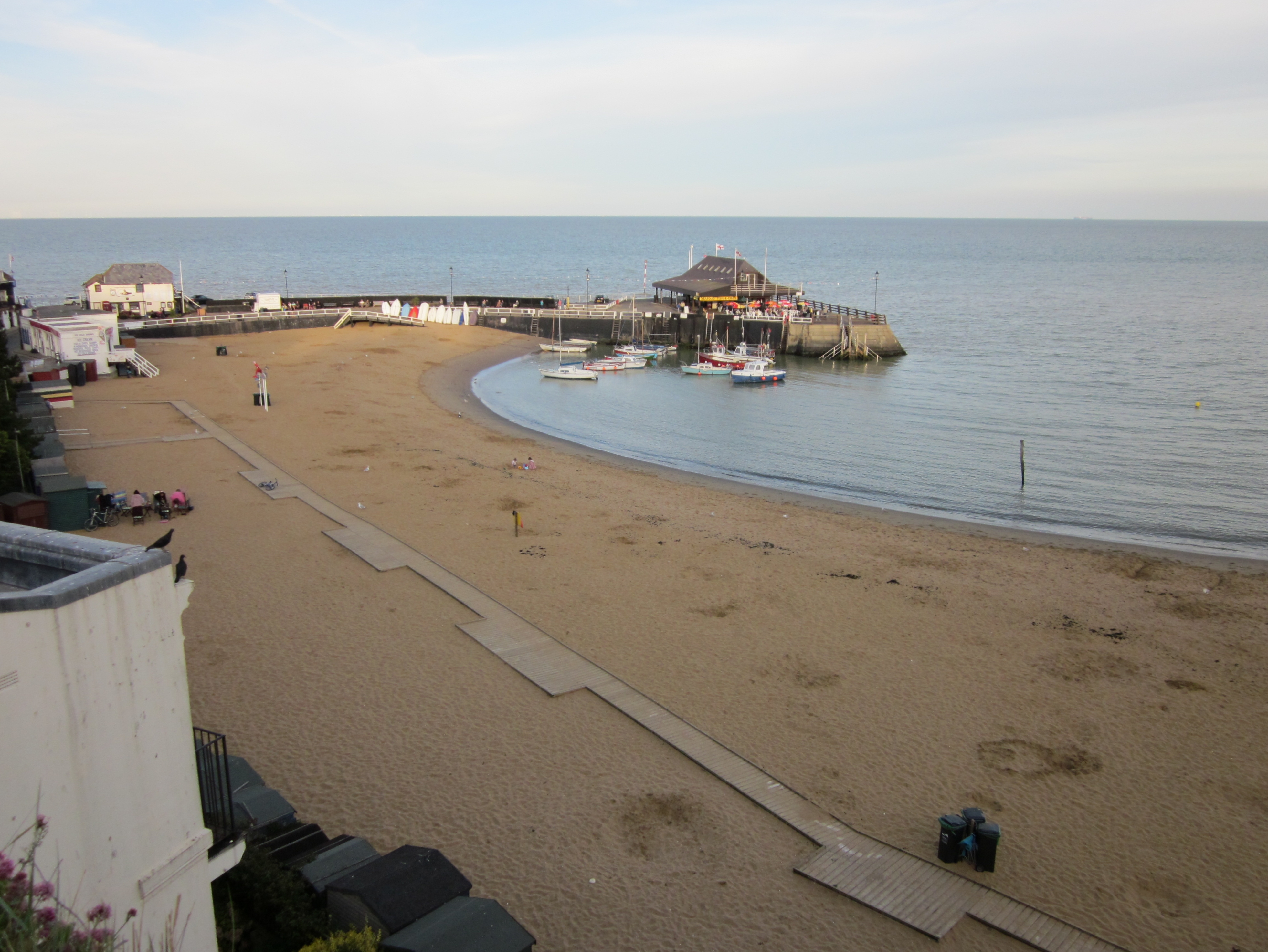
South Cliff, located in Kent, England, is a picturesque coastal area known for its stunning cliffs and sloping landscapes. Situated near the town of Folkestone, South Cliff offers breathtaking views of the English Channel and the surrounding countryside.

The cliffs of South Cliff are made up of chalk and reach heights of up to 100 meters, creating a dramatic and awe-inspiring sight. These chalk cliffs are an iconic part of the area's natural beauty and have become a symbol of the English coastline.

The sloping landscapes of South Cliff are dotted with lush greenery and wildflowers, providing a haven for local wildlife and a perfect setting for leisurely walks. Visitors can explore the well-maintained footpaths that crisscross the area, taking in the scenic vistas and enjoying the fresh sea air.

South Cliff also boasts a variety of recreational activities for outdoor enthusiasts. The cliffs provide excellent opportunities for rock climbing, attracting climbers from near and far. Additionally, the nearby beach allows for swimming, sunbathing, and picnicking during the warmer months.

For those interested in history, South Cliff is home to several interesting landmarks. The Leas Lift, a funicular railway built in 1885, still operates and offers a nostalgic way to ascend the cliffs. Meanwhile, the Battle of Britain Memorial, located on the cliff top, pays tribute to the brave pilots who defended the skies during World War II.

Overall, South Cliff in Kent is a captivating destination that combines natural beauty, outdoor activities, and historical significance. Whether visitors are seeking adventure, relaxation, or a glimpse into the past, South Cliff has something to offer everyone.

If you have any feedback on the listing, please let us know in the comments section below.

South Cliff Images

Images are sourced within 2km of 51.348927/1.4408407 or Grid Reference TR3966. Thanks to Geograph Open Source API. All images are credited.

Below East Cliff, Broadstairs This whole bay and the wave-cut platform are all submerged at high tide.
Below East Cliff, Broadstairs
This whole bay and the wave-cut platform are all submerged at high tide.
Foreshore at Stone Bay The sandy beach transforms into a rock platform at low tide.
Foreshore at Stone Bay
The sandy beach transforms into a rock platform at low tide.
Stone Bay, Broadstairs Looking along the full length from the harbour jetty with Hope Point and North Foreland in the distance. Note the sewage discharge pipe at the beginning of the rocks, hopefully no longer in use!
Stone Bay, Broadstairs
Looking along the full length from the harbour jetty with Hope Point and North Foreland in the distance. Note the sewage discharge pipe at the beginning of the rocks, hopefully no longer in use!
Turnstone on the landing slip, Broadstairs Taking refuge after being chased along the beach by a dog.
Turnstone on the landing slip, Broadstairs
Taking refuge after being chased along the beach by a dog.
Broadstairs Sailing Club A decent wind without too much sea running. Mainly Laser class one-man dinghies with a Contender far right.
Broadstairs Sailing Club
A decent wind without too much sea running. Mainly Laser class one-man dinghies with a Contender far right.
Rocks at Low Tide This square just avoids being in the All At Sea category with a small area of weed covered rock getting exposed at low tide. At high tide it's only the beacon at the end of the nearby slipway that isn't under water.
Rocks at Low Tide
This square just avoids being in the All At Sea category with a small area of weed covered rock getting exposed at low tide. At high tide it's only the beacon at the end of the nearby slipway that isn't under water.
White Rocks, Green Weed These strange rounded chalk boulders topped with soft green seaweed emerge at low tide. Some of them definitely resemble dummy heads wearing green wigs.
White Rocks, Green Weed
These strange rounded chalk boulders topped with soft green seaweed emerge at low tide. Some of them definitely resemble dummy heads wearing green wigs.
Beach Cricket at Low Tide An evening game on a rather soggy pitch down by the pier.
Beach Cricket at Low Tide
An evening game on a rather soggy pitch down by the pier.
Dog walker on Stone Bay
Rocks at Stone Bay, Broadstairs
Stone Bay, Broadstairs
Coastal View at Broadstairs View north towards East Cliff.
Coastal View at Broadstairs
View north towards East Cliff.
Breakwater at Broadstairs This beacon warns shipping from coming to close to the land and Broadstairs Pier. This breakwater is only seen at low tide.

Also seen in <a href="https://www.geograph.org.uk/photo/1931281">TR4067 : Walking on the Breakwater</a>
Breakwater at Broadstairs
This beacon warns shipping from coming to close to the land and Broadstairs Pier. This breakwater is only seen at low tide. Also seen in TR4067 : Walking on the Breakwater
Broadstairs Pier As seen from the breakwater.
Broadstairs Pier
As seen from the breakwater.
East Cliff near Broadstairs As seen from the breakwater near Broadstairs Pier.
At lower tides, a small sandy beach can be seen.
East Cliff near Broadstairs
As seen from the breakwater near Broadstairs Pier. At lower tides, a small sandy beach can be seen.
Stone Bay, near Ramsgate
Hard, Broadstairs Harbour There is a very small harbour here, for small boats only, consisting of a short harbour arm protecting a patch of beach that dries out, with this ramp projecting from the outer side of the arm.  This allows small boats to come alongside at lower states of the tide.
Hard, Broadstairs Harbour
There is a very small harbour here, for small boats only, consisting of a short harbour arm protecting a patch of beach that dries out, with this ramp projecting from the outer side of the arm. This allows small boats to come alongside at lower states of the tide.
Slipway from Broadstairs pier
Show me another place!

South Cliff is located at Grid Ref: TR3966 (Lat: 51.348927, Lng: 1.4408407)

Administrative County: Kent

District: Thanet

Police Authority: Kent

What 3 Words

///coats.fakes.final. Near Broadstairs, Kent

Related Wikis

Holy Cross R.C. Secondary School

Holy Cross R.C. Secondary School (1962–1998) was a former Roman Catholic Secondary modern school and sixth form college located in Broadstairs, Kent, it...

East Kent College

Broadstairs East Kent College is a further education college (although also provides higher education courses) located in Broadstairs, Kent on the southeast...

Culmer White

The Culmer White was a 19th-century lifeboat of the Isle of Thanet, Kent, England. With its sister boat, the Mary White, it took part in the rescue of...

Mary White (lifeboat)

The Mary White was a lifeboat based in Broadstairs, Kent, England, named in 1851 after the completion of an heroic rescue of a brig, the Mary White. The...

Nearby Amenities

Located within 500m of 51.348927,1.4408407
Post Box
Post Box Type: lamp
Postal Code: CT10
Ref: CT10 150
Royal Cypher: EIIR
Royal Cypher Wikidata: Q33102113
Lat/Long: 51.3496294/1.4338226
Millennium Milepost Broadstairs
Description: 1) Broadstairs 0.75, Margate 6 2) Ramsgate 1.5, Sandwich 8
Image: https://www.cyclestreets.net/location/194758/cyclestreets194758-size640.jpg
Information: guidepost
Ncn Milepost: rowe
Sustrans Ref: MP 788
Tourism: information
Lat/Long: 51.3488043/1.4379481
Bus Stop
Waldron Road
Bench: no
Flag: yes
Local Ref: adj
Naptan AtcoCode: 2400100336
Naptan Bearing: SW
Naptan BusStopType: MKD
Naptan CommonName: Waldron Road
Naptan Indicator: adj
Naptan Landmark: Waldron Road
Naptan NaptanCode: kntgtgpw
Naptan PlusbusZoneRef: THANET
Naptan RevisionNumber: 2
Naptan Status: act
Naptan Street: Dumpton Park Drive
Naptan Verified: no
Public Transport: platform
Ref: kntgtgpw
Shelter: no
Source: naptan_import
Source Date: 2018-08-28
Tactile Paving: no
Lat/Long: 51.3512113/1.4384657
Bus Stop
Waldron Road
Bench: no
Flag: yes
Local Ref: opp
Naptan AtcoCode: 2400100338
Naptan Bearing: NE
Naptan BusStopType: MKD
Naptan CommonName: Waldron Road
Naptan Indicator: opp
Naptan Landmark: Waldron Road
Naptan NaptanCode: kntgwgtm
Naptan PlusbusZoneRef: THANET
Naptan RevisionNumber: 1
Naptan Status: act
Naptan Street: Dumpton Park Drive
Naptan Verified: no
Public Transport: platform
Ref: kntgwgtm
Shelter: no
Source: naptan_import
Source Date: 2018-08-28
Lat/Long: 51.3513817/1.4384964
Bus Stop
Hawkhurst Way
Bench: no
Bin: no
Flag: yes
Local Ref: opp
Naptan AtcoCode: 2400100340
Naptan Bearing: S
Naptan BusStopType: MKD
Naptan CommonName: Hawkhurst Way
Naptan Indicator: opp
Naptan Landmark: Hawkhurst Way
Naptan NaptanCode: kntgwjdt
Naptan PlusbusZoneRef: THANET
Naptan RevisionNumber: 3
Naptan Status: act
Naptan Street: Colburn Road
Naptan Verified: no
Public Transport: platform
Ref: kntgwjdt
Shelter: no
Source: naptan_import
Source Date: 2018-08-28
Tactile Paving: no
Lat/Long: 51.3486139/1.4347267
Bus Stop
Hawkhurst Way
Bench: no
Bin: no
Flag: yes
Local Ref: adj
Naptan AtcoCode: 2400A070970A
Naptan Bearing: N
Naptan BusStopType: MKD
Naptan CommonName: Hawkhurst Way
Naptan Indicator: adj
Naptan Landmark: Hawkhurst Way
Naptan NaptanCode: kntgdjwj
Naptan PlusbusZoneRef: THANET
Naptan RevisionNumber: 3
Naptan Status: act
Naptan Street: Colburn Road
Naptan Verified: no
Public Transport: platform
Ref: kntgdjwj
Shelter: no
Source: naptan_import
Source Date: 2018-08-28
Tactile Paving: no
Lat/Long: 51.3488938/1.4346902
Post Box
Post Box Type: lamp
Postal Code: CT10
Ref: CT10 151
Royal Cypher: EIIR
Royal Cypher Wikidata: Q33102113
Source: survey
Lat/Long: 51.3453856/1.437317
Post Box
Post Box Type: wall
Postal Code: CT10
Ref: CT10 101
Royal Cypher: EVIIR
Royal Cypher Wikidata: Q33102324
Source: survey
Lat/Long: 51.3490819/1.4395216
Post Box
Drive Through: no
Operator: Royal Mail
Operator Wikidata: Q638098
Post Box Type: pillar
Postal Code: CT10
Ref: CT10 111
Royal Cypher: GR
Royal Cypher Wikidata: Q33102273
Source: survey
Lat/Long: 51.3525645/1.4397847
Cafe
Dumpton Gap Kiosk
Cuisine: ice_cream
Fixme: fix opening_hours. Which summer months?"
Opening Hours: "summer months"
Smoking: yes
Wheelchair: yes
Lat/Long: 51.3486116/1.4393592
Seats: 2
Tourism: viewpoint
Lat/Long: 51.3481269/1.4387433
Toilets
Lat/Long: 51.3486222/1.4388754
Broastairs Coast
Board Type: map
Check Date: 2021-05-31
Information: board
Source: survey
Tourism: information
Lat/Long: 51.3492512/1.4412913
Source: inspection
Tourism: viewpoint
Lat/Long: 51.3491568/1.4411071
Shelter
Source: survey
Lat/Long: 51.3489544/1.4397871
Broadstairs & St Peter's Town Council
Board Type: notice
Check Date: 2021-05-31
Information: board
Source: survey
Tourism: information
Lat/Long: 51.348817/1.4380677
Tourist Information
Check Date: 2021-05-31
Information: map
Source: survey
Tourism: information
Lat/Long: 51.3487472/1.4382163
Barrier: bollard
Bicycle: yes
Bollard: fixed
Foot: yes
Source: survey
Lat/Long: 51.349296/1.4412454
Barrier: bollard
Bicycle: no
Bollard: fixed
Foot: yes
Source: survey
Lat/Long: 51.3489962/1.4408866
Shelter
Source: survey
Lat/Long: 51.3512298/1.4419926
Generator Method: photovoltaic
Generator Output Electricity: yes
Generator Source: solar
Generator Type: solar_photovoltaic_panel
Location: roof
Power: generator
Lat/Long: 51.3456019/1.436972
Generator Method: photovoltaic
Generator Output Electricity: yes
Generator Source: solar
Generator Type: solar_photovoltaic_panel
Location: roof
Power: generator
Lat/Long: 51.3457292/1.4371383
Generator Method: photovoltaic
Generator Output Electricity: yes
Generator Source: solar
Generator Type: solar_photovoltaic_panel
Location: roof
Power: generator
Lat/Long: 51.3467797/1.4359823
Generator Method: photovoltaic
Generator Output Electricity: yes
Generator Source: solar
Generator Type: solar_photovoltaic_panel
Location: roof
Power: generator
Lat/Long: 51.3467612/1.4359125
Generator Method: photovoltaic
Generator Output Electricity: yes
Generator Source: solar
Generator Type: solar_photovoltaic_panel
Location: roof
Power: generator
Lat/Long: 51.3467813/1.4357462
Generator Method: photovoltaic
Generator Output Electricity: yes
Generator Source: solar
Generator Type: solar_photovoltaic_panel
Location: roof
Power: generator
Lat/Long: 51.3491402/1.4354754
Generator Method: photovoltaic
Generator Output Electricity: yes
Generator Source: solar
Generator Type: solar_photovoltaic_panel
Location: roof
Power: generator
Lat/Long: 51.3505071/1.4372241
Generator Method: photovoltaic
Generator Output Electricity: yes
Generator Source: solar
Generator Type: solar_photovoltaic_panel
Location: roof
Power: generator
Lat/Long: 51.3512752/1.4347043
Generator Method: photovoltaic
Generator Output Electricity: yes
Generator Source: solar
Generator Type: solar_photovoltaic_panel
Location: roof
Power: generator
Lat/Long: 51.3512903/1.4348075
Generator Method: photovoltaic
Generator Output Electricity: yes
Generator Source: solar
Generator Type: solar_photovoltaic_panel
Location: roof
Power: generator
Lat/Long: 51.351715/1.4353312
Generator Method: photovoltaic
Generator Output Electricity: yes
Generator Source: solar
Generator Type: solar_photovoltaic_panel
Location: roof
Power: generator
Lat/Long: 51.3512953/1.4361392
Generator Method: photovoltaic
Generator Output Electricity: yes
Generator Source: solar
Generator Type: solar_photovoltaic_panel
Location: roof
Power: generator
Lat/Long: 51.3512869/1.4355102
Generator Method: photovoltaic
Generator Output Electricity: yes
Generator Source: solar
Generator Type: solar_photovoltaic_panel
Location: roof
Power: generator
Lat/Long: 51.351348/1.4354405
Generator Method: photovoltaic
Generator Output Electricity: yes
Generator Source: solar
Generator Type: solar_photovoltaic_panel
Location: roof
Power: generator
Lat/Long: 51.3510976/1.4347136
Generator Method: photovoltaic
Generator Output Electricity: yes
Generator Source: solar
Generator Type: solar_photovoltaic_panel
Location: roof
Power: generator
Lat/Long: 51.3496159/1.4349496
Generator Method: photovoltaic
Generator Output Electricity: yes
Generator Source: solar
Generator Type: solar_photovoltaic_panel
Location: roof
Power: generator
Lat/Long: 51.3497566/1.4339358
Generator Method: photovoltaic
Generator Output Electricity: yes
Generator Source: solar
Generator Type: solar_photovoltaic_panel
Location: roof
Power: generator
Lat/Long: 51.3511311/1.4351374
Generator Method: photovoltaic
Generator Output Electricity: yes
Generator Source: solar
Generator Type: solar_photovoltaic_panel
Location: roof
Power: generator
Lat/Long: 51.3516362/1.4384352
Generator Method: photovoltaic
Generator Output Electricity: yes
Generator Source: solar
Generator Type: solar_photovoltaic_panel
Location: roof
Power: generator
Lat/Long: 51.3511621/1.4351776
Traffic Calming: island
Lat/Long: 51.3507312/1.4362462
Dumpton Gap
Place: quarter
Lat/Long: 51.3488202/1.4381978
Bus Stop
Leybourn Road
Bench: no
Flag: yes
Naptan AtcoCode: 2400107923
Naptan Bearing: S
Naptan CommonName: Leybourn Road
Naptan Indicator: opp
Naptan Landmark: Leybourn Road
Naptan NaptanCode: kntjwmpa
Naptan Street: Western Esplanade
Naptan Verified: no
Public Transport: platform
Ref: kntjwmpa
Shelter: no
Source: NAPTAN
Source Date: 2018-02-02T13:49:00
Tactile Paving: no
Lat/Long: 51.3512856/1.4417645
Bus Stop
Buckmaster House
Bench: no
Departures Board: timetable
Flag: yes
Naptan AtcoCode: 2400107921
Naptan Bearing: N
Naptan CommonName: Buckmaster House
Naptan Indicator: adj
Naptan Landmark: Buckmaster House
Naptan NaptanCode: kntjwmjw
Naptan Street: Western Esplanade
Passenger Information Display: no
Public Transport: platform
Ref: kntjwmjw
Shelter: no
Source: NAPTAN
Source Date: 2017-05-23T15:39:00
Tactile Paving: no
Lat/Long: 51.35269/1.4417262
Bus Stop
South Cliff Parade
Bench: no
Bin: no
Departures Board: timetable
Flag: yes
Lit: yes
Local Ref: adj
Naptan AtcoCode: 2400107919
Naptan Bearing: W
Naptan BusStopType: MKD
Naptan CommonName: South Cliff Parade
Naptan Indicator: adj
Naptan Landmark: South Cliff Parade
Naptan NaptanCode: kntjwmjt
Naptan RevisionNumber: 3
Naptan Status: act
Naptan Street: Western Esplanade
Naptan Verified: no
Passenger Information Display: no
Public Transport: platform
Ref: kntjwmjt
Shelter: no
Source: naptan_import
Source Date: 2018-08-28
Tactile Paving: no
Lat/Long: 51.348844/1.4385626
Bus Stop
South Cliff Parade
Local Ref: opp
Naptan AtcoCode: 2400107917
Naptan Bearing: E
Naptan BusStopType: MKD
Naptan CommonName: South Cliff Parade
Naptan Indicator: opp
Naptan Landmark: South Cliff Parade
Naptan NaptanCode: kntjwmjp
Naptan RevisionNumber: 2
Naptan Status: act
Naptan Street: Western Esplanade
Naptan Verified: no
Public Transport: platform
Ref: kntjwmjp
Shelter: no
Source: naptan_import
Source Date: 2017-05-23
Lat/Long: 51.3489457/1.4381676
Bus Stop
Colburn Road
Bench: yes
Bin: no
Flag: yes
Local Ref: adj
Naptan AtcoCode: 2400102450
Naptan Bearing: W
Naptan BusStopType: MKD
Naptan CommonName: Colburn Road
Naptan Indicator: adj
Naptan Landmark: Colburn Road
Naptan NaptanCode: kntgtmpw
Naptan RevisionNumber: 0
Naptan Status: act
Naptan Street: Dumpton Gap Road
Naptan Verified: no
Public Transport: platform
Ref: kntgtmpw
Shelter: no
Source: naptan_import
Source Date: 2009-12-15
Tactile Paving: no
Lat/Long: 51.3494061/1.4343982
Bus Stop
Colburn Road
Bench: no
Bin: no
Departures Board: no
Flag: yes
Local Ref: opp
Naptan AtcoCode: 2400102448
Naptan Bearing: E
Naptan BusStopType: MKD
Naptan CommonName: Colburn Road
Naptan Indicator: opp
Naptan Landmark: Colburn Road
Naptan NaptanCode: kntgtmpt
Naptan RevisionNumber: 2
Naptan Status: act
Naptan Street: Dumpton Gap Road
Naptan Verified: no
Passenger Information Display: no
Public Transport: platform
Ref: kntgtmpt
Shelter: no
Source: naptan_import
Source Date: 2018-08-28
Tactile Paving: no
Lat/Long: 51.3496258/1.4338434
Crossing
Crossing: unmarked
Crossing Island: yes
Crossing Markings: no
Tactile Paving: yes
Lat/Long: 51.3516773/1.4392545
Crossing
Crossing: unmarked
Crossing Markings: no
Lat/Long: 51.3522328/1.4397909
The data included in this document is from www.openstreetmap.org. The data is made available under ODbL.

Have you been to South Cliff?

Leave your review of South Cliff below (or comments, questions and feedback).