Bink of Whiteshin

Coastal Feature, Headland, Point in Aberdeenshire

Scotland

Bink of Whiteshin

Guillemot Nap Time Guillemots taking a nap on the sheer cliffs of the Bullers of Buchan in Aberdeenshire.
Guillemot Nap Time Credit: Iain Smith

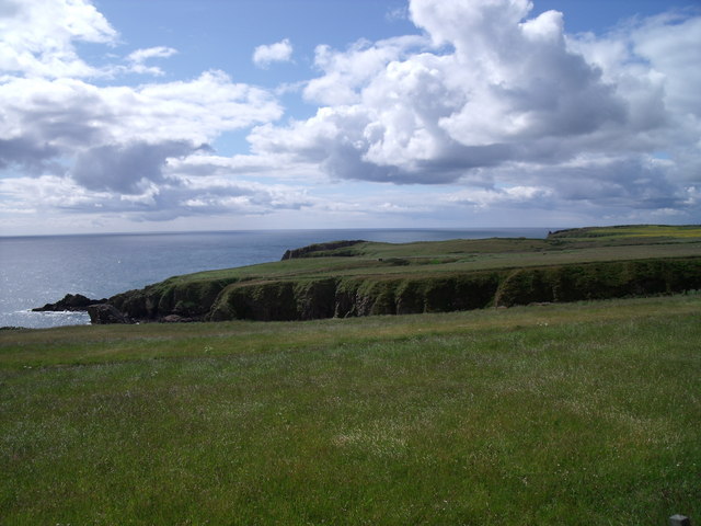
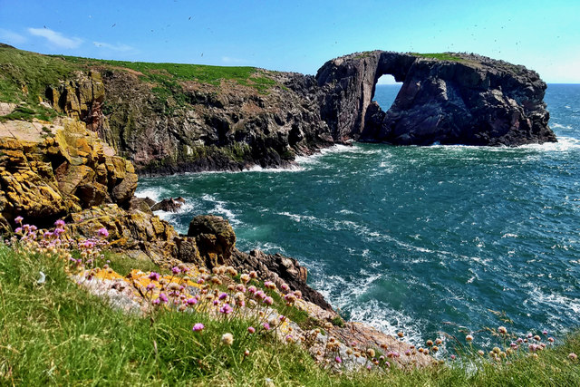
Bink of Whiteshin is a prominent coastal feature located in Aberdeenshire, Scotland. It is known for being a picturesque headland and point that offers breathtaking views of the North Sea. Situated along the rugged northeast coast of Scotland, it is a popular destination for nature enthusiasts and hikers who are drawn to its natural beauty.

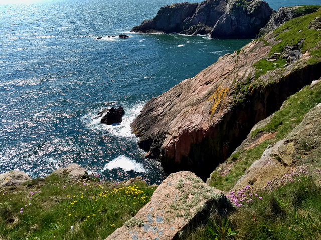
The Bink of Whiteshin stands at an elevation of approximately 100 meters above sea level, providing visitors with stunning panoramic vistas of the surrounding area. The headland is characterized by its steep cliffs, which are formed from rugged sandstone and shale, adding to its dramatic appeal.

The area is rich in wildlife, making it a haven for birdwatchers and nature lovers. Visitors may catch sight of various seabirds, such as gannets, puffins, and kittiwakes, as well as seals and dolphins that frequent the coastal waters. The coastal path that runs along the headland offers a great opportunity for exploration, with its diverse flora and fauna.

Bink of Whiteshin is also steeped in history, with remnants of ancient fortifications and settlements dotting the landscape. These archaeological sites tell the story of the area's past inhabitants, adding to its intrigue and charm.

Access to Bink of Whiteshin is relatively easy, with a well-maintained footpath leading to the headland. Visitors can enjoy leisurely walks, picnics, or simply take in the stunning vistas. The area is also a popular spot for photographers, as it offers numerous opportunities to capture the beauty of the Scottish coastline.

In conclusion, Bink of Whiteshin is a remarkable coastal feature in Aberdeenshire that offers breathtaking views, diverse wildlife, and a rich historical background. It is a must-visit destination for those seeking natural beauty and tranquility.

If you have any feedback on the listing, please let us know in the comments section below.

Bink of Whiteshin Images

Images are sourced within 2km of 57.43668/-1.8152466 or Grid Reference NK1138. Thanks to Geograph Open Source API. All images are credited.

Guillemot Nap Time Guillemots taking a nap on the sheer cliffs of the Bullers of Buchan in Aberdeenshire.
Guillemot Nap Time
Guillemots taking a nap on the sheer cliffs of the Bullers of Buchan in Aberdeenshire.
The Pot Looking into The Pot, a collapsed sea cave at the Bullers of Buchan. The North Sea is visible through the arch.
<span class="nowrap"><a title="http://bullersofbuchan.me.uk/" rel="nofollow ugc noopener" href="http://bullersofbuchan.me.uk/">Link</a><img style="margin-left:2px;" alt="External link" title="External link - shift click to open in new window" src="https://s1.geograph.org.uk/img/external.png" width="10" height="10"/></span>
The Pot
Looking into The Pot, a collapsed sea cave at the Bullers of Buchan. The North Sea is visible through the arch. LinkExternal link
Bullers o' Buchan Famous collapsed sea cave on the Buchan coast south of Peterhead.
<span class="nowrap"><a title="http://bullersofbuchan.me.uk/" rel="nofollow ugc noopener" href="http://bullersofbuchan.me.uk/">Link</a><img style="margin-left:2px;" alt="External link" title="External link - shift click to open in new window" src="https://s1.geograph.org.uk/img/external.png" width="10" height="10"/></span>
Bullers o' Buchan
Famous collapsed sea cave on the Buchan coast south of Peterhead. LinkExternal link
Track to Slains Castle, Cruden Bay
Puffin at the Bullers of Buchan Sadly, there seems to be less puffins this year than usual on the cliffs at the Bullers of Buchan. Possibly due to the very extreme weather whilst they were at sea this season.
Puffin at the Bullers of Buchan
Sadly, there seems to be less puffins this year than usual on the cliffs at the Bullers of Buchan. Possibly due to the very extreme weather whilst they were at sea this season.
The cliffs just south of Bullers of Buchan
At Bullers of Buchan
Bullers of Buchan
Bullers of Buchan
An overbridge and the track bed formation of the Buchan Railway above North Haven
Natural arch at Bullers of Buchan
Bullers of Buchan
Bullers of Buchan
Mussel Craig
Mussel Craig
Cairn-na-hilt
Cairn-na-hilt
Bullers of Buchan Erosion of the cliff into a sea arch.
Bullers of Buchan
Erosion of the cliff into a sea arch.
Old Railway Embankment An embankment and single bridge stanchion, remaining from the former Great North of Scotland Railway as the line headed north.
Old Railway Embankment
An embankment and single bridge stanchion, remaining from the former Great North of Scotland Railway as the line headed north.
Rocky coastline near Little Dumeath The photograph was taken from an A90 parking area. Notice the beautiful clouds.
Rocky coastline near Little Dumeath
The photograph was taken from an A90 parking area. Notice the beautiful clouds.
Back of Raplin
Back of Raplin
Show me another place!

Bink of Whiteshin is located at Grid Ref: NK1138 (Lat: 57.43668, Lng: -1.8152466)

Unitary Authority: Aberdeenshire

Police Authority: North East

What 3 Words

///everyone.consoles.consults. Near Cruden Bay, Aberdeenshire

Related Wikis

Bullers of Buchan

The name Bullers of Buchan refers both to a collapsed sea cave and to the adjacent village, situated about 6 miles (9.7 km) south of Peterhead in Buchan...

Bullers O'Buchan Platform railway station

Bullers O'Buchan Platform railway station also known as Bullers O'Buchan Halt railway station was a railway station serving visitors to the Bullers of...

Longhaven railway station

Longhaven railway station was a railway station in Longhaven, Aberdeen, serving passengers and goods on the line to Boddam. It opened with the branch in...

Longhaven

Longhaven is a village in Aberdeenshire, Scotland, located two miles southwest of Boddam.Longhaven railway station closed in 1948. The village had a primary...

RAF Buchan

Royal Air Force Buchan or more simply RAF Buchan is a former Royal Air Force station near Peterhead in Aberdeenshire, Scotland. Buchan opened in 1952 as...

RRH Buchan

Remote Radar Head Buchan or RRH Buchan is an air defence radar station operated by the Royal Air Force. It is located at Stirling Hill, 3.2 kilometres...

New Slains Castle

Slains Castle, also known as New Slains Castle to distinguish it from the nearby Old Slains Castle, is a ruined castle in Aberdeenshire, Scotland. It overlooks...

A90 road

The A90 road is a major north to south road in eastern Scotland, running from Edinburgh to Fraserburgh, through Dundee and Aberdeen. Along with the A9...

Nearby Amenities

Located within 500m of 57.43668,-1.8152466
Source: Old Landsat image trace
Lat/Long: 57.4390017/-1.8094308
Source: Old Landsat image trace
Lat/Long: 57.4388314/-1.8101336
Source: Old Landsat image trace
Lat/Long: 57.4381062/-1.8109981
Source: Old Landsat image trace
Lat/Long: 57.4377398/-1.8119958
Source: Old Landsat image trace
Lat/Long: 57.4370056/-1.8128479
Source: Old Landsat image trace
Lat/Long: 57.4370534/-1.8139623
Source: Old Landsat image trace
Lat/Long: 57.4379732/-1.813908
Source: Old Landsat image trace
Lat/Long: 57.4377299/-1.8143294
Source: Old Landsat image trace
Lat/Long: 57.4366457/-1.8147394
Source: Old Landsat image trace
Lat/Long: 57.4364497/-1.8166576
Source: Old Landsat image trace
Lat/Long: 57.4361586/-1.8170116
Source: Old Landsat image trace
Lat/Long: 57.4357393/-1.8187524
Source: Old Landsat image trace
Lat/Long: 57.4347477/-1.8183904
Source: Old Landsat image trace
Lat/Long: 57.43437/-1.8175793
Source: Old Landsat image trace
Lat/Long: 57.4332065/-1.8177626
Source: Old Landsat image trace
Lat/Long: 57.4329948/-1.8176493
Source: Old Landsat image trace
Lat/Long: 57.4323028/-1.8165759
North Haven
Natural: bay
Lat/Long: 57.4351569/-1.8191812
Barrier: block
Lat/Long: 57.438249/-1.8163813
Blockie Head Fort
Alt Name: Old Danish Fort
Description: Three or four ditches are identified as belong to this fort.
Historic: fort
Note: location is NK 1104 3826
Ref Canmore: 75948
Source: Canmore
Wikidata: Q31084142
Lat/Long: 57.4345019/-1.8177706
Girdle and Bakebread
Natural: cape
Lat/Long: 57.4378301/-1.8108943
Rotten Kaim
Natural: cape
Lat/Long: 57.4383209/-1.8093171
Bullers of Buchan
Natural: bay
Lat/Long: 57.4327784/-1.8176482
Power: pole
Lat/Long: 57.4385265/-1.8184355
Power: pole
Lat/Long: 57.4385746/-1.8195641
Power: pole
Lat/Long: 57.438607/-1.820593
Power: pole
Lat/Long: 57.4386417/-1.8216904
Perdonlie
Natural: bay
Lat/Long: 57.436903/-1.8143212
Dunnythagert
Natural: bay
Lat/Long: 57.4342514/-1.8170164
The Gutter
Natural: bay
Lat/Long: 57.4323689/-1.8162932
Board Type: nature
Information: board
Tourism: information
Lat/Long: 57.4329888/-1.8198941
The data included in this document is from www.openstreetmap.org. The data is made available under ODbL.

Have you been to Bink of Whiteshin?

Leave your review of Bink of Whiteshin below (or comments, questions and feedback).