Arthur Fowlie

Coastal Feature, Headland, Point in Aberdeenshire

Scotland

Arthur Fowlie

Guillemot Nap Time Guillemots taking a nap on the sheer cliffs of the Bullers of Buchan in Aberdeenshire.
Guillemot Nap Time Credit: Iain Smith

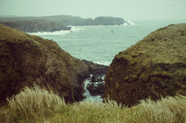
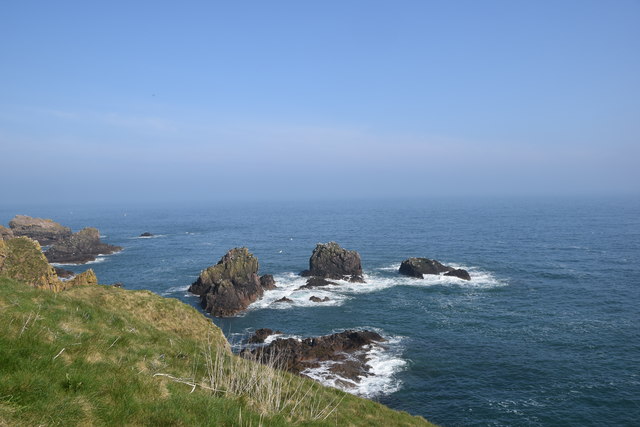
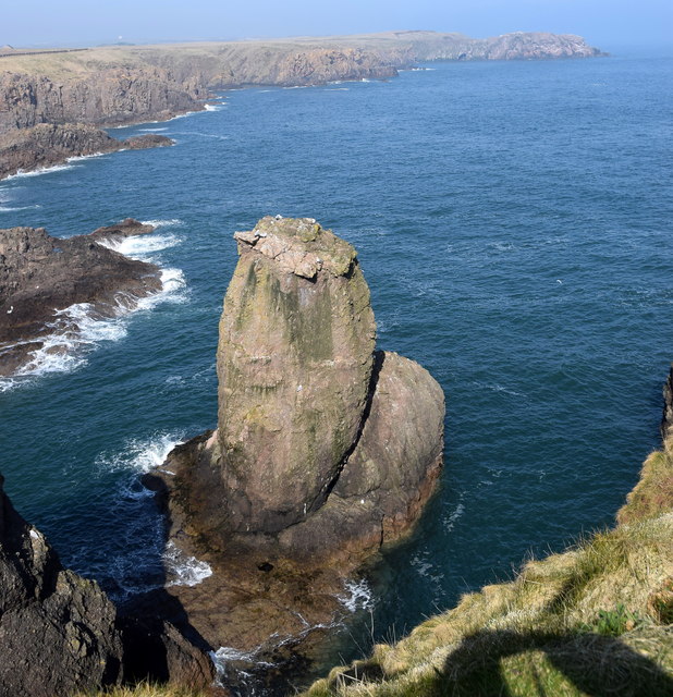
Arthur Fowlie is a prominent headland located in Aberdeenshire, Scotland. Situated on the picturesque coastal stretch of the North Sea, this coastal feature is known for its stunning natural beauty and rugged cliffs.

The headland is characterized by its steep slopes and towering cliffs that reach heights of up to 100 meters. These cliffs provide breathtaking views of the surrounding area, with the North Sea stretching out into the horizon and the dramatic coastline extending in both directions.

Arthur Fowlie is a popular destination for nature enthusiasts, hikers, and photographers who are drawn to its scenic vistas and diverse wildlife. The headland is home to a variety of seabirds, including puffins, guillemots, and kittiwakes, making it a haven for birdwatchers.

In addition to its natural beauty, Arthur Fowlie also holds historical significance. The headland is believed to have been a defensive site during ancient times, with remnants of Iron Age forts and settlements found in the surrounding area. These archaeological sites provide insight into the area's rich history and have attracted researchers and historians interested in understanding the region's past.

Access to Arthur Fowlie is relatively easy, with a well-maintained coastal path that allows visitors to explore the headland and enjoy its panoramic views. The nearby village of Cruden Bay offers amenities such as accommodations, cafes, and visitor information centers, making it a convenient base for those looking to explore this stunning coastal feature.

In conclusion, Arthur Fowlie in Aberdeenshire, Scotland, is a captivating headland known for its rugged cliffs, breathtaking views, and historical significance. It is a must-visit destination for nature lovers, hikers, and history enthusiasts alike.

If you have any feedback on the listing, please let us know in the comments section below.

Arthur Fowlie Images

Images are sourced within 2km of 57.430778/-1.8153596 or Grid Reference NK1137. Thanks to Geograph Open Source API. All images are credited.

Guillemot Nap Time Guillemots taking a nap on the sheer cliffs of the Bullers of Buchan in Aberdeenshire.
Guillemot Nap Time
Guillemots taking a nap on the sheer cliffs of the Bullers of Buchan in Aberdeenshire.
Long Haven Deep and extensive geo to the north of New Slains Castle.
Long Haven
Deep and extensive geo to the north of New Slains Castle.
The Pot Looking into The Pot, a collapsed sea cave at the Bullers of Buchan. The North Sea is visible through the arch.
<span class="nowrap"><a title="http://bullersofbuchan.me.uk/" rel="nofollow ugc noopener" href="http://bullersofbuchan.me.uk/">Link</a><img style="margin-left:2px;" alt="External link" title="External link - shift click to open in new window" src="https://s1.geograph.org.uk/img/external.png" width="10" height="10"/></span>
The Pot
Looking into The Pot, a collapsed sea cave at the Bullers of Buchan. The North Sea is visible through the arch. LinkExternal link
Bullers o' Buchan Famous collapsed sea cave on the Buchan coast south of Peterhead.
<span class="nowrap"><a title="http://bullersofbuchan.me.uk/" rel="nofollow ugc noopener" href="http://bullersofbuchan.me.uk/">Link</a><img style="margin-left:2px;" alt="External link" title="External link - shift click to open in new window" src="https://s1.geograph.org.uk/img/external.png" width="10" height="10"/></span>
Bullers o' Buchan
Famous collapsed sea cave on the Buchan coast south of Peterhead. LinkExternal link
Track to Slains Castle, Cruden Bay
Puffin at the Bullers of Buchan Sadly, there seems to be less puffins this year than usual on the cliffs at the Bullers of Buchan. Possibly due to the very extreme weather whilst they were at sea this season.
Puffin at the Bullers of Buchan
Sadly, there seems to be less puffins this year than usual on the cliffs at the Bullers of Buchan. Possibly due to the very extreme weather whilst they were at sea this season.
The cliffs just south of Bullers of Buchan
At Bullers of Buchan
Bullers of Buchan
Bullers of Buchan
An overbridge and the track bed formation of the Buchan Railway above North Haven
Natural arch at Bullers of Buchan
Bullers of Buchan
Bullers of Buchan
Mussel Craig
Mussel Craig
Cairn-na-hilt
Cairn-na-hilt
Bullers of Buchan Erosion of the cliff into a sea arch.
Bullers of Buchan
Erosion of the cliff into a sea arch.
Old Railway Embankment An embankment and single bridge stanchion, remaining from the former Great North of Scotland Railway as the line headed north.
Old Railway Embankment
An embankment and single bridge stanchion, remaining from the former Great North of Scotland Railway as the line headed north.
Coastal rocks View from the cliffs beside Slains Castle: I think these are called 'The Busks'.
Coastal rocks
View from the cliffs beside Slains Castle: I think these are called 'The Busks'.
The Sugar Loaf A distinctive rock at the entrance to Long Haven inlet, a couple of hundred metres north of Slains Castle.
The Sugar Loaf
A distinctive rock at the entrance to Long Haven inlet, a couple of hundred metres north of Slains Castle.
Show me another place!

Arthur Fowlie is located at Grid Ref: NK1137 (Lat: 57.430778, Lng: -1.8153596)

Unitary Authority: Aberdeenshire

Police Authority: North East

What 3 Words

///enjoys.edges.stay. Near Cruden Bay, Aberdeenshire

Related Wikis

Bullers of Buchan

The name Bullers of Buchan refers both to a collapsed sea cave and to the adjacent village, situated about 6 miles (9.7 km) south of Peterhead in Buchan...

Bullers O'Buchan Platform railway station

Bullers O'Buchan Platform railway station also known as Bullers O'Buchan Halt railway station was a railway station serving visitors to the Bullers of...

New Slains Castle

Slains Castle, also known as New Slains Castle to distinguish it from the nearby Old Slains Castle, is a ruined castle in Aberdeenshire, Scotland. It overlooks...

Longhaven railway station

Longhaven railway station was a railway station in Longhaven, Aberdeen, serving passengers and goods on the line to Boddam. It opened with the branch in...

Longhaven

Longhaven is a village in Aberdeenshire, Scotland, located two miles southwest of Boddam.Longhaven railway station closed in 1948. The village had a primary...

Cruden Bay

Cruden Bay is a small village in Scotland, on the north coast of the Bay of Cruden in Aberdeenshire, 26 miles (42 km) north of Aberdeen. Just west of Slains...

A90 road

The A90 road is a major north to south road in eastern Scotland, running from Edinburgh to Fraserburgh, through Dundee and Aberdeen. Along with the A9...

Water of Cruden

The Water of Cruden is a short broadly east-flowing river in Buchan in northeast Scotland. Its headwaters streams rise in the countryside north of Ellon...

Nearby Amenities

Located within 500m of 57.430778,-1.8153596
Source: Old Landsat image trace
Lat/Long: 57.4347477/-1.8183904
Source: Old Landsat image trace
Lat/Long: 57.43437/-1.8175793
Source: Old Landsat image trace
Lat/Long: 57.4332065/-1.8177626
Source: Old Landsat image trace
Lat/Long: 57.4329948/-1.8176493
Source: Old Landsat image trace
Lat/Long: 57.4323636/-1.8196849
Source: Old Landsat image trace
Lat/Long: 57.4323028/-1.8165759
Source: Old Landsat image trace
Lat/Long: 57.4319255/-1.8163133
Source: Old Landsat image trace
Lat/Long: 57.4319999/-1.8184956
Source: Old Landsat image trace
Lat/Long: 57.4312386/-1.8156892
Source: Old Landsat image trace
Lat/Long: 57.4306867/-1.8145118
Source: Old Landsat image trace
Lat/Long: 57.4303052/-1.8148095
Source: Old Landsat image trace
Lat/Long: 57.4300294/-1.8153111
Source: Old Landsat image trace
Lat/Long: 57.4298143/-1.8155697
Source: Old Landsat image trace
Lat/Long: 57.4297265/-1.815869
Source: Old Landsat image trace
Lat/Long: 57.4294677/-1.815767
Source: Old Landsat image trace
Lat/Long: 57.4292327/-1.816594
Source: Old Landsat image trace
Lat/Long: 57.4286626/-1.8164135
Source: OS7
Lat/Long: 57.4278889/-1.818401
Source: OS7
Lat/Long: 57.4265659/-1.8175588
Source: OS7
Lat/Long: 57.4269559/-1.8174786
Source: OS7
Lat/Long: 57.4269979/-1.8160946
Source: OS7
Lat/Long: 57.4278251/-1.8154227
Source: Old Landsat image trace
Lat/Long: 57.4284802/-1.8161921
Source: Old Landsat image trace
Lat/Long: 57.4305968/-1.8145361
Bullers of Buchan
Tourism: attraction
Wikidata: Q4996778
Wikipedia: en:Bullers of Buchan
Lat/Long: 57.4326056/-1.8199295
Bullers of Buchan
Place: hamlet
Wikidata: Q4996778
Wikipedia: en:Bullers of Buchan
Lat/Long: 57.432723/-1.8217534
Blockie Head Fort
Alt Name: Old Danish Fort
Description: Three or four ditches are identified as belong to this fort.
Historic: fort
Note: location is NK 1104 3826
Ref Canmore: 75948
Source: Canmore
Wikidata: Q31084142
Lat/Long: 57.4345019/-1.8177706
Gray Mare
Natural: cape
Lat/Long: 57.4275466/-1.8152359
Arthur Fowlie
Natural: cape
Lat/Long: 57.4308529/-1.8144565
Lammylair
Natural: bay
Lat/Long: 57.4280527/-1.816484
Bullers of Buchan
Natural: bay
Lat/Long: 57.4327784/-1.8176482
Rabie's Haven
Natural: bay
Lat/Long: 57.43171/-1.8170045
Dunnythagert
Natural: bay
Lat/Long: 57.4342514/-1.8170164
The Gutter
Natural: bay
Lat/Long: 57.4323689/-1.8162932
Board Type: nature
Information: board
Tourism: information
Lat/Long: 57.4329888/-1.8198941
The data included in this document is from www.openstreetmap.org. The data is made available under ODbL.

Have you been to Arthur Fowlie?

Leave your review of Arthur Fowlie below (or comments, questions and feedback).