The Stein

Coastal Feature, Headland, Point in Aberdeenshire

Scotland

The Stein

Guillemot Nap Time Guillemots taking a nap on the sheer cliffs of the Bullers of Buchan in Aberdeenshire.
Guillemot Nap Time Credit: Iain Smith

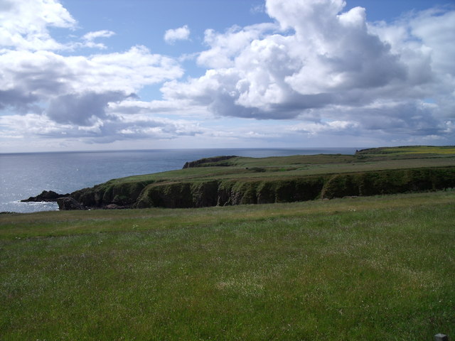
The Stein, located in Aberdeenshire, Scotland, is a prominent coastal feature that takes the form of a headland or point. It is situated along the picturesque North Sea coastline, approximately 20 miles north of the city of Aberdeen. The Stein is renowned for its rugged beauty, dramatic cliffs, and stunning views.

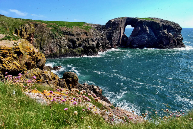
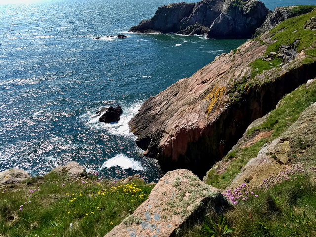
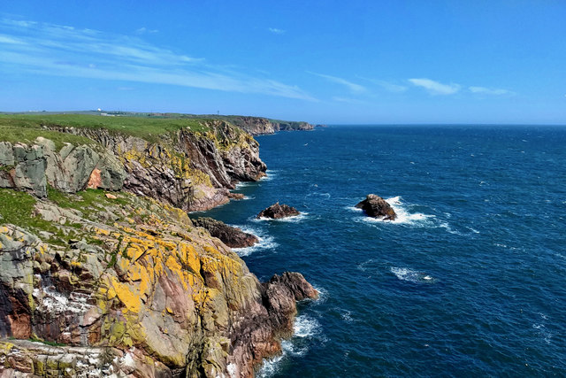
The headland is characterized by its towering cliffs, which reach heights of up to 150 feet, providing a commanding vantage point over the surrounding landscape. The cliffs are composed of sedimentary rock formations, showcasing layers of different geological eras. These formations are of significant interest to geologists and nature enthusiasts alike.

The Stein is also notable for its diverse wildlife. The surrounding area is home to various seabird species, including puffins, kittiwakes, and gannets. Visitors can observe these birds nesting on the cliffs or soaring above the crashing waves. Seals and dolphins are occasionally spotted in the nearby waters, adding to the area's natural charm.

Furthermore, the Stein offers excellent opportunities for outdoor activities such as hiking and photography. There are several well-maintained walking trails that wind along the edge of the cliffs, allowing visitors to explore the headland's unique landscape. Photographers are drawn to the area to capture the ever-changing light and the interplay between the cliffs and the sea.

Overall, the Stein in Aberdeenshire is a captivating coastal feature that showcases the raw beauty of Scotland's northeastern coastline. Its towering cliffs, diverse wildlife, and breathtaking views make it a must-visit destination for nature lovers and outdoor enthusiasts.

If you have any feedback on the listing, please let us know in the comments section below.

The Stein Images

Images are sourced within 2km of 57.441123/-1.8070782 or Grid Reference NK1138. Thanks to Geograph Open Source API. All images are credited.

Guillemot Nap Time Guillemots taking a nap on the sheer cliffs of the Bullers of Buchan in Aberdeenshire.
Guillemot Nap Time
Guillemots taking a nap on the sheer cliffs of the Bullers of Buchan in Aberdeenshire.
The Pot Looking into The Pot, a collapsed sea cave at the Bullers of Buchan. The North Sea is visible through the arch.
<span class="nowrap"><a title="http://bullersofbuchan.me.uk/" rel="nofollow ugc noopener" href="http://bullersofbuchan.me.uk/">Link</a><img style="margin-left:2px;" alt="External link" title="External link - shift click to open in new window" src="https://s1.geograph.org.uk/img/external.png" width="10" height="10"/></span>
The Pot
Looking into The Pot, a collapsed sea cave at the Bullers of Buchan. The North Sea is visible through the arch. LinkExternal link
Bullers o' Buchan Famous collapsed sea cave on the Buchan coast south of Peterhead.
<span class="nowrap"><a title="http://bullersofbuchan.me.uk/" rel="nofollow ugc noopener" href="http://bullersofbuchan.me.uk/">Link</a><img style="margin-left:2px;" alt="External link" title="External link - shift click to open in new window" src="https://s1.geograph.org.uk/img/external.png" width="10" height="10"/></span>
Bullers o' Buchan
Famous collapsed sea cave on the Buchan coast south of Peterhead. LinkExternal link
Puffin at the Bullers of Buchan Sadly, there seems to be less puffins this year than usual on the cliffs at the Bullers of Buchan. Possibly due to the very extreme weather whilst they were at sea this season.
Puffin at the Bullers of Buchan
Sadly, there seems to be less puffins this year than usual on the cliffs at the Bullers of Buchan. Possibly due to the very extreme weather whilst they were at sea this season.
The cliffs just south of Bullers of Buchan
At Bullers of Buchan
Bullers of Buchan
Bullers of Buchan
An overbridge and the track bed formation of the Buchan Railway above North Haven
Natural arch at Bullers of Buchan
Bullers of Buchan
Bullers of Buchan
Mussel Craig
Mussel Craig
Cairn-na-hilt
Cairn-na-hilt
Bullers of Buchan Erosion of the cliff into a sea arch.
Bullers of Buchan
Erosion of the cliff into a sea arch.
Old Railway Embankment An embankment and single bridge stanchion, remaining from the former Great North of Scotland Railway as the line headed north.
Old Railway Embankment
An embankment and single bridge stanchion, remaining from the former Great North of Scotland Railway as the line headed north.
Rocky coastline near Little Dumeath The photograph was taken from an A90 parking area. Notice the beautiful clouds.
Rocky coastline near Little Dumeath
The photograph was taken from an A90 parking area. Notice the beautiful clouds.
Back of Raplin
Back of Raplin
Long Craig
Long Craig
Show me another place!

The Stein is located at Grid Ref: NK1138 (Lat: 57.441123, Lng: -1.8070782)

Unitary Authority: Aberdeenshire

Police Authority: North East

What 3 Words

///windmills.record.oven. Near Boddam, Aberdeenshire

Related Wikis

Longhaven railway station

Longhaven railway station was a railway station in Longhaven, Aberdeen, serving passengers and goods on the line to Boddam. It opened with the branch in...

Bullers of Buchan

The name Bullers of Buchan refers both to a collapsed sea cave and to the adjacent village, situated about 6 miles (9.7 km) south of Peterhead in Buchan...

Bullers O'Buchan Platform railway station

Bullers O'Buchan Platform railway station also known as Bullers O'Buchan Halt railway station was a railway station serving visitors to the Bullers of...

Longhaven

Longhaven is a village in Aberdeenshire, Scotland, located two miles southwest of Boddam.Longhaven railway station closed in 1948. The village had a primary...

RAF Buchan

Royal Air Force Buchan or more simply RAF Buchan is a former Royal Air Force station near Peterhead in Aberdeenshire, Scotland. Buchan opened in 1952 as...

RRH Buchan

Remote Radar Head Buchan or RRH Buchan is an air defence radar station operated by the Royal Air Force. It is located at Stirling Hill, 3.2 kilometres...

Boddam Castle

Boddam Castle is a ruined castle in Boddam, Aberdeenshire, Scotland. It was thought to have been built in the early 16th century as a seat for the Keiths...

New Slains Castle

Slains Castle, also known as New Slains Castle to distinguish it from the nearby Old Slains Castle, is a ruined castle in Aberdeenshire, Scotland. It overlooks...

Nearby Amenities

Located within 500m of 57.441123,-1.8070782
Source: OS7
Lat/Long: 57.4453495/-1.8057304
Source: OS7
Lat/Long: 57.4449621/-1.8051265
Source: OS7
Lat/Long: 57.4435453/-1.8045058
Source: OS7
Lat/Long: 57.4430187/-1.8054844
Source: OS7
Lat/Long: 57.4433562/-1.8054789
Source: OS7
Lat/Long: 57.4429254/-1.8061062
Source: OS7
Lat/Long: 57.4423455/-1.8082651
Source: Old Landsat image trace
Lat/Long: 57.4422525/-1.8064304
Source: Old Landsat image trace
Lat/Long: 57.4417179/-1.8074902
Source: Old Landsat image trace
Lat/Long: 57.4411988/-1.8063561
Source: Old Landsat image trace
Lat/Long: 57.4404/-1.8072576
Source: Old Landsat image trace
Lat/Long: 57.4404535/-1.8075959
Source: Old Landsat image trace
Lat/Long: 57.4401337/-1.8072882
Source: Old Landsat image trace
Lat/Long: 57.4390017/-1.8094308
Source: Old Landsat image trace
Lat/Long: 57.4388314/-1.8101336
Source: Old Landsat image trace
Lat/Long: 57.4381062/-1.8109981
Source: Old Landsat image trace
Lat/Long: 57.4377398/-1.8119958
Ele: 72
Natural: peak
Lat/Long: 57.4426178/-1.8091374
Yoags Haven
Natural: bay
Lat/Long: 57.4450243/-1.8044463
The Gwight
Natural: bay
Lat/Long: 57.4424666/-1.807343
Girdle and Bakebread
Natural: cape
Lat/Long: 57.4378301/-1.8108943
Rotten Kaim
Natural: cape
Lat/Long: 57.4383209/-1.8093171
The data included in this document is from www.openstreetmap.org. The data is made available under ODbL.

Have you been to The Stein?

Leave your review of The Stein below (or comments, questions and feedback).