Hogs Holes

Coastal Feature, Headland, Point in Kincardineshire

Scotland

Hogs Holes

Looking down into Trollochy Trollochy is a short, cliff girt inlet below Crawton.
Looking down into Trollochy Credit: Gordon Hatton

Hogs Holes is a prominent coastal feature located in Kincardineshire, Scotland. It is classified as a headland, also known as a point, and is situated on the eastern coast of the country.

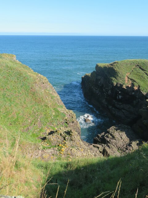
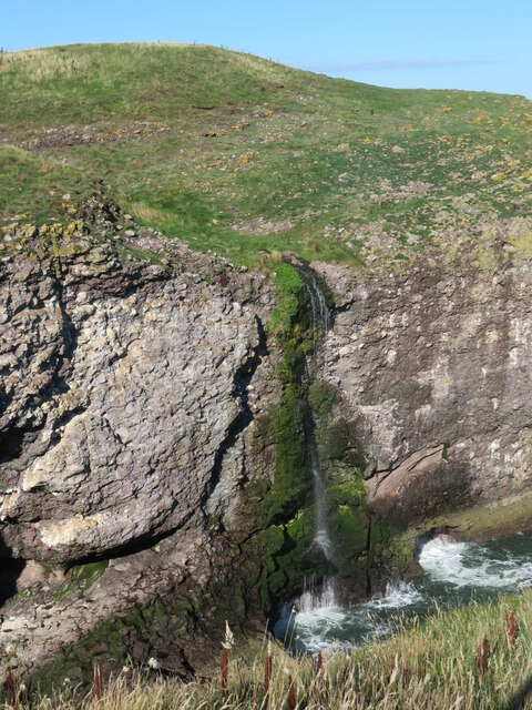
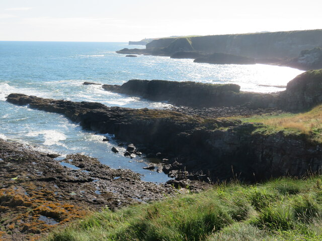
The headland is characterized by its rugged and rocky terrain, rising steeply from the surrounding coastline. The name Hogs Holes is derived from the numerous small caves and crevices found along the shoreline, resembling holes created by wild hogs. These caves are a result of continuous erosion by the powerful waves crashing against the rocks over centuries.

The headland offers breathtaking views of the North Sea, with its towering cliffs and dramatic scenery. It is a popular spot for nature enthusiasts and photographers, who are captivated by the beauty and rawness of the landscape. The area is also home to a diverse range of flora and fauna, including various seabirds that nest on the cliffs.

Hogs Holes is a haven for outdoor activities such as hiking and birdwatching. There are several walking trails that allow visitors to explore the headland and its surroundings, providing opportunities to observe the local wildlife and admire the coastal vistas. The area is also known for its rich marine life, and during low tide, rock pools are exposed, revealing a fascinating world of small marine creatures.

Access to Hogs Holes is relatively easy, with a car park located nearby, providing convenient access for visitors. The headland is a significant landmark in Kincardineshire, attracting both locals and tourists who seek to experience the natural beauty and tranquility of the Scottish coastline.

If you have any feedback on the listing, please let us know in the comments section below.

Hogs Holes Images

Images are sourced within 2km of 56.912458/-2.1969195 or Grid Reference NO8880. Thanks to Geograph Open Source API. All images are credited.

Looking down into Trollochy Trollochy is a short, cliff girt inlet below Crawton.
Looking down into Trollochy
Trollochy is a short, cliff girt inlet below Crawton.
Waterfall into the sea at Crawton A wee burn makes a dramatic plunge into the cliff bound inlet of Trollochy at Crawton.
Waterfall into the sea at Crawton
A wee burn makes a dramatic plunge into the cliff bound inlet of Trollochy at Crawton.
Rock ribs extending out into the sea at Crawton The view south from the small headland at Crawton where rocky reefs defy the waves. The view extends along Crawton Bay.
Rock ribs extending out into the sea at Crawton
The view south from the small headland at Crawton where rocky reefs defy the waves. The view extends along Crawton Bay.
Caravan site, Cloak And cloaked in haar.
Caravan site, Cloak
And cloaked in haar.
A minor road near Catterline You can just see the foglights through the haar. There is a conifer shelter belt on the left, and the trees have thinned the fog enough to get a shot off.
A minor road near Catterline
You can just see the foglights through the haar. There is a conifer shelter belt on the left, and the trees have thinned the fog enough to get a shot off.
Farmland near Mill of Uras
Cotbank of Hilton
Cotbank of Hilton
New house, Cotbank of Hilton
National Cycle Route 1  Heading south near Cotbank of Hilton.
National Cycle Route 1
Heading south near Cotbank of Hilton.
National Cycle Route 1 Heading south.
National Cycle Route 1
Heading south.
Caravan site, Cloak
Caravan site, Cloak
National Cycle Route 1 heading south At Cloak.
National Cycle Route 1 heading south
At Cloak.
Farmland, Mains of Hilton Towards the sea.
Farmland, Mains of Hilton
Towards the sea.
Track to Mains of Hilton Heading east.
Track to Mains of Hilton
Heading east.
St Philip's Church,Catterline  An Episcopal Church .
St Philip's Church,Catterline
An Episcopal Church .
War Memorial, Catterline At St Philip's Church.
War Memorial, Catterline
At St Philip's Church.
National Cycle Route 1 heading south
Farmland near Catterline
Show me another place!

Hogs Holes is located at Grid Ref: NO8880 (Lat: 56.912458, Lng: -2.1969195)

Unitary Authority: Aberdeenshire

Police Authority: North East

What 3 Words

///obey.worms.canoe. Near Stonehaven, Aberdeenshire

Related Wikis

Fowlsheugh

Fowlsheugh is a coastal nature reserve in Kincardineshire, northeast Scotland, known for its 70-metre-high (230 ft) cliff formations and habitat supporting...

Crawton

Crawton is a former fishing community on the southeast Aberdeenshire coast in Scotland, deserted since 1927. Approximately three miles south of Stonehaven...

Craiglethy

Craiglethy (Scottish Gaelic: Creag Liathach - meaning grey rock) is a small island/skerry off Fowlsheugh on the east coast of Aberdeenshire, Scotland in...

Catterline

Catterline is a coastal village on the North Sea in Aberdeenshire, Scotland. It is situated about 5 miles (8.0 km) south of Stonehaven; nearby to the...

Thornyhive Bay

Thornyhive Bay is an embayment along the North Sea coast in Aberdeenshire, Scotland. This bay is situated approximately 2.5 miles south of the town of...

Dunnottar Castle

Dunnottar Castle (Scottish Gaelic: Dùn Fhoithear, "fort on the shelving slope") is a ruined medieval fortress located upon a rocky headland on the north...

Bowdun Head

Bowdun Head is a headland landform on the North Sea coast approximately one kilometre south of Stonehaven, Scotland.(Ordnance Survey, 2004) Slightly to...

Dunnicaer

Dunnicaer, or Dun-na-caer, is a precipitous sea stack just off the coast of Aberdeenshire, Scotland, between Dunnottar Castle and Stonehaven. Despite the...

Nearby Amenities

Located within 500m of 56.912458,-2.1969195
Source: PGS
Lat/Long: 56.9165863/-2.1985334
Source: PGS
Lat/Long: 56.9080123/-2.1977726
Source: PGS
Lat/Long: 56.9086186/-2.1974078
Source: PGS
Lat/Long: 56.9090872/-2.1966541
Created By: almien_coastlines
Source: PGS
Lat/Long: 56.909304/-2.196811
Created By: almien_coastlines
Source: PGS
Lat/Long: 56.909561/-2.197039
Source: PGS
Lat/Long: 56.9095863/-2.1980487
Source: PGS
Lat/Long: 56.9098111/-2.1980964
Source: PGS
Lat/Long: 56.910006/-2.1971759
Source: PGS
Lat/Long: 56.9099871/-2.1968685
Source: PGS
Lat/Long: 56.9102845/-2.1966859
Source: PGS
Lat/Long: 56.9105108/-2.1969399
Source: PGS
Lat/Long: 56.9109397/-2.1971526
Source: PGS
Lat/Long: 56.9112918/-2.1971378
Source: PGS
Lat/Long: 56.9119256/-2.1971802
Source: PGS
Lat/Long: 56.9123284/-2.1969122
Source: PGS
Lat/Long: 56.9134229/-2.1976842
Source: PGS
Lat/Long: 56.9136432/-2.1979993
Source: PGS
Lat/Long: 56.9138388/-2.1982491
Source: PGS
Lat/Long: 56.9140013/-2.1976582
Source: PGS
Lat/Long: 56.9139452/-2.1976461
Source: PGS
Lat/Long: 56.9140066/-2.1973905
Source: PGS
Lat/Long: 56.9149643/-2.1974162
Source: PGS
Lat/Long: 56.9155721/-2.1976839
Source: PGS
Lat/Long: 56.9160347/-2.1980586
Crawton
Is In: Aberdeenshire
Place: locality
Wikidata: Q5183012
Wikipedia: en:Crawton
Lat/Long: 56.9094004/-2.2000668
Waterway: waterfall
Lat/Long: 56.9100157/-2.1977215
Power: pole
Lat/Long: 56.909925/-2.2027976
Power: pole
Lat/Long: 56.9097835/-2.2016895
Power: pole
Lat/Long: 56.9096329/-2.200474
The data included in this document is from www.openstreetmap.org. The data is made available under ODbL.

Have you been to Hogs Holes?

Leave your review of Hogs Holes below (or comments, questions and feedback).