Crawton Ness

Coastal Feature, Headland, Point in Kincardineshire

Scotland

Crawton Ness

Looking down into Trollochy Trollochy is a short, cliff girt inlet below Crawton.
Looking down into Trollochy Credit: Gordon Hatton

Crawton Ness is a prominent coastal feature located in Kincardineshire, Scotland. Situated on the east coast of the country, it is known for its picturesque headland and dramatic cliffs overlooking the North Sea.

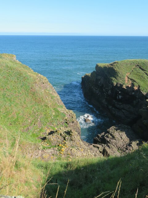
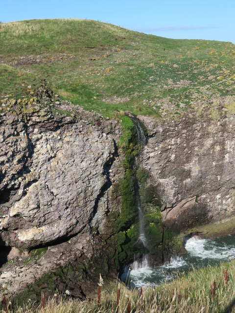
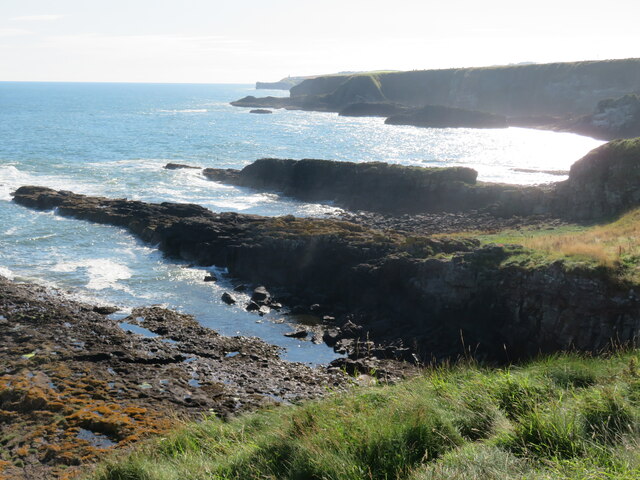
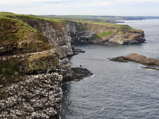
The headland is characterized by its rugged terrain, with steep cliffs rising up to 150 feet in places. These cliffs are composed of layers of sandstone and shale, which have been shaped by centuries of erosion from the relentless waves crashing against the shore. The natural beauty of Crawton Ness is further enhanced by the presence of various rock formations and caves, providing a haven for local wildlife and offering an intriguing sight for visitors.

The headland is also home to a lighthouse, which was built in the 19th century to guide ships navigating the treacherous waters of the North Sea. The lighthouse stands tall at the edge of the headland, offering panoramic views of the surrounding coastline and serving as a beacon of safety for seafarers.

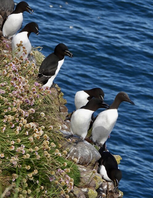
Crawton Ness is a popular destination for nature lovers and outdoor enthusiasts. The area is abundant in wildlife, with numerous bird species nesting on the cliffs and seals often spotted basking on the rocks below. The headland also provides an excellent vantage point for whale and dolphin watching, as these magnificent creatures are known to frequent the nearby waters.

Visitors to Crawton Ness can enjoy walking along the cliff-top paths, taking in the breathtaking views and immersing themselves in the tranquility of this coastal gem. Whether it is for a leisurely stroll, birdwatching, or simply appreciating the raw beauty of nature, Crawton Ness offers a truly unforgettable experience for all who venture there.

If you have any feedback on the listing, please let us know in the comments section below.

Crawton Ness Images

Images are sourced within 2km of 56.910149/-2.1968088 or Grid Reference NO8879. Thanks to Geograph Open Source API. All images are credited.

Looking down into Trollochy Trollochy is a short, cliff girt inlet below Crawton.
Looking down into Trollochy
Trollochy is a short, cliff girt inlet below Crawton.
Waterfall into the sea at Crawton A wee burn makes a dramatic plunge into the cliff bound inlet of Trollochy at Crawton.
Waterfall into the sea at Crawton
A wee burn makes a dramatic plunge into the cliff bound inlet of Trollochy at Crawton.
Rock ribs extending out into the sea at Crawton The view south from the small headland at Crawton where rocky reefs defy the waves. The view extends along Crawton Bay.
Rock ribs extending out into the sea at Crawton
The view south from the small headland at Crawton where rocky reefs defy the waves. The view extends along Crawton Bay.
Baler at work Tractor with baler working a harvested field near Cowieswells Farm.
Baler at work
Tractor with baler working a harvested field near Cowieswells Farm.
Razorbills and Guillemots Lives most of the year at sea, coming to land to breed. Both birds depends on the health of the marine environment. Fishing nets, pollution at sea and declining fish stocks all threaten these birds.
Razorbills and Guillemots
Lives most of the year at sea, coming to land to breed. Both birds depends on the health of the marine environment. Fishing nets, pollution at sea and declining fish stocks all threaten these birds.
Cliffs at Crawley Bird Sanctuary Not so many birds to be seen on the cliff face due to the devastation of Bird flu on the bird population.
Cliffs at Crawley Bird Sanctuary
Not so many birds to be seen on the cliff face due to the devastation of Bird flu on the bird population.
Catterline Burn
Catterline Burn
Caravan site, Cloak And cloaked in haar.
Caravan site, Cloak
And cloaked in haar.
A minor road near Catterline You can just see the foglights through the haar. There is a conifer shelter belt on the left, and the trees have thinned the fog enough to get a shot off.
A minor road near Catterline
You can just see the foglights through the haar. There is a conifer shelter belt on the left, and the trees have thinned the fog enough to get a shot off.
Farmland near Mill of Uras
Cotbank of Hilton
Cotbank of Hilton
New house, Cotbank of Hilton
National Cycle Route 1  Heading south near Cotbank of Hilton.
National Cycle Route 1
Heading south near Cotbank of Hilton.
National Cycle Route 1 Heading south.
National Cycle Route 1
Heading south.
Caravan site, Cloak
Caravan site, Cloak
National Cycle Route 1 heading south At Cloak.
National Cycle Route 1 heading south
At Cloak.
Farmland, Mains of Hilton Towards the sea.
Farmland, Mains of Hilton
Towards the sea.
Track to Mains of Hilton Heading east.
Track to Mains of Hilton
Heading east.
Show me another place!

Crawton Ness is located at Grid Ref: NO8879 (Lat: 56.910149, Lng: -2.1968088)

Unitary Authority: Aberdeenshire

Police Authority: North East

What 3 Words

///meanwhile.scrub.folks. Near Stonehaven, Aberdeenshire

Nearby Locations

Crawton Ness Trollochy

Related Wikis

Crawton

Crawton is a former fishing community on the southeast Aberdeenshire coast in Scotland, deserted since 1927. Approximately three miles south of Stonehaven...

Fowlsheugh

Fowlsheugh is a coastal nature reserve in Kincardineshire, northeast Scotland, known for its 70-metre-high (230 ft) cliff formations and habitat supporting...

Craiglethy

Craiglethy (Scottish Gaelic: Creag Liathach - meaning grey rock) is a small island/skerry off Fowlsheugh on the east coast of Aberdeenshire, Scotland in...

Catterline

Catterline is a coastal village on the North Sea in Aberdeenshire, Scotland. It is situated about 5 miles (8.0 km) south of Stonehaven; nearby to the...

Nearby Amenities

Located within 500m of 56.910149,-2.1968088
Source: PGS
Lat/Long: 56.9078048/-2.2036764
Source: PGS
Lat/Long: 56.90793/-2.2034399
Source: PGS
Lat/Long: 56.9080746/-2.2024374
Source: PGS
Lat/Long: 56.9079956/-2.201975
Source: PGS
Lat/Long: 56.9075657/-2.2018307
Source: PGS
Lat/Long: 56.9075085/-2.2013775
Source: PGS
Lat/Long: 56.9074983/-2.2011763
Source: PGS
Lat/Long: 56.9074895/-2.2002268
Source: PGS
Lat/Long: 56.90722/-2.1998432
Source: PGS
Lat/Long: 56.9068495/-2.1994463
Source: PGS
Lat/Long: 56.9076125/-2.1998271
Source: PGS
Lat/Long: 56.9080123/-2.1977726
Source: PGS
Lat/Long: 56.9086186/-2.1974078
Source: PGS
Lat/Long: 56.9090872/-2.1966541
Created By: almien_coastlines
Source: PGS
Lat/Long: 56.909304/-2.196811
Created By: almien_coastlines
Source: PGS
Lat/Long: 56.909561/-2.197039
Source: PGS
Lat/Long: 56.9095863/-2.1980487
Source: PGS
Lat/Long: 56.9098111/-2.1980964
Source: PGS
Lat/Long: 56.910006/-2.1971759
Source: PGS
Lat/Long: 56.9099871/-2.1968685
Source: PGS
Lat/Long: 56.9102845/-2.1966859
Source: PGS
Lat/Long: 56.9105108/-2.1969399
Source: PGS
Lat/Long: 56.9109397/-2.1971526
Source: PGS
Lat/Long: 56.9112918/-2.1971378
Source: PGS
Lat/Long: 56.9119256/-2.1971802
Source: PGS
Lat/Long: 56.9123284/-2.1969122
Source: PGS
Lat/Long: 56.9134229/-2.1976842
Source: PGS
Lat/Long: 56.9136432/-2.1979993
Source: PGS
Lat/Long: 56.9138388/-2.1982491
Source: PGS
Lat/Long: 56.9140013/-2.1976582
Source: PGS
Lat/Long: 56.9139452/-2.1976461
Source: PGS
Lat/Long: 56.9140066/-2.1973905
Crawton
Is In: Aberdeenshire
Place: locality
Wikidata: Q5183012
Wikipedia: en:Crawton
Lat/Long: 56.9094004/-2.2000668
Waterway: waterfall
Lat/Long: 56.9100157/-2.1977215
Power: pole
Lat/Long: 56.9102021/-2.2050137
Power: pole
Lat/Long: 56.910063/-2.2039035
Power: pole
Lat/Long: 56.909925/-2.2027976
Power: pole
Lat/Long: 56.9097835/-2.2016895
Power: pole
Lat/Long: 56.9096329/-2.200474
The data included in this document is from www.openstreetmap.org. The data is made available under ODbL.

Have you been to Crawton Ness?

Leave your review of Crawton Ness below (or comments, questions and feedback).