Altarstanes

Coastal Feature, Headland, Point in Fife

Scotland

Altarstanes

Simmer Dim at the Low Light, Isle of May The Fife coast extends to Fife Ness in the distance. Mist-nets are erected in the foreground below the old lighthouse for the evening tape-luring of Storm Petrels.
Simmer Dim at the Low Light, Isle of May Credit: Greg Fitchett

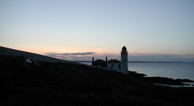
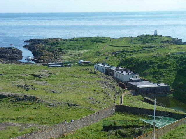
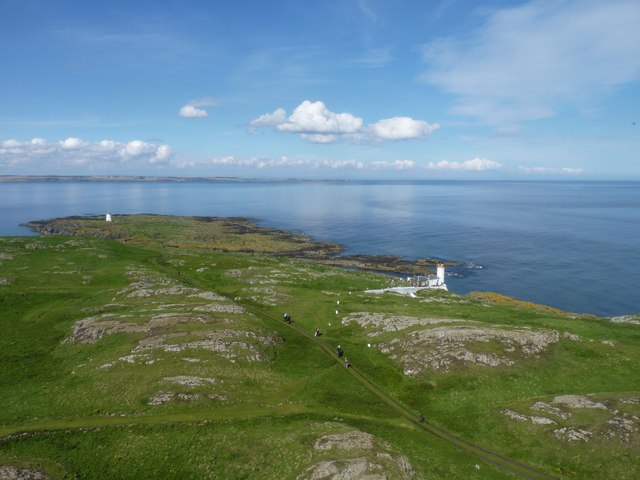
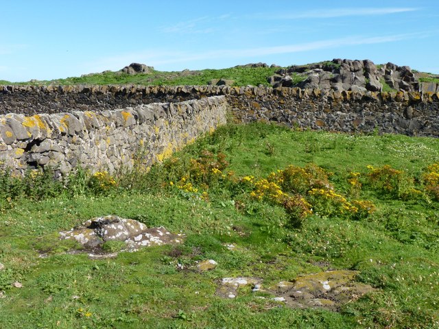
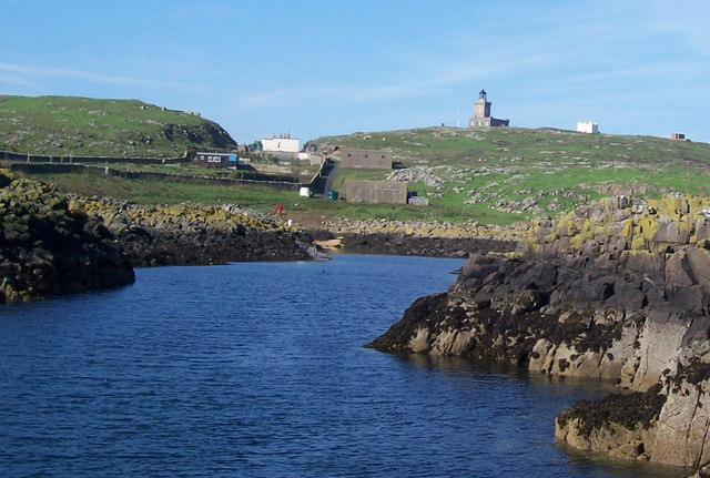
Altarstanes is a prominent coastal feature located in the region of Fife, Scotland. It is characterized as a headland or point, jutting out into the North Sea. The headland is situated approximately 3 miles northeast of the town of St. Andrews, renowned for its historic university and golf courses.

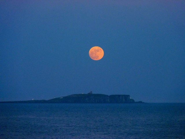
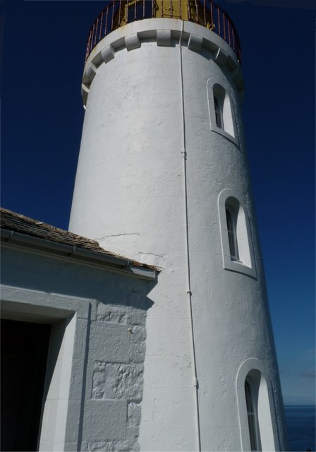
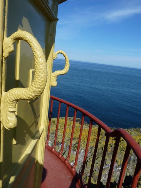
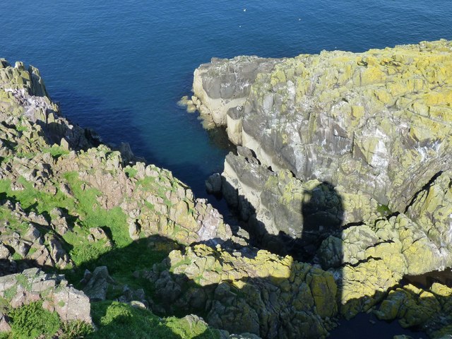
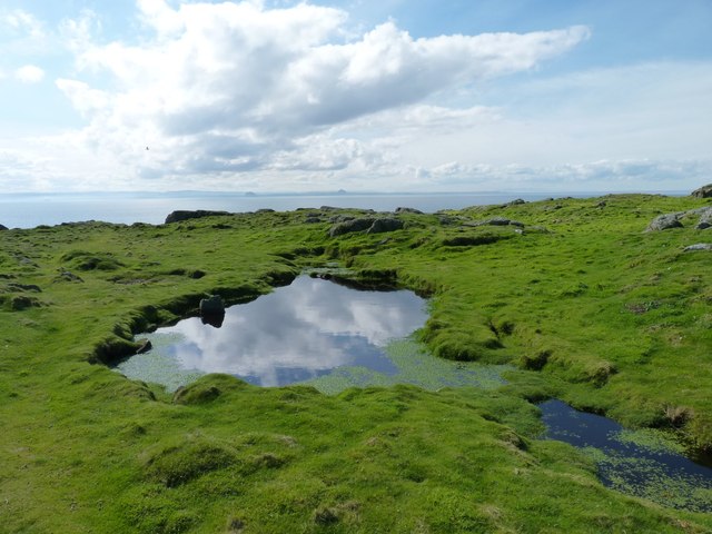
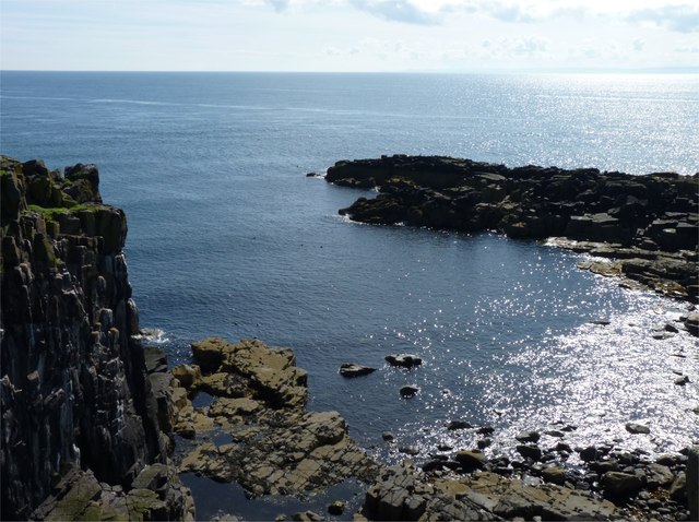
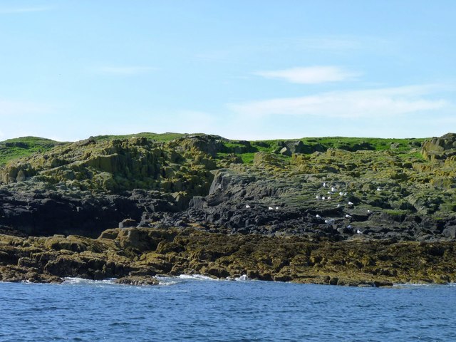
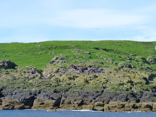
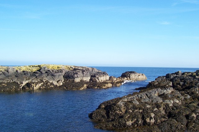
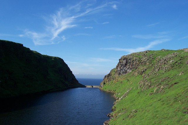
Altarstanes is known for its striking geological formations, which have been shaped by millennia of coastal erosion. The headland is composed of rugged cliffs, rising up to 30 meters in some areas, and offering breathtaking panoramic views of the surrounding coastline. These cliffs are formed from layers of sedimentary rock, displaying a range of colors and textures that add to the area's natural beauty.

The headland is also home to a variety of flora and fauna, making it an important site for biodiversity. Seabirds, including kittiwakes and fulmars, can be observed nesting on the cliffs, while seals and porpoises can sometimes be spotted in the waters below. The headland's vegetation is predominantly grasses and low-lying shrubs, adapted to withstand the harsh coastal conditions.

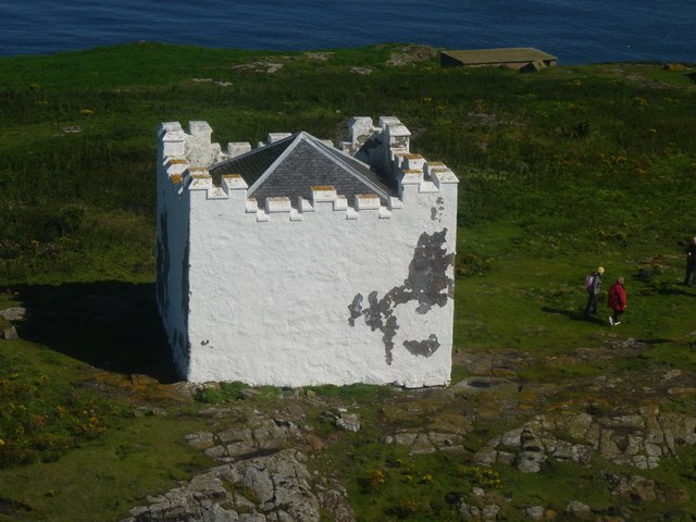
Altarstanes is a popular destination for outdoor enthusiasts and nature lovers. Visitors can explore the headland by following various walking trails, which provide access to the cliff tops and offer stunning views of the North Sea. The area is also frequented by birdwatchers, photographers, and those seeking a peaceful retreat in a picturesque coastal setting.

Overall, Altarstanes in Fife is a captivating coastal feature, offering a combination of striking geological formations, diverse wildlife, and breathtaking views that make it a must-visit destination for nature enthusiasts in the region.

If you have any feedback on the listing, please let us know in the comments section below.

Altarstanes Images

Images are sourced within 2km of 56.188651/-2.5627082 or Grid Reference NT6599. Thanks to Geograph Open Source API. All images are credited.

Simmer Dim at the Low Light, Isle of May The Fife coast extends to Fife Ness in the distance. Mist-nets are erected in the foreground below the old lighthouse for the evening tape-luring of Storm Petrels.
Simmer Dim at the Low Light, Isle of May
The Fife coast extends to Fife Ness in the distance. Mist-nets are erected in the foreground below the old lighthouse for the evening tape-luring of Storm Petrels.
Full moon over the May
Ghostly Footsteps on Isle of May
Looking down on the Beacon The truncated tower of Scotland's oldest lighthouse (the 1636 Beacon) seen from the cupola of the Stevenson-built 1816 Main Light.
Looking down on the Beacon
The truncated tower of Scotland's oldest lighthouse (the 1636 Beacon) seen from the cupola of the Stevenson-built 1816 Main Light.
Fluke Street Looking from the top of the Main Light on the Isle of May towards the buildings in Fluke Street (said to have been so called by naval personnel during WW2, having gained its name from a street in the red-light district of Dundee). The buildings were used to house to fog-horn air compressors and lighthouse personnel. On the left is Kirk Haven, with the ferry from Anstruther moored there and on the right is the white tower of the South Horn.
Fluke Street
Looking from the top of the Main Light on the Isle of May towards the buildings in Fluke Street (said to have been so called by naval personnel during WW2, having gained its name from a street in the red-light district of Dundee). The buildings were used to house to fog-horn air compressors and lighthouse personnel. On the left is Kirk Haven, with the ferry from Anstruther moored there and on the right is the white tower of the South Horn.
Low Light Built in 1844 this light was used by sailors to avoid the Carr Rocks, but was rendered redundant after about 50 years, when a light ship was moored just off the Carr Rocks. The former lighthouse keepers' accommodation is now regularly used by ornithologists.
Low Light
Built in 1844 this light was used by sailors to avoid the Carr Rocks, but was rendered redundant after about 50 years, when a light ship was moored just off the Carr Rocks. The former lighthouse keepers' accommodation is now regularly used by ornithologists.
Grab that serpent Grab handles on the light platform of the Low Light on the Isle of May.
Grab that serpent
Grab handles on the light platform of the Low Light on the Isle of May.
Light casts a shadow The shadow of the Low Light on the Isle of May cast by the sun on the rocks below.
Light casts a shadow
The shadow of the Low Light on the Isle of May cast by the sun on the rocks below.
North end of the island Looking from the top of the Main Light towards the North Horn on the Isle of May. The distant coast is Fife, near Crail, about five miles away.
North end of the island
Looking from the top of the Main Light towards the North Horn on the Isle of May. The distant coast is Fife, near Crail, about five miles away.
Small pond One of the few places where water collects on the Isle of May. The 'lumps' on the far horizon are the Bass Rock in the Firth of Forth and Berwick Law in East Lothian.
Small pond
One of the few places where water collects on the Isle of May. The 'lumps' on the far horizon are the Bass Rock in the Firth of Forth and Berwick Law in East Lothian.
Can you describe a spiral stairway ... ... without using your hands? The ornate stairway leading up the light tower of the Stevenson-built Main Light on the Isle of May, one of the finest examples of the famous builder's work.
Can you describe a spiral stairway ...
... without using your hands? The ornate stairway leading up the light tower of the Stevenson-built Main Light on the Isle of May, one of the finest examples of the famous builder's work.
South extremity The southernmost tip of the Isle of May.
South extremity
The southernmost tip of the Isle of May.
Rocks and stone walls Walls, presumably constructed by inhabitants of the small village that once existed on the island.
Rocks and stone walls
Walls, presumably constructed by inhabitants of the small village that once existed on the island.
Seabirds on the Pillow A rocky promontory just north of the landing place of Kirk Haven.
Seabirds on the Pillow
A rocky promontory just north of the landing place of Kirk Haven.
Wreck of the Island The Danish steamship Island ran aground on the Isle of May in 1937. Those rusty steel ribs are all that remains of her above water level now. Divers can explore more of her remains between 15 and 29 metres deep in the off-shore waters.
Wreck of the Island
The Danish steamship Island ran aground on the Isle of May in 1937. Those rusty steel ribs are all that remains of her above water level now. Divers can explore more of her remains between 15 and 29 metres deep in the off-shore waters.
Isle Of May: Kirkhaven A view of the narrow inlet which the May Princess negotiates to land passengers on the May.
Isle Of May: Kirkhaven
A view of the narrow inlet which the May Princess negotiates to land passengers on the May.
Isle Of May: Approach To Kirkhaven Quay A view of some of the features of the island including the buildings at 'Fluke Street' centre left and the Main Light right of centre.
Isle Of May: Approach To Kirkhaven Quay
A view of some of the features of the island including the buildings at 'Fluke Street' centre left and the Main Light right of centre.
Isle Of May: The Loch A small artificially-created loch can be found near Fluke Street.
Isle Of May: The Loch
A small artificially-created loch can be found near Fluke Street.
Show me another place!

Altarstanes is located at Grid Ref: NT6599 (Lat: 56.188651, Lng: -2.5627082)

Unitary Authority: Fife

Police Authority: Fife

What 3 Words

///inhaled.creamed.postings. Near Crail, Fife

Related Wikis

Isle of May

The Isle of May is located in the north of the outer Firth of Forth, approximately 8 km (5.0 mi) off the coast of mainland Scotland. It is about 1.5 kilometres...

Battle of May Island

The Battle of May Island is the name given to the series of accidents that occurred during Operation E.C.1 in 1918. Named after the Isle of May, a nearby...

Isle of May Priory

The Isle of May Priory was a monastery and community of Benedictine monks established for 9 monks of Reading Abbey on the Isle of May in the Firth of Forth...

SS Sneland I

Sneland I (Norwegian for “snowland one”) was a 1,791 GRT cargo ship which was built by Nüscke & Co. shipyard at Stettin-Grabow (then Germany) in 1922....

Crail Castle

Crail Castle was a castle that was located in Crail, Fife, Scotland. Crail became a Royal Burgh in the 12th century. The castle was frequented by King...

Cellardyke

Cellardyke is a village in the East Neuk of Fife, Scotland. The village is to the immediate east of Anstruther (the two effectively being conjoined) and...

Cellardyke Town Hall

Cellardyke Town Hall is a municipal structure in Tolbooth Wynd, Cellardyke, Fife, Scotland. The building accommodates a local history museum and is also...

Golf Hotel

The Golf Hotel is a hotel and restaurant in Crail, Fife, Scotland. It is a Category A listed building dating to the early 18th century, although one source...

Nearby Amenities

Located within 500m of 56.188651,-2.5627082
Source: PGS
Lat/Long: 56.1846969/-2.5588501
Source: PGS
Lat/Long: 56.1847512/-2.558798
Source: PGS
Lat/Long: 56.1848551/-2.5588246
Source: PGS
Lat/Long: 56.184939/-2.5584593
Created By: almien_coastlines
Source: PGS
Lat/Long: 56.184944/-2.55868
Created By: almien_coastlines
Source: PGS
Lat/Long: 56.185072/-2.558907
Created By: almien_coastlines
Source: PGS
Lat/Long: 56.185332/-2.559822
Created By: almien_coastlines
Source: PGS
Lat/Long: 56.185461/-2.560051
Source: PGS
Lat/Long: 56.1854432/-2.5603639
Source: PGS
Lat/Long: 56.1858189/-2.5607225
Source: PGS
Lat/Long: 56.185977/-2.5610755
Source: PGS
Lat/Long: 56.1859595/-2.5615717
Source: PGS
Lat/Long: 56.186064/-2.5616406
Source: PGS
Lat/Long: 56.1863839/-2.562312
Source: PGS
Lat/Long: 56.1866787/-2.562669
Source: PGS
Lat/Long: 56.1880584/-2.5625904
Source: PGS
Lat/Long: 56.1894377/-2.5636743
Created By: almien_coastlines
Source: PGS
Lat/Long: 56.189568/-2.562759
Source: PGS
Lat/Long: 56.1897005/-2.563052
Source: PGS
Lat/Long: 56.1897802/-2.5632712
Source: PGS
Lat/Long: 56.1902672/-2.564392
Source: PGS
Lat/Long: 56.1904759/-2.5645431
Source: PGS
Lat/Long: 56.1905417/-2.5651428
Source: PGS
Lat/Long: 56.1906097/-2.565356
Source: PGS
Lat/Long: 56.1907888/-2.565587
Source: PGS
Lat/Long: 56.1909424/-2.5660089
Source: PGS
Lat/Long: 56.1912169/-2.5663527
Source: PGS
Lat/Long: 56.1912645/-2.5661591
Source: PGS
Lat/Long: 56.1912636/-2.5665805
Source: PGS
Lat/Long: 56.1913266/-2.5669093
Source: PGS
Lat/Long: 56.1914052/-2.5672306
Source: PGS
Lat/Long: 56.1920137/-2.5668811
Source: PGS
Lat/Long: 56.1919978/-2.5673806
Source: PGS
Lat/Long: 56.1923747/-2.562305
Source: PGS
Lat/Long: 56.1923148/-2.5621355
Source: PGS
Lat/Long: 56.191764/-2.561462
Source: PGS
Lat/Long: 56.1916783/-2.561208
Source: PGS
Lat/Long: 56.1908742/-2.5600243
Source: PGS
Lat/Long: 56.1906005/-2.5597532
Source: PGS
Lat/Long: 56.1904139/-2.5592835
Source: PGS
Lat/Long: 56.1901456/-2.5591051
Source: PGS
Lat/Long: 56.1894614/-2.5598028
Source: PGS
Lat/Long: 56.1895287/-2.5608741
Source: PGS
Lat/Long: 56.1894313/-2.5605868
Source: PGS
Lat/Long: 56.1892048/-2.559022
Source: PGS
Lat/Long: 56.1888545/-2.5588493
Source: PGS
Lat/Long: 56.1887957/-2.5589952
Source: PGS
Lat/Long: 56.1886084/-2.5584359
Source: PGS
Lat/Long: 56.1885226/-2.5583531
Source: PGS
Lat/Long: 56.1884101/-2.5578625
Source: PGS
Lat/Long: 56.1883631/-2.5575001
Source: PGS
Lat/Long: 56.1883696/-2.5570803
Source: PGS
Lat/Long: 56.1883432/-2.5568368
Source: PGS
Lat/Long: 56.1882532/-2.5566018
Source: PGS
Lat/Long: 56.188146/-2.5563226
Source: PGS
Lat/Long: 56.1880078/-2.5561126
Source: PGS
Lat/Long: 56.1881778/-2.5555743
Fog Signal: siren
Lat/Long: 56.1908934/-2.564262
Isle of May Lighthouse
Height: 78
Man Made: lighthouse
Operator: Northern Lighthouse Board
Operator Wikidata: Q918253
Seamark Light Character: Fl
Seamark Light Colour: white
Seamark Light Group: 2
Seamark Light Height: 73
Seamark Light Period: 15
Seamark Light Range: 22
Seamark Light Reference: A 3090
Seamark Light Sequence: 0.3+(1.6)+0.3+(12.8)
Seamark Type: light_major
Source: US NGA Pub. 114. 2011-05-26.
Website: https://www.nlb.org.uk/lighthouses/isle-of-may/
Wikidata: Q17817380
Wikipedia: en:Isle of May Lighthouse
Lat/Long: 56.1856454/-2.5574451
Disused Man Made: lighthouse
Old Name: Low Light
Lat/Long: 56.1877826/-2.5574791
Altarstanes
Tourism: viewpoint
Lat/Long: 56.1888355/-2.5624092
Bench
Backrest: yes
Lat/Long: 56.1856491/-2.5576067
The Low Light
Information: board
Tourism: information
Lat/Long: 56.1872521/-2.557758
The Main Light
Information: board
Tourism: information
Lat/Long: 56.1855572/-2.5570639
Bishop's Cove
Tourism: viewpoint
Lat/Long: 56.1860309/-2.5614597
The data included in this document is from www.openstreetmap.org. The data is made available under ODbL.

Have you been to Altarstanes?

Leave your review of Altarstanes below (or comments, questions and feedback).