Geodha nan Sliseag
Coastal Feature, Headland, Point in Argyllshire
Scotland
Geodha nan Sliseag

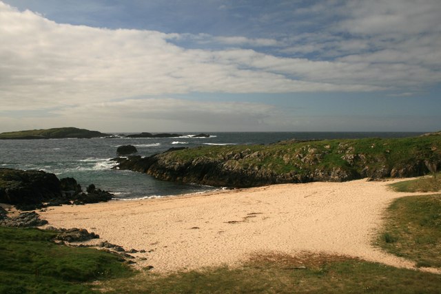
Geodha nan Sliseag, located in Argyllshire, Scotland, is a stunning coastal feature that attracts visitors with its breathtaking natural beauty. This headland, also known as Sliseag Point, is situated on the west coast of Scotland, overlooking the expansive Atlantic Ocean.
Geodha nan Sliseag is characterized by its rugged landscape and dramatic cliffs that soar above the crashing waves below. The headland offers panoramic views of the surrounding seascape, including distant islands and the majestic mountains of the Scottish Highlands. The area is a haven for nature enthusiasts and photographers, who flock here to capture the raw beauty of the Scottish coastline.
The headland is also home to a diverse range of flora and fauna. The cliffs provide nesting sites for various seabirds, including guillemots, puffins, and razorbills. Visitors can often spot these fascinating creatures soaring above the ocean or perched on the rocky ledges. The coastal waters surrounding Geodha nan Sliseag are also teeming with marine life, making it an ideal spot for fishing and wildlife observation.
Access to Geodha nan Sliseag is primarily via a coastal path that winds its way along the cliff edge. The path offers breathtaking views at every turn, but caution is advised as it can be steep and exposed in places. Visitors are also recommended to check the tide times before visiting, as some areas of the headland may become inaccessible during high tide.
Geodha nan Sliseag is a true gem on Scotland's west coast, offering visitors a chance to immerse themselves in the raw beauty of the Scottish coastline and experience the untamed power of the Atlantic Ocean.
If you have any feedback on the listing, please let us know in the comments section below.
Geodha nan Sliseag Images
Images are sourced within 2km of 55.69255/-6.5239034 or Grid Reference NR1553. Thanks to Geograph Open Source API. All images are credited.


Geodha nan Sliseag is located at Grid Ref: NR1553 (Lat: 55.69255, Lng: -6.5239034)
Unitary Authority: Argyll and Bute
Police Authority: Argyll and West Dunbartonshire
What 3 Words
///airstrip.warbler.slams. Near Portnahaven, Argyll & Bute
Nearby Locations
Related Wikis

Islay LIMPET
Islay LIMPET was the world's first commercial wave power device and was connected to the United Kingdom's National Grid. == History == Islay LIMPET (Land...

Eilean Mhic Coinnich
Eilean Mhic Coinnich, also known as Mackenzie Island (although recorded on the Land Register as McKenseys Island), is an uninhabited island of 17.3 hectares...

Portnahaven
Portnahaven (Scottish Gaelic: Port na h-Abhainne, meaning river port) is a village on Islay in the Inner Hebrides, Scotland. The village is within the...

Orsay, Inner Hebrides
Orsay (Scottish Gaelic: Orasaigh) is a small island in the Inner Hebrides of Scotland. It lies a short distance off the west coast of the island of Islay...

Rhinns complex
The Rhinns complex is a deformed Palaeoproterozoic igneous complex that is considered to form the basement to the Colonsay Group of metasedimentary rocks...

Easter Ellister
Easter Ellister (Aolastradh) is a settlement on the Rinns of Islay on Islay in the Inner Hebrides of Scotland. It lies just off the A847 road between Portnahaven...

Nerabus
Nerabus (otherwise Nereabolls) is a hamlet in the west of the isle of Islay in Scotland. The vicinity is noted for its scenic qualities and diverse birdlife...

Rinns of Islay
The Rinns of Islay (Scottish Gaelic: Na Roinn Ìleach; alternative English spelling Rhinns of Islay) is an area on the west of the island of Islay in the...
Nearby Amenities
Located within 500m of 55.69255,-6.5239034Have you been to Geodha nan Sliseag?
Leave your review of Geodha nan Sliseag below (or comments, questions and feedback).