Druim a Chruidh
Coastal Feature, Headland, Point in Ross-shire
Scotland
Druim a Chruidh

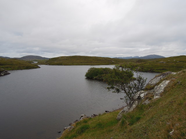
Druim a Chruidh is a prominent coastal feature located in Ross-shire, Scotland. It is a headland or point that juts out into the North Atlantic Ocean, offering breathtaking views and natural beauty. The name Druim a Chruidh translates to "ridge of the cattle" in Gaelic, hinting at the area's historical association with farming and agriculture.
Situated on the northwest coast of Scotland, Druim a Chruidh is characterized by its rugged cliffs, rocky terrain, and stunning vistas of the sea. The headland is formed by layers of sedimentary rocks, which have been shaped over centuries by the relentless force of the crashing waves. These geological formations create a dramatic backdrop that is a haven for photographers, nature enthusiasts, and hikers alike.
The headland is also home to a diverse range of flora and fauna. The cliffs provide nesting sites for various seabird species, including puffins, guillemots, and razorbills. Visitors may spot seals and dolphins swimming in the waters surrounding Druim a Chruidh, adding to the area's allure.
Access to Druim a Chruidh is relatively straightforward, with a well-defined path that leads to the headland. While the terrain can be challenging, it rewards visitors with awe-inspiring views and a sense of tranquility. The location is a popular spot for walking, birdwatching, and picnicking, allowing visitors to immerse themselves in the natural splendor of the Scottish coast.
Overall, Druim a Chruidh is a captivating coastal feature that showcases the rugged beauty of the Scottish landscape. Its geological formations, diverse wildlife, and breathtaking views make it an enchanting destination for nature lovers and adventurers alike.
If you have any feedback on the listing, please let us know in the comments section below.
Druim a Chruidh Images
Images are sourced within 2km of 58.207307/-6.8414379 or Grid Reference NB1534. Thanks to Geograph Open Source API. All images are credited.


Druim a Chruidh is located at Grid Ref: NB1534 (Lat: 58.207307, Lng: -6.8414379)
Unitary Authority: Na h-Eileanan an Iar
Police Authority: Highlands and Islands
What 3 Words
///payback.twists.chuckling. Near Carloway, Na h-Eileanan Siar
Related Wikis

Callanish VIII
The Callanish VIII stone setting is one of many megalithic structures around the better-known (and larger) Calanais I on the west coast of the Isle of...

Dun Bharabhat, Great Bernera
Dun Bharabhat (or Dun Baravat) is an Iron Age galleried dun or "semi-broch" situated on the island of Great Bernera near Lewis in Scotland (grid reference...

Breaclete
Breacleit (or Roulanish; Scottish Gaelic: Breacleit; Old Norse: Breiðiklettr) is the central village on Great Bernera in the Outer Hebrides, Scotland....

Great Bernera
Great Bernera (; Scottish Gaelic: Beàrnaraigh Mòr), often known just as Bernera (Scottish Gaelic: Beàrnaraigh), is an island and community in the Outer...
Related Videos
Great Bernera, Iron Age House
Great Bernera, Iron Age House, Bosta Beach. Outer Hebrides, Scotland.

The Isle of Great Bernera
Great Bernera is a small island off the coast of a bigger island, the isle of Lewis. Recently, I've been staying on the isle of Lewis ...

A Hebridean Odyssey: Part 15 - Lewis: Great Bernera
This video is the fifteenth in a series that documents a trip taken in May 2022, in which we visited 16 of the Hebridean islands.

Island Of Great Bernera On History Visit To The Outer Hebrides Of Scotland
Tour Scotland short travel video clip, with Scottish music, of the Island Of Great Bernera on ancestry, genealogy, history visit to the ...
Nearby Amenities
Located within 500m of 58.207307,-6.8414379Have you been to Druim a Chruidh?
Leave your review of Druim a Chruidh below (or comments, questions and feedback).