Aonaig Ruadh Tamna Sear
Coastal Feature, Headland, Point in Ross-shire
Scotland
Aonaig Ruadh Tamna Sear

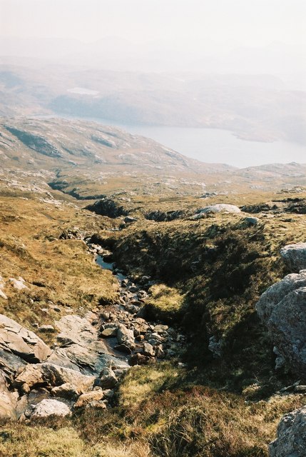
Aonaig Ruadh Tamna Sear is a prominent coastal feature located in Ross-shire, Scotland. It is categorized as a headland or point, jutting out into the sea and forming a distinctive landform along the coastline. The name "Aonaig Ruadh Tamna Sear" is derived from Scottish Gaelic, with "Aonaig Ruadh" meaning "red sand dunes" and "Tamna Sear" referring to the eastern part of the headland.
This coastal feature is characterized by its rugged, rocky terrain, which is interspersed with patches of red sand dunes. The headland overlooks the vast expanse of the North Sea, providing breathtaking panoramic views of the surrounding coastal landscape. Aonaig Ruadh Tamna Sear is also known for its rich biodiversity, with various species of seabirds, marine mammals, and plant life inhabiting the area.
The headland offers a range of recreational activities for visitors. Hiking trails wind their way through the headland, allowing nature enthusiasts to explore the diverse flora and fauna. Additionally, the rocky cliffs provide opportunities for rock climbing and birdwatching. The headland is easily accessible by road, with a designated parking area nearby.
Aonaig Ruadh Tamna Sear is not only a scenic coastal feature but also holds historical significance. It is believed to have been a strategic point during ancient times, with remnants of ancient forts and settlements discovered in the vicinity. Archaeological excavations have unearthed artifacts and structures that shed light on the area's past.
Overall, Aonaig Ruadh Tamna Sear is a captivating headland in Ross-shire, offering spectacular views, recreational activities, and a window into Scotland's rich history and natural beauty.
If you have any feedback on the listing, please let us know in the comments section below.
Aonaig Ruadh Tamna Sear Images
Images are sourced within 2km of 58.063589/-7.0659832 or Grid Reference NB0119. Thanks to Geograph Open Source API. All images are credited.


Aonaig Ruadh Tamna Sear is located at Grid Ref: NB0119 (Lat: 58.063589, Lng: -7.0659832)
Unitary Authority: Na h-Eileanan an Iar
Police Authority: Highlands and Islands
What 3 Words
///probe.winter.prune. Near Tarbert, Na h-Eileanan Siar
Related Wikis

Eilean Mhealasta
Eilean Mhealasta (Mealista Island) is an uninhabited island off the west coast of Lewis in the Outer Hebrides of Scotland. It takes its name from Mealista...

Game pieces of the Lewis chessmen hoard
Game pieces of the Lewis chessmen hoard include the ninety-three game pieces of the Lewis chessmen hoard found on the Isle of Lewis in the Outer Hebrides...

Mealista
Mealista (Scottish Gaelic: Mealasta) was a township in the west of the Isle of Lewis. It is currently largely uninhabited due to the Highland Clearances...

Scarp, Scotland
Scarp (Scottish Gaelic: An Sgarp) is an uninhabited island in the Outer Hebrides of Scotland, west of Hushinish on Harris. Once inhabited, the island was...

Brenish
Brenish (Scottish Gaelic: Brèinis) is a small village situated on the west coast of the Isle of Lewis, which is part of the Outer Hebrides of Scotland...

Hushinish
Huisinish or Hushinish (Scottish Gaelic Hùisinis) is a remote place on the west coast of Harris in the Outer Hebrides of Scotland. It lies at the end of...

Tiorga Mor
Tiorga Mor (679 m) is a mountain in Harris, in the Outer Hebrides of Scotland. The most westerly peak of the high mountains of Harris, it is a very rugged...

Uladail
Uladail is a location near Amhuinnsuidhe, on Harris in the Outer Hebrides, Scotland. Sron Ulladail is a sheer cliff which at 370 metres (1,210 ft) is one...
Nearby Amenities
Located within 500m of 58.063589,-7.0659832Have you been to Aonaig Ruadh Tamna Sear?
Leave your review of Aonaig Ruadh Tamna Sear below (or comments, questions and feedback).