Loch na Bà

Lake, Pool, Pond, Freshwater Marsh in Ross-shire

Scotland

Loch na Bà

Wild camp at the head of Tamana Siar
Wild camp at the head of Tamana Siar Credit: Peter Edwards

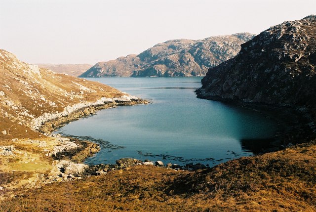
Loch na Bà is a picturesque freshwater loch located in Ross-shire, Scotland. Nestled amidst the striking landscape of the Scottish Highlands, it is a popular tourist destination known for its natural beauty and tranquility.

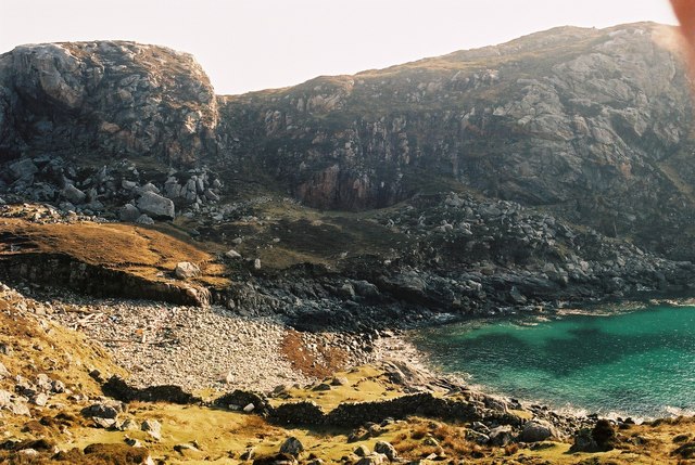
The loch spans an area of approximately 2 square kilometers, with a maximum depth of around 25 meters. Surrounded by rolling hills and heather-covered moorlands, it offers stunning panoramic views and a sense of peaceful seclusion.

Loch na Bà is home to a diverse range of flora and fauna, making it an important ecological site. The loch supports a variety of aquatic plants, including water lilies, reeds, and submerged vegetation, which provide habitat and food sources for numerous species of fish and invertebrates. Birdwatchers are often drawn to the area due to the presence of various waterfowl, such as swans, ducks, and herons, which can be spotted along the shoreline or gliding across the calm waters.

The loch also offers recreational activities for visitors. Fishing enthusiasts can try their luck at catching brown trout, which are abundant in the loch. Canoeing and kayaking are popular water sports, allowing visitors to explore the serene surroundings at their own pace.

Loch na Bà is easily accessible, with a car park and a nearby walking trail that offers breathtaking views of the loch and surrounding landscape. Whether it is for a leisurely walk, a peaceful picnic, or to immerse oneself in the beauty of the Scottish Highlands, Loch na Bà is a must-visit destination for nature lovers and those seeking a tranquil escape.

If you have any feedback on the listing, please let us know in the comments section below.

Loch na Bà Images

Images are sourced within 2km of 58.063464/-7.0695814 or Grid Reference NB0119. Thanks to Geograph Open Source API. All images are credited.

Wild camp at the head of Tamana Siar
Mullach na h-Airde Bige Second HuMP around the northern edge of Loch Resort on an Alan Holmes RIB trip. What a brilliant day.
Name: Mullach na h-Airde Bige
Hill number: 4947
Height: 182m / 597ft
Area: 24A: Lewis and Nearby Islands
Class: Hu,1
Grid ref: NB026188 (est)
Drop: 128m
Col: 54m  NB044194
Mullach na h-Airde Bige
Second HuMP around the northern edge of Loch Resort on an Alan Holmes RIB trip. What a brilliant day. Name: Mullach na h-Airde Bige Hill number: 4947 Height: 182m / 597ft Area: 24A: Lewis and Nearby Islands Class: Hu,1 Grid ref: NB026188 (est) Drop: 128m Col: 54m NB044194
Rubha Loisgte An abruptly truncated spur of rock meets the sea.
Rubha Loisgte
An abruptly truncated spur of rock meets the sea.
Rubha Geodha nan Sgarbh The entrance to Loch Tealasvay is well concealed close to the right of the picture.
Rubha Geodha nan Sgarbh
The entrance to Loch Tealasvay is well concealed close to the right of the picture.
View to Scarp from the Island of Liongam
View of the Lewis mainland to Mealasta Island from the Island of Liongam
View from the Island of Liongam to the North Harris Hills
Looking South over the lochan to Scarp and beyond from the Island of Liongam
Looking East to the Lewis mainland from the Island of Liongam
The Rocky South East Shore of the Island of Liongam with a view of the North Harris Hills
A Craggy Cove on the East Coast of the Island of Liongam
A View looking South over the Island of Liongam to Scarp, the North Harris Hills and Taransay beyond
Loch Tamnabhaigh Aird Bheag to left of image and Tamana Sear to right
Loch Tamnabhaigh
Aird Bheag to left of image and Tamana Sear to right
Gleann Sgaladail burn meets Loch Tamnabhaigh
Moorland above Loch Tamnabhaigh
Mocleitean from Aird Bheag with Eilean Mhealasta in the background
Tamana Sear
Tamana Sear
Tamana Siar
Tamana Siar
Show me another place!

Loch na Bà is located at Grid Ref: NB0119 (Lat: 58.063464, Lng: -7.0695814)

Unitary Authority: Na h-Eileanan an Iar

Police Authority: Highlands and Islands

What 3 Words

///plea.additives.voters. Near Tarbert, Na h-Eileanan Siar

Related Wikis

Eilean Mhealasta

Eilean Mhealasta (Mealista Island) is an uninhabited island off the west coast of Lewis in the Outer Hebrides of Scotland. It takes its name from Mealista...

Game pieces of the Lewis chessmen hoard

Game pieces of the Lewis chessmen hoard include the ninety-three game pieces of the Lewis chessmen hoard found on the Isle of Lewis in the Outer Hebrides...

Mealista

Mealista (Scottish Gaelic: Mealasta) was a township in the west of the Isle of Lewis. It is currently largely uninhabited due to the Highland Clearances...

Scarp, Scotland

Scarp (Scottish Gaelic: An Sgarp) is an uninhabited island in the Outer Hebrides of Scotland, west of Hushinish on Harris. Once inhabited, the island was...

Nearby Amenities

Located within 500m of 58.063464,-7.0695814
Tamna Sear
Natural: bay
Lat/Long: 58.0662253/-7.0682989
Aird Mhor Mill Tamna
Place: locality
Lat/Long: 58.0628331/-7.0650613
Aonaig Ruadh Tamna Sear
Place: locality
Lat/Long: 58.0643427/-7.0657694
Gearraaidh Mill Tamna
Place: locality
Lat/Long: 58.0670229/-7.0741031
The data included in this document is from www.openstreetmap.org. The data is made available under ODbL.

Have you been to Loch na Bà?

Leave your review of Loch na Bà below (or comments, questions and feedback).