Cnoc na Shinas

Hill, Mountain in Ross-shire

Scotland

Cnoc na Shinas

Wild camp at the head of Tamana Siar
Wild camp at the head of Tamana Siar Credit: Peter Edwards

Cnoc na Shinas is a prominent hill located in Ross-shire, Scotland. Standing at an elevation of approximately 518 meters (1,699 feet), it offers stunning panoramic views of the surrounding landscapes. The hill is situated near the village of Aultbea and lies within the spectacular Northwest Highlands region.

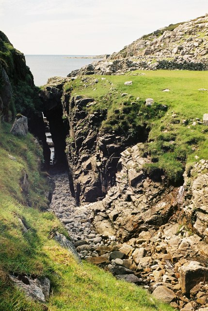
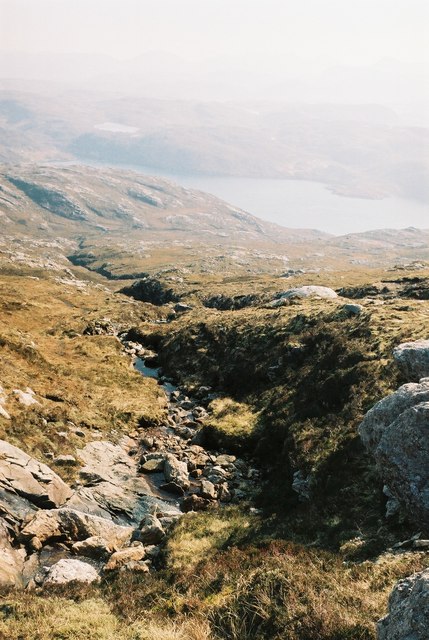
The terrain of Cnoc na Shinas primarily consists of heather-covered moorland, rocky outcrops, and scattered patches of woodland. The slopes of the hill are steep in places, making it a moderate to challenging climb for hikers and outdoor enthusiasts. However, the effort is rewarded with breathtaking vistas of the surrounding mountains, lochs, and the nearby coastline.

The summit of Cnoc na Shinas provides an excellent vantage point to admire the picturesque vistas of Loch Ewe, Loch Maree, and the Torridon mountains. On a clear day, one can even catch a glimpse of the Isle of Skye in the distance. The hill is also home to a diverse range of flora and fauna, including red deer, golden eagles, and various species of wildflowers.

Access to Cnoc na Shinas is relatively straightforward, with several well-marked trails leading to the summit. The hill can be traversed in approximately 2-3 hours, depending on the chosen route and individual fitness levels. It is advisable to wear appropriate hiking gear and carry essentials such as food, water, and a map when exploring the area.

Overall, Cnoc na Shinas offers a rewarding outdoor experience for nature lovers and those seeking to immerse themselves in the rugged beauty of the Scottish Highlands.

If you have any feedback on the listing, please let us know in the comments section below.

Cnoc na Shinas Images

Images are sourced within 2km of 58.066013/-7.0708603 or Grid Reference NB0119. Thanks to Geograph Open Source API. All images are credited.

Wild camp at the head of Tamana Siar
Moorland opposite Eilean Mhealasta
Mullach na h-Airde Bige Second HuMP around the northern edge of Loch Resort on an Alan Holmes RIB trip. What a brilliant day.
Name: Mullach na h-Airde Bige
Hill number: 4947
Height: 182m / 597ft
Area: 24A: Lewis and Nearby Islands
Class: Hu,1
Grid ref: NB026188 (est)
Drop: 128m
Col: 54m  NB044194
Mullach na h-Airde Bige
Second HuMP around the northern edge of Loch Resort on an Alan Holmes RIB trip. What a brilliant day. Name: Mullach na h-Airde Bige Hill number: 4947 Height: 182m / 597ft Area: 24A: Lewis and Nearby Islands Class: Hu,1 Grid ref: NB026188 (est) Drop: 128m Col: 54m NB044194
Rubha Loisgte An abruptly truncated spur of rock meets the sea.
Rubha Loisgte
An abruptly truncated spur of rock meets the sea.
Rubha Geodha nan Sgarbh The entrance to Loch Tealasvay is well concealed close to the right of the picture.
Rubha Geodha nan Sgarbh
The entrance to Loch Tealasvay is well concealed close to the right of the picture.
View to Scarp from the Island of Liongam
View of the Lewis mainland to Mealasta Island from the Island of Liongam
View from the Island of Liongam to the North Harris Hills
Looking South over the lochan to Scarp and beyond from the Island of Liongam
Looking East to the Lewis mainland from the Island of Liongam
The Rocky South East Shore of the Island of Liongam with a view of the North Harris Hills
A Craggy Cove on the East Coast of the Island of Liongam
A View looking South over the Island of Liongam to Scarp, the North Harris Hills and Taransay beyond
Loch Tamnabhaigh Aird Bheag to left of image and Tamana Sear to right
Loch Tamnabhaigh
Aird Bheag to left of image and Tamana Sear to right
Gully Between Aird Ghriamanais and Aird Dhrolai geodha.
Gully
Between Aird Ghriamanais and Aird Dhrolai geodha.
Burn flowing into Gleann Sgaladail
The head of Gleann Sgaladail The lower picture shows ruined shielings with a burn running through.
The head of Gleann Sgaladail
The lower picture shows ruined shielings with a burn running through.
Ruined shielings in Gleann Sgaladail
Show me another place!

Cnoc na Shinas is located at Grid Ref: NB0119 (Lat: 58.066013, Lng: -7.0708603)

Unitary Authority: Na h-Eileanan an Iar

Police Authority: Highlands and Islands

What 3 Words

///extremely.animals.focal. Near Tarbert, Na h-Eileanan Siar

Related Wikis

Eilean Mhealasta

Eilean Mhealasta (Mealista Island) is an uninhabited island off the west coast of Lewis in the Outer Hebrides of Scotland. It takes its name from Mealista...

Game pieces of the Lewis chessmen hoard

Game pieces of the Lewis chessmen hoard include the ninety-three game pieces of the Lewis chessmen hoard found on the Isle of Lewis in the Outer Hebrides...

Mealista

Mealista (Scottish Gaelic: Mealasta) was a township in the west of the Isle of Lewis. It is currently largely uninhabited due to the Highland Clearances...

Scarp, Scotland

Scarp (Scottish Gaelic: An Sgarp) is an uninhabited island in the Outer Hebrides of Scotland, west of Hushinish on Harris. Once inhabited, the island was...

Nearby Amenities

Located within 500m of 58.066013,-7.0708603
Tamna Sear
Natural: bay
Lat/Long: 58.0662253/-7.0682989
Aird Mhor Mill Tamna
Place: locality
Lat/Long: 58.0628331/-7.0650613
Aonaig Ruadh Tamna Sear
Place: locality
Lat/Long: 58.0643427/-7.0657694
Gearraaidh Mill Tamna
Place: locality
Lat/Long: 58.0670229/-7.0741031
The data included in this document is from www.openstreetmap.org. The data is made available under ODbL.

Have you been to Cnoc na Shinas?

Leave your review of Cnoc na Shinas below (or comments, questions and feedback).