Gearraidh Mill Tamna
Downs, Moorland in Ross-shire
Scotland
Gearraidh Mill Tamna

Gearraidh Mill Tamna is a small hamlet located in the region of Ross-shire, Scotland. Situated amidst the beautiful landscape, it is primarily known for its downs and moorland, which provide a picturesque setting for outdoor enthusiasts and nature lovers.
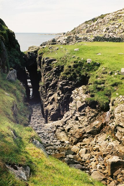
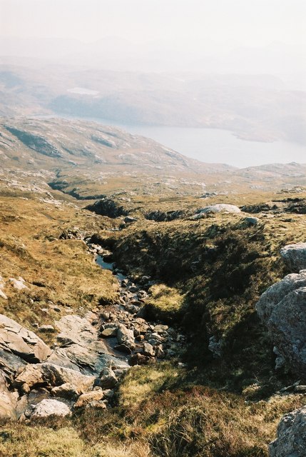
The downs of Gearraidh Mill Tamna offer vast stretches of rolling hills covered in lush green grass. This terrain is ideal for activities such as hiking, picnicking, and leisurely walks, allowing visitors to immerse themselves in the tranquility of the countryside. The undulating landscape also provides a perfect opportunity for photography enthusiasts to capture stunning panoramic views.
In addition to the downs, Gearraidh Mill Tamna is surrounded by vast expanses of moorland. These areas are characterized by their distinctive vegetation, including heather and bog myrtle, which add a splash of color to the landscape. The moorland is also home to a variety of wildlife, such as red deer, grouse, and various bird species, making it a popular spot for birdwatching and wildlife observation.
Despite its small size, Gearraidh Mill Tamna offers a few amenities for visitors. There are a couple of charming bed and breakfast accommodations, as well as a local pub where visitors can enjoy traditional Scottish hospitality and cuisine.
Overall, Gearraidh Mill Tamna is a hidden gem in Ross-shire, offering a tranquil escape surrounded by downs and moorland. Whether it's exploring the beautiful landscape, observing wildlife, or simply enjoying the peace and serenity of the countryside, this hamlet provides a unique and memorable experience for all who visit.
If you have any feedback on the listing, please let us know in the comments section below.
Gearraidh Mill Tamna Images
Images are sourced within 2km of 58.06702/-7.0711053 or Grid Reference NB0119. Thanks to Geograph Open Source API. All images are credited.


Gearraidh Mill Tamna is located at Grid Ref: NB0119 (Lat: 58.06702, Lng: -7.0711053)
Unitary Authority: Na h-Eileanan an Iar
Police Authority: Highlands and Islands
What 3 Words
///dabbling.balloons.coherent. Near Tarbert, Na h-Eileanan Siar
Related Wikis

Eilean Mhealasta
Eilean Mhealasta (Mealista Island) is an uninhabited island off the west coast of Lewis in the Outer Hebrides of Scotland. It takes its name from Mealista...

Game pieces of the Lewis chessmen hoard
Game pieces of the Lewis chessmen hoard include the ninety-three game pieces of the Lewis chessmen hoard found on the Isle of Lewis in the Outer Hebrides...

Mealista
Mealista (Scottish Gaelic: Mealasta) was a township in the west of the Isle of Lewis. It is currently largely uninhabited due to the Highland Clearances...

Scarp, Scotland
Scarp (Scottish Gaelic: An Sgarp) is an uninhabited island in the Outer Hebrides of Scotland, west of Hushinish on Harris. Once inhabited, the island was...

Brenish
Brenish (Scottish Gaelic: Brèinis) is a small village situated on the west coast of the Isle of Lewis, which is part of the Outer Hebrides of Scotland...

Hushinish
Huisinish or Hushinish (Scottish Gaelic Hùisinis) is a remote place on the west coast of Harris in the Outer Hebrides of Scotland. It lies at the end of...

Tiorga Mor
Tiorga Mor (679 m) is a mountain in Harris, in the Outer Hebrides of Scotland. The most westerly peak of the high mountains of Harris, it is a very rugged...

Uladail
Uladail is a location near Amhuinnsuidhe, on Harris in the Outer Hebrides, Scotland. Sron Ulladail is a sheer cliff which at 370 metres (1,210 ft) is one...
Nearby Amenities
Located within 500m of 58.06702,-7.0711053Have you been to Gearraidh Mill Tamna?
Leave your review of Gearraidh Mill Tamna below (or comments, questions and feedback).