Geodha Sgridleich

Coastal Feature, Headland, Point in Ross-shire

Scotland

Geodha Sgridleich

Wild camp at the head of Tamana Siar
Wild camp at the head of Tamana Siar Credit: Peter Edwards

Geodha Sgridleich is a prominent coastal feature located in Ross-shire, Scotland. It is classified as a headland or point due to its distinctive protrusion into the sea. The name "Geodha Sgridleich" is derived from Gaelic, with "geodha" meaning "cove" and "sgridleich" referring to the specific location.

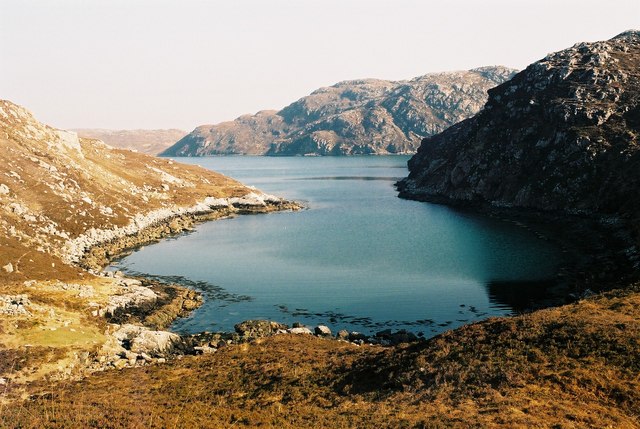
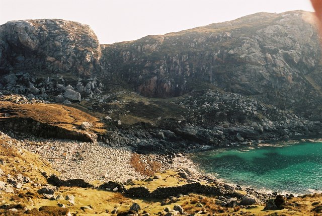
Situated along the rugged coastline, Geodha Sgridleich offers breathtaking views of the surrounding landscape. The headland is characterized by towering cliffs that jut out into the North Atlantic Ocean, creating a dramatic and picturesque scene. The cliffs have been eroded over time, resulting in unique rock formations and caves that add to the area's allure.

Geodha Sgridleich is renowned for its rich biodiversity and serves as an important habitat for various marine species. The nutrient-rich waters support a diverse ecosystem, attracting a wide range of marine life, including seabirds, seals, and even dolphins. The headland is also a popular spot for birdwatching enthusiasts, who can observe species such as puffins and gannets nesting along the cliffs.

The coastal feature is easily accessible to visitors, with several walking trails and viewpoints available. These paths offer stunning vistas of the sea and the surrounding coastline, making it a favorite spot for nature lovers and photographers. Geodha Sgridleich is also a popular destination for outdoor activities such as hiking, rock climbing, and fishing.

In conclusion, Geodha Sgridleich is a striking headland located in Ross-shire, Scotland. Its rugged cliffs, diverse wildlife, and breathtaking views make it a must-visit destination for those seeking to explore the region's coastal beauty.

If you have any feedback on the listing, please let us know in the comments section below.

Geodha Sgridleich Images

Images are sourced within 2km of 58.05966/-7.0571247 or Grid Reference NB0119. Thanks to Geograph Open Source API. All images are credited.

Wild camp at the head of Tamana Siar
Mullach na h-Airde Bige Second HuMP around the northern edge of Loch Resort on an Alan Holmes RIB trip. What a brilliant day.
Name: Mullach na h-Airde Bige
Hill number: 4947
Height: 182m / 597ft
Area: 24A: Lewis and Nearby Islands
Class: Hu,1
Grid ref: NB026188 (est)
Drop: 128m
Col: 54m  NB044194
Mullach na h-Airde Bige
Second HuMP around the northern edge of Loch Resort on an Alan Holmes RIB trip. What a brilliant day. Name: Mullach na h-Airde Bige Hill number: 4947 Height: 182m / 597ft Area: 24A: Lewis and Nearby Islands Class: Hu,1 Grid ref: NB026188 (est) Drop: 128m Col: 54m NB044194
Steep Climb From Landing Point For Mullach na h-Airde Bige Our boatman Neil was a little worried by the steep climb up from our landing point. It proved to be no problem for Douglas Law, Alan Holmes, George Morl, Michael Earnshaw, Jim Bloomer, Martin Richardson, Mark Smith, Richard Tibbetts and Colin Crawford who were soon on top of the HuMP, Mullach na h-Airde Bige.
Steep Climb From Landing Point For Mullach na h-Airde Bige
Our boatman Neil was a little worried by the steep climb up from our landing point. It proved to be no problem for Douglas Law, Alan Holmes, George Morl, Michael Earnshaw, Jim Bloomer, Martin Richardson, Mark Smith, Richard Tibbetts and Colin Crawford who were soon on top of the HuMP, Mullach na h-Airde Bige.
Eoranish More Bagged on a RIB trip with 8 others to the HuMPs north of Loch Resort. Looking west towards Mullach na h-Airde Bige.
Name: Eoranish More
Hill number: 104363
Height: 158m / 518ft
Area: 24A: Lewis and Nearby Islands
Class: 1
Grid ref: NB032188 (est)
Drop: 79m
Col: 79m
Eoranish More
Bagged on a RIB trip with 8 others to the HuMPs north of Loch Resort. Looking west towards Mullach na h-Airde Bige. Name: Eoranish More Hill number: 104363 Height: 158m / 518ft Area: 24A: Lewis and Nearby Islands Class: 1 Grid ref: NB032188 (est) Drop: 79m Col: 79m
Crossing Damp Moorland Crossing damp moorland after descending from Eoranish More and heading towards Aineabhal.
Crossing Damp Moorland
Crossing damp moorland after descending from Eoranish More and heading towards Aineabhal.
Meall nan Sidhean [Meall nan Sithean] Last of four HuMPs around the north of Loch Resort on an Alan Holmes RIB trip. What a brilliant day. The summit is one of 3 tops in a line with the middle rocky top being lower than the tops on either side.
Name: Meall nan Sidhean [Meall nan Sithean]
Hill number: 4948
Height: 177m / 581ft
Area: 24A: Lewis and Nearby Islands
Class: Hu,1
Grid ref: NB024175 (est)
Drop: 122m
Col: 55m  NB039176
Meall nan Sidhean [Meall nan Sithean]
Last of four HuMPs around the north of Loch Resort on an Alan Holmes RIB trip. What a brilliant day. The summit is one of 3 tops in a line with the middle rocky top being lower than the tops on either side. Name: Meall nan Sidhean [Meall nan Sithean] Hill number: 4948 Height: 177m / 581ft Area: 24A: Lewis and Nearby Islands Class: Hu,1 Grid ref: NB024175 (est) Drop: 122m Col: 55m NB039176
Rubha Loisgte An abruptly truncated spur of rock meets the sea.
Rubha Loisgte
An abruptly truncated spur of rock meets the sea.
Rubha Geodha nan Sgarbh The entrance to Loch Tealasvay is well concealed close to the right of the picture.
Rubha Geodha nan Sgarbh
The entrance to Loch Tealasvay is well concealed close to the right of the picture.
A deep cleft
A deep cleft
Loch Tamnabhaigh Aird Bheag to left of image and Tamana Sear to right
Loch Tamnabhaigh
Aird Bheag to left of image and Tamana Sear to right
Gleann Sgaladail burn meets Loch Tamnabhaigh
Moorland above Loch Tamnabhaigh
Mocleitean from Aird Bheag with Eilean Mhealasta in the background
Mol Tealasbhaigh Even in this remote inlet on the Atlantic Western Seaboard of Harris there is much evidence of plastic litter
Mol Tealasbhaigh
Even in this remote inlet on the Atlantic Western Seaboard of Harris there is much evidence of plastic litter
Aird Bheag Number 1 Aird Bheag on the shore of Loch Hamnaway
Aird Bheag
Number 1 Aird Bheag on the shore of Loch Hamnaway
Ard Bheag Landing Place This is the point where stores etc are landed for the house at Ard Bheag. A rough and very ancient and fairly steep path leads from the sea up to the house.
Ard Bheag Landing Place
This is the point where stores etc are landed for the house at Ard Bheag. A rough and very ancient and fairly steep path leads from the sea up to the house.
Tamana Sear
Tamana Sear
Tamana Siar
Tamana Siar
Show me another place!

Geodha Sgridleich is located at Grid Ref: NB0119 (Lat: 58.05966, Lng: -7.0571247)

Unitary Authority: Na h-Eileanan an Iar

Police Authority: Highlands and Islands

What 3 Words

///legal.approve.waltzes. Near Tarbert, Na h-Eileanan Siar

Related Wikis

Eilean Mhealasta

Eilean Mhealasta (Mealista Island) is an uninhabited island off the west coast of Lewis in the Outer Hebrides of Scotland. It takes its name from Mealista...

Scarp, Scotland

Scarp (Scottish Gaelic: An Sgarp) is an uninhabited island in the Outer Hebrides of Scotland, west of Hushinish on Harris. Once inhabited, the island was...

Mealista

Mealista (Scottish Gaelic: Mealasta) was a township in the west of the Isle of Lewis. It is currently largely uninhabited due to the Highland Clearances...

Game pieces of the Lewis chessmen hoard

The game pieces of the Lewis chessmen hoard consist of ninety-three game pieces of the Lewis chessmen found on the Isle of Lewis in the Outer Hebrides...

Nearby Amenities

Located within 500m of 58.05966,-7.0571247
Created By: dmgroom_coastlines
Lat/Long: 58.05909/-7.05708
The data included in this document is from www.openstreetmap.org. The data is made available under ODbL.

Have you been to Geodha Sgridleich?

Leave your review of Geodha Sgridleich below (or comments, questions and feedback).