Stac a' Langa

Coastal Feature, Headland, Point in Inverness-shire

Scotland

Stac a' Langa

St Kilda View from Traigh-stir on North Uist at sunset.
St Kilda Credit: Sandy Gerrard

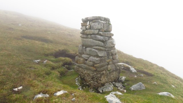
Stac a' Langa is a prominent coastal feature located in Inverness-shire, Scotland. It is a headland that juts out into the sea, forming a distinct point along the coastline. The name "Stac a' Langa" is derived from Gaelic, with "Stac" referring to a stack or pinnacle, and "Langa" translating to a narrow strip of land.

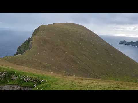
This headland is characterized by its rugged and dramatic cliffs which rise steeply from the ocean below. The cliffs are composed of several layers of sedimentary rock, showcasing the geological history of the area. They are often weathered by the strong coastal winds and waves, creating an impressive sight for visitors.

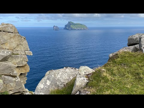
Stac a' Langa offers breathtaking panoramic views of the surrounding coastal landscape, with the vast expanse of the sea stretching out towards the horizon. On clear days, one can even catch a glimpse of distant islands dotting the ocean.

The headland is also home to a diverse range of flora and fauna. The rugged cliffs provide nesting sites for seabirds such as puffins, guillemots, and razorbills. The surrounding waters are teeming with marine life, making it a popular spot for fishing and birdwatching.

Stac a' Langa is easily accessible by foot, with a well-maintained path leading up to the headland. It is a favorite destination for hikers and nature enthusiasts, offering an opportunity to explore the stunning coastal scenery and immerse in the tranquility of the natural surroundings.

Overall, Stac a' Langa is a remarkable coastal feature that showcases the beauty of Inverness-shire's coastline. Whether it's the striking cliffs, diverse wildlife, or breathtaking views, it is a place that captivates the hearts of all who visit.

If you have any feedback on the listing, please let us know in the comments section below.

Stac a' Langa Images

Images are sourced within 2km of 57.82003/-8.5616582 or Grid Reference NA1000. Thanks to Geograph Open Source API. All images are credited.

St Kilda View from Traigh-stir on North Uist at sunset.
St Kilda
View from Traigh-stir on North Uist at sunset.
The Amazon's House, Gleann Mor, St Kilda One of the many structures in Gleann Mor, St Kilda, but this one is the most studied and is named on OS Maps. In Gleann Mor, complex clusters of remains bear affinities with the building traditions of Iron Age wheelhouses, of particular note being the Amazon's House, with its central chamber and linked cells beneath turfed corbelling. <span class="nowrap"><a title="https://canmore.org.uk/site/3960/st-kilda-hirta-gleann-mor-the-amazons-house" rel="nofollow ugc noopener" href="https://canmore.org.uk/site/3960/st-kilda-hirta-gleann-mor-the-amazons-house">Link</a><img style="margin-left:2px;" alt="External link" title="External link - shift click to open in new window" src="https://s1.geograph.org.uk/img/external.png" width="10" height="10"/></span>
The Amazon's House, Gleann Mor, St Kilda
One of the many structures in Gleann Mor, St Kilda, but this one is the most studied and is named on OS Maps. In Gleann Mor, complex clusters of remains bear affinities with the building traditions of Iron Age wheelhouses, of particular note being the Amazon's House, with its central chamber and linked cells beneath turfed corbelling. LinkExternal link
Cleit on the side of Mullach Mòr This spot provides a good view into Gleann Mòr towards The Cambir (An Campar).
Cleit on the side of Mullach Mòr
This spot provides a good view into Gleann Mòr towards The Cambir (An Campar).
Village Bay from the side of Ruabhal, Hirta The military encampment is noticeable and this image was taken when the North Uist Rocket Range was extensively used by NATO.
Village Bay from the side of Ruabhal, Hirta
The military encampment is noticeable and this image was taken when the North Uist Rocket Range was extensively used by NATO.
Mina Stac and the cliffs to its south, Hirta
Radar Tracking Station on Mullach Sgar This radar station, located on Mullach Sgar, is one of two stations on the island which serve the South Uist rocket range. They contain equipment which allows them to track test firings on the range by radar, and to record images of missiles in flight. The second radar station on Hirta is located further north, on the summit of Mullach Mòr.
Radar Tracking Station on Mullach Sgar
This radar station, located on Mullach Sgar, is one of two stations on the island which serve the South Uist rocket range. They contain equipment which allows them to track test firings on the range by radar, and to record images of missiles in flight. The second radar station on Hirta is located further north, on the summit of Mullach Mòr.
Hirta, Mina Stac and the cliffs to its south
Former Quarry Site on Hirta
Mina Stac, Hirta Hirta is surrounded by a number of small stacks. Mina Stac rises spectacularly to a height of approximately 70 metres, separated by only a few feet from the spectacular cliffs (the highest sea cliffs in the UK) which descend from the summit Conachair.
Mina Stac, Hirta
Hirta is surrounded by a number of small stacks. Mina Stac rises spectacularly to a height of approximately 70 metres, separated by only a few feet from the spectacular cliffs (the highest sea cliffs in the UK) which descend from the summit Conachair.
St Kilda, Mina Stac Hirta is surrounded by a number of small stacks. Mina Stac rises spectacularly to a height of approximately 70 metres, separated by only a few feet from the spectacular cliffs (the highest sea cliffs in the UK) which descend from the summit of Conachair, the highest point on the island.
St Kilda, Mina Stac
Hirta is surrounded by a number of small stacks. Mina Stac rises spectacularly to a height of approximately 70 metres, separated by only a few feet from the spectacular cliffs (the highest sea cliffs in the UK) which descend from the summit of Conachair, the highest point on the island.
Radar Tracking Station on Mullach Mor This radar station is located on the summit of Mullach Mor. It is one of two radar stations on the island which serve the South Uist rocket range. They contain equipment which allows them to track test firings on the range by radar, and to record images of missiles in flight. The second radar station on Hirta is located further south, on Mullach Sgar (<a href="https://www.geograph.org.uk/photo/7366677">NF0998 : Radar Tracking Station on Mullach Sgar</a>).
Radar Tracking Station on Mullach Mor
This radar station is located on the summit of Mullach Mor. It is one of two radar stations on the island which serve the South Uist rocket range. They contain equipment which allows them to track test firings on the range by radar, and to record images of missiles in flight. The second radar station on Hirta is located further south, on Mullach Sgar (NF0998 : Radar Tracking Station on Mullach Sgar).
Abhainn Mhòr, Hirta Flowing past the western end of the old village.
Abhainn Mhòr, Hirta
Flowing past the western end of the old village.
Abhainn Mhòr With some of the maintained cleits along the banks.
Abhainn Mhòr
With some of the maintained cleits along the banks.
Soay Sheep, Hirta A very old lineage of sheep, living wild on Hirta and Soay. They are tagged to monitor population fluctuations, which can be quite rapid.
Soay Sheep, Hirta
A very old lineage of sheep, living wild on Hirta and Soay. They are tagged to monitor population fluctuations, which can be quite rapid.
Abhainn Mhòr, Hirta
Abhainn Mhòr, Hirta
Former village, Hirta With Soay Sheep now roaming free on what were the farmed fields.
Former village, Hirta
With Soay Sheep now roaming free on what were the farmed fields.
St Kilda - Trig point below Conachair summit This trig point is located high up on the southern slopes of Conachair. Sadly there was no view on this day with a visibility of around twenty yards and driving fine rain so it wasn't a place to linger.
St Kilda - Trig point below Conachair summit
This trig point is located high up on the southern slopes of Conachair. Sadly there was no view on this day with a visibility of around twenty yards and driving fine rain so it wasn't a place to linger.
Radar station and communications mast on Mullach Mor, St Kilda The summit of Mullach Mor is 361m above sea level. The radar station is manned all year round and used for tracking test missiles from the range on South Uist. The road from the village to the summit was built in 1957 by the military.
Radar station and communications mast on Mullach Mor, St Kilda
The summit of Mullach Mor is 361m above sea level. The radar station is manned all year round and used for tracking test missiles from the range on South Uist. The road from the village to the summit was built in 1957 by the military.
Show me another place!

Stac a' Langa is located at Grid Ref: NA1000 (Lat: 57.82003, Lng: -8.5616582)

Unitary Authority: Na h-Eileanan an Iar

Police Authority: Highlands and Islands

What 3 Words

///alleyway.menu.emailed. Near Balivanich, Na h-Eileanan Siar

Related Wikis

Hirta

Hirta (Scottish Gaelic: Hiort) is the largest island in the St Kilda archipelago, on the western edge of Scotland. The names Hiort (in Scottish Gaelic...

St Kilda, Scotland

St Kilda (Scottish Gaelic: Hiort) is an isolated archipelago situated 64 kilometres (40 mi) west-northwest of North Uist in the North Atlantic Ocean. It...

Dùn

Dùn is an island in St Kilda, Scotland. It is nearly 1 mile (1.6 kilometres) long. Its name simply means "fort" in Scottish Gaelic (for more information...

Stac Biorach

Stac Biorach (Scottish Gaelic: "the pointed stack") is a sea stack, 73 metres tall, situated between Hirta and Soay (in the "Sound of Soay") in the St...

Related Videos

St Kilda, Scotland's Island on the Edge (scenic film + guide)

ST KILDA TRAVEL GUIDE https://www.goingthewholehogg.com/visit-st-kilda-scotland/ ➤ BECOME OUR PATRON ...

The St Kilda Film - A Journey To

This film follows a journey to St Kilda in 2021 with Hebrides Cruises.

St Kilda World Heritage Site

A bucket list trip to St Kilda. I hadn't intended filming much at all. But I took what little footage I had to make a short.

Nearby Amenities

Located within 500m of 57.82003,-8.5616582
Stac a' Langa
Natural: cape
Source: npe
Wikidata: Q24677220
Lat/Long: 57.8204959/-8.5615766
Natural: rock
Seamark Type: rock
Lat/Long: 57.8195147/-8.5603912
Natural: rock
Seamark Type: rock
Lat/Long: 57.8190297/-8.5600985
Natural: rock
Seamark Type: rock
Lat/Long: 57.8207359/-8.5609685
Natural: rock
Seamark Type: rock
Lat/Long: 57.821498/-8.5636761
Natural: rock
Seamark Type: rock
Lat/Long: 57.8213291/-8.5640176
Am Broig
Natural: cape
Lat/Long: 57.8177782/-8.5591465
Geo a' Bhroige
Natural: bay
Lat/Long: 57.8184411/-8.5598117
Geo na Eaige
Natural: bay
Lat/Long: 57.8175382/-8.5580307
The data included in this document is from www.openstreetmap.org. The data is made available under ODbL.

Have you been to Stac a' Langa?

Leave your review of Stac a' Langa below (or comments, questions and feedback).