Quab

Sea, Estuary, Creek in Shetland

Scotland

Quab

Ness of Queyon Taken on the B9081 as we pass through East Yell, Yell, Shetland, I am looking across Otters Wick to the Ness of Queyon, the croft of the same name and the Hill of Queyon. The cliffs of Hascosay and Mid Yell can be seen beyond.
Ness of Queyon Credit: Carroll Pierce

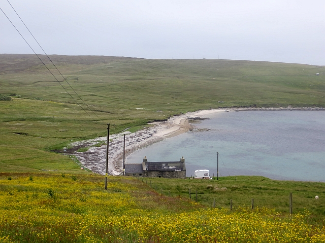
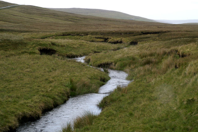
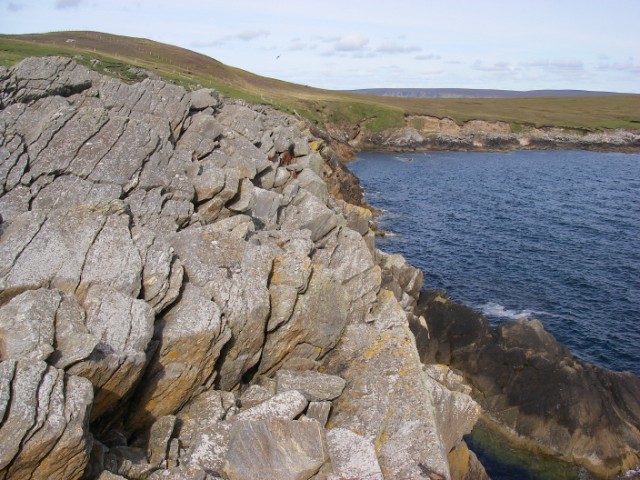
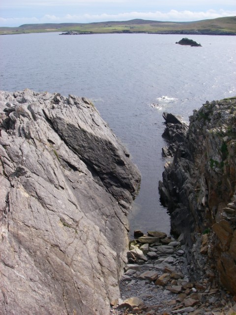
Quab is a small but picturesque sea inlet located in Shetland, Scotland. Nestled in between rolling hills and cliffs, this estuary-creek hybrid offers a unique blend of natural beauty and tranquility. The name "Quab" originates from the Old Norse word "kvafr," meaning "deep pool," which accurately describes the deep, calm waters found here.

The entrance to Quab is narrow, with steep cliffs on either side, providing protection against the tumultuous North Sea. As you venture further into the inlet, the rugged coastline gives way to a more serene landscape of sandy beaches and rocky outcrops. The crystal-clear waters of Quab are teeming with marine life, making it a popular spot for fishing and birdwatching.

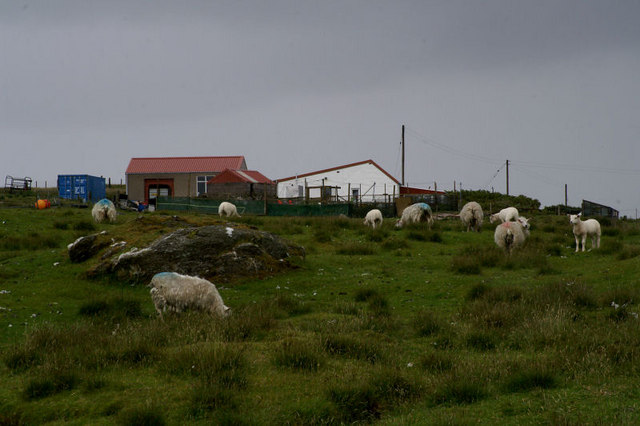
The surrounding area boasts an abundance of wildlife, including seals, otters, and a variety of seabirds. Visitors to Quab can often catch glimpses of these fascinating creatures as they go about their daily routines.

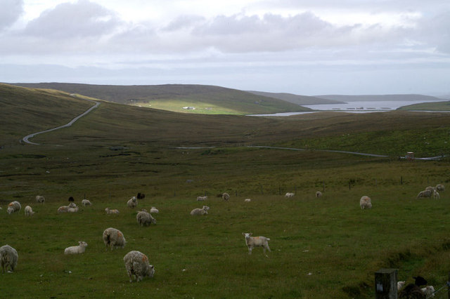
The tranquil atmosphere of Quab makes it an idyllic spot for leisurely walks or picnics. The surrounding countryside offers breathtaking views of the inlet, with its ever-changing tides and shimmering waters. Additionally, the nearby hills provide ample opportunities for hiking, offering panoramic vistas of the surrounding landscape.

Overall, Quab is a hidden gem in Shetland, providing visitors with a chance to immerse themselves in the natural beauty and serenity of the Scottish coast. Whether you're seeking a peaceful retreat or an adventure in nature, Quab is sure to captivate and leave a lasting impression.

If you have any feedback on the listing, please let us know in the comments section below.

Quab Images

Images are sourced within 2km of 60.553717/-1.0121912 or Grid Reference HU5485. Thanks to Geograph Open Source API. All images are credited.
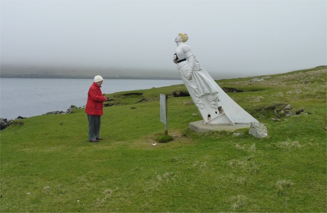
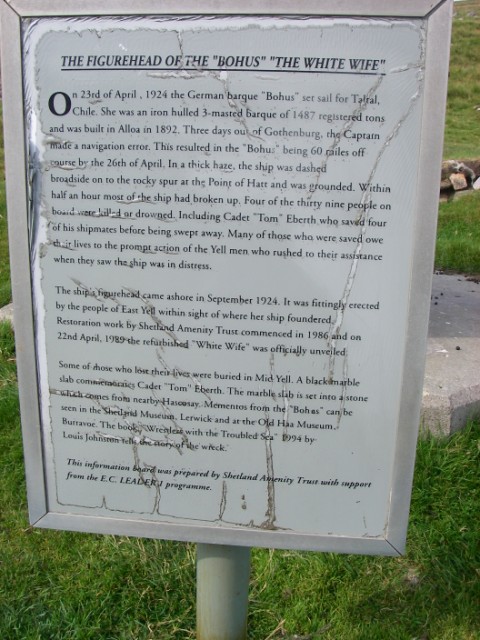
Ness of Queyon Taken on the B9081 as we pass through East Yell, Yell, Shetland, I am looking across Otters Wick to the Ness of Queyon, the croft of the same name and the Hill of Queyon. The cliffs of Hascosay and Mid Yell can be seen beyond.
Ness of Queyon
Taken on the B9081 as we pass through East Yell, Yell, Shetland, I am looking across Otters Wick to the Ness of Queyon, the croft of the same name and the Hill of Queyon. The cliffs of Hascosay and Mid Yell can be seen beyond.
East Yell: postbox № ZE2 59 A small postbox alongside a bus shelter at the junction, a short distance from the post office. The box is emptied at half past nine on weekday and Saturday mornigs.
East Yell: postbox № ZE2 59
A small postbox alongside a bus shelter at the junction, a short distance from the post office. The box is emptied at half past nine on weekday and Saturday mornigs.
East Yell: the White Wife This unusual monument commemorates a shipping disaster in April 1924. Setting sail from Gothenburg, bound for Chile, the 'Bohus' had been sailing for three days when a navigational error resulted in the ship becoming grounded a short distance from here, some 60 miles off her intended course. Within half an hour most of the ship had broken up.

Four of the 39 on board perished, and the survivors owed a lot to the men of Yell who acted swiftly when they saw the tragedy emerging.

The ship's figurehead was washed ashore in September 1924 and this is what we see here: erected by local people as a memorial to the tragedy, within sight of where it occurred.
East Yell: the White Wife
This unusual monument commemorates a shipping disaster in April 1924. Setting sail from Gothenburg, bound for Chile, the 'Bohus' had been sailing for three days when a navigational error resulted in the ship becoming grounded a short distance from here, some 60 miles off her intended course. Within half an hour most of the ship had broken up. Four of the 39 on board perished, and the survivors owed a lot to the men of Yell who acted swiftly when they saw the tragedy emerging. The ship's figurehead was washed ashore in September 1924 and this is what we see here: erected by local people as a memorial to the tragedy, within sight of where it occurred.
East Yell: the White Wife looks out Another view of <a href="https://www.geograph.org.uk/photo/2651277">HU5285 : East Yell: the White Wife</a>, from behind her as she looks out across Otters Wick. Black Skerry is the rock in the centre of the picture.

This unusual monument commemorates a shipping disaster in April 1924. Setting sail from Gothenburg, bound for Chile, the 'Bohus' had been sailing for three days when a navigational error resulted in the ship becoming grounded a short distance from here, some 60 miles off her intended course. Within half an hour most of the ship had broken up.

Four of the 39 on board perished, and the survivors owed a lot to the men of Yell who acted swiftly when they saw the tragedy emerging.

The ship's figurehead was washed ashore in September 1924 and this is what we see here: erected by local people as a memorial to the tragedy, within sight of where it occurred.
East Yell: the White Wife looks out
Another view of HU5285 : East Yell: the White Wife, from behind her as she looks out across Otters Wick. Black Skerry is the rock in the centre of the picture. This unusual monument commemorates a shipping disaster in April 1924. Setting sail from Gothenburg, bound for Chile, the 'Bohus' had been sailing for three days when a navigational error resulted in the ship becoming grounded a short distance from here, some 60 miles off her intended course. Within half an hour most of the ship had broken up. Four of the 39 on board perished, and the survivors owed a lot to the men of Yell who acted swiftly when they saw the tragedy emerging. The ship's figurehead was washed ashore in September 1924 and this is what we see here: erected by local people as a memorial to the tragedy, within sight of where it occurred.
East Yell: north edge of Otters Wick Looking down on the head of Otters Wick.
East Yell: north edge of Otters Wick
Looking down on the head of Otters Wick.
Otters Wick Beach at Otterswick.
Otters Wick
Beach at Otterswick.
Lady in red studies White Wife The story of how the 'White Wife' (aka 'Wudden Wife') ship's figurehead came to be at Otterswick is told here <a href="https://www.geograph.org.uk/photo/1453591">HU5285 : The White Wife: an explanation</a>.
Lady in red studies White Wife
The story of how the 'White Wife' (aka 'Wudden Wife') ship's figurehead came to be at Otterswick is told here HU5285 : The White Wife: an explanation.
Stone walls and fishing nets With the Black Skerry rock in Otters Wick in the background.
Stone walls and fishing nets
With the Black Skerry rock in Otters Wick in the background.
White Wife View of the Hill of Queyon, with the 'White Wife' (an old ship's figurehead rescued from a wreck) on the near shore.  The bay in the foreground is Otters Wick, the island of Fetlar is in the background.  View from the hill above Otterswick village.
White Wife
View of the Hill of Queyon, with the 'White Wife' (an old ship's figurehead rescued from a wreck) on the near shore. The bay in the foreground is Otters Wick, the island of Fetlar is in the background. View from the hill above Otterswick village.
White Wife, Yell, Shetland The figurehead of the German barque, Bohus, which ran aground in 1924
White Wife, Yell, Shetland
The figurehead of the German barque, Bohus, which ran aground in 1924
Figurehead of the "White Wife" According to local tradition (and thus published many times) The White Wife (or White Lady) of Otterswick is said to be a German lady. 

According to her life records we have to say that Bertha is a British girl or more correctly a Scottish girl, "born in Grangemouth of German parents". 

She was the figurehead of the steel barque Bertha built in 1892 by Grangemouth Dockyard Co., Grangemouth, as yard no. 163. Her dimensions were: 74,11×11,70×6,88 metres [248'2"×38'4"×22'4"] and with a tonnage of 1653 GRT (1499 NRT and 2600 DWT). She was launched at the shipyard of Grangemouth Dockyard Co. for Joh. H. Soost, Hamburg on July 6th, 1892 and assigned the official German signal RJQD. 

She was named after Bertha, the eldest daughter of Joh. H. Soost, and this should be the proper name of The White Lady. 

In 1899 she was sold to Captain M. Dietrich, Hamburg, and thereafter changed hands several times. In her great days until 1912 she did a lot of long distance runs such as 1904 from Lizard Point to Seattle in 154 days, 1906 from Lizard Point to Sydney in 117 days and again in 1909 in 114 days or in 1910 from Sydney to Falmouth f/o in 129 days. 

In 1912 she was sold to Sweden changed hands several times and ended up with Förnyade Ångfartygs AB Viking, Gothenburg, for SEK 500.000. She was then renamed Bohus and assigned the official Swedish Reg. No. 5903 and signal KBCV. Captain at that time was Mr Ragnar Erik Nyberg, Stockholm. Bertha was bound to the Baltic Sea, mostly sailing in Swedish and Finnish waters.
Figurehead of the "White Wife"
According to local tradition (and thus published many times) The White Wife (or White Lady) of Otterswick is said to be a German lady. According to her life records we have to say that Bertha is a British girl or more correctly a Scottish girl, "born in Grangemouth of German parents". She was the figurehead of the steel barque Bertha built in 1892 by Grangemouth Dockyard Co., Grangemouth, as yard no. 163. Her dimensions were: 74,11×11,70×6,88 metres [248'2"×38'4"×22'4"] and with a tonnage of 1653 GRT (1499 NRT and 2600 DWT). She was launched at the shipyard of Grangemouth Dockyard Co. for Joh. H. Soost, Hamburg on July 6th, 1892 and assigned the official German signal RJQD. She was named after Bertha, the eldest daughter of Joh. H. Soost, and this should be the proper name of The White Lady. In 1899 she was sold to Captain M. Dietrich, Hamburg, and thereafter changed hands several times. In her great days until 1912 she did a lot of long distance runs such as 1904 from Lizard Point to Seattle in 154 days, 1906 from Lizard Point to Sydney in 117 days and again in 1909 in 114 days or in 1910 from Sydney to Falmouth f/o in 129 days. In 1912 she was sold to Sweden changed hands several times and ended up with Förnyade Ångfartygs AB Viking, Gothenburg, for SEK 500.000. She was then renamed Bohus and assigned the official Swedish Reg. No. 5903 and signal KBCV. Captain at that time was Mr Ragnar Erik Nyberg, Stockholm. Bertha was bound to the Baltic Sea, mostly sailing in Swedish and Finnish waters.
Hogalee Burn The burn rises on the hill of Hoga Lee and flows into the Loch of Vatsetter but, like several other Shetland burns, it has several names along the way.
Hogalee Burn
The burn rises on the hill of Hoga Lee and flows into the Loch of Vatsetter but, like several other Shetland burns, it has several names along the way.
Moorhouse, North Aywick
Tin house at South Aywick Once quite widespread in Shetland, very few of these houses remain.
Tin house at South Aywick
Once quite widespread in Shetland, very few of these houses remain.
Valley of the Burn of Hogalee Looking towards Vatsetter.
Valley of the Burn of Hogalee
Looking towards Vatsetter.
Coast near Ness of Queyon
View to Black Skerry This geo is just to the east of the White Wife.
View to Black Skerry
This geo is just to the east of the White Wife.
The White Wife: an explanation This figurehead makes for something of a curiosity.
The White Wife: an explanation
This figurehead makes for something of a curiosity.
Show me another place!

Quab is located at Grid Ref: HU5485 (Lat: 60.553717, Lng: -1.0121912)

Unitary Authority: Shetland Islands

Police Authority: Highlands and Islands

What 3 Words

///squad.relishes.disbelief. Near Houbie, Shetland Islands

Related Wikis

Aywick

Aywick is a small settlement on the east side of Yell, an island forming part of the Shetland Islands north of Scotland.The naturalist Bobby Tulloch was...

Otterswick

Otterswick is a hamlet on the island of Yell in the Shetland Islands, on the inlet of Otters Wick. It is on the east side of the island. There is also...

Gossabrough

Gossabrough is a coastal hamlet, wick and ness on the southeast side of the island of Yell, Shetland, Scotland. The Wick of Gossabrough lies between the...

Mid Yell

Mid Yell is a coastal settlement on the island of Yell, the second largest of Shetland Islands, Scotland. Mid Yell, the largest settlement on the island...

Burra Voe

Burra Voe (Old Norse: Borgavagr, Broch Bay) is sheltered bay (voe) at the southeast corner of the island of Yell. The village of Burravoe (HU525795) is...

Burravoe

Burravoe is a community on the north shore of Burra Voe, in the south-east part of the island of Yell in the Shetland Islands, Scotland. The name Burravoe...

Old Haa Museum

The Old Haa of Brough in located in Burravoe, Yell, Shetland, Scotland. Built for Robert Tyrie, a merchant, in 1672, houses the local museum for Burravoe...

Hascosay

Hascosay (Scots: Hascosay; Old Norse "Hafskotsey") is a small island lying between Yell and Fetlar in the Shetland Islands, Scotland. == Geography and... ==

Have you been to Quab?

Leave your review of Quab below (or comments, questions and feedback).