Hascosay Sound

Sea, Estuary, Creek in Shetland

Scotland

Hascosay Sound

Black Guillemot (Cepphus grylle), Djuba Wick, Hascosay A Tystie, as they are known locally, in winter plumage.
Black Guillemot (Cepphus grylle), Djuba Wick, Hascosay Credit: Mike Pennington

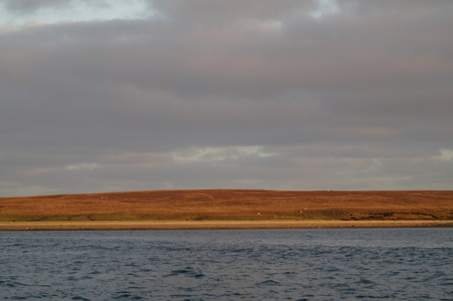
Hascosay Sound is a sea channel located in the Shetland Islands, which lie off the northeast coast of Scotland. It separates the larger islands of Whalsay and East Burra from the smaller islands of Hascosay and Linga. The sound stretches for approximately 2.5 kilometers (1.5 miles) and has a maximum width of around 1 kilometer (0.6 miles).

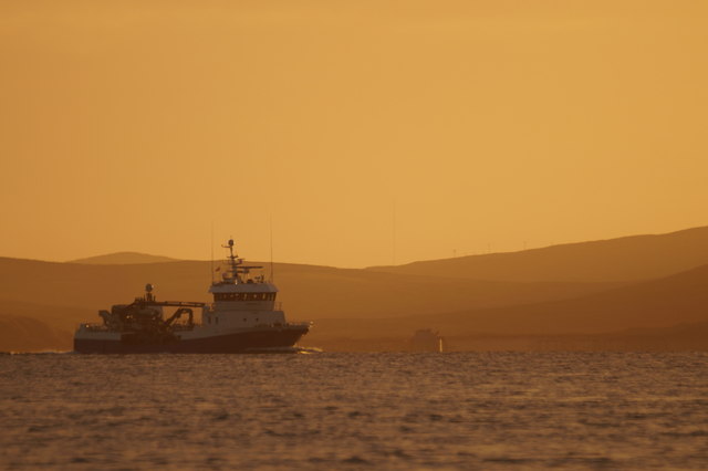
As a sea channel, Hascosay Sound experiences the ebb and flow of tides, with currents that can be quite strong. The surrounding landscape is characterized by rocky shores and cliffs, providing a picturesque backdrop to the sound. The water is generally deep and clear, allowing for excellent visibility and making it a popular spot for diving and snorkeling.

The sound is also home to a diverse range of marine life. Seals can often be spotted basking on the rocks, while seabirds like gannets, fulmars, and kittiwakes can be seen diving and fishing in the surrounding waters. The area is also known for its rich fishing grounds, attracting both commercial and recreational fishermen.

Hascosay Sound serves as an important transportation route for the local communities, as it allows for the movement of people and goods between the islands. Ferries and small boats regularly traverse the sound, providing a vital link for residents and visitors alike.

Overall, Hascosay Sound is a beautiful and dynamic sea channel, offering stunning views, diverse wildlife, and important transportation connections for the Shetland Islands.

If you have any feedback on the listing, please let us know in the comments section below.

Hascosay Sound Images

Images are sourced within 2km of 60.62112/-1.0131465 or Grid Reference HU5493. Thanks to Geograph Open Source API. All images are credited.

Black Guillemot (Cepphus grylle), Djuba Wick, Hascosay A Tystie, as they are known locally, in winter plumage.
Black Guillemot (Cepphus grylle), Djuba Wick, Hascosay
A Tystie, as they are known locally, in winter plumage.
Salmon farm in Djuba Wick, Hascosay
Salmon farm in Djuba Wick, Hascosay The round grey floating structure, known as a 'salmon barge' is basically a huge feed container, the black tubes leading out of it going to feeders in the cages, all controlled by computer and radio relays from on land.
Salmon farm in Djuba Wick, Hascosay
The round grey floating structure, known as a 'salmon barge' is basically a huge feed container, the black tubes leading out of it going to feeders in the cages, all controlled by computer and radio relays from on land.
Headland west of Djuba Wick, Hascosay
Common Eider (Somateria mollissima), Djuba Wick, Hascosay One of a flock feeding around the salmon farm.
Common Eider (Somateria mollissima), Djuba Wick, Hascosay
One of a flock feeding around the salmon farm.
Salmon barge, Djuba Wick, Hascosay The round grey floating structure, known as a 'salmon barge' is basically a huge feed container, the black tubes leading out of it going to feeders in the cages, all controlled by computer and radio relays from on land.
Salmon barge, Djuba Wick, Hascosay
The round grey floating structure, known as a 'salmon barge' is basically a huge feed container, the black tubes leading out of it going to feeders in the cages, all controlled by computer and radio relays from on land.
Salmon farm off Basta Ness
North end of the Bow of Hascosay
Basta Ness from the sea
MV Norholm in Hascosay Sound
West end of Burra Ness from the sea
West end of Burra Ness from the sea The hill of Burraness in the background.
West end of Burra Ness from the sea
The hill of Burraness in the background.
Coastline of Burra Ness from the sea
Great Northern Divers (Gavia immer) off Burra Ness
Sunset beyond Hascosay The sun sets behind Yell; taken from the sea south of Linga.
Sunset beyond Hascosay
The sun sets behind Yell; taken from the sea south of Linga.
Herring Gull (Larus argentatus), Djuba Wick, Hascosay A second-winter bird, looking for easy pickings around a salmon-farm.
Herring Gull (Larus argentatus), Djuba Wick, Hascosay
A second-winter bird, looking for easy pickings around a salmon-farm.
Looking across Housa Wick towards the west end of Hascosay
Hascosay Sound from Hascosay
Show me another place!

Hascosay Sound is located at Grid Ref: HU5493 (Lat: 60.62112, Lng: -1.0131465)

Unitary Authority: Shetland Islands

Police Authority: Highlands and Islands

What 3 Words

///wheat.dignitary.rollover. Near Gutcher, Shetland Islands

Nearby Locations

Hascosay Sound Taingar

Related Wikis

Hascosay

Hascosay (Scots: Hascosay; Old Norse "Hafskotsey") is a small island lying between Yell and Fetlar in the Shetland Islands, Scotland. == Geography and... ==

Basta, Shetland

Basta is a hamlet on the island of Yell in the Shetland islands of Scotland. It is on the shores of Basta Voe and is in the parish of Yell. == References... ==

Burra Ness Broch

Burra Ness Broch is an iron-age broch located on the east coast of the island of Yell, Shetland, Scotland. == Location == Burra Ness Broch (grid reference...

Mid Yell

Mid Yell is a coastal settlement on the island of Yell, the second largest of Shetland Islands, Scotland. Mid Yell, the largest settlement on the island...

Have you been to Hascosay Sound?

Leave your review of Hascosay Sound below (or comments, questions and feedback).