Castle Cove

Sea, Estuary, Creek in Dorset

England

Castle Cove

Weymouth Harbour Weymouth Harbour, photographed from the Town Bridge.
Weymouth Harbour Credit: Malc McDonald

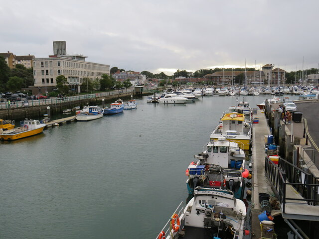
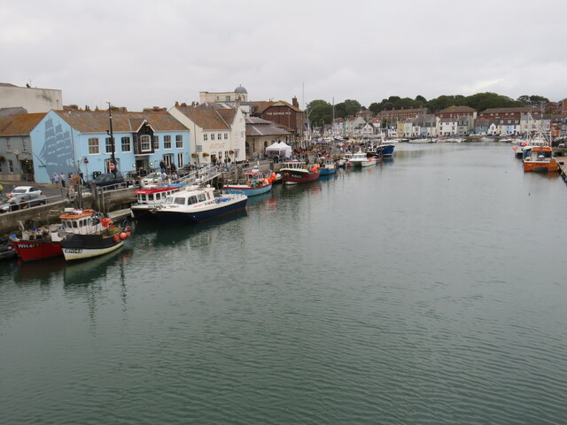
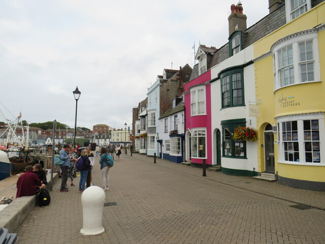
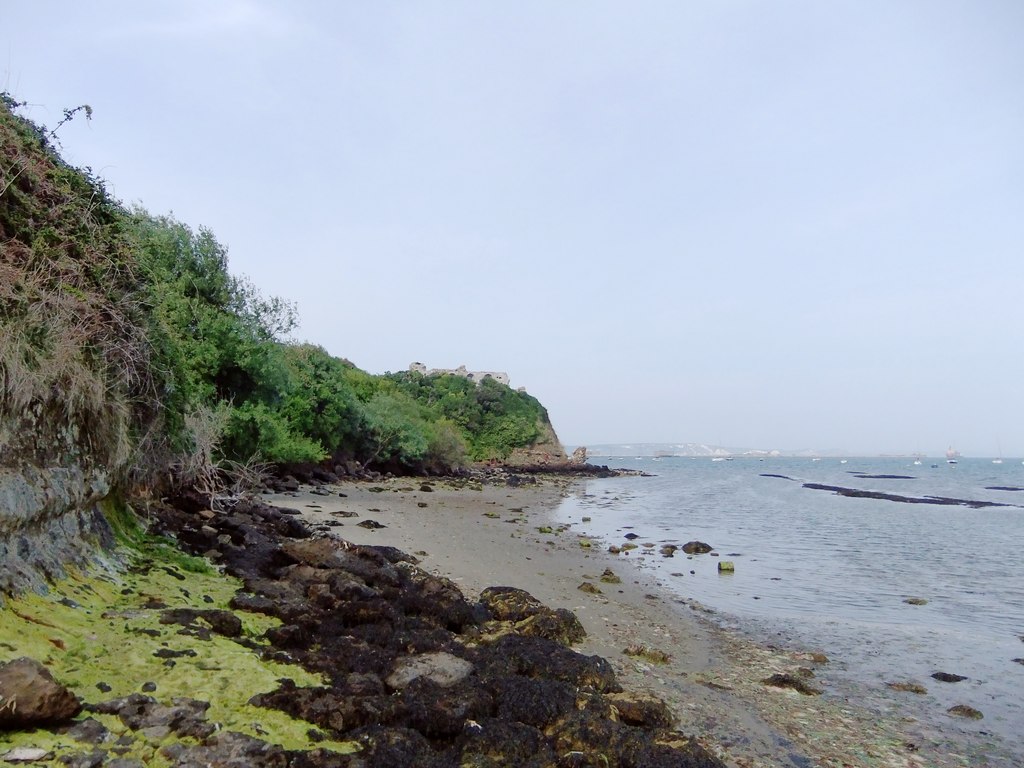
Castle Cove is a picturesque coastal area located in Dorset, England. Situated along the stunning Jurassic Coastline, it offers a breathtaking view of the sea, estuary, and creek. The area is known for its natural beauty, making it a popular destination for nature lovers and outdoor enthusiasts.

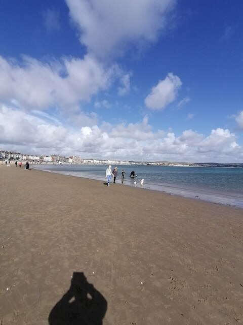
The sea at Castle Cove is a prominent feature, with its crystal-clear waters and sandy beaches. It provides ample opportunities for swimming, sailing, and various water sports activities. The calm and refreshing atmosphere of the sea is perfect for a relaxing day out by the shore or a fun-filled family outing.

The estuary at Castle Cove adds another dimension to the landscape. It is formed where the river meets the sea, creating a unique ecosystem that supports a diverse range of marine life. The estuary also serves as a habitat for various bird species, making it a popular spot for birdwatching enthusiasts.

The creek at Castle Cove adds to the charm of the area. With its tranquil waters and surrounding lush greenery, it offers a serene and peaceful environment for visitors to enjoy. The creek is an ideal spot for fishing, kayaking, and exploring the scenic beauty of the region.

Castle Cove is also home to a wide range of flora and fauna, including rare plant species and wildlife. The area is designated as an Area of Outstanding Natural Beauty, highlighting its significance in terms of conservation and preservation.

Overall, Castle Cove in Dorset is a must-visit destination for those seeking a blend of natural beauty, coastal charm, and outdoor activities. Its sea, estuary, and creek provide a diverse and captivating experience for visitors of all ages.

If you have any feedback on the listing, please let us know in the comments section below.

Castle Cove Images

Images are sourced within 2km of 50.596488/-2.4596073 or Grid Reference SY6777. Thanks to Geograph Open Source API. All images are credited.

Weymouth Harbour Weymouth Harbour, photographed from the Town Bridge.
Weymouth Harbour
Weymouth Harbour, photographed from the Town Bridge.
River Wey, Weymouth The River Way flowing through Weymouth, where it will flow into the sea.
River Wey, Weymouth
The River Way flowing through Weymouth, where it will flow into the sea.
Town Bridge, Weymouth Town Bridge is a lifting bridge which crosses the River Wey at Weymouth Harbour.  This bridge dates from 1930, replacing a previous bridge.  There has been a bridge on this site, linking Weymouth and Melcombe Regis, since 1597.

More information about the bridge can be found on the Weymouth Harbour website: <span class="nowrap"><a title="https://www.weymouth-harbour.co.uk/townbridge/" rel="nofollow ugc noopener" href="https://www.weymouth-harbour.co.uk/townbridge/">Link</a><img style="margin-left:2px;" alt="External link" title="External link - shift click to open in new window" src="https://s1.geograph.org.uk/img/external.png" width="10" height="10"/></span>
Town Bridge, Weymouth
Town Bridge is a lifting bridge which crosses the River Wey at Weymouth Harbour. This bridge dates from 1930, replacing a previous bridge. There has been a bridge on this site, linking Weymouth and Melcombe Regis, since 1597. More information about the bridge can be found on the Weymouth Harbour website: LinkExternal link
Trinity Road, Weymouth Trinity Road on the quayside at Weymouth.
Trinity Road, Weymouth
Trinity Road on the quayside at Weymouth.
St. Alban Street, Weymouth St. Alban Street is a narrow street in Weymouth's old town. The sign to the left of the street indicates that it is pedestrianised, except for access between specified times.
St. Alban Street, Weymouth
St. Alban Street is a narrow street in Weymouth's old town. The sign to the left of the street indicates that it is pedestrianised, except for access between specified times.
Radipole Lake, Weymouth The River Wey flows through Radipole Lake as it approaches the centre of Weymouth.
Radipole Lake, Weymouth
The River Wey flows through Radipole Lake as it approaches the centre of Weymouth.
Weymouth beach  Weymouth beach on this glorious Sunday afternoon
Weymouth beach
Weymouth beach on this glorious Sunday afternoon
Weymouth Harbour  Weymouth Harbour on this glorious Sunday afternoon
Weymouth Harbour
Weymouth Harbour on this glorious Sunday afternoon
Weymouth town centre  Weymouth town centre on this glorious Sunday afternoon
Weymouth town centre
Weymouth town centre on this glorious Sunday afternoon
White out in Gloucester Mews A commercial property in the streets behind the seafront has a bright frontage.
White out in Gloucester Mews
A commercial property in the streets behind the seafront has a bright frontage.
Inside and outside walls at the same time Some work needed quickly in this building in Gloucester Mews, although it doesn't look like it hasn't had any.
Inside and outside walls at the same time
Some work needed quickly in this building in Gloucester Mews, although it doesn't look like it hasn't had any.
Overlooking Great George Street A corner property has an unususal balcony projecting over the street. However, there is a bit of a debate here - see <a href="https://www.geograph.org.uk/photo/7033224">SY6779 : Where exactly are we?</a>.
Overlooking Great George Street
A corner property has an unususal balcony projecting over the street. However, there is a bit of a debate here - see SY6779 : Where exactly are we?.
Where exactly are we? The old plate sign seems to be the preferred option; the tiled alternative does not appear to have any basis on old maps.
Where exactly are we?
The old plate sign seems to be the preferred option; the tiled alternative does not appear to have any basis on old maps.
Finn's pub in Weymouth A hot-spot for live music.
Finn's pub in Weymouth
A hot-spot for live music.
An interesting thing Something has come up on the screen. Perhaps it take the mind off feeling that someone is watching.
An interesting thing
Something has come up on the screen. Perhaps it take the mind off feeling that someone is watching.
Don't upset Nan! A pointed and rather stern message on a litter bin.
Don't upset Nan!
A pointed and rather stern message on a litter bin.
Clipped for good The Clipper shut its doors in 2013, with little sign of any change as yet. It is a grand old  town house that used to be known as The Old Rectory.
Clipped for good
The Clipper shut its doors in 2013, with little sign of any change as yet. It is a grand old town house that used to be known as The Old Rectory.
Grand Georgian style in St Thomas Street Not in Great George Street, paradoxically, but this former rectory-turned-pub is actually a pair of grand town houses built in the late eighteenth century. The set back from the street is a result of the massive retail development of this part of Weymouth in the 1990s, whereupon the shops now stand forward of the old house.

Grade II listed (and currently several years left empty), note the Flemish Bond brickwork.
Grand Georgian style in St Thomas Street
Not in Great George Street, paradoxically, but this former rectory-turned-pub is actually a pair of grand town houses built in the late eighteenth century. The set back from the street is a result of the massive retail development of this part of Weymouth in the 1990s, whereupon the shops now stand forward of the old house. Grade II listed (and currently several years left empty), note the Flemish Bond brickwork.
Show me another place!

Castle Cove is located at Grid Ref: SY6777 (Lat: 50.596488, Lng: -2.4596073)

Unitary Authority: Dorset

Police Authority: Dorset

What 3 Words

///lists.secret.pipes. Near Weymouth, Dorset

Related Wikis

Castle Cove, Weymouth

Castle Cove, also known as Sandsfoot Cove, is a small secluded sand beach to the west of Weymouth, in Dorset, southern England. It is in the parish of...

Sandsfoot Castle Halt railway station

Sandsfoot Castle Halt was a small railway station on the Portland Branch Railway between Weymouth and Portland in Dorset. == Station == Opened on 1 August...
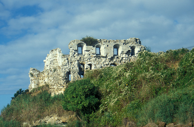
Sandsfoot Castle

Sandsfoot Castle, also known historically as Weymouth Castle, is an artillery fort constructed by Henry VIII near Weymouth, Dorset. It formed part of the...

Portland House, Weymouth

Portland House is a 20th-century detached house, located at Weymouth, Dorset, England. It is found in the area known as Bincleaves, overlooking Portland...

Nearby Amenities

Located within 500m of 50.596488,-2.4596073
Source: PGS
Lat/Long: 50.5934647/-2.4642141
Source: PGS
Lat/Long: 50.5939823/-2.4640454
Source: PGS
Lat/Long: 50.5943326/-2.4633908
Source: PGS
Lat/Long: 50.5944183/-2.4630494
Source: PGS
Lat/Long: 50.5943658/-2.4628214
Created By: almien_coastlines
Source: PGS
Lat/Long: 50.5944345/-2.4626221
Created By: almien_coastlines
Source: PGS
Lat/Long: 50.5946653/-2.4620154
Created By: almien_coastlines
Source: PGS
Lat/Long: 50.5946812/-2.4612909
Created By: almien_coastlines
Source: PGS
Lat/Long: 50.594934/-2.4605107
Created By: almien_coastlines
Source: PGS
Lat/Long: 50.595406/-2.4603655
Created By: almien_coastlines
Source: PGS
Lat/Long: 50.5958112/-2.4602648
Created By: almien_coastlines
Source: PGS
Lat/Long: 50.5962171/-2.4600628
Created By: almien_coastlines
Source: PGS
Lat/Long: 50.5965712/-2.4600118
Created By: almien_coastlines
Source: PGS
Lat/Long: 50.596885/-2.459747
Created By: almien_coastlines
Source: PGS
Lat/Long: 50.597394/-2.458935
Created By: almien_coastlines
Source: PGS
Lat/Long: 50.597518/-2.458129
Created By: almien_coastlines
Source: PGS
Lat/Long: 50.597645/-2.457926
Created By: almien_coastlines
Source: PGS
Lat/Long: 50.598026/-2.457317
Source: PGS
Lat/Long: 50.5983023/-2.45647
Source: PGS
Lat/Long: 50.5985747/-2.4556009
Created By: almien_coastlines
Source: PGS
Lat/Long: 50.598784/-2.454892
Created By: almien_coastlines
Source: PGS
Lat/Long: 50.598912/-2.45469
Created By: almien_coastlines
Source: PGS
Lat/Long: 50.599038/-2.454487
Created By: almien_coastlines
Source: PGS
Lat/Long: 50.599037/-2.454084
Turning Circle
Lat/Long: 50.5989313/-2.4644614
Bus Stop
Southlands Road
Bench: yes
Bus: yes
Local Ref: 1200DOB20091
Naptan AtcoCode: 1200DOB20091
Naptan Bearing: E
Naptan CommonName: Southlands Road
Naptan Indicator: E-bound
Naptan NaptanCode: dorajdpt
Naptan PlusbusZoneRef: WEYMTH
Naptan Street: Buxton Road
Naptan Verified: no
Public Transport: platform
Shelter: yes
Lat/Long: 50.6005216/-2.462452
Barrier: kerb
Bicycle: designated
Crossing: uncontrolled
Kerb: flush
Segregated: no
Lat/Long: 50.595831/-2.4622454
Leisure: slipway
Lat/Long: 50.5933475/-2.4640745
Leisure: slipway
Lat/Long: 50.5942022/-2.4638699
Toilets
Lat/Long: 50.596083/-2.4612664
Generator Method: photovoltaic
Generator Output Electricity: yes
Generator Source: solar
Generator Type: solar_photovoltaic_panel
Location: roof
Power: generator
Lat/Long: 50.5986368/-2.4649608
Generator Method: photovoltaic
Generator Output Electricity: yes
Generator Source: solar
Generator Type: solar_photovoltaic_panel
Location: roof
Power: generator
Lat/Long: 50.5983082/-2.4653712
Generator Method: photovoltaic
Generator Output Electricity: yes
Generator Source: solar
Generator Type: solar_photovoltaic_panel
Location: roof
Power: generator
Lat/Long: 50.5983201/-2.4654141
Generator Method: photovoltaic
Generator Output Electricity: yes
Generator Source: solar
Generator Type: solar_photovoltaic_panel
Location: roof
Power: generator
Lat/Long: 50.59847/-2.4657762
Generator Method: photovoltaic
Generator Output Electricity: yes
Generator Source: solar
Generator Type: solar_photovoltaic_panel
Location: roof
Power: generator
Lat/Long: 50.5984189/-2.4655938
Generator Method: photovoltaic
Generator Output Electricity: yes
Generator Source: solar
Generator Type: solar_photovoltaic_panel
Location: roof
Power: generator
Lat/Long: 50.5982844/-2.4634668
Generator Method: photovoltaic
Generator Output Electricity: yes
Generator Source: solar
Generator Type: solar_photovoltaic_panel
Location: roof
Power: generator
Lat/Long: 50.5983218/-2.4630806
Generator Method: photovoltaic
Generator Output Electricity: yes
Generator Source: solar
Generator Type: solar_photovoltaic_panel
Location: roof
Power: generator
Lat/Long: 50.5970926/-2.4631745
Sandsfoot Castle
Historic Railway: halt
Railway: site
Wikidata: Q7416936
Wikipedia: en:Sandsfoot Castle Halt railway station
Lat/Long: 50.5966182/-2.4614821
Post Box
Collection Times: Mo-Fr 09:00; Sa 07:00
Operator: Royal Mail
Operator Wikidata: Q638098
Post Box Type: lamp
Ref: DT4 100D
Ref GB Uprn: 10015457816
Royal Cypher: EIIR
Royal Cypher Wikidata: Q33102113
Source: survey
Survey Date: 2022-09-10
Lat/Long: 50.5974625/-2.4637404
Post Box
Collection Times: Mo-Fr 09:00; Sa 07:00
Operator: Royal Mail
Operator Wikidata: Q638098
Post Box Type: pillar
Ref: DT4 84D
Ref GB Uprn: 10015358703
Royal Cypher: GR
Royal Cypher Wikidata: Q33102273
Source: survey
Survey Date: 2022-09-10
Lat/Long: 50.6005313/-2.4611353
The data included in this document is from www.openstreetmap.org. The data is made available under ODbL.

Have you been to Castle Cove?

Leave your review of Castle Cove below (or comments, questions and feedback).