Southlands

Settlement in Dorset

England

Southlands

Weymouth beach  Weymouth beach on this glorious Sunday afternoon
Weymouth beach Credit: Ryan Griffiths

Southlands is a picturesque village located in the county of Dorset, England. Situated in the stunning countryside, it offers breathtaking views and a serene environment for residents and visitors alike. The village is nestled in the heart of the South Dorset Downs, a designated Area of Outstanding Natural Beauty, making it a popular destination for nature lovers and outdoor enthusiasts.

The village is home to a close-knit community, with a population of around 500 people. It boasts a charming village center with a few local shops, a post office, and a traditional pub, serving as the social hub for residents. Southlands is known for its quaint thatched cottages and historic buildings, which add to its old-world charm.

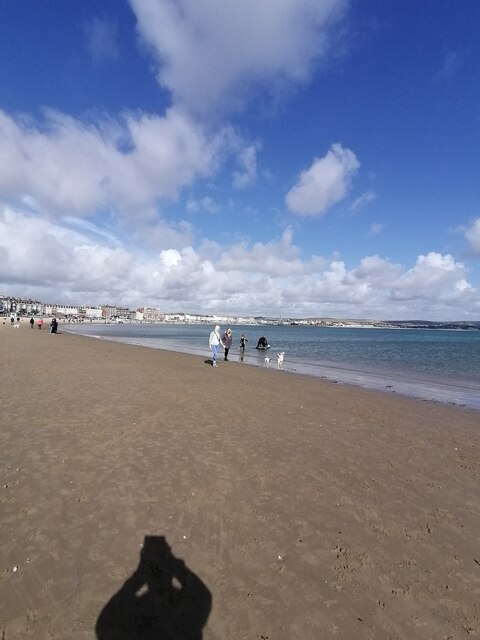
Surrounded by rolling hills and lush green fields, Southlands offers ample opportunities for outdoor activities. The village is crisscrossed by numerous footpaths and bridleways, making it a haven for hikers, cyclists, and horse riders. The nearby Southlands Beach, located just a short distance from the village, provides a scenic spot for picnicking and enjoying the coastal views.

Southlands is also within easy reach of several attractions in Dorset. The famous Jurassic Coast, a UNESCO World Heritage Site, is just a short drive away, offering stunning cliffs, fossil-rich beaches, and picturesque coastal walks. The bustling town of Weymouth, with its sandy beach and vibrant harbor, is also within easy reach.

Overall, Southlands, Dorset, is a charming village that offers a peaceful and idyllic setting, surrounded by natural beauty and a warm community spirit.

If you have any feedback on the listing, please let us know in the comments section below.

Southlands Images

Images are sourced within 2km of 50.595415/-2.4647679 or Grid Reference SY6777. Thanks to Geograph Open Source API. All images are credited.

Weymouth beach  Weymouth beach on this glorious Sunday afternoon
Weymouth beach
Weymouth beach on this glorious Sunday afternoon
Weymouth Harbour  Weymouth Harbour on this glorious Sunday afternoon
Weymouth Harbour
Weymouth Harbour on this glorious Sunday afternoon
Weymouth town centre  Weymouth town centre on this glorious Sunday afternoon
Weymouth town centre
Weymouth town centre on this glorious Sunday afternoon
Finn's pub in Weymouth A hot-spot for live music.
Finn's pub in Weymouth
A hot-spot for live music.
An interesting thing Something has come up on the screen. Perhaps it take the mind off feeling that someone is watching.
An interesting thing
Something has come up on the screen. Perhaps it take the mind off feeling that someone is watching.
Don't upset Nan! A pointed and rather stern message on a litter bin.
Don't upset Nan!
A pointed and rather stern message on a litter bin.
Clipped for good The Clipper shut its doors in 2013, with little sign of any change as yet. It is a grand old  town house that used to be known as The Old Rectory.
Clipped for good
The Clipper shut its doors in 2013, with little sign of any change as yet. It is a grand old town house that used to be known as The Old Rectory.
Grand Georgian style in St Thomas Street Not in Great George Street, paradoxically, but this former rectory-turned-pub is actually a pair of grand town houses built in the late eighteenth century. The set back from the street is a result of the massive retail development of this part of Weymouth in the 1990s, whereupon the shops now stand forward of the old house.

Grade II listed (and currently several years left empty), note the Flemish Bond brickwork.
Grand Georgian style in St Thomas Street
Not in Great George Street, paradoxically, but this former rectory-turned-pub is actually a pair of grand town houses built in the late eighteenth century. The set back from the street is a result of the massive retail development of this part of Weymouth in the 1990s, whereupon the shops now stand forward of the old house. Grade II listed (and currently several years left empty), note the Flemish Bond brickwork.
The Lloyds in St Thomas Street A large and grand bank in the historic part of Weymouth. The date of 1795 must refer to the date of the building as Lloyds Bank was founded in 1765; that would tie in with a small number of buildings of similar age in the area that still exist.
The Lloyds in St Thomas Street
A large and grand bank in the historic part of Weymouth. The date of 1795 must refer to the date of the building as Lloyds Bank was founded in 1765; that would tie in with a small number of buildings of similar age in the area that still exist.
Weymouth- Path at Newton's Cove - view towards Rodwell
Weymouth - Harbour & Lifeboat
Weymouth Harbour looking west towards Town Bridge
On the coast path by The Fleet, west of Wyke Regis
Gull at the White Hart A noisy pub regular at the corner of the old place. Note the intricate work of the sign bracket.
Gull at the White Hart
A noisy pub regular at the corner of the old place. Note the intricate work of the sign bracket.
Watch it, cool it, bin it! Nothe Gardens are given over to public recreation and the many small barbecues that are lit need to be given proper care.
Watch it, cool it, bin it!
Nothe Gardens are given over to public recreation and the many small barbecues that are lit need to be given proper care.
Lookout! Perhaps the door does not lock properly?
Lookout!
Perhaps the door does not lock properly?
Still awaiting the work Brewer's Reach is intentded to be a development of twelve town houses on the old car park site. Work appears to have been sporadic as yet.
Still awaiting the work
Brewer's Reach is intentded to be a development of twelve town houses on the old car park site. Work appears to have been sporadic as yet.
Along Spring Lane The brewery buildings that have survived form a striking skyline. The sad fact is that there has been no brewing or significant occupation of them for some time, and it shows.
Along Spring Lane
The brewery buildings that have survived form a striking skyline. The sad fact is that there has been no brewing or significant occupation of them for some time, and it shows.
Show me another place!

Southlands is located at Grid Ref: SY6777 (Lat: 50.595415, Lng: -2.4647679)

Unitary Authority: Dorset

Police Authority: Dorset

What 3 Words

///cube.chill.venue. Near Weymouth, Dorset

Related Wikis

Sandsfoot Castle Halt railway station

Sandsfoot Castle Halt was a small railway station on the Portland Branch Railway between Weymouth and Portland in Dorset. == Station == Opened on 1 August...
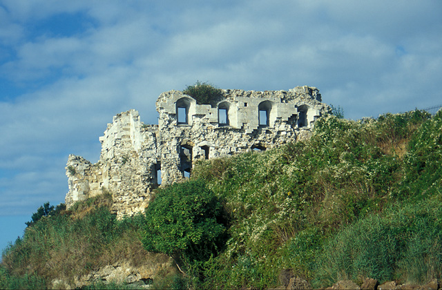
Sandsfoot Castle

Sandsfoot Castle, also known historically as Weymouth Castle, is an artillery fort constructed by Henry VIII near Weymouth, Dorset. It formed part of the...

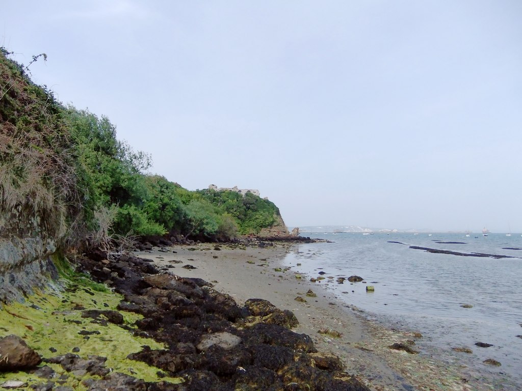
Castle Cove, Weymouth

Castle Cove, also known as Sandsfoot Cove, is a small secluded sand beach to the west of Weymouth, in Dorset, southern England. It is in the parish of...

Belfield House

Belfield House is an 18th-century country house, located in Wyke Regis, Weymouth, Dorset, England. Built around 1775-80 of stone and yellow brick in a...

Nearby Amenities

Located within 500m of 50.595415,-2.4647679
Source: PGS
Lat/Long: 50.5927781/-2.4654185
Source: PGS
Lat/Long: 50.5927774/-2.4651515
Source: PGS
Lat/Long: 50.5934647/-2.4642141
Source: PGS
Lat/Long: 50.5939823/-2.4640454
Source: PGS
Lat/Long: 50.5943326/-2.4633908
Source: PGS
Lat/Long: 50.5944183/-2.4630494
Source: PGS
Lat/Long: 50.5943658/-2.4628214
Created By: almien_coastlines
Source: PGS
Lat/Long: 50.5944345/-2.4626221
Created By: almien_coastlines
Source: PGS
Lat/Long: 50.5946653/-2.4620154
Created By: almien_coastlines
Source: PGS
Lat/Long: 50.5946812/-2.4612909
Created By: almien_coastlines
Source: PGS
Lat/Long: 50.594934/-2.4605107
Created By: almien_coastlines
Source: PGS
Lat/Long: 50.595406/-2.4603655
Created By: almien_coastlines
Source: PGS
Lat/Long: 50.5958112/-2.4602648
Created By: almien_coastlines
Source: PGS
Lat/Long: 50.5962171/-2.4600628
Created By: almien_coastlines
Source: PGS
Lat/Long: 50.5965712/-2.4600118
Created By: almien_coastlines
Source: PGS
Lat/Long: 50.596885/-2.459747
Created By: almien_coastlines
Source: PGS
Lat/Long: 50.597394/-2.458935
Parking
Capacity: 6
Lat/Long: 50.5949636/-2.4717679
Noexit: yes
Lat/Long: 50.5953575/-2.4657413
Noexit: yes
Lat/Long: 50.5956985/-2.4655507
Noexit: yes
Lat/Long: 50.5962433/-2.4649634
Noexit: yes
Lat/Long: 50.5962092/-2.4631842
Noexit: yes
Lat/Long: 50.5980171/-2.4687197
Noexit: yes
Lat/Long: 50.5986948/-2.4666174
Noexit: yes
Lat/Long: 50.5957916/-2.4626494
Turning Circle
Lat/Long: 50.5989432/-2.4644574
Turning Circle
Turning Circle: circle
Lat/Long: 50.5980444/-2.465283
Turning Circle
Turning Circle: oval
Lat/Long: 50.5987776/-2.465765
Noexit: yes
Lat/Long: 50.5975901/-2.4695938
Turning Circle
Turning Circle: circle
Lat/Long: 50.5977404/-2.4646414
Noexit: yes
Lat/Long: 50.5987701/-2.468583
Barrier: kerb
Bicycle: designated
Crossing: uncontrolled
Kerb: flush
Segregated: no
Lat/Long: 50.595831/-2.4622454
Noexit: yes
Lat/Long: 50.5981631/-2.4675072
Leisure: slipway
Lat/Long: 50.592699/-2.4649833
Leisure: slipway
Lat/Long: 50.5933475/-2.4640745
Leisure: slipway
Lat/Long: 50.5942022/-2.4638699
Description: Great views over the harbour towards Portland along this stretch towards Sandsford Castle.
Tourism: viewpoint
Lat/Long: 50.5932725/-2.4657211
Bench
Lat/Long: 50.59325/-2.4656319
Noexit: yes
Lat/Long: 50.5978537/-2.4707169
Noexit: yes
Lat/Long: 50.5980462/-2.4703462
Toilets
Lat/Long: 50.596083/-2.4612664
Noexit: yes
Lat/Long: 50.5995309/-2.4645458
Generator Method: photovoltaic
Generator Output Electricity: yes
Generator Source: solar
Generator Type: solar_photovoltaic_panel
Location: roof
Power: generator
Lat/Long: 50.5986368/-2.4649608
Generator Method: photovoltaic
Generator Output Electricity: yes
Generator Source: solar
Generator Type: solar_photovoltaic_panel
Location: roof
Power: generator
Lat/Long: 50.5983082/-2.4653712
Generator Method: photovoltaic
Generator Output Electricity: yes
Generator Source: solar
Generator Type: solar_photovoltaic_panel
Location: roof
Power: generator
Lat/Long: 50.5983201/-2.4654141
Generator Method: photovoltaic
Generator Output Electricity: yes
Generator Source: solar
Generator Type: solar_photovoltaic_panel
Location: roof
Power: generator
Lat/Long: 50.59847/-2.4657762
Generator Method: photovoltaic
Generator Output Electricity: yes
Generator Source: solar
Generator Type: solar_photovoltaic_panel
Location: roof
Power: generator
Lat/Long: 50.5984189/-2.4655938
Generator Method: photovoltaic
Generator Output Electricity: yes
Generator Source: solar
Generator Type: solar_photovoltaic_panel
Location: roof
Power: generator
Lat/Long: 50.5982844/-2.4634668
Generator Method: photovoltaic
Generator Output Electricity: yes
Generator Source: solar
Generator Type: solar_photovoltaic_panel
Location: roof
Power: generator
Lat/Long: 50.5983218/-2.4630806
Generator Method: photovoltaic
Generator Output Electricity: yes
Generator Source: solar
Generator Type: solar_photovoltaic_panel
Location: roof
Power: generator
Lat/Long: 50.5970926/-2.4631745
Generator Method: photovoltaic
Generator Output Electricity: yes
Generator Source: solar
Generator Type: solar_photovoltaic_panel
Location: roof
Power: generator
Lat/Long: 50.5935238/-2.469357
Noexit: yes
Lat/Long: 50.5948701/-2.4689403
Sandsfoot Castle
Historic Railway: halt
Railway: site
Wikidata: Q7416936
Wikipedia: en:Sandsfoot Castle Halt railway station
Lat/Long: 50.5966182/-2.4614821
Post Box
Collection Times: Mo-Fr 09:00; Sa 07:00
Operator: Royal Mail
Post Box Type: pillar
Ref: DT4 121D
Ref GB Uprn: 10015421755
Royal Cypher: EIIR
Royal Cypher Wikidata: Q33102113
Source: survey
Survey Date: 2022-09-10
Lat/Long: 50.5928751/-2.468673
Post Box
Collection Times: Mo-Fr 09:00; Sa 07:00
Operator: Royal Mail
Post Box Type: lamp
Ref: DT4 144D
Ref GB Uprn: 10015331859
Royal Cypher: EIIR
Royal Cypher Wikidata: Q33102113
Source: survey
Survey Date: 2022-09-10
Lat/Long: 50.5952231/-2.4683981
Post Box
Collection Times: Mo-Fr 09:00; Sa 07:00
Operator: Royal Mail
Operator Wikidata: Q638098
Post Box Type: lamp
Ref: DT4 100D
Ref GB Uprn: 10015457816
Royal Cypher: EIIR
Royal Cypher Wikidata: Q33102113
Source: survey
Survey Date: 2022-09-10
Lat/Long: 50.5974625/-2.4637404
Noexit: yes
Lat/Long: 50.5998451/-2.4649424
Noexit: yes
Lat/Long: 50.5962597/-2.4627832
Noexit: yes
Lat/Long: 50.5973729/-2.4678784
Noexit: yes
Lat/Long: 50.5982427/-2.4665708
Turning Circle
Turning Circle: circle
Lat/Long: 50.5980905/-2.4651802
Noexit: yes
Lat/Long: 50.5989162/-2.4662454
Noexit: yes
Lat/Long: 50.5952793/-2.4713812
Noexit: yes
Lat/Long: 50.5941548/-2.4692713
Turning Circle
Turning Circle: oval
Lat/Long: 50.5958878/-2.4663456
The data included in this document is from www.openstreetmap.org. The data is made available under ODbL.

Have you been to Southlands?

Leave your review of Southlands below (or comments, questions and feedback).