Port Uamh nan Eun

Sea, Estuary, Creek in Argyllshire

Scotland

Port Uamh nan Eun

Disused quarry at Rubha na h-Airde Mòire
Disused quarry at Rubha na h-Airde Mòire Credit: Mick Garratt

The requested URL returned error: 429 Too Many Requests

If you have any feedback on the listing, please let us know in the comments section below.

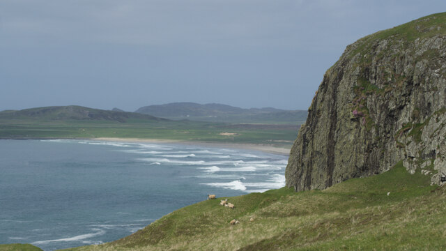
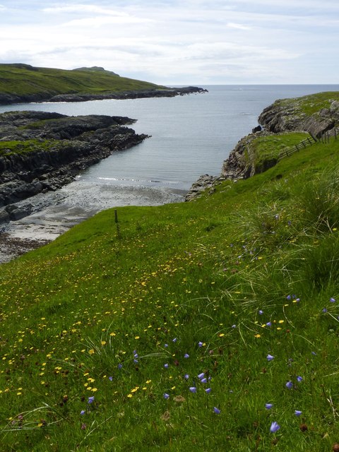
Port Uamh nan Eun Images

Images are sourced within 2km of 55.750789/-6.4636687 or Grid Reference NR2059. Thanks to Geograph Open Source API. All images are credited.

Disused quarry at Rubha na h-Airde Mòire
Kilchiaran Bay
Kilchiaran Bay
Creag Bealach na Caillich — Granny's Crag
Disused military buildings
Harebells at Kilchiaran, Islay
Looking towards Coul Point from south of Machir Bay, Islay
RAF Kilchiaran ROTOR radar station WWII Chain Home Low radar station in background
RAF Kilchiaran ROTOR radar station
WWII Chain Home Low radar station in background
View North from RAF Kilchiaran Site of RAF Saligo Bay Chain Home radar station in distance.
Kilchoman old church at right
Colonsay right distance
Machir Bay below and Loch Gorm to the right
View North from RAF Kilchiaran
Site of RAF Saligo Bay Chain Home radar station in distance. Kilchoman old church at right Colonsay right distance Machir Bay below and Loch Gorm to the right
Kilchiaran Chapel There's not much left of Kilchiaran Chapel, just the walls, a few graveslabs and what I believe to be a baptismal font.
But it's the atmosphere which makes it special, it's so remote and lonely (if you ignore the farm, which you can't see any more when you get down to the beach).
Kilchiaran Chapel
There's not much left of Kilchiaran Chapel, just the walls, a few graveslabs and what I believe to be a baptismal font. But it's the atmosphere which makes it special, it's so remote and lonely (if you ignore the farm, which you can't see any more when you get down to the beach).
House at Kilchiaran
House at Kilchiaran
Kilchiaran
Kilchiaran
Kilchiaran Farm
Kilchiaran Farm
Loch Conailbhe
Loch Conailbhe
BT Communications Tower Located close to the original site of the short-lived RAF ROTOR radar station, this tower provides the necessary links from the island of Coll, via Islay, to the Scottish Mainland.
BT Communications Tower
Located close to the original site of the short-lived RAF ROTOR radar station, this tower provides the necessary links from the island of Coll, via Islay, to the Scottish Mainland.
At Kilchiaran
At Kilchiaran
Kilchiaran Farm Information Board Kilchiaran Farm is involved in a scheme to help increase the numbers of Chough on Islay.
Kilchiaran Farm Information Board
Kilchiaran Farm is involved in a scheme to help increase the numbers of Chough on Islay.
Inside Kilchiaran Chapel Kilchiaran Chapel may date back to the 14th century.  A 1972 restoration project saved the walls and reconstructed the altar area.  (Source: "Islay" by Norman S Newton).
Inside Kilchiaran Chapel
Kilchiaran Chapel may date back to the 14th century. A 1972 restoration project saved the walls and reconstructed the altar area. (Source: "Islay" by Norman S Newton).
Kilchiaran Chapel Interior Looking from the altar end of the chapel.  The entry door is on the right hand side of this shot.  Kilchiaran Chapel belongs to the period when the Lords Of The Isles ruled Islay, between AD1156 & 1493.  (Source: "Islay" by Norman S Newton).
Kilchiaran Chapel Interior
Looking from the altar end of the chapel. The entry door is on the right hand side of this shot. Kilchiaran Chapel belongs to the period when the Lords Of The Isles ruled Islay, between AD1156 & 1493. (Source: "Islay" by Norman S Newton).
Show me another place!

Port Uamh nan Eun is located at Grid Ref: NR2059 (Lat: 55.750789, Lng: -6.4636687)

Unitary Authority: Argyll and Bute

Police Authority: Argyll and West Dunbartonshire

What 3 Words

///curbed.uplifting.training. Near Port Charlotte, Argyll & Bute

Related Wikis

RAF Kilchiaran

RAF Kilchiaran was a Royal Air Force radar station situated on the Isle of Islay in Scotland. It was originally active from 1940-1945. In 1954, the base...

Rinns of Islay

The Rinns of Islay (Scottish Gaelic: Na Roinn Ìleach; alternative English spelling Rhinns of Islay) is an area on the west of the island of Islay in the...

Kilchoman

Kilchoman ( kil-(K)HOM-ən; Scottish Gaelic: Cill Chomain [kʲʰiːʎ ˈxɔmɛɲ]) is a small settlement and large parish on the Scottish island of Islay, within...

Kilchoman distillery

Kilchoman distillery (pronounced Kil-ho-man) is a distillery that produces single malt Scotch whisky on Islay, an island of the Inner Hebrides. Kilchoman...

Nearby Amenities

Located within 500m of 55.750789,-6.4636687
Kilchiaran Bay
Natural: bay
Lat/Long: 55.7516749/-6.4671698
Power: pole
Lat/Long: 55.7470375/-6.4631654
Power: pole
Lat/Long: 55.7475786/-6.4635476
Power: pole
Lat/Long: 55.7487318/-6.4633801
Power: pole
Lat/Long: 55.7492939/-6.4628852
Power: pole
Lat/Long: 55.7502034/-6.462066
Power: pole
Lat/Long: 55.7516146/-6.4607152
Power: pole
Lat/Long: 55.7527406/-6.4588296
Power: pole
Lat/Long: 55.7532449/-6.457959
Power: pole
Lat/Long: 55.749895/-6.4623438
Power: pole
Lat/Long: 55.7508829/-6.4613782
Power: pole
Lat/Long: 55.7519537/-6.4602505
Power: pole
Lat/Long: 55.7523184/-6.4595918
Power: pole
Lat/Long: 55.7481178/-6.4639089
Port Uamh nan Eun
Natural: bay
Lat/Long: 55.7508025/-6.4635482
Port Meadhoin
Natural: bay
Lat/Long: 55.7527886/-6.464295
Port a' Bhata
Natural: bay
Lat/Long: 55.7532474/-6.4672776
Port na h-Uamha Ruaidhe
Natural: bay
Lat/Long: 55.7505907/-6.4686509
The data included in this document is from www.openstreetmap.org. The data is made available under ODbL.

Have you been to Port Uamh nan Eun?

Leave your review of Port Uamh nan Eun below (or comments, questions and feedback).